AQUASTAT - FAO's Global Information System on Water and Agriculture
Uzbekistan
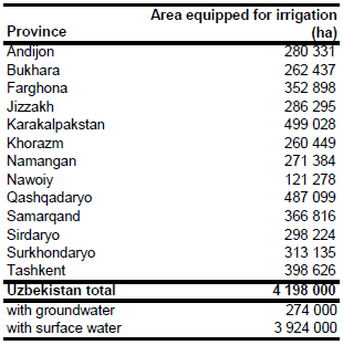
Area equipped for irrigation was 4 198 000 ha in year 2005 [UZ01]. Irrigated area in 13 provinces was available for year 1996 and totalled 4 223 000 ha [UZ02]. Area equipped for irrigation per province in year 2005 was estimated by scaling the area reported for year 1996 so that the total sum was similar to the extent reported at the national scale for year 2005. The irrigated area per province estimated that way is visible in the table below and also can be downloaded as Uzbekistan irrigation areas in PDF or Uzbekistan irrigation areas in Excel.
The irrigated areas were digitized from a map showing irrigated areas in the Aral Sea Basin [UZ03]. The shape of the boundaries of the irrigated areas was then adjusted using satellite imagery [UZ04]. The digitized irrigated areas were combined with irrigated cropland derived from the Globcover regional classification for Central Asia [UZ05]. Irrigated area was then assigned with the highest priority to pixels being irrigated according to both data sources and after that, if required, to pixels that were either covered by the digitized irrigated areas or classified as irrigated by Globcover.
Area equipped for irrigation with groundwater was 274 000 ha in year 1994 [UZ01]. More recent estimates were not available. Since the quantity of groundwater extractions is restricted to volumes that do not cause surface flow reduction [UZ06], area equipped for irrigation with groundwater was set to the figures reported for year 1994. Area actually irrigated was 3 700 000 ha in year 2005.
References
[UZ01]: FAO. 2013. AQUASTAT Country Statistics.
[UZ02]: European Commission, Directorate General. 1996. Water resources management and agricultural production in the Central Asian Republics - Warmap Project. Vol. 4: Irrigated crop production systems, Table 4.5. Tashkent.
[UZ03]: Unknown. Aral Sea Basin 1:2 500 000 - administrative boundaries and irrigated areas. Map available in the FAO-AGL library.
[UZ04]: Earth Satellite Corporation. 2004. Landsat GeoCover (2000/ETM+) Edition Mosaics, tiles 071-323, 071-324, 071-334, 071-335, 071-344 and 071-345. Sioux Falls, USA, USGS, http://glcfapp.umiacs.umd.edu:8080.
[UZ05]: ESA. 2008. Regional Globcover Land Cover – Central Asia. Version 2.2. http://postel.mediasfrance.org/en/DOWNLOAD/, 24/03/2009.
[UZ06]: FAO. 2013. AQUASTAT country profile of the Uzbekistan, version 1997. FAO, Rome, Italy.


