AQUASTAT - FAO's Global Information System on Water and Agriculture
Venezuela (Bolivarian Republic of)
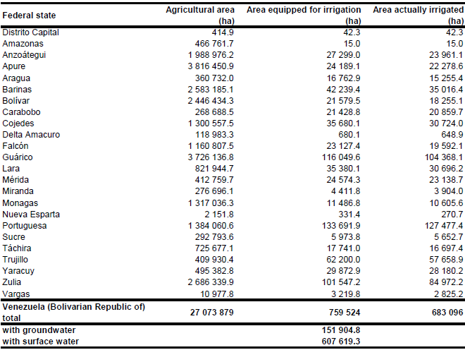
AEI and AAI per Parroquia were derived from the data base of the agricultural census 2007/2008. The total area equipped for irrigation in the Bolivarian Republic of Venezuela equals 759 524 ha, while area actually irrigated in season 2007/2008 was 683 095 ha [VE01]. The irrigated areas by state are shown in the Table below. The irrigated areas both by state and by parroquia can be downloaded as the Bolivarian Republic of Venezuela irrigation areas in PDF or the Bolivarian Republic of Venezuela irrigation areas in Excel (two sheets).
Most of the irrigated area is located in the northern part of the country. The irrigated area was distributed within the Parroquias according to irrigation maps originating from an FAO review on the irrigation and drainage sub-sector done in 1990 [VE02] and a CIAT map with irrigated rice [VE03]. The remaining irrigated area was assigned was assigned to all regions classified as agriculture (intensive) in the GLC2000 land cover classification for South America [VE04] and if the extent of these areas was still to small to regions classified in the same data set as mosaic of agriculture and degraded vegetation or degraded forest respectively.
Data related to the source of irrigation water are scarce for Venezuela. In 1989 about 2 percent of the cropland in public irrigation schemes was irrigated with groundwater [VE05] while the contribution of groundwater to total water abstraction was reported at 50 percent [VE06]. There is evidence that groundwater extraction for irrigation resulted in an overuse of several important aquifers [VE06]. Since the majority of irrigation is in private schemes [VE05], AEI irrigated with groundwater was estimated at 20 percent for Venezuela.
References
[VE01]: Ministerio del Poder Popular para la Agricultura y Tierras. 2010. VII Censo Agrícola Nacional. Ministerio del Poder Popular para la Agricultura y Tierras, http://200.47.151.243/, 18/03/2012.
[VE02]: FAO. 1990. Venezuela - Irrigation and Drainage Subsector Review.
[VE03]: CIAT. 1997. Distribution of rice in Latin America. http://www.gis.ciat.cgiar.org or http://www.grida.no/prog/global/cgiar/.
[VE04]: Eva, H.D., de Miranda, E.E., Di Bella, C.M., Gond, V., Huber, O., Sgrenzaroli, M., Jones, S., Coutinho, A., Dorado, A., Guimarães, M., Elvidge, C., Achard, F., Belward, A.S., Bartholomé, S., Baraldi, A., De Grandi, G., Vogt, P., Fritz, S. & Hartley, A. 2003. The land cover map for South America in the year 2000. GLC2000 database, European Commision Joint Research Centre, http://www-gem.jrc.it/glc2000, 10/08/2006.
[VE05]: FAO. 2000. AQUASTAT country profile of Venezuela (República Bolivariana de), version 2000. FAO, Rome, Italy.
[VE06]: Jegat, H., Alvarado, J., Loaiciga, H.A. 1995. Overexploitation and deterioration of aquifers in Venezuela. Ground Water Monitoring & Remediation 15, 119-123.


