AQUASTAT - FAO's Global Information System on Water and Agriculture
South Africa
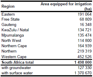
Area equipped for irrigation is 1 498 000 ha [ZA01]. The figures refer to year 2000 and are derived from a remote sensing based national land cover inventory [ZA02]. Sub-national information on areas equipped for irrigation is visible in the table below and also can be downloaded as South Africa irrigation areas in PDF or South Africa irrigation areas in Excel. However, the information refers to the same land cover inventory. To avoid a replication of information, the statistics have not been used.
Area equipped for irrigation was assigned to grid cells by using the areas classified as irrigated in the land cover inventory [ZA02].
Area actually irrigated was assumed to be similar to area equipped for irrigation [ZA01]. Area irrigated with groundwater was 8.5 percent of total area equipped for irrigation (127 330 ha) in year 2000 while the remaining part was irrigated with surface water resources [ZA01].
References
[ZA01]: FAO. 2016. AQUASTAT country profile South Africa, FAO, Rome, Italy.
[ZA02]: Thompson, M.W. 1999. South African national land cover database project. CSIR. Data set on CD-ROM, available at: http://www.sac.co.za


