![]()
![]()
![]()
According to current estimates the river fisheries of Africa contribute about 40 percent of the 1.1 million tons of fish caught in the freshwaters of the continent each year. Rivers however, play a role in many other fields of activity, particularly agriculture, with its need for flood control and irrigation, power generation with its accompanying dams and reservoirs, and industrial and domestic water use with its attendant pollution risks. These activities conflict not only amongst themselves but, by modifying the ecosystem, interfere with the maintenance of stocks of fish adequate for the support of fisheries. The rational management of river basins should take the needs of each of the uses into account and the policy decisions required depend upon the existence of an adequate informational base.
In spite of their important role in the production of animal protein for food, surprisingly little information exists on the biology of riverine fish stocks, or the yields, potential and actual, of their fisheries. By and large statistics on fish catch are sparse and much less well documented than the equivalent data from lakes. The amount of data available on lakes has permitted an examination of the possible use of a Morpho-Edaphic Index for the quick appraisal of potential production from these waters (Henderson and Welcomme, 1974). Such quick appraisal methods, although generally only approximative can play an invaluable role in policy-making and management of fisheries in that the information required for generalized decisions is readily and cheaply available. Such a method is lacking for rivers and an attempt is made here to examine the small amount of data existing in order to define some of the characters which may be used for approximative determination of possible river yields. Any analysis made from such incomplete data must necessarily be speculative and the purpose of this paper is not so much to present a definitive argument for river productivity as to stimulate discussion and research in this vital sector.
Rivers tend to conform to known physical and chemical laws which determine the relationship between such parameters as river length and drainage basin area or numbers and lengths of rivers of different ranks (Leopold, Wolman and Miller, 1964). Figure 1 shows the relationship between drainage basin area in square kilometres and main channel length for 27 African rivers. There is relatively little scatter of points and the regression formulae length = 5.2424 area0.4483 and area = 0.07329 length2.05882 - have correlation coefficients r = 0.9291 and r = 0.9231 respectively. The equation for length as the dependent variable resembles the equation L = 1.4 Ad 0.6 derived from various large rivers of the world (Leopold, Wolman and Miller, 1964). The coefficient of 5.2 however indicates a longer narrower basin for African rivers of small dimensions, and the line is less steep with an exponent of 0.45.
The concept of stream length and stream number has been described by Horton (1945). Stream order is a method of defining the position of a stream in a hierarchy of tributaries. First-order streams are those which have no tributaries, second-order streams those which have as tributaries only first-order streams and so on. The actual order number depends on the scale of map used for the measurement. The longest tributary of each order is usually considered to extend headward to contribute to the length of the main channel of the river.
A log relationship has been shown to exist between the number and the length of streams of each order and these have been plotted in Figure 2 from such information as is available on number and length of rivers of the three highest orders in Africa. The extrapolated lines (i) number of streams = 1.9719 × 10⁷ (0.21 Stream order) and (ii) stream length = 0.695(2.3014Stream order) thus obtained are based on fairly broad assumptions and more accurate plots could be made after lengthy counts of the smaller rivers of the continent. It is however doubtful whether this exercise would be worth the time necessary for it at this stage, as the numbers and lengths obtained (Table I) appear consistent with expected values. For example the total length of the water courses within this range of size is 12.8 million km for Africa as compared with 5.2 million km calculated for the United States of America (Leopold, Wolman and Miller, 1964). As the non-desert area of Africa is about 20 million km2 and that of the United States about 9 million, the ratio of channel length to area drained is similar.
Table I
Estimated number and length of various sizes of river channel in Africa
(excluding tributaries of smaller order)
| Order | Number | Average length (km) | Theoretical total length (number × average length) | River representative of each size |
| 1 | 4166969 | 1.6 | 6667150 | |
| 2 | 870615 | 3.6 | 3203865 | |
| 3 | 181900 | 8.5 | 1540693 | |
| 4 | 38005 | 19.5 | 741097 | |
| 5 | 7940 | 44.8 | 356347 | |
| 6 | 1659 | 103.3 | 171358 | |
| 7 | 347 | 237.7 | 82492 | Moa |
| 8 | 72 | 547.1 | 39392 | Ouémé |
| 9 | 15 | 1259.1 | 19013 | Volta |
| 10 | 3.2(3) | 2897.8 | 9273 | Niger |
| 11 | 0.7(1) | 6669.0 | 4668 | Nile |
| Total | 12835346 |
The form of a river channel undergoes changes along its length, and although there is no sharp distinction between the various patterns, three major types of river reaches or gradients can be distinguished each of which has a different significance for fisheries:
Steep and rocky sections which are torrential in the floods and normally dessicate completely during the dry season. Such sections are encountered in uplands and are usually headwater streams.
Deeply encased sections of moderate slope, often with alternating rocky and sandy stretches, which tend to break down into a series of pools in the dry season, but which become torrential and overflow onto a restricted floodplain during the floods.
Sections with wide shallow meandering or braided channels, with low banks flanked by extensive floodplains. The floodplains are usually interspersed with oxbows, lakes and permanent swamps.
Sections (ii) and (iii) may alternate in the river channel depending on the local topography but in general the river tends to progress from (i) to (iii) as it approaches its mouth.
In certain instances, extraordinarily large floodplain areas are imposed in the general pattern. These arise due to quirks of local topography and may be thought of as apart from the “normal” evolution of the river in its course downstream. They may therefore be considered in much the same way as lake or permanent swamp areas of a river basin. Such floodplains make up 1 percent or more of the drainage area and the most notable of these are listed in Table II below.
Table II
Areas of major African floodplains relative to drainage basin area
| River | Floodplain area (km2) | Drainage area (km2) | % |
| Niger | 17 000 | 1 125 000 | 1.5 |
| Chari/Logone1 | 6 000 | 600 000 | 1.0 |
| Senegal | 4 560 | 338 000 | 1.35 |
| Ouémé | 1 000 | 40 150 | 2.4 |
The different zones of the river each support characteristic communities of fish. The differences between the zones, and the tendency for river reaches toward the headwaters to dessicate during the dry season, may give rise to considerable differences in the ichthyomass supported by them, but this may be evened out over the year by the extensive movement of fish toward the headwaters during the floods.
Rivers vary in nature regionally within the African continent. Daget and Iltis (1965) classify West African rivers into: (i) Guinean and (ii) Soudanien types.
Guinean rivers, such as the Komoé, are those which drain the forested areas of West Africa and extend into the Congo/Zaire system. They run most of their course through gallery forest and have floodplains which consist of large areas of inundated forest floor. The pH of such rivers tends to be low and the humic acid content high. They are reputedly less productive than Soudanien rivers although accurate figures are not available on relative production of the two types.
Soudanien rivers such as the Niger are those draining the open savannah regions. They have little or no fringing forest and flood extensive areas during seasonal high waters of varying duration.
Many river systems have a combination of these characteristics with both Guinean and Soudanien stretches.
A further classification of rivers into the (i) “sandbank” and (ii) “reservoir” is described by JFRO (1959).
Sandbank rivers of which the main channel of the Zambezi is an example have deep beds, steep banks and at low level may consist of only a series of rock-fringed pools on the sandy bed.
Reservoir rivers flow out of either lakes or swamps which act as a reservoir of surplus rainwater. They are neither very high nor very low at any stage in their cycles and retain a margin of vegetation along their ill-defined banks at all times of the year.
During the flood season the adjoining plains of both types are inundated, but in the case of sandbank rivers only for a very short period.
The pH and conductivity of a number of African rivers are listed in Table III from which it may be seen that there is relatively little difference in these factors between rivers. In fact differences within one river system are liable to cover a greater range than differences between river systems. The tendency for higher order rivers (underlined in Table III) to approach a characteristic composition is well known (Hutchinson, 1957; Gibbs, 1970) and may be explained by processes which tend toward equilibrium (e.g. evaporation, crystallization, solution, ion-exchange) and by simple mixing of waters contributed by different portions of the drainage basin. The geological mosaic of a continent is of sufficiently fine grain that only relatively small (low order) rivers can be expected to exhibit edaphic variability in the major dissolved components of the water.
Table III
Conductivity and pH of major African river systems
(based on data collected from various sources by Welcomme, 1972)
| River | Conductivity river channel | K20 μ mhos floodplain pools | pH |
| Sewa | 14–21 | 6.4–6.0 | |
| Moa | 36 | 6.6 | |
| Robel | 40 | 6.9–7.3 | |
| Lt Scarcies | 35–55 | 7.1–7.4 | |
| Niger | 31–70 | 82 | 6.7–7.2 |
| Chari | 42–73 | 6.9–7.7 | |
| Zambezi | 50–96 | 57–102 | 7.4 |
| Congo | 44–108 | 5.5–6.5 | |
| Volta | 41–124 | 6.5–7.3 | |
| Senegal | 40–130 | 73–385 | 6.8–7.1 |
| Mayo Kebbi | 89 | ||
| Kagera | 93–99 | ||
| Ouémé | 60–150 | 150–160 | |
| Sobat | 112 | ||
| Prah | 140 | ||
| Bandama | 145 | 6.7–7.6 | |
| Orange | 159 | 7.7 | |
| Luapula | 150–180 | ||
| Nile | 150–240 | 116 | |
| Lualaba | 145–255 | 145–255 | |
| Ruaha | 93–310 | 7.4–7.8 | |
| Shire | 220–225 | 7.5–8.8 | |
| Kafue | 130–320 | 70–280 | |
| Bugungu | 245–395 | 230–350 | |
| Bahr-el-Ghazal | 550 | 7.8 | |
| Semliki | 400–910 | ||
| Ruzizi | 828 |
Conductivity varies with flood regime and in several areas of Africa a temporary increase has been noted during the earliest part of the flood. Such changes are however relatively slight and one reason for this may be that the rapid growth of aquatic vegetation at times of rising water readily absorbs any free salts that enter the system from the newly flooded areas. Later decay and burning of the vegetation during the dry season would return such salts to the soil and not to the aquatic component of the system.
When the range of variation in conductivity of river waters is compared with that of lakes it is relatively restricted. The higher and lower values in the table are relatively rare and the more normal range is between 30 and 300 μ mhos. Assuming the floodplains to be inundated to a uniform depth of 1 m this would correspond to a range of fish production of between 72–200 kg/ha/year when estimated from the Morpho-Edaphic Index (Henderson and Welcomme, 1974). Actual values, which range between 3–100 kg/ha/6 months, and estimated values 40–60 kg/ha/6 months (Welcomme, 1974) agree fairly well with this prediction.
Because of their lower conductivity African river waters have only a low buffering capacity. Nevertheless variations in pH are relatively slight. In general forest rivers of the Guinean type have a lower pH than savannah rivers of the Soudanien type, but these differences are probably not great enough to influence the productivity of the water. Only in the acid-humic waters of the middle Congo, with their extremely low pH of 4.2–5.5 (Berg, 1961) is productivity likely to be adversely affected.
The present catch from African rivers may be estimated either by country (Table IV) or by individual river system (Table V). In both cases a total annual tonnage of about 400 000 t is derived.
Table IV
Present Estimated Catch from Rivers in African Countries
| Country | Catch (t) |
| Cameroon | 48 000 |
| Central African Republic | 3 500 |
| Congo | 6 000 |
| Chad | 55 000 |
| Dahomey | 9 700 |
| Egypt | 15 000 |
| Gambia | 800 |
| Liberia | 4 000 |
| Malawi | 11 400 |
| Mali | 90 000 |
| Mauritania | 15 000 |
| Niger | 9 700 |
| Nigeria | 29 000 |
| Senegal | 28 000 |
| Sudan | 18 000 |
| Uganda | 4 800 |
| Upper Volta | 5 000 |
| Zaire | 75 000 |
| Zambia | 13 000 |
| Total | 441 400 |
Table V
Present Estimated Catch of the Major River Systems of Africa
| River basin | Catch (t) |
| Niger | 114 146 |
| Chari/Logone | 87 000 |
| Zaire/Oubangui | 69 000 |
| Senegal | 40 000 |
| Nile | 38 000 |
| Benue | 12 570 |
| Zambezi | 11 800 |
| Shire | 11 400 |
| Ouémé | 6 484 |
| Gambia | 800 |
| Tana | 500 |
| Total | 414 694 |
Of this tonnage some 180 000 t originate from the four main floodplain areas listed in Table II, and the remainder comes from all the other river systems.
If the catch from the various rivers, for which such data are available, is plotted against basin area (or main channel length) a linear log-log relationship c = 0.0736 a0.8898 (r = 0.959) is obtained (Figure 3). The high correlation coefficient for this line indicates remarkable agreement considering the nature of the data from which it is plotted. A similar, almost parallel line c = 0.4039 a0.9123 (r = 0.9967) is obtained when the catch from the four major floodplain rivers is plotted against basin area. The good agreement in this case is less surprising. Data from such concentrated fisheries is liable to be more accurate, and as is shown in Figure 6 a strong correlation exists between floodplain area and catch, the floodplains of these rivers comprising similar proportions of the drainage basin area (Table II).
The total area of Africa is just over 30 million km2. of this about 10 million km2 is desert. A cumulative plot of the area of river drainage basins in Africa shows that this tends toward an asymptote of 15 million km2 (Figure 4). The remaining 5 million km2 is probably accounted for by semi-desert regions with temporary or highly seasonal water courses.
Data from Figures 3 and 4 can be combined to give an estimate of production from the major river basins (Table VI) exclusive of the yield from the four major floodplains areas. The estimate of 230 000 t derived plus the 180 000 t from the floodplains gives a total of 410 000 t, a figure very similar to the obtained from existing catch statistics.
The estimates of production in the preceding sections are probably based only on those areas of rivers where fisheries are intense enough to attract the attention of fisheries a administrators and biologists. In such regions sufficient quantities of fish are landed for the setting-up of marketing networks and to justify the expense of statistical collection and sampling. For this reason the present statistics can be regarded as reflecting the catch of only the major floodplain areas and of higher order streams which are sufficiently large to support moderate to large artisanal fisheries.
Table VI
Calculation of Yield from Major River Basins of Africa
| Number of basins | Range of area (km2) | Total area (km2) | Mean area (km2) | Mean yield c=0.0736a0.8898 | Total yield (t) | % of total |
| 1 | 4×10⁶ | 4 015 500 | 4 015 500 | 55 308 | 55 308 | 24.33 |
| 1 | 3×10⁶ | 3 000 000 | 3 000 000 | 42 680 | 42 680 | 18.78 |
| 3 | 1.3-1×10⁶ | 3 425 500 | 1 131 000 | 17 916 | 53 748 | 23.53 |
| 2 | 6.4-6×10⁵ | 1 240 000 | 620 000 | 10 494 | 20 988 | 9.23 |
| 4 | 3.9-3.4×10⁵ | 1 436 000 | 384 000 | 6 852 | 27 408 | 12.06 |
| 5 | 17.9-9.2×10⁴ | 643 000 | 108 600 | 2 227 | 11 135 | 4.90 |
| 7 | 8.0×4.0×104 | 466 000 | 66 570 | 1 441 | 10 087 | 4.44 |
| 10 | 3.0-1.3×10⁴ | 200 500 | 20 050 | 495 | 4 950 | 2.18 |
| 5 | 9.5-3.0×10³ | 34 500 | 7 000 | 194 | 970 | 0.43 |
| Total | 14 464 000 | 227 274 |
A characteristic of river fisheries is however their dispersed nature and such relatively large-scale fisheries may be regarded as being the exception rather than the rule. It has already been shown in Figure 2 and Table I that the majority of the river length is concentrated in the lower order streams. Individually these have a small potential production and many kilometres have to be fished to support even a low level of artisanal activity. They do however support subsistence fisheries the extent of which can only be guessed at, although as any observer from Africa knows one or two small boys or women are inevitably found on even the smallest streams where fish occur.
It is therefore proposed that the estimates of production based on major fisheries are extremely low and undervalue the importance of the river fish as a component of the food of the people. Artisanally produced fish of this nature is very difficult to detect as it enters immediately into the diet of the consumer without passing via an intermediary.
The following speculative analysis attempts to evaluate the importance of this resource.
Figure 5, based on data extrapolated from Figure 3, plots the annual catch per kilometre of river with increasing distance from the source. This is presented as a single line, although in reality it is probably divided into several components corresponding to the river sections described in 2.2. Also plotted are actual values for the Niger (FAO,1962) and Pendjari (FAO,1971) rivers, and for the Niger and Benue Rivers in Nigeria (FAO,1970). The latter series of points (1–11) are further analysed in Figure 6 by plotting the catch per kilometre of river against the total area covered by water during maximum flooding. Even the use of this primitive criterion shows a good correlation to exist between floodplain area and catch (r=0.6921 for calculated line c = 1.8352a - 0.8336). The line in Figure 5 can thus be regarded as a good approximation upon which further calculations can be based at least for type (iii) reaches of river. Further work on yield per kilometre of river is nevertheless desirable for improving and increasing the accuracy of this model.
By integrating values calculated from the predictive line g=0.0363 d0.7055 from Figure 5 it is possible to calculate the theoretical yield of the river sections of the various stream orders quoted in Table I, and from this the total yield to be expected from the totality of stream in each order. The results of these calculations are presented in Table VII and the total yield estimated for the river systems of Africa is 1 300 000 t.
Table VII
Number and Length of Various Sizes of River Channel in Africa (excluding tributaries of smaller orders) together with a Theoretical Calculation of the Production of Fish from Each
| Order | Number | Average length (km) | Average yield (t) | Total yield (t) | % |
| 1 | 4 166 969 | 1.6 | 0.053 | 222 473 | 17 |
| 2 | 870 615 | 3.6 | 0.223 | 194 171 | 15 |
| 3 | 181 900 | 8.5 | 0.877 | 159 570 | 12.3 |
| 4 | 38 005 | 19.5 | 3.961 | 150 549 | 11.5 |
| 5 | 7 940 | 44.8 | 15 662 | 124 358 | 9.4 |
| 6 | 1 659 | 103.3 | 61.801 | 102 527 | 7.7 |
| 7 | 347 | 237.7 | 276.311 | 95 880 | 7.2 |
| 8 | 72 | 547.1 | 1 100.834 | 79 260 | 6.0 |
| 9 | 15 | 1 259.1 | 4 425.453 | 66 824 | 5.0 |
| 10 | 3.2 | 2 897.8 | 19 758.623 | 63 227 | 4.8 |
| 11 | 0.7 | 6 669.0 | 77 394.851 | 54 176 | 4.1 |
| Total | 1 313 015 |
This figure is considerably larger to the presently estimated 400 000 t and also omits production from the four major floodplains due to its derivation from the line for general river channel catches.
The estimate is however for the total non-desert area of Africa of 20 million km2 of which one quarter is semi-arid with temporary rivers of possibly limited productivity. Taking this into account and reducing the estimate by one quarter accordingly an estimate of about 1 000 000 t from rivers generally or 1 200 000 t from rivers plus the major floodplain is obtained.
Two further points emerge from the table. Firstly, the production of the 19 rivers of the three highest orders is about 200 000 t, a figure close to the conventionally recorded catch; as expected from the assumption that only fish caught in major river stretches are at present recorded. Secondly, the majority of production from rivers potentially comes from the enormous number of lower order streams (65 percent from rivers of less than 100 km in length) and is, in all probability, not only unrecorded but unrecordable. The proportion of this theoretical production that is actually caught is not known. It may however be assumed that in densely populated areas the resource is exploited near its maximum potential, whereas in certain areas where rivers are shunned due to their association with encocerciasis fishing is still carried out at a low level.
Two levels of estimation of catch are considered in the foregoing analysis.
The present actual production from rivers as determined from the catch at certain sites where extensive commercial fishing takes place.
The theoretical production, extrapolated from the above figures for all rivers; the proportion of this theoretical catch that is actually caught not being known at the present time.
A third level of estimation, the potential production, is not considered as there is as yet no information which would permit such an analysis to be made. Commercial catches from the major river fisheries may approach the maximum sustainable yield from such waters, in which case estimate (b) above would be a good approximation of this potential, or they may be low, in which case estimate (b) is also low.
The estimate of 1 200 000 t theoretical production, which may or may not be accurate is probably not unreasonable in view of the enormous river resources of the continent and serves to illustrate a number of points relevant to African river fisheries. What is clear is that, up to the present time, very little attention has been paid to riverine fisheries and as a result little data exist upon which to base a more rigorous evaluation of their potential. The gross catch from such fisheries is very probably underestimated, and as a result the allocation of research funds has been biased by the apparently greater importance of lake fisheries. This situation is aggravated by the difficulty of carrying out research programmes on such spatially dispersed resources as rivers. However, local research programmes on water courses of any size would be most helpful in this regard, for from the data available rivers appear reasonably similar in their characteristics.
The indication that a great proportion of catch from the rivers comes from the numerous lower order streams of the continent has interesting implications for management and conservation policies. It must be recognized that at the present stage of fisheries management fishing in such waters is largely uncontrollable, but they nevertheless represent an important resource which is introducing protein directly into the diet of people usually isolated from other sources of fish. Because of their tendency to dessicate, or if permanent due to their torrential course, lower order streams generally support only restricted indigenous populations of fish which are usually of small size and dispersed concealed in the rocky bed. However, during flood seasons they tend to become occupied by fish migrating from higher order streams. Thus the basis of fish production in such small water courses may also be said to rest on conditions lower down the river. Because of this, mismanagement or disturbances to the ecosystems such as interrupted passage by dams, or massive pollution, may wipe out run of fish into many small rivers upstream of the area affected.
The main factors regulating production from rivers appear to be morphological and arise from two possible sources. The first is the proneness to dessication, and the second the extent of the lateral floodplain. In fact production from the main channel of the river appears relatively low compared to the floodplain component when considering individual channels. Edaphic factors seem to play a much less significant role in the variation in productivity between different water courses, reaches of the same water course and, except in extreme cases, such as the acid-humic waters of the middle Zaire, probably are not significant at our present rather crude level of accuracy in estimation. However, considerable further work is needed to define more exactly the role of the various factors in regulating river productivity many of which may not have been considered in this paper.
I wish to thank my colleagues of the Aquatic Resources Assessment and Survey Service of the Department of Fisheries for their helpful comments on the manuscript and in particular to express my gratitude to Dr. H.F. Henderson for the many fruitful discussions leading up to the formulation of the ideas expressed here. Thanks are also due to Messrs. S. Landi and G. De Manincor, who carried out the regression analysis.
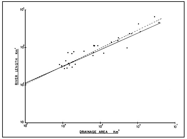
Figure 1 Relationship between drainage basin area (km2) and main channel length (km) for 27 African rivers with calculated regression lines for a = 0.073312.0588 (dashed line) and 1 = 5.2424a0.4483 (solid line)
Relations entre la superficie du bassin hydrographique (km2) et la longueur du chenal principal (km) pour 27 cours d'eau africains; courbes de régression calculées pour a = 0,073312,0588 (ligne pointillée) et 1 = 5,2424a0,4483 (ligne continue)
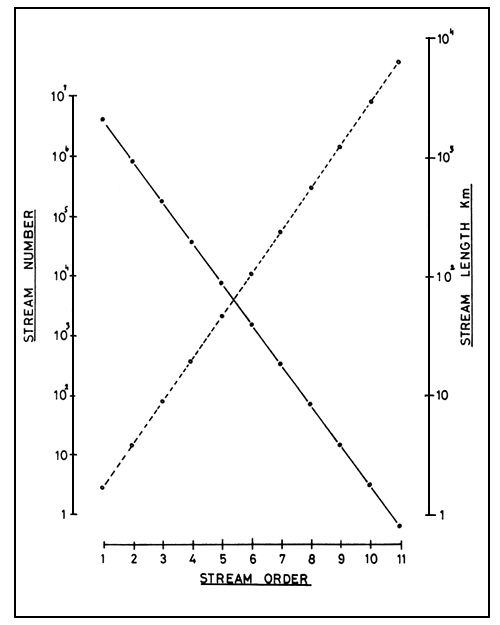
Figure 2 Theoretical relation of stream number (•—•) n = 1.9719 × 10⁷(0.210s) and stream length ○---○) = 0.6952(2.3014s) to stream order
Relation théorique entre le nombre (•—•) n = 1,9719 × 10⁷(0,210s) et la longueur des cours d'eau (○---○) = 0,6952(2,3014s) et leur ordre de grandeur
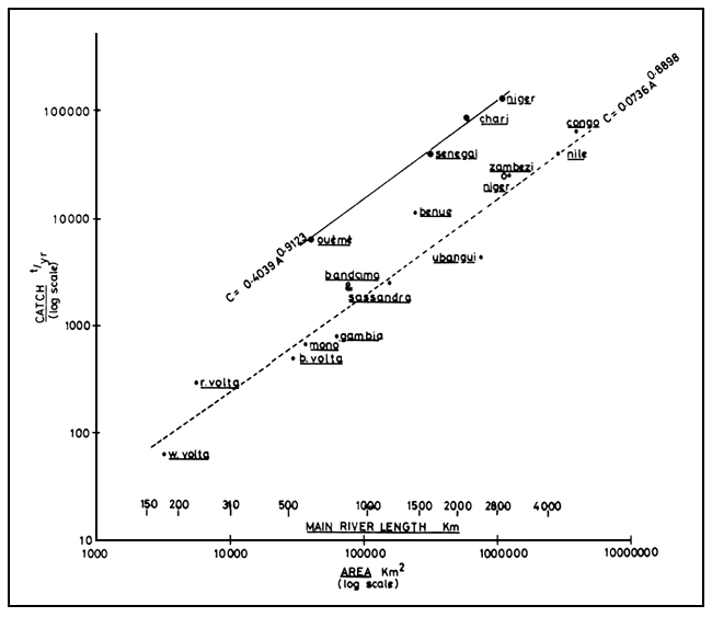
Figure 3 Catch relative to drainage basin area and main channel length in African rivers
(—) Rivers with extensive floodplain systems; calculated line c = 0.4039a0.9123
(---) Rivers with restricted floodplains; calculated line c = 0.0736a0.8898
The open circle represents the production of the Niger River without the Central Delta
Captures par rapport à la superficie du bassin hydrographique et à la longueur du bras
principal dans les cours d'eau africains
(—) Cours d'eau ayant des systèmes extensifs de plaines d'inondation; courbe calculée
c = 0,4039a0,9123
(---) Cours d'eau ayant des plaines d'inondation limitées; courbe calculée
c = 0,0736a0,8898
Le cercle ouvert représente la production du fleuve Niger sans le delta central
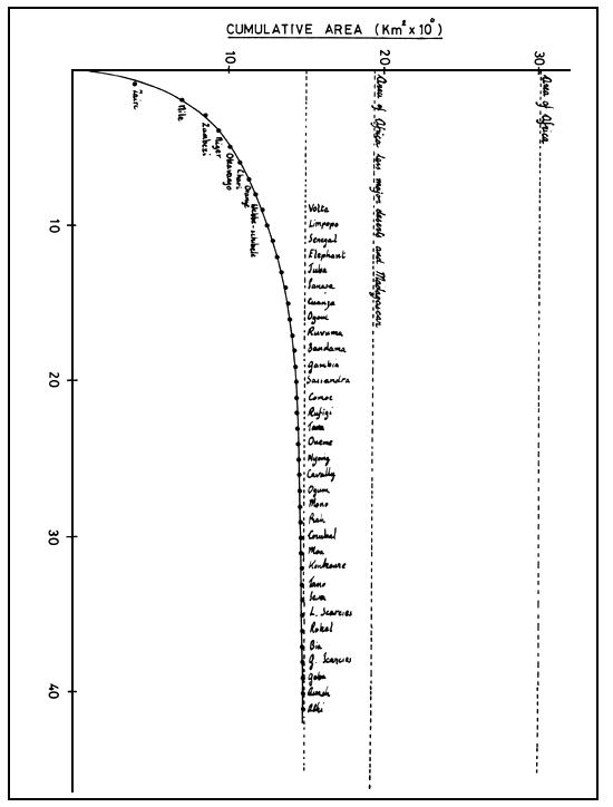
Figure 4 Cumulated area of the 41 major independent river drainage basins of Africa. Asymptotic area 15 000 000 km2
Superficie cumulée des 41 bassins hydrographiques indépendants les plus importants d'Afrique. Superficie asymptotique 15 millions de km2
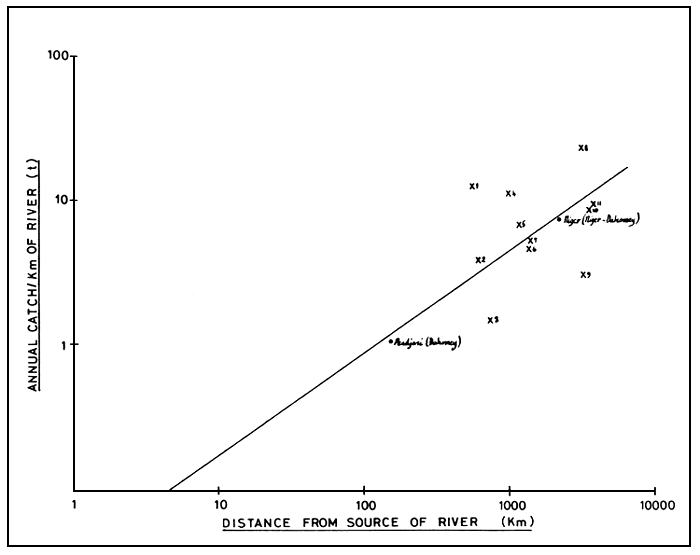
Figure 5 Theoretical line y = 0.0363d0.7055 for yield per kilometre of river (y) at different distances from the source (d). Also plotted are actual values from various sites on the Niger and Benue and Pendjari Rivers
Courbe théorique y = 0,0363d0,7055 pour le rendement par km de cours d'eau (y) à des distances différentes de la source (d). Les valeurs réelles des divers emplacements sur les fleuves Niger, Bénoué et Pendjari sont également portées sur le graphique
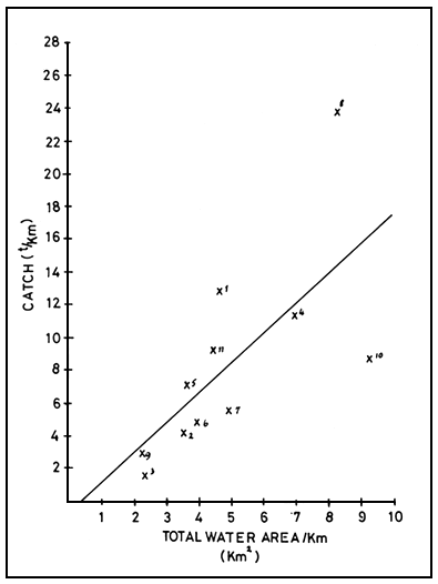
Figure 6 Catch per kilometre section of river related to the water area in km2 of the river section (total area of floodplain and river at high water). The numbers refer to the same sections plotted in Figure 5
Captures par kilomètre de cours d'eau par rapport à la superficie des eaux en km2 du tronçon de cours d'eau (superficie totale de la plaine d'inondation et du cours d'eau en période de crue). Les nombres se réfèrent aux mêmes parties qui sont portées sur la figure 5
![]()
![]()
![]()