![]()
![]()
![]()
The Valleys of Andorra is an autonomous co-principality in the Eastern Pyrenees in southwest Europe. Bounded by France and Spain, it is under their joing suzerainity.
Largest of the mini-states (after the Holy See, Monaco, San Marino, Liechtenstein and Malta), its agricultural and pastoral economy has shifted to tourism and trade.
Its terrain is high, its climate is alpine, and it has only one river basin, the Valira. Its fishing is one of angling, especially for trout and pike.
| 1. | AREA: | 453 km2 | |
| 2. | POPULATION: | 48 000 (est. 1987) | Density: 106 inh/km2 |
| 3. | PHYSICAL GEOGRAPHY | ||
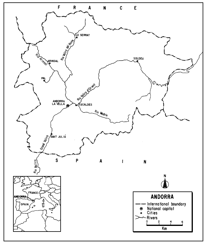
The co-principality of landlocked Andorra is situated between 42°26' and 42°39'N latitudes and 1°25' and 1°48'E longitudes, on the southern slopes of the Eastern Pyrenees.
Roughly circular, it is only 30 km (E–W) long and 27 km (N–S) wide. Its altitudinal range is from about 900 m to 3 050 m with an average elevation of about 1 830 m.
Andorra has a perimeter of 125 km, being bounded by France on the north and east for 60 km and by Spain on the south and west for 65 km.
It is surrounded by peaks, 1 500 to 3 000 m in height except on the southwest and most of the country is mountainous, with gorges, defiles, narrow valleys which end in steep cirques, and little level surface. Chestnut and walnut trees grow only at the lowest elevation, evergreen oaks, birch, pines and firs are common in higher areas. There are, however, no trees at the highest altitudes which support only alpine plants.
4. CLIMATE
The climate is temperate, alpine, cool and dry. The summers are warm or mild. The winters, at this high elevation, are severe with a long and heavy snowfall that blocks passes and remains for several months. The temperature varies greatly with altitude. Most of the rain falls in spring and autumn. The driest month is January with 74 mm and the wettest is May with an average of 105 mm.
5. HYDROGRAPHY AND LIMNOLOGY
Situated in a single drainage basin, Andorra's main stream, the Riu Valira (also known as Balira), only about 52 km long, has two distinct branches. One of these, the Valira del Norte (24 km), and its principal tributary, the Arinsal River, drain western Andorra. The Valira del Orien (28 km) drains the eastern part and has a tributary, the Madriu. The two branches unite in southwest Andorra to form the Gran Valira which leaves the country to join the Segre River 11 km south of the border in northeastern Spain. The Segre is a tributary of the Ebro; thus, all of Andorra's drainage is Mediterranean.
There are also some small natural lakes, and there has been impoundment for hydroelectric purposes. Lake Englolasters in south-central Andorra has had its water level raised 10 m by a dam.
6. LAND AND WATER USE
The exact extent of inland water in Andorra with respect to the total area of the principality cannot be determined from easily-available land use tables such as Table 1. It is obviously very small.
Table 1
Pattern of land use in Andorra, 1986
| Percent | |
| Arable and permanent crops | 2.2 |
| Permanent pasture | 55.6 |
| Forests and woodland | 22.2 |
| Other land | 20.0 |
| Total | 100.0 |
Source: 1987 FAO Prod.Yearb., 41 (Publ. 1988)
Because of its mountainous nature, less than 3 percent of the land is suitable for crops despite terracing at higher elevations. In addition, drought above 1 400 m and flooding by seasonal torrents at lower elevations places restraints on agriculture. There is, however, some irrigation using surface water, especially in the high meadow areas. Tobacco, cereals, potatoes and vegetables are cultivated. Most of the cropped land is used for hay production for animal feed. Cattle, goats and especially sheep are grazed as a principal use of the land. They follow the seasons, grazing at higher altitudes during the summer, and a considerable number of sheep are brought in from France and Spain.
There is a little quarrying and mining for iron, lead and alum.
Once densely forested, much of Andorra's forest land has been destroyed by over-grazing and use for charcoal. Today, reforestation, chiefly with pines, is progressing, and rotational cropping is practised. Nevertheless, the forested area is decreasing.
The hydroelectric potential is still large, although a number of hydroelectric plants have been established. Energy production from this source was about 110 million kWh in 1973 (U.S. Dept. State, 1982). Most of the power is exported to France and Spain.
Industry is very light, concentrating on tobacco, woollen products, furniture, leather and distilled liquors.
There are no international airports or railways in Andorra, and the road system is not extended. It is, however, adequate for the country, having a density of about 0.2 km/km2 (1979) and there is a high percentage of automobile ownership, about 620 per 1 000 people (1983). Buses are, however, the principal of mass transport.
Tourism has become the principal industry of this formerly pastoral country. Trade, duty-free markets, fairs, festivals and skiing contribute to this. In 1982, about 73 percent of the population was foreign, and about ten million people visited the country. There is a heavy concentration of people in the capital, Andorra la Vella, leaving much of the country in a still rural state where both angling and hunting (there is a season for chamois) continue.
7. FISH AND FISHERIES
No catch statistics for Andorra's fisheries are available. The FAO Yearbooks of Fishery Statistics merely indicate that they are nil or insignificant.
The streams contain brown trout (Salmo trutta), the introduced pike (Esox lucius), other freshwater fish and crayfish.
There is some sport fishing - trout fishing in Andorra is often praised in popular accounts - and probably some subsistence fishing as well. Most of the fish for domestic consumption are, however, imported from Spain.
No information on aquaculture in Andorra is available.
8. OWNERSHIP, ADMINISTRATION, MANAGEMENT, INVESTIGATION
No information on the administration and management of fisheries in Andorra is available to the author.
The overall governmental authority is shared equally by the President of France and the Bishop of Urgel in Spain. There is a general legislative Council of the Valleys, and a system of local government within the principality's seven parishes.
9. STATE OF THE FISHERY
The topography and climate of Andorra indicate that it has suitability only for the colder water species of fish, a short growing seasons and limited production. The yield is obviously small in view of the size of the country and its waters.
9.1 Prospect
Sport fishing, especially for trout will continue on a limited basis and as a minor tourist attraction.
Unless the pattern of land and water use changes drastically, Andorra's water should remain suitable for fishing.
10. REFERENCES
U.S. Department of State, 1982 Bureau of Public Affairs, Andorra. Background Notes Ser.,Wash., (8992):4 p.
Anon., Andorra (Lingua Catalana - Lengua Española). Llibre Turistic. Colleccio “As de Coeur”, 64 p. (Undated but published after 1981)
![]()
![]()
![]()