![]()
![]()
![]()
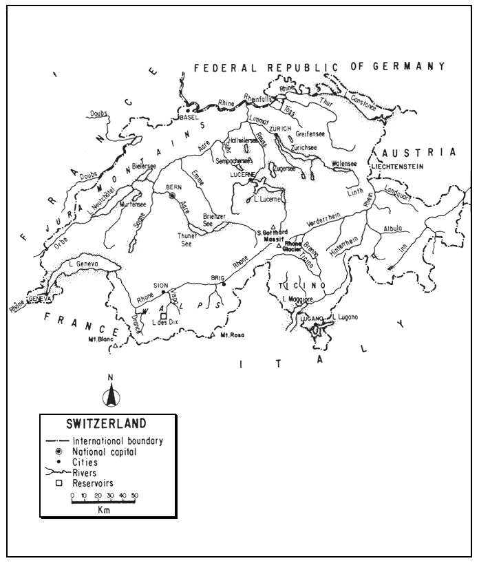
Landlocked in west-central Europe, the Swiss Confederation occupies the summit of the Continent, with drainage to four seas. Two-thirds mountainous and one-quarter “unproductive”, this small country has a diversity of attractive natural features: iceclad peaks, Alpine pastures, forested slopes, alluvial plains, rushing rivers, and a complex of large sub-Alpine lakes.
With its population engaged primarily in specialized manufacturing, commerce, and services, demands on its water resources are relatively small. True, its use of water for development of hydroelectric power is intense, but with respect to fisheries this is largely compensated for by the increase in static water (reservoirs) and stream regulation.
Switzerland's large lakes, mountain tarns, and many rivers provide habitat for cold water fishes, especially coregonids and salmonids, and for both commercial and recreational fishing. As a result of the country's subdivision into rather autonomous cantons, the management of fisheries differs in different regions, but coordination by Federal authority serves to promote their development.
Although stayed by a policy of good land and water use, environmental deterioration and multiple-use of surface waters may bring about subsidence in commercial fisheries. Interest in sport fisheries will, however, rise, accompanied by a small increase in cold water aquaculture.
| 1. | AREA: | 41 293 km2 | |
| 2. | POPULATION: | 6 387 000 (est. 1990) | Density: 155 inh/km2 |
| 3. | PHYSICAL GEOGRAPHY | ||
Switzerland is situated between 45°49'09" and 47°48'35"N latitudes and 05°57'24" and 10°29'36"E longitudes.
Roughly ovate, its greatest length (E–W) is 348 km and its greatest breadth (N–S) is 220 km. Its altitudinal range is from 193 m (the surface of Lago Maggiore) to 4 634 m (Mt. Rosa). Its mean altitudinal range is 1 350 m, the highest of any European country.
A landlocked country, the Swiss Confederation is bounded on: the north by the Federal Republic of Germany for 345.7 km; the east by Liechtenstein for 41.1 km and by Austria for 165.1 km; the southeast and south by Italy for 734.2 km; and the west and northwest by France for 571.8 km - a total of 1 857.9 km1.
Switzerland consists of three natural regions, roughly paralleling each other, NNE-SSW:
(i) The Jura. This folded mountain system of ridges and valleys consists primarily of stratified limestone well covered with conifers and beeches. It possesses few streams and much of the drainage is underground. Seldom over 900 m, it rises to 1 680 m.
(ii) The Alps. The Swiss Alps constitute the most imposing section of Switzerland. They consist of Pre-Alps (to about 2 700 m) which are primarily of limestone, lack glaciers, and are covered with snow only in winter. South of the Pre-Alps are the High Alps with peaks 3 000 to 4 600 m and U-shaped glacial valleys. Above 2 500 or 3 000 m these mountains have eternal snows. The highest peaks are of hard crystalline rocks (granites and gneisses) but the lower ones, like the Pre-Alps, are limestone. It is in the Alps that the major Swiss rivers arise.
(iii) Midland or Central Plateau. About 290 km long, 50 km wide, and averaging 457 m in height, this series of valleys and hills begins in the southwest rising from Lake Geneva and ends in the northeast under Lake Constance. Its gently sloping surface is covered with glacial debris and alluvial soil. Along the foot of the Jura is a long flat valley with several lakes draining into the Aare River. The consequent streams from the Alps cut deep valleys into the Midlands. This is the heartland of Swiss farming and industry.
Not only are the effects of past glaciation evident in Switzerland's physiography, it still has over 1 000 glaciers occupying about 1 556 km2. Nineteen of these are over 10 km2 in area. The most typical are valley glaciers including the 86.8-km2 Great Glacier of Aletsch, the largest in Europe.
In this humid country, physical and chemical weathering is constant, creating soils of crystalline origin (Alps), limestone (Jura) and colluvial (Midlands). Soils in the Jura and Alps are thin and leached, those in the heartland are more fertile.
About 55 percent of the forests are in the Alps, 25 percent on the Plateau, and 20 percent in the Jura. Up to 1 200 m, the cover is mainly broad-leafed deciduous forest: oak, maple, beech and hornbeam. Between 1 200 and 2 000 m, the forest cover is fir, larch and pine. Alpine pastures are also found above the deciduous forest, with grass growing to about 3 000 m and Alpine flora above 2 000 m. An exception to this general pattern is found in the southernmost area, the Ticino, which is shared with Italy. Here one finds Mediterranean vegetation: chestnut, cypress, and groves of lemons and oranges.
4. CLIMATE
The climate of Switzerland varies remarkably with altitude, wind pattern, and relief rather than with latitude, which is only 2°. North of the Alps, the climate is temperate, often cool and rainy with winter averages near freezing and summer temperatures rarely above 21°C. Average annual temperatures range from 7°C on the Plateau to 1.5°C in the mountains. Frost occurs above 1 800 m in the Alps and Jura. South of the Alps, the canton of Ticino has a warm Mediterranean climate, frost being almost unknown.
The average annual precipitation (including snow) is 1 470 mm. Precipitation varies with the topography. It is over 3 200 mm annually in the high mountains, about 1 100 mm in the Midlands, and only 600–700 mm in some Alpine valleys. Above 3 500 m, most of the precipitation is in the form of snow.
Snowline in the western Alps is at about 2 700 m, and in the drier eastern Alps at about 3 200 m. On the north side of the Alps, the dry hot wind, the “Föhn”, melts the snow early, thus contributing to the flood of Alpine streams.
5. HYDROGRAPHY AND LIMNOLOGY1
Table 5 indicates that the total inland water of Switzerland is 1 520 km2 or 3.7 percent of the country's total area. The Switzerland, Bundesamt für Statistik (1979) lists the inland water area of the country as 141 558 ha of lakes and 11 128 ha of rivers, totalling 1 526.86 km2.
According to Van der Leeden (1975), the average annual runoff from rainfall in Switzerland is 1 000 mm or 42 000 million m3 and in addition, 8 000 million m3 are received from upstream countries. ECE (1978) lists the approximate average runoff in Switzerland as 42 500 million m3 annually and a flow of 7 500 million m3 received from upstream countries. They agree, therefore, on a total annual river discharge of 50 000 million m3 leaving the country.
Situated on the summit of Europe, the drainage of Switzerland belongs to the continent's four major rivers, all of which originate near the St. Gotthard Massif in the Alps. Hydrographically, this water tower of Europe consists of three great river valleys (the Rhône, Rhine and its tributary the Aare) lying to the north of the main chain of the Alps and including within their basins the area of the Central Plateau. The southernmost area of the country, the Ticino, drains into the Po system. In the extreme east, a small portion drains into the Danube through the Inn or Engadine Valley. These major hydrographic basins are shown in Table 1.
Table 1
The major hydrographic basins of Switzerland
| River basin | Swiss basin area | Mean annual discharge | Drainage | ||
| km2 | Percent | m3/sec | |||
| Rhine | 27 956 | 67.7 | 1 028 | Atlantic (North Sea) | |
| Rhône | 7 556 | 18.3 | 315 | Mediterranean | |
| Po | 3 964 | 9.6 | several brooks | Adriatic | |
| Danube | 1 817 | 4.4 | 52 | Black Sea | |
Source: Framji and Mahajan (1969); Switzerland, Bundesamt für Statistik (1981)
5.1 Rivers (Flüsse/Fleuves)
Switzerland's rivers have a total length of about 30 000 km (Switzerland/EIFAC, 1974; 1979). Their surface area has been calculated as totalling 11 128 ha (Switzerland, Bundesamt für Statistik, 1979).
The principal rivers of the country, including length, basin area and discharge, are listed in Table 2.1
River discharge is a function of both rainfall and snowmelt. Alpine rivers have floods in late spring and early summer while Midland rivers have floods after rainstorms, mainly in summer. Thus, the Rhine's peak flow is in June/July and its minimum in January. The Rhône's monthly maximum is in July, its minimum in February and March. There is less retardation of runoff on the southern slopes of the Alps where the mountains are steep. In the Jura there is some percolation through the chalk, and many of the valleys having glacial till are also permeable. The lakes act as equalizing basins so that variations in river flow are smaller than in many other countries. Furthermore, artificial embankments have been erected along many rivers to accommodate excess water accumulated from rainfall and snowmelt.
The major rivers of Switzerland are described below.
5.1.1 Atlantic drainage
Rhine. The Rhein or Rhin, as it is called in Switzerland, travels from its source to its mouth in the North Sea for 1 350 km passing through or being a border for Switzerland, Liechtenstein, Austria, Germany, France, and the Netherlands en route. Arising in the eastern part of the Swiss Alps by the junction of two mountain rivers, the Vorderrhein and Hinterrhein, it flows northerly as an Alpine river (low water in winter and spate in spring or summer) to enter Lake Constance. En route it forms Switzerland's eastern border with Liechtenstein for 41.1 km and also the eastern border with Austria for 23 km. It is partly regulated during this course, and the Lake also acts as a regulator. Upon leaving the Lake at Konstanz, it widens into the Untersee and then flows westward for 165 km to Basel where it turns north and leaves Switzerland. During its course of 375 km in Switzerland, it descends from 2 200 to 200 m. Below Lake Constance, it changes in character, becoming narrow and plunging between rocks and over rapids including the Rheinfalls, the most powerful falls in Europe: 150 m wide and 21 m high.
Table 2
Principal rivers of Switzerland
| River | Lengtha | Basin area | Mean annual discharge | |||
| km | km2 | m3/sec | Period | Station | ||
| Rhine/Rhein/Rhin | 375.0 | 36 494 | 1 032.0 | 1808–1982 | Basel | |
Vorderrhein | 67.5 | 1 514 | 32.5 | 1962–82 | Ilanz | |
Hinterrhein | 57.3 | 1 693 | -- | -- | -- | |
Albula | 36.0 | 950 | 15.8 | 1926–82 | Tiefencastel | |
Lanquart | 42.6 | 618 | 24.8 | 1926–82 | Felsenbach | |
Thur | 125.0 | 1 724 | 46.8 | 1904–82 | Andelfingen | |
Töss | 57.6 | 442 | 7.8 | 1921–82 | Neftenbach | |
Glatt | 36.0 | 416 | -- | -- | -- | |
Aare | 295.2 | 17 779 | 560 | 1935–82 | Untersiggenthal | |
Lütschine | 27.0 | 380 | 18.7 | 1924–82 | Gsteig | |
Kander | 43.5 | 1 126 | -- | -- | -- | |
Simme | 52.9 | 594 | 11.7 | 1921–82 | Oberwil | |
Saane/Sarine | 128.5 | 1 892 | 53.7 | 1949–82 | Laupen | |
Sense | 45.8 | 433 | 8.50 | 1928–82 | Thörishaus | |
Orbe | 57.0 | 488 | 12.3 | 1973–82 | Orbe | |
Broye | 86.0 | 854 | -- | -- | -- | |
Areuse | 31.0 | 393 | 12.3 | 1923–82 | Champ du Moulin | |
Schüss | 40.5 | 282 | -- | -- | -- | |
Emme | 80.1 | 983 | 19.2 | 1922–82 | Wiler | |
Wigger | 39.7 | 380 | -- | -- | -- | |
Suhr | 34.1 | 371 | -- | -- | -- | |
Reuss | 158.5 | 3 425 | 141 | 1935–82 | Mellingen | |
Sarner Aa | 9.4 | 338 | 10.1 | 1934–82 | Sarnen | |
Kleine Emme | 58.3 | 477 | 18.2 | 1978–82 | Littau | |
Linth-Limmat | 140.0 | 2 416 | 97.1 | 1938–82 | Zürich | |
Sihl | 73.1 | 341 | 6.80 | 1938–82 | Zürich (Sihlhölzli) | |
Ergolz | 27.2 | 301 | 3.71 | 1934–82 | Liestal | |
Birs | 73.0 | 924 | 15.2 | 1917–82 | Münchenstein | |
| Rhône/Rhone | 264.0 | 10 403 | 322.0 | 1946–82 | Aire | |
Vispa | 40.2 | 787 | 16.3 | 1965–82 | Visp | |
Borgne | 29.4 | 385 | -- | -- | -- | |
Drance | 43.3 | 678 | 2.36 | 1957–82 | Châble | |
Doubs | 74.3 | 1 310 | 33.0 | 1921–82 | Ocourt | |
Allaine | 28.0 | 319 | -- | -- | -- | |
| Ticino | 91.0 | 1 616 | 69.3 | 1921–82 | Bellinzona | |
Brenno | 34.4 | 404 | 4.53 | 1961–82 | Loderio | |
Moësa | 43.8 | 477 | -- | -- | -- | |
Maggia | 55.8 | 926 | 3.84 | 1982 | Bignasco | |
Tresa | 13.4 | 754 | 24.8 | 1923–82 | Ponte Tresa | |
| Poschiavino | 24.6 | 238 | 6.04 | 1931–82 | Le Prese | |
| Mera | 21.1 | 190 | -- | -- | -- | |
| Rambach | 13.7 | 188 | -- | -- | -- | |
| Inn/En | 104.0 | 2 150 | 54.1 | 1970–82 | Martina | |
Source: Statistisches Jahrbuch der Schweiz/Annuaire statistique de la Suisse 1984 (The latest Jahrbuchs (1989, 1990) seen by the author do not include this detail)
Aare/Aar. The major affluent of the Rhine in Switzerland is the 295-km Aare, the longest river completely within the country. Arising from Grimsel Lake, fed by glaciers, it flows generally northwest through the Brienzersee and Thunersee to Bern (where it is dammed to form the Wohlersee). Farther on, it is diverted into the Bielersee, and then proceeds northeasterly to join the Rhine near Coblenz. It is larger than the Rhine at this point.
5.1.2 Mediterranean drainage
Rhône. The third largest drainage system in Switzerland rises in the Rhône Glacier in the Alps and proceeds generally westwardly and then northwesterly to enter Lake Geneva. Its upper area is a mountain torrent, but from the junction of the Massa at Brig it flows on an alluvial plain, then passes through Lake Geneva (which regulates its flow) for 72 km, and enters France 20 km below the lake. Here its minimum flow is in January–February; its maximum in July. The Rhône's total length from source to its mouth in the Mediterranean is 812 km.
Ticino. The Ticino River rises in the southern Swiss Alps and flows south for 91 km to enter Lake Maggiore. Its monthly mean minimum flow is in February; its monthly maximum flow is in June. A number of other Swiss rivers (see Table 2) enter its drainage which ultimately reaches the Po which debouches in Italy in the Adriatic Sea.
In addition to the Ticino, there are some minor rivers such as the Poschiamo and Mera which are also in the Po drainage, and the Rambach which joins the Adige drainage to empty into the Adriatic.
5.1.3 Black Sea drainage
Inn/En. The last of the foremost drainages in Switzerland is that of the Inn, which, like the Rhine rises in extreme eastern Switzerland, but farther southwest. Starting in lakes near St. Moritz, the Inn follows the valley of the Engadine northeast for 104 km to Austria where it joins the Danube. Its mean minimum flow is in February; its major flow in May and June.
5.2 Lakes (Seen/Lacs)
There are 1 484 natural lakes in Switzerland: 1 358 in the Alps, 112 in the Midlands, and 14 in the Jura (Framji and Mahajan, 1969). Worldmark (1988) states that there are also about 12 900 smaller bodies of standing water in the country. The total lake area in Switzerland including reservoirs is listed at 1 415.58 km2 by Switzerland, Bundesamt für Statistik (1979).
Table 3 lists the 28 Swiss natural lakes over 0.5 km2 in area. The total area of these 28 lakes is 2 079.41 km2, but of this total only 1 289.01 km2 (62 percent) belong exclusively to Switzerland.
Switzerland is characterized by the presence of many large natural lakes including several shared with other countries: Geneva and Lac des Brenets shared with France, Constance shared with Germany and Austria, and Maggiore and Lugano shared with Italy.
Some of the lakes are tectonic, e.g., the Lac de Joux in the Jura which lies in a tectonically dammed syncline. The Lac de Brenets also in the Jura is a landslide lake. Most of the Swiss lakes, however, have been formed by glacial excavation or corrasion. The foot of the Alps where the large valleys leave the mountains is marked by especially large glacial lakes with terminal moraines.
Most of the large sub-Alpine lakes are deep, subject to thermal stratification in summer and winter and to turnover in autumn and spring. Most of these, although originally oligotrophic, are tending toward eutrophication - the cumulative effect of years of settlement and the highly augmented entrance of organic substances in recent years. Lake Brienz is one of the last large Swiss lakes still considered to be oligotrophic.
Some characteristics of the largest Swiss lakes, in addition to those shown in Table 3, follow.
Lake Geneva (Lac Léman or Genfersee). Shared with France (Switzerland's portion is 347.3 km2 or 60 percent), and acting as a regulator of the Rhone, it is the largest of the Alpine lakes. It is 72 km long, has a maximum width of 14 km, a mean depth of 152 m, and a retention time of 12 years. It is now considered to be eutrophic. Born at Morges, on the shores of Lake Geneva, it was at this famous lake that E.A. Forel (1841–1912) made most of his studies and formally christened the science of limnology.
Lake Constance/Bodensee/Konstanz. Situated in extreme northeastern Switzerland, Lake Constance, the third largest lake (after Geneva and Balaton) in Central Europe, is shared with Austria and the Federal Republic of Germany. Switzerland's portion is 173.2 km2 or a third of the lake's total area. Fed by the Rhine, the lake is divided into the main body, called the Obersee, a northwest area the Überlingersee, and a southwest extension below Konstanz called the Untersee or Lac Inferieur. The entire lake, with an area of 541.2 km2 is 62 km long and 13 km wide, has an average depth of 90 m, and an average volume of 48 340 million m3. There is a fluctuation in water level of about 160 cm. Its summer surface temperature is about 22°C, its minimum temperature about 3.7°. It can be considered as just dimictic. The German and Swiss Untersee is connected with the rest of the lake by a 3.2 km stretch of the Rhine. It has an area of 62 km2, is about 16 km long, has an average width of 4.8 km, an average depth of 28 m, and a maximum depth of 46 m.
Table 3
Principal natural lakes of Switzerland (over 0.5 km2)
| Name | Total areaa km2 | Altitude m | Maximum depth m |
| Geneva/Léman/Genferseeb | 581.3 | 372.0 | 310 |
| Constance/Bodenseec | 541.2 | 395.6 | 252 |
| Neuchâtel/Neunenburgersee | 217.9 | 429.4 | 153 |
| Lago Maggiore/Lac Majeurd | 212.3 | 193.5 | 372 |
| Lucerne/Vierwaldstättersee/Lac des Quatre Cantons | 113.6 | 433.6 | 214 |
| Zürichsee/Lac de Zuriche | 90.1 | 405.9 | 143 |
| Lago di Lugano/Luganerseef | 48.7 | 270.5 | 288 |
| Thunersee/Lac de Thoune | 48.4 | 557.7 | 217 |
| Bielersee/Lac de Bienne | 39.8 | 429.2 | 74 |
| Zugersee/Lac de Zoug | 38.3 | 413.6 | 198 |
| Brienzersee/Lac de Brienz | 29.8 | 563.7 | 261 |
| Walensee/Lac de Walenstadt | 24.1 | 419.1 | 150 |
| Murtensee/Lac de Morat | 23.0 | 429.2 | 46 |
| Sempachersee/Lac de Sempach | 14.5 | 503.8 | 87 |
| Hallwilersee/Lac de Hallwil | 10.3 | 449.0 | 47 |
| Greifensee/Lac de Greifen | 8.6 | 435.0 | 34 |
| Sarnersee/Lac de Sarnen | 7.5 | 469.0 | 52 |
| Ägerisee/Lac de Ageri | 7.2 | 724.0 | 82 |
| Baldeggersee/Lac de Baldegg | 5.3 | 463.0 | 66 |
| Silsersee | 4.1 | 1 797.0 | 71 |
| Pfäffikersee | 3.3 | 537.0 | 35 |
| Silvaplaner and Campfèrsee | 3.2 | 1 791.0 | 77 |
| Lauerzersee | 3.1 | 447.0 | 14 |
| Öschinensee | 1.1 | 1 578.0 | 56 |
| St. Moritzersee | 0.78 | 1 768.0 | 44 |
| Daubensee | 0.69 | 2 205.0 | -- |
| Lac des Brenetsg | 0.69 | 750.0 | 32 |
| Mauensee | 0.55 | 504.0 | 9 |
b Shared with France. Swiss portion is 347.3 km2 (60 percent)
d Shared with Italy. Swiss portion is 42.3 km2 (20 percent)
f Shared with Italy. Swiss portion is 30.7 km2 (63 percent)
g Shared with France. Swiss portion is 0.29 km2 (42 percent)
Source: Statistisches Jahrbuch der Schwiez/Annuaire statisque de la Suisse 1984
Once oligotrophic, there has been a progressive eutrophication of the lake since 1950, due primarily to untreated municipal waste containing sewage and detergents. About one-third of the eutrophication derives from agricultural practices. The main basin is now considered to be between meso- and eutrophic. Annual fish yields have increased with eutrophication but the composition of the major fish stocks in the Obersee has shifted from coregonids to cyprinids and perch (Hartman and Nümann, 1977). The fish catch in the Obersee during the 1970–74 period was divided as follows: Switzerland 41 percent; Federal Republic of Germany 41 percent, and Austria 18 percent (Deufel, 1975). According to Milway (1970) it has an annual yield of about 4 000 t of fish.
Lac de Neutchâtel/Neuenberguresee. Neutchâtel, the largest lake lying completely within Switzerland, lies east of the Jura in the Aare River drainage, fed by the Thiele or Zihl River. It has a length of 39 km and a width of 6–8 km. It can be called mesotrophic. Canals connect it with the 16-km long Bielersee (Lac de Bienne) and the 9-km long Murtensee (Lac de Morat).
Lago Maggiore/Lac Majeur. Only 20 percent (42.3 km2) of this sub-Alpine lake, lying south of the Alps in the Ticino (Po) drainage, belongs to Switzerland. The remainder, like Lago di Lugano di Lugano (see below) lies in Italy. The entire lake has a perimeter of 170 km, a length of 54 km, width of 10 km, mean depth of 175 m, and a volume of 37 100 million m3. It is now considered meso-eutrophic. (See section 5.2 in Italy for further description.)
Lago Lucerne/Vierwaldstättersee/Lac de Quatre Cantons. Commonly called Lake Lucerne, although the Luzernersee is but one of its four arms, this 38-km long lake, with a volume of 11.8 million m3, situated in central Switzerland is fed by the Reuss River, a major tributary of the Aare. It has a minimum water temperature of 4.3°C and is considered monomictic.
Zürichsee. This dimictic to warm monomictic lake, 40 km long, 4 km wide, with a mean depth of 51 m, also lies in the Aare drainage. Formerly fed directly by the Linth River, since 1827 it has been fed by the Linth Canal which emerges at the city of Zürich as the Limmat River. Like other Swiss lakes, the Zurichsee changed from an oligotrophic to eutrophic condition within the last 85 years, but has now improved decidedly with bypass of sewage water into its outlet.
Lago di Lugano/Luganersee. This very irregular lake, lying south of the Alps, drains through the Tresa River into Lago Maggiore. Sixty-three percent (30.7 km2) belongs to Switzerland; the rest is Italian. Its greatest length is 35 km, its greatest width 3 km, its average depth is 130 m and its volume 6.5 km3. It has a minimum temperature of 5.2°C and is monomictic. Like the other sub-Alpine lakes, it is becoming more eutrophicated now being considered eu-hypertrophic. Fish such as the landlocked shad or agone (Alosa fallax lacustris) have diminished.
Thunersee/Lac de Thoune. Largest of the lakes on the Aare is the Thunersee, 18.5 km long and 2 to 2.8 km wide. Occupying the terminal basin of a glacier, it is separated by a lacustrine delta from the smaller Brienzersee (Lac de Brienz), 14.5 km long and 2.4 km wide. Over a 40-year period, the Thunersee has gradually evolved from oligotrophic to mesotrophic, but the yield is still almost completely of coregonids.
Bielersee/Lac de Bienne. Situated at the foot of the Jura range, the Bielersee is fed by water from the Aare and also receives water from Lac de Neuchâtel. It is 12 km long and 4 km wide. It is also eu/mesotrophic.
Zugersee/Lac de Zoug. The tenth largest Swiss lake is the eutrophic Zugersee, 14.5 km long and 4 km wide. Lying directly north of Lake Lucerne, it is in the Reuss (Aare) drainage.
5.3 Reservoirs (Speicherseen or Stauseen/Lacs d'accumulation)
Switzerland has more than 70 large reservoirs, most of which serve for hydroelectric production. Forty-five of these reservoirs totalling 93.12 km2 in area are listed in Table 4. Twelve of these waters are natural lakes converted into reservoirs by control structures enabling greater water storage.
Most of the reservoirs are situated at much higher altitudes than Switzerland's major lakes, and are less productive than the natural lakes. Especially noteworthy among them is the Lac des Dix at an elevation of 2 364 m on a tributary of the Rhône in southern Switzerland, which was filled in 1966. Its 284-m gravity dam is the greatest piece of hydroelectric engineering in the country and has one of the highest heads in the world. Its capacity of 400 million m3 is almost twice as large as that of its nearest Swiss competitor. Other especially high dams are that of the Zervreilasee (151 m) in the Grisons, and the 156-m dam of the Lac de Tseuzier or Zeusier near Sion.
Aside from their partial use for fishing, the fact that these reservoirs hold back summer runoff for winter use helps reduce water pollution during periods of low natural discharge. An amendment to the Swiss constitution provides for Federal regulation for maintenance of minimal stream flows.
5.4 Canals (Kanäle/Canaux)
Switzerland has some canalized river stretches and a number of cross-connexions between lakes or rivers, but no canal system of consequence.
Table 4
Principal reservoirs of Switzerland
| Name | Area (km2) | Max. elevation (m above sea level) | Useful capacity (million m3) |
| Sihlsee | 10.85 | 889.3 | 91.8 |
| Lac de la Gruyère | 9.60 | 677.0 | 180.0 |
| Lac de Joux et Brenet (N) | 9.56 | 1 005.0 | 30.0 |
| Schiffenensee | 4.25 | 532.0 | 35.5 |
| Wägitaler See | 4.18 | 900.0 | 76.1 |
| Lac des Dix | 4.03 | 2 364.0 | 400.0 |
| Klöntaler See (N) | 3.29 | 846.8 | 39.8 |
| Lac d'Emosson | 3.27 | 1 930.0 | 225.0 |
| Grimselsee (N) | 2.72 | 1 908.7 | 93.9 |
| Lac de Mauvoisin | 2.08 | 1 961.5 | 180.0 |
| Lungerer See (N) | 2.01 | 688.7 | 50.0 |
| Lago de Poschiavo (N) | 1.98 | 962.3 | 15.1 |
| Lac de Salanfe | 1.85 | 1 925.0 | 40.0 |
| Lai da Sta. Maria | 1.77 | 1 908.0 | 67.0 |
| Mattmarksee | 1.76 | 2 197.0 | 100.0 |
| Lago di Vogorno | 1.68 | 470.0 | 84.4 |
| Zervreilasee | 1.61 | 1 862.0 | 100.0 |
| Lac de l'Hongrin | 1.60 | 1 255.0 | 52.1 |
| Lago Bianco (N) | 1.50 | 2 234.4 | 18.4 |
| Lago Ritom (N) | 1.49 | 1 850.1 | 47.5 |
| Oberaarsee | 1.46 | 2 303.0 | 56.0 |
| Lai da Marmorera | 1.41 | 1 680.0 | 60.0 |
| Lac de Moiry | 1.40 | 2 249.0 | 77.0 |
| Limmerensee | 1.36 | 1 857.0 | 92.0 |
| Göscheneralpsee | 1.32 | 1 792.0 | 75.0 |
| Lago di Luzzone | 1.27 | 1 591.0 | 87.6 |
| Lago da Albigna | 1.13 | 2 162.6 | 68.6 |
| Lago di Sambuco | 1.11 | 1 461.0 | 62.0 |
| Lac da Nalps | 0.91 | 1 908.0 | 44.5 |
| Sufnersee | 0.90 | 1 401.0 | 18.3 |
| Lac de Tseuzier | 0.85 | 1 777.0 | 50.0 |
| Lac da Curnera | 0.81 | 1 956.0 | 40.8 |
| Lac de Monsalvens | 0.74 | 800.8 | 11.0 |
| Lago di Naret (N) | 0.73 | 2 310.0 | 31.1 |
| Gigerwaldsee | 0.71 | 1 335.0 | 33.4 |
| Lac de Moron | 0.69 | 716.0 | 15.8 |
| Räterichsbodensee | 0.67 | 1 767.0 | 25.0 |
| Gelmersee (N) | 0.64 | 1 850.2 | 13.4 |
| Lac des Toules | 0.61 | 1 810.0 | 20.0 |
| Griessee | 0.60 | 2 386.5 | 18.0 |
| Davoser See (N) | 0.59 | 1 558.7 | 11.3 |
| Lac du Vieux Emosson | 0.55 | 2 205.0 | 13.5 |
| Lago di Lucendro (N) | 0.54 | 2 134.5 | 25.0 |
| Melchsee (N) | 0.54 | 1 893.3 | 3.0 |
| Lac de Cleuson | 0.50 | 2 186.0 | 20.0 |
(N) Natural lake converted for storage
Source: Statistisches Jahrbuch der Schweiz/Annuaire statistique de la Suisse 1984
6. LAND AND WATER USE
Table 5
Pattern of land use in Switzerland, 1986
| Percent | |
| Arable and permanent crops | 9.9 |
| Permanent pasture | 39.0 |
| Forests and woodlands | 25.5 |
| Other land | 21.9 |
| Inland water | 3.7 |
| Total | 100.0 |
Source: 1987 FAO Prod.Yearb., 41 (Publ. 1988)
In spite of its mountainous terrain, agriculture is important in Switzerland, and great efforts are made to use even steep rocky slopes for this purpose. Cereals are grown but the climate is mostly too wet for good production. Fodder crops, fruit, and the vine are major products. The livestock industry is important with emphasis on dairy products. Switzerland is a country of small holdings, preventing agricultural use on a large scale, and irrigation on a large scale is not practised. There is only some simple irrigation using torrents and in some areas under adverse climatic conditions. Only about 0.6 percent of the country is irrigated (1986). Fertilizer use is small.
Forests (about 75 percent coniferous) which cover about one-quarter of Switzerland are well used throughout the country which ranks about sixteenth in European forest production. An exemplary forest law forbids the reduction of woodlands, and many areas are planted with trees to protect against landsides, avalanches, and to slow down runoff.
Mining is of almost no importance. Rock, salt, sand and gravel are produced.
Switzerland's “white gold” is hydroelectricity. Its waters are used intensively for its production using the large flows from lakes and of rivers on the plateau, and from high head reservoirs and natural lakes in the mountains. There are more than 400 large hydroelectric plants in the country and numerous low-pressure plants on the rivers. Of its total installed capacity in 1978, about one-third was in run of the river plants and two-thirds in accumulation plants. In 1987, of a total installed capacity of 15 250 000 kW, hydroelectric power represented 75.5 percent (11.51 million kW). Thermal power represented only 5.2 percent, and nuclear power 19.3 percent.
Next to services, industry is the most important economic activity in Switzerland. The absence of major mineral resources, such as coal and iron, has conditioned the type of industry toward production of high value specialized products which are export oriented. In general order of dominance are metallurgy, machinery and equipment, chemicals, drugs, watch manufacturing, textiles, clothes, and food. Hydroelectric power furnishes most of the energy, and in Switzerland manufacturing is a relatively clean industry. Furthermore, it is well distributed over the country without great pollutionridden industrial concentrations. There are, however, some high concentrations of effluent, especially near Basel where large quantities of chemical waste, together with cooling waters, are discharged into the Rhine.
Switzerland is threaded with an excellent system of railroads and paved highways making any area easily accessible. For a mountainous area, it has a high road density (1.7 km/km2 in 1986), and one of the highest passenger car ownerships in Europe (429 vehicles per 1 000 in 1987). It has 12 navigable lakes but only about 65 km of navigable waterways, e.g., sections of the Rhine below Lake Constance.
There has been a considerable regulation of both rivers and lakes for flood control and to avoid sedimentation and erosion. Thus, rivers have been canalized to prevent floods on flat lands. The Rhine and Rhône have been partially embanked, and rivers have been diverted into lakes to prevent sedimentation, e.g., the Aare.
About two-thirds of the public water supply comes from underground water with which Switzerland is well provided. Difficulties in transport of surface supplies in the cantons and the competing use of water for hydroelectric power have lessened demands for surface waters although both lakes and rivers are used for public supply.
Switzerland is considered to be about 60 percent urban and 40 percent rural, and about 30 percent of the people live in the country's five largest cities. Most communities of any appreciable size are on the shores of lakes or banks of sizeable rivers. This has influenced the state of sewage treatment, sanitary sewer systems having come rather late. The very high domestic water consumption by the Swiss makes sewage rather weak and modern treatment has increased rapidly. Nevertheless, both lakes and rivers still receive considerable domestic effluent. With respect to total water use, industry with 67 percent and public water supply with 23 percent use most of the water. The use of water for commercial fisheries and aquaculture is minor (see section 7) but the policy of the government has been to support fishing as a useful and fundamental way of life. Protection of fish farm waters is included in the categories requiring specific conditions of water quality.
Per caput consumption of fish has ranged from 5.1 kg/year in 1976 to 7.4 kg in 1986, but 85–90 percent of the fish eaten is imported.
Switzerland's complex of Alpine mountains, beautiful lakes, clear streams, and picturesque cities, in addition to an excellent system of transport and an emphasis on environmental considerations has made tourism a major industry, accounting for about 10 percent of the country's receipts. Angling has not, however, been emphasized in tourist literature, where other water sports seem to receive just as much emphasis.
7. FISH AND FISHERIES
Exploited fish species in Switzerland include: European eel (Anguilla anguilla), landlocked shad (Alosa fallax lacustris), brown trout (Salmo trutta), char (Salvelinus alpinus), coregonids (Coregonus spp.), grayling (Thymallus thymallus), pike (Esox lucius), several species of cyprinids, especially bream (Abramis brama), roach (Rutilus rutilus), tench (Tinca tinca), and common carp (Cyprinus carpio), burbot (Lota lota), European perch (Perca fluviatilis) and pike-perch (Stizostedion lucioperca). In addition to these native European fishes, the introduced rainbow trout (Oncorhynchus mykiss) is widely distributed, and two other North American fishes, the brook trout (Salvelinus fontinalis) and lake trout (S. namaycush), are present in some waters.
7.1 Capture Fisheries
As has been customary in this series describing European inland fisheries, a table has been included showing the inland fishery catch as compiled by FAO from data furnished by the country involved. Table 6 illustrates the “catch” in Switzerland during the 1965–87 period as recorded by FAO and amended by the author. However, it must be said at the outset that the original FAO presentation is highly misleading. Although no distinction was made in the FAO statistics between fish derived by capture and those produced through aquaculture (FAO's normal procedure to date) it is obvious from other information that most, if not all, of the listed catch came from commercial fishing. Note, for example, that although the largest tonnage of trout listed by FAO for any one year was 272 t in 1984, we know from other sources that cultivated trout production in Switzerland was already about 1 000 t annually by 1980, and was in fact 1 023 t in 1984 (see section 7.2).
An even more serious error in the FAO table, however, lies in the complete misidentification of a species group. In addition to the categories of “pike”, “European perch” and “trouts”, the FAO Yearbooks listed three other categories in the Swiss catch: “Freshwater fishes, nei”, “European whitefish (Coregonus albula)”, and “whitefishes, nei (Coregonus spp.)”. From various evidence, particularly the original two-language version of a table in the Statistiches Jahrbach der Schweiz 1979, it is apparent that the FAO Yearbook's “Coregonus albula” probably represented more than one species of coregonid (Family Coregonidae), and its “whitefishes, nei” undoubtedly represented several species of cyprinids (Family Cyprinidae), i.e., the fishes known generally in French as “poissons blanc” and in German as “Weissfische”, rather than coregonids1. This view of the author has been corroborated by Switzerland/EIFAC (1989). Because of these and possibly other mistakes, estimates, and misinterpretations in the FAO Yearbooks, a much better picture can be obtained by direct reference to publications by the Swiss Government.
Table 6
Nominal catches by species in the waters of Switzerland, 1965–87 (in tons)
| Pike | European perch | Freshwater fishes, nei | European whitefish | “Whitefishes” neib | Troutsnei | Total | ||||||
| 1965 | - | - | 2 700 | - | - | - | 2 700 | |||||
| 1966 | - | - | 3 000 | - | - | - | 3 000 | |||||
| 1967 | - | - | 3 000 | - | - | - | 3 000 | |||||
| 1968 | - | - | 3 500 | - | - | - | 3 500 | |||||
| 1969 | - | - | 3 500 | - | - | - | 3 500 | |||||
| 1970 | 100 | a | 1 100 | a | 0 | 500 | a | 600 | a | 100 | a | 2 400 |
| 1971 | 100 | a | 1 300 | a | 0 | 600 | a | 700 | a | 100 | a | 2 800 |
| 1972 | 100 | 1 700 | 0 | 700 | 900 | 200 | 3 600 | |||||
| 1973 | 100 | 1 700 | 0 | 700 | 900 | 200 | 3 600 | |||||
| 1974 | 76 | 1 824 | 19 | 741 | 912 | 228 | 3 800 | |||||
| 1975 | 78 | 1 887 | 21 | 762 | 918 | 234 | 3 900 | |||||
| 1976 | 79 | 1 900 | 20 | 764 | 917 | 235 | 3 915 | |||||
| 1977 | 80 | 1 950 | 22 | 771 | 921 | 238 | 3 982 | |||||
| 1978 | 75 | 1 811 | 20 | 743 | 940 | 231 | 3 820 | |||||
| 1979 | 74 | 1 908 | 29 | 734 | 911 | 234 | 3 890 | |||||
| 1980 | 70 | 1 711 | 23 | 690 | 805 | 201 | 3 500 | |||||
| 1981 | 74 | 1 781 | 24 | 721 | 835 | 241 | 3 676 | |||||
| 1982 | 77 | 1 870 | 25 | 757 | 877 | 253 | 3 859 | |||||
| 1983 | 76 | 1 880 | 26 | 787 | 879 | 269 | 3 917 | |||||
| 1984 | 74 | 1 892 | 28 | 810 | 909 | 272 | 3 985 | |||||
| 1985 | 81 | 2 102 | 29 | 790 | 1 111 | 270 | 4 383 | |||||
| 1986 | 73 | 2 250 | 31 | 800 | 1 300 | 271 | 4 725 | |||||
| 1987 | 75 | 2 001 | 29 | 901 | 1 549 | 252 | 4 807 | |||||
a Statistics estimated or calculated by FAO
b Not Coregonus, but miscellaneous Cyprinidae (see text)
- this category not listed this year
Source: 1965–69 Yearb.Fish.Stat.FAO, 36 (Publ. 1974)
1970–83 FAO Fish.Dept. Fishery Statistical Database (FISHDAB)
1984–87 Yearb.Fish.Stat.FAO, 64 (Publ. 1989)
Studies on harvest by species are compiled yearly by the Swiss cantonal agencies. The Federal fishery agency of Switzerland then collects these data and issues a national harvest statistic on the 20 major Swiss lakes every two years. One of the most recent compilations is shown in Table 7 which shows the average catch of both commercial and sport fisheries in 20 Swiss lakes during the 1981–86 period. Another table (Table 8) provides additional data on the same 20 lakes: their yield and the percentage of important fish categories in the catch of each lake. It is true that only 20 lakes are represented, but these comprise not only the most important lakes in the country for commercial fishing but constitute about 90 percent of Switzerland's lake water.
Both the harvest from these lakes and the yield of species groups has varied over the year. For example, during the 1972–79 period, a compilation of catch data on 18 Swiss lakes, constituting 84 percent of all static water in Switzerland, indicated a harvest of 33 percent coregonids (true whitefishes), 25 percent cyprinids, 39 percent perch, and only 3 percent for all other species (Statistiches Jahrbuch der Schweiz 1979). It is quite obvious, nevertheless, that the first three groups (coregonids, cyprinids and European perch) are the most important groups which are harvested in Switzerland's lakes. Furthermore, figues in both Staub (1987, Figure 7) and Müller (1988, Figure 1) demonstrate that this has been true since at least 1967.
Table 7
Average annual yield of commercial and sport fisheries in 20 Swiss lakes, 1981–86
| Lake (without foreign parts) | Total (kg) | Bream | Carp | Tench | Other cyprinids | Pike | Catfish | Turbot | European perch |
| Genevaa | 404 824 | 229 | 1 544 | 162 546 | 2 504 | 1 174 | 192 374 | ||
| Neuchâtel | 517 221 | 30 258 | 1 501 | 643 | 188 007 | 5 646 | 216 | 388 | 135 128 |
| Constance | 594 025 | 51 883 | 309 | 388 | 20 085 | 4 800 | 3 | 1 277 | 274 437 |
| Lucernea | 379 851 | 5 737 | 28 | 195 | 64 911 | 4 078 | 3 485 | 11 260 | |
| Zurich | 290 479 | 14 617 | 550 | 897 | 113 243 | 8 084 | 2 335 | 61 283 | |
| Thuna | 43 475 | 3 | 10 | 135 | 270 | 46 | 146 | ||
| Maggioreb | 172 715 | 25 | 7 312 | 17 213 | 12 406 | 1 080 | 12 881 | ||
| Biela | 117 052 | 7 036 | 157 | 39 625 | 3 084 | 914 | 12 966 | ||
| Zug | 106 174 | 6 170 | 330 | 189 | 59 709 | 1 470 | 1 174 | 11 375 | |
| Luganob | 32 421 | 444 | 870 | 20 987 | 247 | 1 122 | 5 716 | ||
| Brienza | 29 243 | 1 | 145 | 67 | 99 | 16 | |||
| Walenstadt | 44 003 | 73 | 3 | 2 | 2 880 | 1 032 | 2 450 | 4 424 | |
| Murten | 60 552 | 13 757 | 166 | 245 | 30 207 | 2 874 | 1 611 | 18 | 10 563 |
| Sempach | 77 729 | 4 117 | 92 | 777 | 6 694 | 2 308 | 186 | 5 660 | |
| Hallwil | 20 665 | 328 | 62 | 143 | 865 | 1 120 | 14 | 1 443 | |
| Joux | 21 286 | 21 | 2 177 | 2 649 | 2 | 1 861 | |||
| Sarnen | 25 250 | 32 | 7 906 | 840 | 244 | 1 228 | |||
| Aegeri | 9 548 | 31 | 1 697 | 1 596 | 55 | 1 450 | |||
| Baldegg | 11 247 | 1 386 | 382 | 48 | 2 878 | 549 | 10 | 1 939 | |
| Lungern | 10 480 | 1 815 | 548 | 24 | 258 | ||||
| Total | 2 968 240 | 135 366 | 4 121 | 13 504 | 743 725 | 56 172 | 1 830 | 16 097 | 746 408 |
| Lake (without foreign | Pike-perch | Eel | Whitefish (coregonids) | Trout (Salmo trutta) | Other trout | Char | Grayling | Other fishes |
| Genevaa | 11 119 | 6 278 | 3 399 | 23 657 | ||||
| Neuchâtel | 4 | 32 | 144 959 | 8 375 | 2 045 | 19 | ||
| Constance | 1 081 | 7 152 | 227 864 | 2 034 | 1 364 | 289 | 796 | 263 |
| Lucernea | 87 | 1 186 | 265 447 | 2 089 | 44 | 21 078 | 184 | 42 |
| Zurich | 102 | 568 | 85 415 | 2 744 | 82 | 386 | 70 | 103 |
| Thuna | 41 250 | 205 | 1 198 | 210 | 2 | |||
| Maggioreb | 444 | 386 | 116 737 | 3 011 | 101 | 1 119 | ||
| Biela | 134 | 52 920 | 149 | 67 | ||||
| Zug | 1 335 | 21 241 | 444 | 2 727 | ||||
| Luganob | 450 | 527 | 5 | 1 517 | 10 | 526 | ||
| Brienza | 28 628 | 130 | 143 | 13 | 1 | |||
| Walenstadt | 12 | 30 483 | 1 302 | 73 | 1 223 | 41 | 5 | |
| Murten | 47 | 11 | 170 | 881 | 2 | |||
| Sempach | 3 | 70 | 57 586 | 180 | 4 | 30 | 22 | |
| Hallwil | 27 | 17 | 16 634 | 8 | 3 | |||
| Joux | 13 303 | 1 010 | 263 | |||||
| Sarnen | 1 | 217 | 14 727 | 55 | ||||
| Aegeri | 37 | 4 090 | 107 | 486 | ||||
| Baldegg | 87 | 362 | 3 538 | 67 | 2 | |||
| Lungern | 7 808 | 28 | ||||||
| Total | 2 333 | 12 046 | 1 143 924 | 30 614 | 1 569 | 33 127 | 1 333 | 26 073 |
b From 1982 on, without sport fishery
Source: Müller (1988) after Bundesamt für Umweltschutz (1988)
The Swiss Federal Office of Statistics (Europa, 1985) states that the total Swiss catch in 1980 was 3.5 thousand tons and 3.7 thousand tons in 1981. It will be noted that the FAO figures (Table 6) agree with these figure totals for these years. It is the confusion concerning “whitefishes” and the apparent lack of a record of aquacultural production which makes the table inadmisable. Once again, the reader seeking catch figures for Switzerland is advised to consult only official Swiss statistics.
Both the coregonids and the perch are desired species, as are trout, char, and pike. Cyprinids, such as bream and roach, sometimes caught in large quantities especially as by-catch, are generally disliked by the public.
7.1.1 Commercial fishing
Müller (1988) points out that the Swiss commercial fishery harvest (as evidenced by official tables) is about 90 percent of the total catch. Following Staub (1987a), he also indicates that circa 1987 there were 292 full-time fishermen and 193 part-time commercial fishermen in Switzerland. Using gillnets (both drifting and bottom) and traps, these men shared a total lake area of about 1 400 km2, including the Swiss portions of international waters. All of the 352 fishing establishments concerned with commercial net fishing in 1985 were located on lakes, except for a few professionals who fished on a section of the Rhine.
In order to limit fishing intensity and to support the existence of full-time fishermen, the number of commercial fishing permits per lake is closed, their number depending upon the size and productivity of the lake. Fishing pressure is also limited by the number and size of the nets and by closures during the spawning season of important species. Each fisherman has need of from 300 to 600 ha. It may be noted that the number of full-time fishermen has varied little during the 1968–87 period, having remained at about 300 (Staub, 1987a). There has been a diminution of the number of part-time fishermen and also in the number of fishing establishments, but fishing effort is still believed to be rather constant.
Fishery management in Swiss waters is the province of the cantons, 17 of which have lakes exploited commercially today. Only in international and privately owned waters does the Federal government have a hand. Aside from such regulations as have been cited above, fishery management is also carried out through stocking. Both the cantons and some of the commercial fishermen participate in this endeavour. Trout, coregonids, and pike are stocked extensively, but the catch of perch relies entirely on natural reproduction.
Although there have been some great fluctuations in catch, the net fishery of the great lakes of Switzerland produces about 2 600 t annually (Staub, 1987). The value of the 1984 harvest has been estimated at about Sw F 17 million (Staub, 1987a).
Commercial fishing is relatively unimportant in the entire Swiss economy, but locally caught fish do supply a considerable percentage of local needs, perhaps 15 percent.
7.1.2 Sport fishing
Widely distributed sport fish in Switzerland include: both brown and rainbow trout, grayling, char, pike, perch and eel. American brook trout (Salvelinus fontinalis) are found in some waters (e.g., the Areuse), and the American lake trout (S. namaycush) in some lakes.
Switzlerland/EIFAC (1974) estimated the annual sport catch in lakes and rivers to be about 950 t to 1 140 t.
Gaudet (1977) estimated the number of sport fishermen in Switzerland to be about 250 000. Müller (1988) has estimated that about 200 000 sport fishermen (about 3 percent of the total population) fish in Swiss lakes. He also estimates that sport fishing yields about 10 percent of the lake catch.
Management of sport fishing relies on regulation such as size limits, stocking, and stream and lake improvement. Fishing in private waters may require a fee and there is some free fishing.
Table 8
Average annual yield and important fish species of 20 Swiss lakes, 1981–86
| Lake | Yield kg/ha/year | Percentage of important fish categories |
| Geneva | 11.7 | Perch 48%, cyprinids 41% |
| Neuchâtel | 24.0 | Cyprinids 43%, whitefish 28%, perch 26% |
| Constance | 34.6 | Perch 46%, whitefish 38% |
| Lucerne | 33.4 | Whitefish 70%, cyprinids 17% |
| Zurich | 32.8 | Cyprinids 45%, whitefish 29%, perch 21% |
| Thun | 9.1 | Whitefish 95% |
| Maggiore | 40.8 | Whitefish 68%, cyprinids 14% |
| Biel | 29.9 | Whitefish 45%, cyprinids 40% |
| Zug | 27.7 | Cyprinids 63%, Whitefish 20% |
| Lugano | 10.6 | Cyprinids 69%, perch 18% |
| Brienz | 10.0 | Whitefish 98% |
| Walenstadt | 18.2 | Whitefish 69%, perch 10% |
| Murten | 26.5 | Cyprinids 73%, perch 17% |
| Sempach | 53.6 | Whitefish 74%, cyprinids 15% |
| Hallwil | 20.3 | Whitefish 80% |
| Joux | 22.3 | Whitefish 62%, pike 12%, cyprinids 10% |
| Sarnen | 33.1 | Whitefish 58%, cyprinids 31% |
| Aegeri | 13.3 | Whitefish 43%, cyprinids 18%, pike 17% |
| Baldegg | 21.4 | Cyprinids 42%, Whitefish 31%, perch 17% |
| Lungern | 52.1 | Whitefish 75%, cyprinids 17% |
| Total | 23.4 | Whitefish or coregonids 39%, cyprinids 30%, perch 25% |
Source: Müller (1988) after Bundesamt für Umweltschutz (1988)
7.2 Aquaculture
The principal species of fish cultivated commercially in Switzerland are rainbow and brown trout. Its total aquacultural production circa 1974 was 300 t, mostly of rainbow trout, according to Switzerland/EIFAC (1974). Brown (1977; 1983) also stated that the total production of both rainbow and brown trout in 1974 was about 300 t, and that a generally accepted estimate was about 270 t of rainbow and about 30 t of brown trout achieved by about 30 fish farmers1. Although most of the recent authors listing trout production in European countries do not mention Switzerland. Shaw, Shaw and Thomas (1981) have a table showing that annual production of rainbow trout in Switzerland was 400 t during the 1976–79 period, jumping to 1 500 t in 1980 and 1981.
The rainbow trout spawn in February and March and the brown trout in November–January. After spawning they are usually reared in concrete tanks to about 6 cm and then placed in earthern ponds or concrete raceways. Between one and two years are required to raise the trout to market size between 180 and 200 g. Pelletized food is used. All domestic production is sold alive and generally directly to the consumer. There are no exports.
There is also a considerable import of trout (far exceeding the local production), especially from Denmark, Italy and France.
In addition to commercial trout culture, there is a limited production for food of common carp (Cyprinus carpio). Following spawning in the spring, the fry are reared in earthen ponds with little feeding. It requires three or four years to attain the market size of 1.5 kg. The production, which is centered in western Switzerland, is sold live directly to the consumer. In 1975 there were only five farms in the country with a total yearly output of 2 t.
The above information (mostly from Brown, 1977; 1983) can be supplemented by statistics from Switzerland, Bundesamt für Statistik (1979). These indicate that in 1975, Switzerland had about 100 ponds for the cultivation of fish, totalling 4 814 ha, and employing (on full and part-time basis) about 1 854 people.
By 1984 there were 87 installations in Switzerland where fish were reared for consumption and about 124 devoted to rearing fish for repopulation. Most of the fish cultural units are on the Midland Plateau where the water quality is best for them. Aquacultural establishments utilized a surface of 550 000 m2 in natural waters and 110 000 m2 in artificial installations. The artificial installations for fish destined for consumption used 50 000 m2. In 1984, 1 023 t of trout and 138 t of other species of fish were produced in Switzerland for food: their value was about Sw F 15 million (Staub, 1987)1.
All of the commercially important fish, except European perch, are stocked to support the fisheries. In 1984 about 666 million alevins were stocked. Of these, 606 million were coregonids whose production is aided by the use of net cages equipped with lamps to attract zooplankton. About 28 million fish were raised to pre-summerling and summerling stage before stocking. Of these 9.8 million were brown trout.
8. OWNERSHIP, ADMINISTRATION, MANAGEMENT, INVESTIGATION AND AGREEMENTS2
8.1 Ownership and Availability
No information on ownership and availability of fishing rights (other than that given below) is available to the author.
8.2 Administration and Management
8.2.1 Federal level
The Department of Interior is the competent Federal authority with respect to Swiss fisheries. Within this administration, fisheries is handled by the Federal Office for the Protection of the Environment (OFPE), more particularly by the latter's Office of Fishery Inspection which is responsible for much of the Federal work in this sphere. This latter office ensures that laws and regulations laid down by the cantons in accordance with the Federal fishery law of 14 December 1973, as well as agreements on fishing in inter-cantonal waters conform to Federal law.
Fishing in Swiss border waters is under the jurisdiction of international commissions staffed by fishery experts and plenipotentaries from the bordering countries which ensure that international agreements are respected. (These international waters are those of the Rhine, the Bodensee and Untersee, and Italo-Swiss and Franco-Swiss waters. See also section 8.5.) Switzerland is represented by the Chief of the Division of Natural Sciences and Fisheries (which has a Fisheries Section) under the OFPE in collaboration with the authorities in the riparian cantons.
The Federal Office of Fishery Inspection is also responsible for organizing refresher courses for the cantonal fish wardens, and issuance of information for the cantonal fishery inspectors.
8.2.2 Cantonal level1
Under the Federal fishery law of 1973, the cantons are required to enact the laws and regulations necessary for the application of Federal laws concerning fisheries.
The cantons exercize sovereignty with regard to fisheries. Fishing is regulated by a system of permits or leases; the cantons are free to choose the system.
The cantonal departments in charge of fisheries set up fishery inspectors within their administration. According to Federal law they are required to appoint fish wardens for law enforcement and management. There is a Service Chief for each canton.
1 Switzerland is composed of 20 cantons and 6 “half cantons”
8.3 Investigation
The Federal Institute for the Management, Purification and Protection of Waters (EAWAG), also within the Department of Interior, has set up a section on fishery research. The section is charged with research and methodology concerning fisheries and collaboration in instruction of the fish wardens.
There is also a laboratory under the Federal Office of Veterinary Medicine to investigate fish diseases. It is also concerned with the controls regulating fish imported from other countries as well as those originating in Switzerland.
8.4 Other Concerned Agencies
8.4.1 Commercial fishing
The Swiss Association of Professional Fishermen is the leading association of commercial fishermen. In 1979, there were about 580 professional fishermen in Switzerland. About 325 (56 percent) of these practised fishing as their only occupation.
8.4.2 Sport fishing
Sport fishing in Switzerland is regulated by two large organizations: (i) Swiss Federation of Fishing and Fish Culture, and (ii) Swiss Association of Sports Fishermen.
Within the cantons there are also diverse cantonal and regional societies whose members are sometimes affiliated with these two leading groups.
8.5 International Agreements
Switzerland has a bilateral agreement with France concerning water quality in Lake Geneva, and another covering hydropower on their boundary streams. With Italy, it has a bilateral agreement covering the water level in Lake Lugano, one covering hydropower on the River Spoll, and one covering water quality in their boundary waters. It has a trilateral agreement with Austria and the Federal Republic of Germany on water quality in Lake Constance, belonging to the Internationale Gewässerschutz Kommission für den Bodensee. Since 1893, fish management of Lake Constance (Bodensee) has been regulated by the Internationale Bevollmächtigen Konferenz für die Bodensee Fischerei.
Switzerland is a member of the International Commission for the Protection of the Rhine against pollution, given legal authority by a treaty, together with France, the Federal Republic of Germany, Luxembourg, the Netherlands, and the European Economic Community (EEC). This Commission is charged with drawing up permit and discharge standards and will fix the maximum tolerable levels of pollution in the Rhine.
Switzerland also belongs to the Central Commission for Navigation on the Rhine to guarantee freedom of navigation on this river, and signed by interested countries in 1868. Other members include: France, the Federal Republic of Germany, the Netherlands, and the UK.
9. STATE OF THE FISHERY
9.1 Yield
Reference to Table 6 shows no great rise or fall in total commercial catch during the 1965–87 period - except perhaps for the perch and cyprinids catches - but, as has been stated before, it is best to look at original Swiss statistics. Here we find that in a representative group of 18 lakes, the average annual catch rose from 2 231 t in 1967–71 to 3 187 t in 1972–75, and then declined to 2 206 t in 1980–82 (Brown 1983, after OFPE, Bern; Statistisches Jahrbuch der Schweiz 1979).
The annual yield in small high mountain lakes in Switzerland is in the nature of only 1 or 2 kg/ha; in some lakes at low elevation the annual yield may be at least 300 kg/ha (Switzerland/EIFAC, 1974, 1979). With respect to individual lakes, Table 9 shows some annual yields in some large Swiss lakes representing about 70 percent of the country's static waters. Later information on yield is shown in Table 8. During the 1981–86 period, the group of lakes represented there (about 90 percent of Switzerland's lake area) had an average yield of 23.4 kg/ha/year, ranging from 9.1 to 53.6 kg/ha/year.
It is thus apparent that yields in the large lakes of Switzerland vary widely, e.g., the complete catch in the Swiss portion of Lake Geneva varied from only 24 t in 1981 to 1 024 t in 1975 (Staub, 1985). Shifts in fish population dominance, eutrophication, fishing pressure, changes in catch regulations, and enhancement of the populations through stocking may be the reasons for changes in harvest and thus in yield. Müller (1988) says that the strongly fluctuating yields stem from “unknown causes”, sometimes even followed by a population collapse.
With respect to aquaculture, there has been a gradual increase in production, but it is still not high.
Table 9
Annual yield in some large Swiss lakes, kg/haa
| Lake | 1967–71 | 1972–75 | 1982 |
| Geneva (Lac Léman) | 13.9 | 23.2 | 10.1 |
| Neuchâtel | 14.4 | 20.3 | 19.8 |
| Bodensee and Untersee | 33.9 | 37.9 | 26.9 |
| Lucerne (Vierstättersee) | 17.9 | 29.9 | 31.0 |
| Zürichsee | 19.2 | 26.3 | -- |
a Based on Swiss catch in Swiss waters
Source: Period of 1967–71 from Brown (1977) based on information from OFPE, Bern
Period of 1972–75 and 1982 calculated from tables in Switzerland, Bundesamt für Statistik
(1979; 1983)
9.2 Factor Affecting the Fishery
Switzerland's abundant water resources, including the presence of many large lakes, favour inland fishery production. The country possesses a variety of fishing waters ranging from its great sub-Alpine lakes to high hydroelectric reservoirs, mountain tarns, and a network of rivers and smaller streams. Furthermore, the small demand for abstraction by irrigation and comparatively small demand for domestic supply from surface sources serve to keep these resources intact.
The prevailing cold water temperatures are conductive to the production of high-valued species in both lakes and streams; thus there is emphasis on trout and coregonid fisheries.
Such favourable factors are, however, offset by others which tend to decrease both the quantity and quality of the fisheries. The Alpine streams are subject to heavy runoff, are inconstant often filled with debris and tend to overflow their channels. The relative infertility and short growing season of high mountain lakes are basic limits to production. At low levels, eutrophication, pollution, and multiple-use have degraded more naturally productive waters as fishing areas. There is a dense population near many Swiss lakes and a host of fertilizing elements reach the waters. Continued eutrohication will replace salmonoid and coregonoid populations with fish of lesser value, although the coregonid catch still appears to be holding up well.
Despite eutrophication, the general picture of water quality in Switzerland is quite good. Manufacturing here is relatively clean and there is a traditional national ethic to provide good care for land and water. In 1983, Switzerland became the first European country to announce that the use of phosphates in detergents would be banned. Other highly specific measures are also being taken to reduce the effects of eutrophication, e.g., in the eutrophic Baldeggerrsee, a mesomictic lake of 5.2 km2 which has received loadings of over five times its critical P-loading of 2 t/year. Destratification by bubbling compressed air and oxygen has changed anoxic conditions to aerobic ones (Stadelmann, Joller and Imboden, 1984).
The average annual surface runoff is about 7 828 m3 per caput (well above the European average) thus affording a relatively high degree of effluent dilution.
The cantonal system insures a great deal of local control of fisheries, hence, management may vary considerably in different parts of the country. It has also made collection of fishery statistics somewhat difficult in the past.
There has been a desire on the part of the Federal Government to further commercial fishing as an enterprise, including a Federal decree of 30 September 1970 concerning steps to promote professional fishing. Annual subsidies are borne by the cantons and the Confederation for this purpose.
The yield from aquaculture is not great. Lack of good sites, including the high cost of land, and the well established system of importing trout from Italy, France and Denmark hinder its development.
9.3 Prospect
Although there will be construction of some additional pumped storage, some reservoirs for drinking water, and some to supply water for nuclear plants, the period of grand construction of dams is now over in Switzerland. There should be comparatively little effect on its fisheries by future construction. Hydroelectric reserves in Switzerland are now very low; 95 percent had been used 15 years ago. The Swiss have now turned toward use of nuclear power.
One can envision a continuing eutrophication of the sub-Alpine lakes together with a gradual increase in cyprinid stocks rather than in the colder water stocks. One can also visualize diminishment of the productive commercial fisheries and a growing increase in sport fishing.
The yield from aquaculture, primarily of trout, will increase. Brown (1983) estimated that an annual production of 1 000 t might be its limit, but trout production had already risen to 1 500 t by 1980 (see section 7.2).
The quantity and quality of fishing in Switzerland (as in most countries) is largely dependent on the preservation of water quantity and quality. In this respect, “Switzerland is probably closer than most other countries to the ‘limits of growth’” (Weiss, 1978), and it has a strong tendency to maintain its quality of life, including an environment favourable for fisheries. Nevertheless, both aquaculture and capture fisheries will continue to be minor elements in this small country devoted as it is to manufacturing, tourism and services.
10. REFERENCES SPECIFIC TO SWITZERLAND
Baedeker, 1982 Baedeker's Switzerland. Englewood Cliffs, N.J., Prentice Hall, 328 p.
Commission Scientifique du Comité National Suisse, 1976 Rapport de synthèse. Douzième Congrès International des Grands Barrages, Mexico, Mexique, mars 297–avril 2 1976/Twelfth International Congress on Large Dams, Mexico City, Mexico, March 29–April 2 1976. Comptes Rendus/Transactions, Vol. 4:495–532
Jaag, O., and E. Märki, 1970 Recent developments and present day situation in relation to the Lake of Lugano and its tributaries. In Uppsala Symposium. Eutrophication in large lakes and impoundments/L'eutrophisation dans les grands lacs et les retenues d'eau, compiled by C.P. Milway. Paris, Organisation for Economic Cooperation and Development, pp. 531–51
Michelin Tyre Co. Ltd. 1982 Tourist guide Switzerland. London, Michelin Tyre P.L.C., 178 p. 7th ed.
Müller, R., 1988 Management practices for lake fisheries in Switzerland. Lake Research Laboratory/EAWAG, CH-6047 Kastanienbaum, Switzerland, 14 pp.
Stadelmann, P., T. Joller and D. Imboden, 1984 Die Auswirkungen von internen Massnahmen im Baldeggersee: Zwangszirkulation und Sauerstoffbegasung des Hypolimnions. Verh.Int.Ver.Theor.Angew.Limnol., 22(Part 2):1052–65
Staub, E., 1987 Kommentar zu den Ergebnissen/Commentaire des résultats. In Eidgenössische Betriebszählung 1985, Fischereibetriebe nach Kantonen/Recensement fédéral des enterprises de 1985. Exploitations de pêche par cantons. Amtliche Statistik der Schweiz, Nr. 125/Statistique officielle de la Suisse, No. 125. Bern/Berne/Berna, Bundesamt für Statistik, Schweiz/Office fédéral de la statistique Suisse/Ufficio federale di statistica, Svizzera, pp. 15–26
Staub, E., 1987a Netzfischerei und Fischzucht in der Schweiz. Schweiz.Fischereiwiss., 4(4):7–8
Swiss National Tourist Office, Angling in Switzerland. Zurich, Swiss National Tourist Office, 32 p.
Switzerland, 1979 Bundesamt für Statistik/Office fédéral de la statistique, Statistisches Jahrbuch der Schweiz/Annuaire statistique de la Suisse 1979. Basel, Birkhäuser Verlag, 656 p.
Switzerland, 1981 Statistisches Jahrbuch der Schweiz 1981/Annuaire Statistique de la Suisse 1981. Basel, Birkhäuser Verlag, 658 p.
Switzerland, 1983 Statistisches Jahrbuch der Schweiz 1983/Annuaire Statistique de la Suisse 1983. Basel, Birkhäuser Verlag, 659 p.
Switzerland, 1984 Statistisches Jahrbuch der Schweiz 1984/Annuaire Statistique de la Suisse 1984. Basel, Birkhäuser Verlag, 658 p.
Switzerland, 1988 Statistisches Jahrbuch der Schweiz 1989/Annuaire Statistique de la Suisse 1989. Zurich, Verlag Neue Zürcher Zeitung, 371 p.
Switzerland, 1989 Statistisches Jahrbuch der Schweiz 1990/Annuaire Statistique de la Suisse 1990. Zürich, Verlag Neue Zürcher Zeitung, 380 p.
Switzerland/EIFAC, 1974 Information on inland water fisheries production in Switzerland. (Response to a questionnaire, EIFAC/74/Circ. 10, November 1974.) Unpubl.
Switzerland/EIFAC, 1979 Information on inland water fisheries in Switzerland. (Response to the EIFAC Secretariat, revising Dill 1976.) Unpubl.
Switzerland/EIFAC, 1989 Information on inland water fisheries in Switzerland. (Response to the EIFAC Secretariat) Unpubl.
Weiss, H., 1978 The Swiss landscape. In Modern Switzerland, edited by J.M. Luck, L.F. Burckhart and H. Haug. Palo Alto, California, The Society for the Promotion of Science and Scholarship, Inc., pp. 27–48
Zangger, C., 1978 Energy resources and development. In Modern Switzerland, edited by J.M. Luck, L.F. Burckhart and H. Haug. Palo Alto, California, The Society for the Promotion of Science and Scholarship, Inc., pp. 49–70
![]()
![]()
![]()