![]()
![]()
Adalemo, I.A., 1972 The marketing of major cash crops in the Kainji Lake Basin.
Adegoke, O.S. and C.A. Kogbe, 1970 1970, The littoral and suspended sediments of Lake Kainji: a preliminary survey. Paper presented to the Symposium on the Ecology of Kainji Lake, University of Ife, June 1970
Allum, J.A.E., 1961 Report on the photogeological interpretation of degree sheet 29 and sheets K12 and K14 of the Niger Dams Project of Nigeria. London, Overseas Geological Surveys, June 1961 (mimeo)
Amatekpor, J.K., 1970 Some investigations on soils, agricultural land-use, insect pests and plant diseases in the drawdown area of the Volta Lake. Tech.Rep.Volta Basin Res.Proj. Univ. Ghana
Asseez, L.O., 1970 Geohydrological studies of the Kainji Lake area during impoundment. Paper presented to the Symposium of the Ecology of Kainji Lake, University of Ife, June 1970
1970 Clay mineralogy of sediments from Kainji Lake and surrounding areas. Paper presented to the Symposium on the ecology of Kainji Lake, University of Ife, June 1970
1970 A preliminary investigation of suspended sediments in Kainji Lake, Nigeria. Bull.Int.Assoc.Sci.Hydrology, 15(3):9
Babalola, O. and R. Lal, 1973 Neutron moisture meter and beta-gauging technique to investigate plant-water relations for maize (Zea Mays L.) Western Nigeria. 1973
Brinkman, R. and A.J. Smyth, 1973 Land evaluation for rural purposes. Publ.Int.Inst.Land Reclam. In prov., (17)
FAO 1966 Crop ecological survey in West-Africa, Liberia, Ivory Coast, Ghana, Togo, Dahomey, Nigeria, prepared by J. Papadakis, Rome, FAO, Vol. 2:43p.
FAO/UNDP 1971 Volta Lake research. Ghana, Interim report. Report prepared for the Government of Ghana by the Food and Agriculture Organisation of the United Nations acting as executing agency for the United Nations Development Programme. Rome, FAO, FI:SF/GHA 10 Interim report:58 p.
FAO/UNDP, 1972 Kainji lake research project, Nigeria. Fish populations of Kainji lake, trends in their development and utilization. Report prepared for the Government of Nigeria by the Food and Agriculture Organization of the United Nations acting as executing agency for the United Nations Development Programme based on the work of A. Lelek, Rome, FAO, FIR:SF/NIR 24 Tech.Rep. (2):121 p.
FAO/UNESCO, 1968 Definitions of soil units for the Soil Map of the World. FAO, Rome, 1968, with 1970 supplement
Halstead, L.B., 1971 The shore-line of Lake Kainji: a preliminary survey. J.Min.Geol., 6 (1–2) 3–22
Henderson, F., 1973 A limnological description of Kainji Lake, 1969–1971. A report prepared for the Kainji Lake project, Rome, FAO, FI:DP/NIR 66/524/1:47 p.
Imevbore, A.M., 1970 The chemistry of the River Niger in the Kainji reservoir area. Arch. Hydrobiol., 67(3):412–31
Kang, B.T. and O.A. Osiname, 1972 Micronutrients investigations in West-Africa. Paper presented to the Agricultural Research Seminar on Tropical Soil Research, University of Ibadan, Ford Foundation, IRAT IITA 22–26 May, 1972
Kaul, S.N., 1972 Progress report 15 September – 20 December 1972 on the Agronomy Programme. Dec. 1972 K.L.R.P., New Bussa (Mimeo)
1973 Conservation agronomy in man-made Lake Shore Lands. Paper presented to the Regional Seminar of shifting Cultivation and Soil Conservation in Africa, Ibadan, Nigeria, 2–21 July, 1973
Klinkenberg, K., 1965 Report of the reconnaissance soil survey of part of Borgu Division, Ilorin Province. Soil Survey Bull.Inst.Agric.Res.Ahmadu Bello Univ., (28)
1973 Report on detailed soil surveys of irrigation sites at Gafara and Papiri (Kainji Lake). Report to KLRP, April 1973
Klinkenberg, K. and F.H. Hildebrand, 1964 Report on the semi-detailed soil survey of areas near the town-site of Bussa (Niger Dams Settlement Project) Soil Surv.Bull.Inst.Agric. Res. Ahmadu Bello Univ., (27)
Land Resources Division, 1972 Niger Valley Survey Appraisal Mission, September – December 1971. Final report, appendixes and bibliography, Surbiton, Surrey, England, LRD
Lowe-McConnell, R.H. (ed.) 1966 Man-made lakes. Symp.Inst.Biol.,Lond., (15):2i8p.
Moormann, F.R. and B.T. Kang, 1973 Agricultural bench mark sites; a methodology and some initial results. Paper presented to the West African Correlation Sub-Committee for Soil Evaluation and Management, Sec. Meeting, Jos, Nigeria, 12–20 Nov, 1973.Publ.Int. Inst.Trop.Agric.
Murdoch, G., et al 1973 Seminar on findings of the Western State Savannah Soil Survey, 22 November 1973, Moor Plantation, Ibadan, Nigeria.
NEDECO, 1961 Niger Dams Project. Report to the Federal Government of Nigeria. The Hague, Nedeco and London, Balfour Beatty
Roder, W., 1970 the irrigation farmers of the Kainji Lake region, Nigeria. Kainji Lake Research Project. Rome, FAO, FI:SF/NIR 24 Work.Pap. (2)
Sagua, V.O., 1973 Kainji Lake Research Project, Progress Report January – July 1973. Submitted to the National Advisory Committee, 11th meeting, 4th Aug. 1973
Siderius, W., 1973 Soil transitions in central east Botswana. Thesis. Utrecht University, May, 1973
Smart, J.K. 1973 Letter to Acting Director Kainji Lake Research Project, (27th April, 1973).
United States Department of Agriculture, 1969 Saline and alkali soils Agric.Hdb.No.60 2nd printing, 1969, with U.S.Sal.Lab-Staff.
USDA/SCS, 1973 Soil taxonomy Washington, D.C., USDA October, 1973
Valette, J., 1967 The reconnaissance soil survey of an area near Yelwa and Bin Yauri, Sokoto Province, Northern Nigeria. , Soil Surv.Bull.Inst.Agric.Res.Ahmadu Bello Univ., (35)
Vine, H., 1970 Review of work on Nigerian soils. Report to the National Research Council on Tropical Soils, University of Leicester
Zimmermann, U., et al., 1973 Study of the mixing pattern of Lake Kainji by using stable isotypes. Report to K.L.R.P., October 1973 (draft)
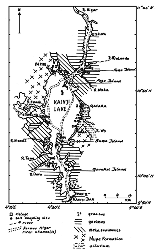
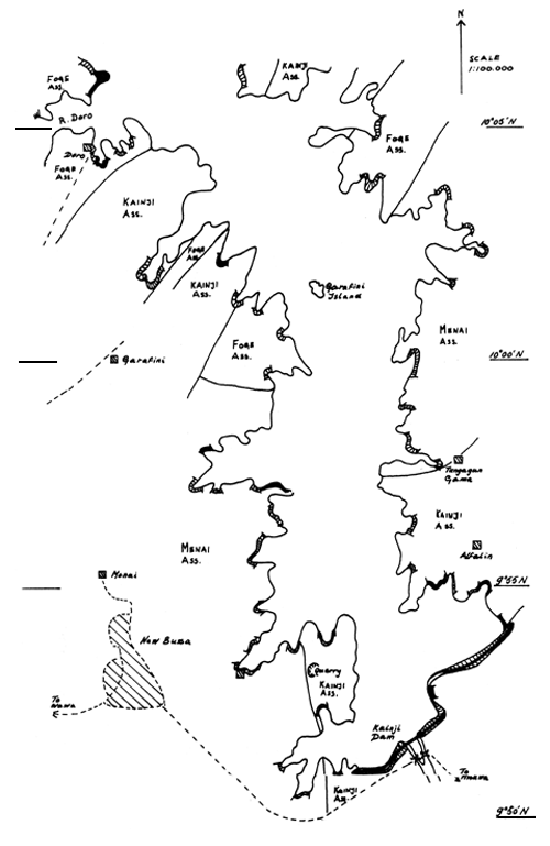
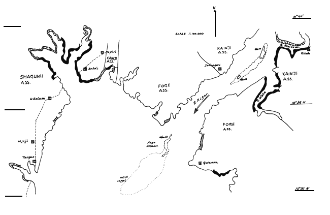
Fig.1 Location of Soil Sampling Sites and Geological setting of the Kanji Lake Basin
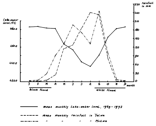
Fig. 2 Lake-water Level Variation and Rainfall Distribution
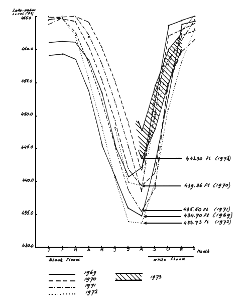
Fig. 3 Maximum and Minimum monthly Lake-Water Levels
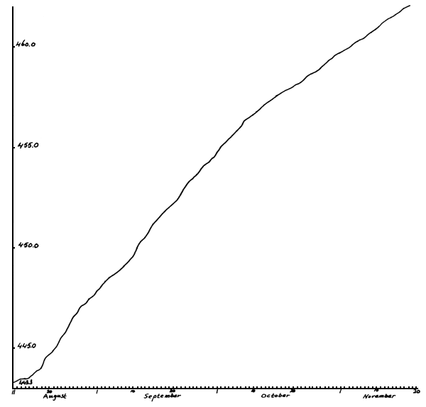
Fig. 4 Rise at the Lake-water from Lowest Level till 4620 pt.
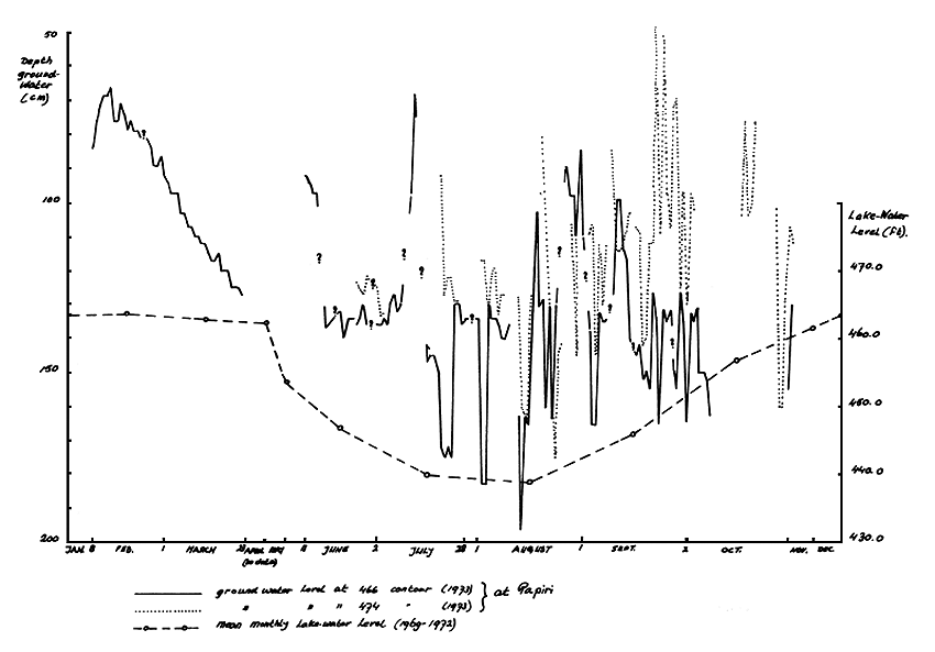
Fig. 5 Ground water variations and mean monthly Lake-Level.
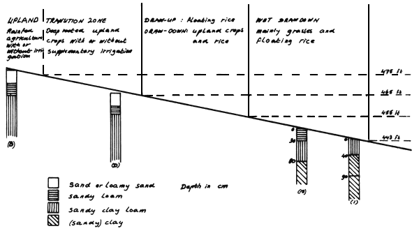
Fig. 6 Schematic Cross-section Draw down Area at Papiri
MAP 1
MAP 2

MAP 3
MAP 4
![]()
![]()