
ASSISTANCE TO FISHERIES RESEARCH INSTITUTE, MYMENSINGH
BGD/89/012
FIELD DOCUMENT NO. 5
Compiled and Edited by
Anwar Ali, Chief Scientific Officer, SPARSSO, M.A. Mazid, Director, FRI and V.R.P. Sinha, FAO/UNDP Senior Specialist
FISHERIES RESEARCH INSTITUTE, MYMENSINGH
GOVERNMENT OF THE PEOPLE'S REPUBLIC OF BANGLADESH
UNITED NATIONS DEVELOPMENT PROGRAMME
FOOD AND AGRICULTURE ORGANIZATION OF THE UNITED NATIONS
This electronic document has been scanned using optical character recognition (OCR) software and careful manual recorrection. Even if the quality of digitalisation is high, the FAO declines all responsibility for any discrepancies that may exist between the present document and its original printed version.
Objective of the training programme
Programme and Resource Persons
Name of the Participants and their Organizations
Inaugural Programme and Addresses
GIS for Fisheries - An introduction
Fisheries Development Plan of Bangladesh
Data Requirement for Inland Fisheries Planning and Development
Principles of Remote Sensing - Airborne and Satellite Remote Sensing
Satellite Data Processing and Image Analysis
Application of Remote Sensing and GIS in Shrimp Farming Areas of Bangladesh
Remote Sensing Applications for Marine Fisheries Resources in Bangladesh
Pond Concentration Studies in Bangladesh
Inventory of Inland Waters (Based on Study of SPARRSO, 1984)
Formulation of Periodic Atlas of Structured Information of Fisheries Resources
Short-Term Training Programme on GIS for Fisheries
14-18 November, 1993
1. Objectives:
Base-line reliable data on resource inventory for planning and management for sustainable exploitation of aquatic resources both in inland and marine sectors are urgently needed. This becomes all the more important in the dynamic situations, prevailing in Bangladesh with shrinking man land ratio, increasing rate of sedimentation and consequent low volume of water with loss/gain of nutrients with poor primary productivity management and utilization, change in the pattern of land and water use, taming of rivers, loss of flood plain fishery, increasing pollution load in the water, disruption of mangrove forest and increasing use of coastal area for shrimp farming, over exploitation of near shore area and under exploitation of EEZ.
It is important that Geographic Information System through development of digitised maps of the fisheries resources based on satellite imagery of sites and conventional studies for preparation of Atlas for fisheries be initiated to properly back up research and development planning and monitor the progress and their effect on environment. The computerized GIS utilizing the satellite imagery maps and ground data collected/generated by conventional surveys will provide a quick, reliable and structured informations for assessment and evaluation of impact of fisheries management and development programmes to help ensure sustainability of the aquatic ecosystem. Thus it is essential that fisheries researchers, development workers and the agricultural scientists should be familiarized with the system and also give their input in framing the required informations needed for GIS in fisheries.
2. Duration of Training
The duration of training would be for five days 14-18 November, 1993.
3. Venue:
The training programme would be conducted at the FRI Headquarters at Mymensingh and also at the Headquarters of Bangladesh Space Research and Remote Sensing Organisation (SPARRSO), Dhaka.
4. Candidate for training
The maximum number of candidate to be admitted for the training will be twenty consisting of Senior Scientists of FRI, BRRI, BARI, BFRI and Senior DOF Officials.
Short-Term Training Programme on GIS in Fisheries
|
(Programme at FRI, Mymensingh) |
||
|
14 November 1993
|
09.00-10.15 |
Inaugural Session |
|
10.15-10.30 |
Tea |
|
|
10.30-11.30 |
An overview of the Status of Fisheries and Aquaculture in the Country |
|
|
11.30-11.45 |
Discussion |
|
|
11.45-13.30 |
Principles of Remote Sensing (Two lectures) |
|
|
13.30-13.45 |
Discussion & Tea |
|
|
13.45-14.45 |
Fisheries Development Plan of the Country |
|
|
14.45-15.00 |
Discussion |
|
|
15 November 1993
|
09.00-10.00 |
Fisheries Development Plan of the Country |
|
10.00-10.30 |
Discussion & Tea |
|
|
10.30-12.30 |
Visit to FRI Laboratories & Fields |
|
|
12.30-12.45 |
Discussion & Tea |
|
|
14.30 |
Departure to Dhaka |
|
|
16 November 1993
|
09.00-10.00 |
Data Processing and Image Analysis |
|
10.00-10.10 |
Discussion & Tea |
|
|
10.10-11.10 |
Fundamentals of GIS |
|
|
(Programme at SPARRSO, Dhaka) |
||
|
|
11.10-11.20 |
Discussion |
|
11.20-12.20 |
Application of Remote Sensing to Environment with Special Reference to
Inland Fisheries and Aquaculture |
|
|
12.20-12.30 |
Discussion & Tea |
|
|
12.30-13.30 |
Demonstrations on Cartographic Activity |
|
|
13.30-14.30 |
Airborne and Satellite Remote Sensing |
|
|
17 November 1993
|
09.00-10.00 |
Case Studies |
|
10.00-10.10 |
Discussion & Tea |
|
|
10.10-11.10 |
Shrimp Farming |
|
|
11.10-11.20 |
Discussion |
|
|
11.20-12.20 |
Inventory of Water Bodies |
|
|
12.20-12.30 |
Discussion & Tea |
|
|
12.30-13.30 |
Marine Fisheries |
|
|
13.30-13.40 |
Discussion |
|
|
13.40-14.25 |
Data Requirement for Aquaculture Planning and Development |
|
|
14.25-14.40 |
Discussion |
|
|
18 November 1993
|
09.00-10.00 |
Strengthening of Fisheries Management Information System on Aquazone
basis |
|
10.00-10.15 |
Discussion |
|
|
10.15-11.15 |
Formulation of Periodic Atlas of Structured Information of Fisheries
Resources |
|
|
11.15-12.15 |
Demonstrations on ACEMS Activities and Vax Based GIS |
|
|
12.15-13.15 |
Demonstrations on PC based GIS |
|
|
13.30-14.15 |
Valedictory Function |
|
1. Mr. Md. Shahab Uddin, Senior Scientific Officer, Fisheries Research Institute, Mymensingh.
2. Mr. Md. Zahirul Hague, Senior Scientific Officer, Fisheries Research Institute, Mymensingh.
3. Mr. Yahia Mahmud, Scientific Officer, Fisheries Research Institute, Mymensingh.
4. Mr. Md. Shah Ali, Scientific Officer, Fisheries Research Institute, Mymensingh.
5. Mr. Masud Hossain Khan, Scientific Officer, Fisheries Research Institute, Mymensingh.
6. Mr. Syed Arif Mustafa Al-Arabi, Scientific Officer, Fisheries Research Institute, Mymensingh.
7. Mr. Khan Kamal Uddin Ahmed, Scientific Officer, Fisheries Research Institute, Mymensingh.
8. Mr. Syed Lutfor Rahman, Scientific Officer, Fisheries Research Institute, Mymensingh.
9. Ms. Nurun Nahar Begum, Scientific Officer, Fisheries Research Institute, Mymensingh.
10. Mr. Md. Wahed Ali Pramanik, Scientific Officer, Fisheries Research Institute, Mymensingh.
11. Mr. Md. Zulfikar Ali, Scientific Officer, Fisheries Research Institute, Mymensingh.
12. Mr. Md. Nurullah, Scientific Officer, Fisheries Research Institute, Mymensingh.
13. Mr. Rakhal Chandra Kangsa Banik, Senior Scientific Officer, Directorate of Fisheries, Dhaka.
14. Mr. Md. Fokhrul Alam, Scientific Officer, Directorate of Fisheries, Dhaka.
15. Mr. Manmatha Nath Sarker, Scientific Officer, Directorate of Fisheries, Dhaka.
16. Mr. Monzur Mourshed Bhuiyan, Senior Scientific Officer, Bangladesh Agricultural Research Institute, Joydebpur.
17. Mr. Malik M.A. Karim, Senior Scientific Officer, Bangladesh Agricultural Research Institute, Joydebpur.
18. Mr. A.K.M. Wazihullah, Senior Scientific Officer, Bangladesh Forest Research Institute, Chittagong.
19. Mr. Sukumar Das, Scientific Officer, Bangladesh Forest Research Institute, Chittagong.
Short-Term Training Programme on GIS for Fisheries
(Organised by FRI-Under FAO/UNDP Project BGD/89/012 in collaboration with SPARRSO)
14-18 November, 1993 Inaugural Session (Venue - FRI Auditorium, Mymensingh)
14 November, 1993
|
0900 |
: Registration |
|
0905 |
: Guests and Participants take seats |
|
0910 |
: Recitation from the Holy Quran |
|
0915 |
: Welcome address: Mr. Shah Md. Ershaduzzaman |
|
0920 |
: Introduction to the subject Dr. V.R.P. Sinha, FAO/UNDP Senior |
|
0930-1015
|
: Address by Chief Guest Dr. A.A.Z. Ahmad |
|
: Address by Chairman |
|
|
: Vote of Thanks |
Dr. V.R.P. Sinha
FAO/UNDP, Senior Specialist, Fisheries
Research Management & Development
The importance of base-line reliable data on resource inventory for planning and management for sustainable exploitation of aquatic resources both in inland and marine sectors needs not to be over emphasised. They become all the more important in the highly dynamic situations of Bangladesh.
Already terrestrial ecosystem is threatened with fast shrinking man land ratio. Population already stands above 110 million in the land of 55,598 square miles and expected to rise as high as 200 million by 2025. Every child born today would need 0.08 ha. of land for purposes like housing, roads, waste disposal, power supply and other uses and 0.4 ha. of land for producing the food he or she needs. The country as the eight most populous nation in the world with a growth rate of over 2% would need about 1 million ha. of additional land every year. Thus, the growing pressure of a fast expanding human and animal population on land would further lead to an alarming degree of destruction and diminution of the biological potential of land through erosion, alkanity, salinity, water logging and various other forms of soils abuses.
Similarly, the aquatic ecosystem is in peril with increasing rate of sedimentation and poor primary productivity management and utilization. It is estimated that 2.4 billion tons of silt pass annually from Bangladesh through the river systems compared to 1 to 2 billion tons in South and North American rivers respectively. It is estimated that amount of silt passing over to the Bay of Bengal has increased a hundred times in the last century.
Sunlight, which is abundant except during limited periods in the monsoon, offers fairly high intensity of solar energy over 500-600 cal/cm2/day. The solar energy flux has a net assimilation rate amounting to about 8 g biomass/m2/day or about 30 t dry matter/ha/yr which can produce fish at the rate of about 10-15 t/ha/yr without feed or fertilizers. Yet, it is seen that presently 5-10 t/h/yr of fish is produced with extraneous feed and fertilizers, reflecting very poor primary productivity management and utilization.
Change in the pattern of land and water use is common in the country with adoption of HYV in crop production. However, the extent of pond surface in this water-rich country amounts to about 0.26 million ha. representing only 2-3% of the arable land. But this is expected to increase day by day and would bring conflict with other water use.
Taming of rivers and consequent loss of flood plain fishery, add to the adverse effect on fisheries. Present active flood plains area remaining outside the FCD or FCDI projects are around 5.487 million ha. About 2.1 million ha of flooded land has already been brought under FCD. According to the Bangladesh Water Development Board's future plans another 2.4 million ha of flooded lands might be covered by the FCD project by the year 2005. Thus within another decade about 2.4 million ha. of fish producing area would be further reduced.
Pollution of water is yet another serious problem confronting fisheries sector. The present utilization of fertilizers in the country is over 2000 tons/yr which has increased by 124% over the last four years and about 400% since 1977. The industries in the country generally do not have much of waste treatment facilities, more so in the coastal area where over 1250 manufacturing industries are situated which is about 25% of the total industry in the country. These do not have any waste treatment facilities of approved design from the department of environments. In addition, municipal wastes also add to the pollution of the water bodies.
Disruption of mangrove forest and increasing use of coastal area for shrimp farming have resulted in the loss of 30,000 ha of mangrove. Marine Sector also suffered with over exploitation of near shore area and under exploitation of EEZ.
Thus, the whole situation becomes much more complex in the country. To add to this, many development projects have been initiated and in some cases completed with little access to scientific informations about fish and fisheries resources and also of socio-economic informations of those who are undertaking fisheries.
Under the above circumstances the country needs a most pragmatic ecologically sound, economically feasible and socially acceptable fisheries development plan.
For proper Fisheries Research Planning and Development and also to monitor the progress of development projects, quick and highly reliable and effective georeferenced data are essential. This could be possible through the Geographical Information System i.e. GIS, which is an advanced information technology. This can effectively capture, store, retrieve, update, analyse and finally display all forms of georeferenced data. It requires a synchronized arrangement of computer hardware, software, skilled personnel and geographically required spatial data with the help of satellite imagery, aerial photography, topo maps, ground truthing etc.
It is important that Geographic Information System is established through development of digitised maps of the fisheries resources based on satellite imagery of sites and conventional studies. This will provide a quick, reliable and structured informations for the required assessment and evaluation of impact of fisheries management and development programmes. Thus, it is in this context, it is thought appropriate that fisheries researchers and development workers should be familiarized with the Geographical Informations system and also give their input in framing the required informations needed for GIS for fisheries.
The course has been so designed in consultation with scientists from SPARRSO that proper exposure is given to the participants about the principle of remote sensing, different method of remote sensing, data processing and image analysis, fundamental of GIS along with relevant demonstrations. At the same time it is also ensured that SPARRSO scientists could also know the expected date requirements for Fisheries Research Planning and Development.
The training programme would focus on the different aspects of the Computerised Geographical Information System for fisheries which could assist the scientists to have useful information related to
- Baseline data on the fisheries sites, their catchment and drainage.- Ecological status of soil, water, aquatic biology, fauna and flora and land use pattern.
- Socio-economic status of fishermen, farmers community, in the bordering villages, thanas and districts; fish marketing infrastructure and trading practices.
- Monitoring the environmental changes in the different aquatic ecosystems, their catchment and drainage.
These informations would help in proper aquatic resource utilization, management and conservation of fisheries resources while preserving the environment and also in training manpower at primary, secondary and tertiary levels etc. for environment monitoring and management.
Thus, the science and art of remote sensing and GIS would help the participants in their endeavour to plan properly R & D in fisheries for the progressive utilization of aquatic resources most scientifically on sustainable basis.
Dr. M. Momtaz Uddin
DOF
1. INTRODUCTION
Role of Fisheries sector in providing better nutrition, additional employment generation and in foreign exchange earnings needs not to be over emphasised. It is estimated that 80% of the locally produced animal protein food comes from fisheries sources. Although fish intake in absolute term has declined from 33 gm in 1962 to 21 gm in 1988, the percentage contribution of fish as a source of animal protein is likely to further increase in the future. There are over 1.2 million commercial fishermen. Of 14-15 million rural households, about 9-10 million households, get involved in the seasonal or part-time fishing during the monsoon months. The share of fisheries in the total export earning is about 12%, which is third after jute and garments.
The prospect of producing animal protein from other sources are not very bright. With ever increasing population, the net area of land is decreasing and there is not much land which still can be made available for agriculture. It is estimated that, the present 1.3 acres of land per person will remain only by 2000 AD.
2. RESOURCES
Fisheries fall broadly into four categories:
(a) inland capture
(b) inland culture
(c) marine industrial
(d) marine artisanal
Inland fisheries in Bangladesh covers an area of 4.3 million ha of which 94% comprise openwater capture fisheries and 6% closed water culture fisheries. Besides the three main rivers viz., the Padma, the Meghna and the Jamuna/Brahmaputra, 700 rivers and streams totalling 22,155 km. An estimated 2.8 million ha of floodplains, 144,161 ha of beels and 68,800 hectares of Karnafuli reservoir offer considerable scope for augmenting fish production through culture based fishery management.
The culture fisheries of Bangladesh has an estimated 146,890 ha of ponds, 5488 ha of baors and 108,000 ha of shrimp farms. Application of improved culture techniques can increase the production to twice or three times in near future.
Bangladesh has a total fishing grounds of 24,000 sq. km. inside 10 m baseline. The shelf area of a the EEZ from 10 m to a depth of 200 m. provides an additional 42,440 sq. km. However, salinity, dissolved oxygen and water temperature tend to limit the distribution of marine fish to a narrow belt and the effective fishable area is reduced to 14,000 sq. km. The marine shrimp grounds are further restricted to about 700 sq. km.
Small-scale artisanal fisheries contribute about 95% of the total (237,000 tons) marine landings. In the artisanal sector there are 15,100 non-mechanized and 3500 mechanized boats. Nearly 190,000 fishermen are involved in fishing.
3. CHANGING SCENARIO
During the 3rd plan period (1984-85 to 1989-90) the target for production of fish from all sources was set at 10 lac tons during the terminal year (1989-90). However, the total production of fish from all sources fell short of the target by over 150,000 tons. During the plan period there had been a continuous decline of fish catches from inland openwater sources which was estimated at 40,000 tons. The important factors for the decline of catch are (a) large-scale water abstraction for irrigation, (b) construction of embankments for flood control (c) siltation and soil erosion due to deforestation in the catchment, (d) water pollution from industrial, agricultural and municipal wastes, (e) over-exploitation and destructive fishing practices etc. Apart from steady decline in the total catch, there is an alarming decline in the catches of the riverine fish. The biologically and economically desirable species have given way to lower valued species. While inland capture fisheries contributed 471,591 tons or 62.6% of the total catch in 1983-84, the same declined to 50.4% in 1989. This, along with rapidly growing population, has led to the decline in per capita availability of fish. It is estimated that by the turn of the century, fish production must increase to 1.2 million tons, if the growing population of the country has to consume fish even at the present lower (20 gm/day) level of per capita availability.
4. GOVERNMENT POLICY
The major national objectives for fisheries development as outlined in the Fourth Five Year Plan are:
a) to increase fish production for domestic consumption.b) to improve the socio-economic conditions of fisherman and others engaged in fisheries
c) to create additional employment opportunities in fish culture and ancillary industries to improve socio-economic condition and ensure better standard of living of the fishing community.
d) to develop fish production and fisheries management technology.
e) to train required manpower at all levels for facilitating the transfer of technology.
f) to increase foreign exchange earnings through export of fish and fish products.
g) to improve general environment and conserve ecosystem.
h) to conserve fishery resources for sustainable development.
Except for a small quality of fish produced in Government farms and limited quantity of fish harvested by BFDC trawlers, all production activities are undertaken by the private sector. Besides, private sector is almost entirely involved in marketing, processing, export and other related activities in the fisheries sector. The Government policy is, therefore, aimed at providing technical advice and support services to the private sector.
In order to foster recovery of the dwindling stocks and to improve fish production, Government have adopted the following strategies:
(1) Large-scale stocking of inland openwater and inundated floodplains with rigid enforcement of fish and fish habitat conservation practices.(2) Identification of new fishing grounds in marine waters through surveys and explore the possibility of exploiting un-exploited or under-exploited resources.
(3) Intensification of aquaculture practices to obtain increased production per unit area.
(4) Policy support for improving quality of fish and fish products for local consumption as well as for export.
(5) Develop adequate infrastructure to support planned expansion of shrimp culture in the private sector.
(6) Formulation and implementation of a well-defined land/water use policy to avoid wasteful resources conflicts along with effective measures against dumping of industrial and other wastes into openwater systems.
(7) Development of skilled manpower, appropriate research & technologies expended institutional/organisational capabilities to plan and implement development activities.
(8) Biological management of water bodies with a view to obtain yield at maximum sustainable yield (NESY) level.
5. DEVELOPMENT PLANS
Bangladesh became an independent state in December 1971. The First Five Year Development Plan (1973-78), was followed by a two Year Plan (TYP) (1979-80). Second and Third Five Year Plans were implemented during 1980-85 and 1985-90. The country is currently implementing its Fourth 5-Year Plan. The broad objectives and targets for all the development plans have been more or less the same i.e. increasing fish production for domestic consumption and export, generating employment opportunities, improving socio-economic conditions of fisherfolk, conserving the resources etc. Fish production targets, achievements and utilization of fund during different plans are furnished below:
|
Plans |
Target '000 tons |
Production achieved '000 tons |
|
FFYP (1973-78) |
102.000 |
643 |
|
TYP (1978-80) |
80.000 |
646 |
|
SFYP (1980-85) |
100.000 |
774 |
|
TFYP (1985-90) |
100.000 |
847 |
|
Plans |
Allocation (N) |
Actual utilization |
% utilization |
|
FFYP (1973-78) |
485 |
190 |
39 |
|
TYP (1978-79) |
440 |
386 |
88 |
|
SFYP (1980-85) |
1743 |
1583 |
90 |
|
TFYP (1985-90) |
3500 |
1400 |
40 |
In addition to the various stresses on the inland, coastal and marine waters, there are a number of institutional and social constraints impeding fisheries development. Major factors are inadequate investment, lack of appropriate technologies, lack of infra-structural facilities in potential but remote areas of production, inadequate extension service, institutional weakness in planning, implementation and monitoring of fisheries sector and inadequate trained and motivated manpower. On top of everything, there is no national policy on development of fisheries in the country. Of late the MOFL has prepared a draft policy paper which is expected to be finalized soon.
The fish production target during the terminal year of the Fourth Five Year Plan (1990-95) has been set at 1.2 million tons. At the same time, target for export earnings during the FFYP is set at 64,000 tons and Taka 9715 million. In order to implement the fisheries development programmes Taka 7,490 million has been allocated for public sector during the FFYP. This includes Taka 2,210 million for implementation of ongoing projects spilled over from the TFYP. In addition to the public sector allocation of Taka 7,490 an amount of Taka 6,000 million is expected to be invested by the private sector for implementation of the fisheries development programmes.
6. RECENT DEVELOPMENTS
a) There had been a continuous decline of fish catches from inland openwater sources since 1983-84.
b) There had been a substantial increase in production from closed water culture fisheries.
c) The Government recognized the need for rehabilitating the openwater fishery resources and initiated large-scale stocking of carp fingerlings in floodplains since 1989.
d) The IDA financed oxbow lake project demonstrated that fish yield in ox-bow lakes can be increased from 100 kg to 950 kg/ha/year through appropriate culture-based management.
e) The Government has successfully demonstrated the operation of large-scale carp hatcheries and nurseries in the early 1980s and private sector took up these operations quickly and provided a big boost to aquaculture.
f) The rapid expansion of shrimp culture during the 1980s had been one of the most-remarkable development in the country's fisheries sector. From an estimated 51,834 ha of shrimp farms in 1983-84 the area had expanded to 108,000 ha in 1989-90 with a production of 18,235 tons from 7,578 tons in 1983-84.
g) Based on the success of the first phase Baor Development project, a second phase project for development of 30 baors in the greater districts of Jessore, Kustia and Faridpur has been taken up. In this project the fishermen with the assistance of an NGO (BARC) will develop, operate and manage the baors to receive 100% benefit from the production. The DOF shall, however, provide infrastructure like roads, electricity, fish landing and storage facilities.
h) The New Fisheries Management Policy as initiated in 1987 to improve productivity, allows access to a fishery directly to the fishermen.
i) There had been an outbreak of FUS disease in the country in 1988 which caused considerable decline in fish production.
j) The NGO's initiated programmes for fisheries development by involving and organizing fishermen groups, fish farmers and unemployed youths.
k) The Fisheries Research Institute was established and became operational in 1986. It has developed relevant technologies in freshwater aquaculture.
l) The development partners gave adequate priority to fisheries sector and contributed to increased spending which was 70% in 1988-89 as against 40% in 1982-83.
7. DEVELOPMENT STRATEGIES
The following strategies have been identified for achieving the objectives of fisheries development.
a) Development of appropriate technologies for increasing production in open and closed water bodies.
b) Development of skilled manpower.
c) Strengthening of institutional/organizational capabilities to plan and implement development activities.
d) Biological management of Jalmohals by providing fishing right to genuine fishermen and gradual replacement of existing leasing system.
e) Application of culture-based fisheries enhancement programme for replenishment of openwater fisheries.
f) Rigourous enforcement of fish and fish habitat conservation practices.
g) Development of effective mechanism for transfer of technology.
h) Gradual intensification of aquaculture practices to obtain increased yield per unit area.
8. CONSTRAINTS TO DEVELOPMENT
A number of diverse and complex problems confront fisheries development in Bangladesh. Some of these constraints are listed below:
a) Absence of statistics on catch and effort over time and space by gear types and lack of understanding of parameters of hydrology, fish stocks and dynamics of their populations make estimation of exploitation structure and MSY difficult.b) Lack of suitable and tested model for estimation of stock and MSY for multispecies, multigear tropical fisheries.
c) Dearth of information on size composition, annual recruitment and migration of larvae and juveniles to and from the coastal waters.
d) Weak data base on inland fishery resources.
e) Anthropogenic stresses such as over abstraction of water for irrigation, construction of embankments for flood control, siltation of river beds, pollution from urban, industrial and agricultural runoff, over-exploitation and destructive fishing practices leading to mortality of fish and fish food organisms, preventing natural recruitment, destruction of breeding grounds and impediments in fish migration are the major environmental constraints.
f) Salinity incursions into the estuaries is increasing and moving upstream for fall in headwater flow.
g) Regulations have played a subordinate role in protecting the fisheries owing to lack of enforcement machinery.
h) The complexity of factors involved in the regulation of fisheries stems from the common property nature of the resources, difficulties in enforcing a limited entry concept, divergent leasing policies and multiplicity of agencies that control the water resources.
i) Over-population of the coastal zone, low social, educational and economic status of fishermen, lack of alternative incomes and lower environmental awareness cause increased pressure on the coastal resources.
j) Industrial effluents cause direct fish kills, destruction of habitats for benthic and planktonic communities and toxicity to fish organisms. Municipal wastes cause deoxygenation, high BOD load, rapid eutrophication and bio-accumulation of pesticides and heavy metals.
l) Weak extension capabilities of fisheries extension agencies including DOF cause problem in transfer of technology.
k) Institutional credit for fishermen, fish farmers and other aquaculture entrepreneurs are not available because of high interest rate and security and collateral problems.
9. DEVELOPMENT PROGRAMS
The Department of Fisheries currently implements 7 investment and 5 technical assistance projects. Total investment cost for the 12 ongoing projects is taka 636 crore with a provision of taka 87 crore in the annual development programme. Current development spending is highest in the history of the Department of Fisheries.
The projects are designed to develop and implement programmes for
i) enhancement of productivity of inland openwater resources through massive stocking of carp fingerling.ii) development of fresh and brackishwater aquaculture through demonstration and transfer of technology.
iii) development of infrastructure like hatcheries, training centers, demonstration farms to support private sector entrepreneurs and
iv) development and strengthening of DOF infrastructure.
Bangladesh Water Development Board implements Shrimp Culture infrastructure development component of the IDA assisted Shrimp Culture and Third Fisheries Project. To deliver the needed credit for aquaculture and fisheries development in the country, the Bangladesh Bank and Several Commercial Banks implement credit component of the IDA assisted Shrimp Culture Project and ADB assisted 2nd Aquaculture Development Project. Total provision for aquaculture and fisheries credit in these projects is taka 129 crore. In addition, the Fisheries Research Institute implements research component of the Third Fisheries Project.
Several other projects are in the pipeline. The following three projects are under preparation for implementation from the next financial year with Danida assistance.
i) Second phase Aquaculture Extension Project, Hymensingh-Dhaka.
ii) Shrimp-carp polyculture development in greater Noakhali.
iii) Fisheries development in Patuakhali and Borguna.
10. CONCLUSION
As already stated a number of diverse and complex problems confront fisheries development in the country. Research needs in capture and culture fisheries of both freshwater and marine sector have been identified. Fisheries Research Stations in the Country should address these issues and develop, test and refine appropriate technologies by undertaking adaptive research both in laboratories as well as in the field. Technologies to be developed should be economically feasible, commercially viable and socially acceptable. Once such technologies are developed and refined the extension agents should be responsible for the transfer of technology in the form of simple messages. A co-ordinated research approach with active participation of farmers, researchers and extension agents is essential.
Dr. A.K.M. Aminul Haque
Ex-Vice Chancellor of BAU
1. Fish is an aquatic vertebrate. Similarly, all other organisms of commercial importance (and therefore, of fisheries importance) like sponges, corals, shrimps, oysters, cephalopods, holothurians, sea weeds, etc., are all aquatic in their habitat.
Naturally, they get all their requirements of life - oxygen, food, shelter, etc. - from water.
Similarly, the parasites, the pathogens, and many of the predators, etc., of fishes are also aquatic.
2. Qualitative and quantitative changes in the. Aquatic environment are bound to affect this habitat - which in turn affect life-processes of fishes and all other fisheries organisms as alluded to above.
It follows, therefore, that by manipulating the factors in the aquatic environment it is possible to bring about qualitative and quantitative changes/improvements in the fisheries resources.
3. For development of fisheries of any geographical region, it is essential to have, as much as is possible under the prevailing situation, accurate information on all the physical, chemical and biological factors involved - both in space and in time - so as to be able to decide on the changes/manipulations needed to bring about improvements in the conditions.
4. Remote-sensing and other appropriate technologies including conventional methods in collaboration with Geographical Information System (GIS) may collect information, at predetermined regular intervals, on all physical, chemical, and biological parameters relevant to planning and development of inland fisheries of the geographical area concerned, and process the data to a usable form. It is hardly possible to make a list of all such parameters relevant to a complex subject like fisheries. However, an attempt is made here in the present paper to list some of the factors on which information is desirable for development of inland fisheries. The technologies to be applied may choose their areas of investigation from this list to prepare a data-bank for use by researchers.
5. Ponds
5.1. Physical factors
- Number of ponds - perennial, seasonal
- Size (area) of individual ponds - classification according to size
- Dimensions (NS X EW) of individual ponds
- configuration of bank (shore-line)
- gradient (of slope)
- soil type
- nature and extent of erosion, if any
- vegetation on banks - north, east, south, west
- depth of water at different times of the year - contour map
- outlets/inlets, if any
- Turbidity
- Temperature- at surface at
- 2m depth
- at bottom- Available transport facilities
- Railway tracks, highways in the vicinity
5.2 Chemical factors - seasonal variations
- Dissolved oxygen
- Dissolved carbondioxide
- Other gases
- Dissolved/suspended organic matters - kinds, quantity
- Dissolved/suspended inorganic matters - kinds, quantity
- pH
5.3 Biological factors - seasonal variations
- Vegetation types in the pond water
- emergent
- submergent
- floating
- Phytoplankton
- types
- number of different types per unit volume of water
- Zooplankton
- types
- number of different types per unit volume of water
- diurnal migration pattern
- Benthos
- types
- number of different types per unit volume of bottom soil
- Species composition of standing fish population - relative abundance of various species
- cultured fishes
- weed fishes - predatory fishes
- Crustacean population
- species composition
- Molluscan population
- species composition
5.4 Other factors
- Ownership pattern
- Management types
- private management- single owner management
- multiple owner management- government management
- NGO management
- combination
- Management problems, if any
- Fish culture practices, if any
- pre-stocking treatments, if any
- stocking pattern
- species combination
- sources of fry/fingerlings
- Uses other than fish culture
- irrigation
- washing
- bathing
- cattle bathing
- duck raising
6. Baors and beels (also swamps)
6.1 Physical factors
- Age
- History of development/evolution
- Size (area of water) of individual waterbody
- Map showing location and outline
- Soil types
- Nature and extent of erosion, if any
- Land vegetation on banks/surrounds
- Depth of water at different times of the year - contour map
- Outlets/inlets, if any
- Seasonal variation in
- turbidity
- temperature- air
- water- at surface
- at 2m depth
- at bottom- diurnal variation
- Rainfall/precipitation
6.2 Chemical factors - diurnal and seasonal changes
- Dissolved oxygen
- Dissolved carbondioxide
- Other gases
- Dissolved/suspended organic matters - qualitative assessment, quantitative assessment
- Dissolved/suspended inorganic matters - qualitative assessment, quantitative assessment
- pH
6.3 Biological factors
- Aquatic vegetation types - relative abundance
- emergent
- submergent
- floating
- Phytoplankton
- types
- abundance
- distribution
- Zooplankton
- type
- abundance
- distribution
- diurnal migration pattern
- Benthos
- qualitative information
- quantitative information
- Species composition of standing fish population
- relative abundance of each species
- distribution in space
- Crustacean population
- species composition
- abundance
- Molluscan population
- species composition
- Avian population, seasonal pattern
- residents
- migrants
- feeding habits
6.4 Other factors
- Ownership pattern
- Management types
- private management- single management
- joint management- government management
- NGO management
- participatory management - New Fisheries Management Policy
- combination
- Management problems, if any
7. Reservoirs
Reservoirs are special type of lotic environment - transitional from riverine to mainly lacustrine - and hence deserve special consideration.
7.1 General considerations
- History of development
- history of the river concerned
- considerations leading to the construction of dam- benefits anticipated- soil types
- cross section at different points of the basin
- vegetation types before inundation on commissioning of project
- species composition
- density/distribution pattern of various species
- fate of the standing vegetation
- fish species of the erstwhile river/tributaries
- fisheries in the erstwhile river/tributaries
- concentration of human settlements in the valleys
7.2 Physical factors of the reservoir
- Geographical area covered by the reservoir
- at highest level of water
- at lowest level during dry season
- Total water area
- at highest level of water
- at lowest level during dry season
- Total catchment area
- Age since construction of dam
- Rainfall/precipitation, seasonal changes
- Seasonal changes in the discharge rate
- through spill-ways
- through turbines, if any
- total
- Nature and extent of erosion, if any
- wave action
- human interference
- other causes
- Shore vegetation types along the valleys
- Topography of the valleys
- Topography of the basin - contour map
- Seasonal variation in
- turbidity
- temperature- air
- water
- Seasonal Variation in velocity of current
- at surface
- at 2m depth
- at bottom
- pattern of circulation
- upwelling, if any
7.3 Chemical factors
- Dissolved oxygen
- Dissolved carbondioxide
- Other gases
- Dissolved/suspended organic matter - qualitative assessment, quantitative assessment
- Dissolved/suspended inorganic matter - qualitative assessment, quantitative assessment
- pH
7.4 Biological factors
- Aquatic Vegetation types - relative abundance
- emergent
- submergent
- floating
- Phytoplankton
- types
- abundance
- distribution
- Zooplankton
- types
- abundance
- distribution
- diurnal migration pattern
- Benthos
- Distribution patten of various species at different depths- qualitative information
- quantitative information
- seasonal variation
- Species composition of standing fish population
- relative abundance of different species
- distribution pattern of various species
- Aquatic/semi-aquatic mammalian population
- Crustacean population
- Species composition
- relative abundance
- distribution
- Molluscan population
- Species composition
- relative abundance
- distribution pattern
- Avian population, seasonal pattern
- residents
- migrants
- feeding habits
- Stocking data, if applicable
- species stocked
- number stocked - by species, by size-groups
- data(s) of stocking
- survival rate
- Harvesting data
- gears used
- species harvested-number in each size-group
- Mortality due to natural causes
- diseases
- parasites
- predators
7.5 Other factors
- Management pattern
- Management problems, if any
8. Rivers
8.1 Physical factors
- Origin
- History of changes, if any, in the course
- Age
- Division of basin, o morphological considerations, into segments
- Map showing location and course
- Whole river system including tributaries and distributors
- individual segments
- Soil type of different basins
- Cross section of different basins
- Nature and extent of erosion of banks, if any
- Depth of water at different times of the year
- Tributaries
- Distributors
- Seasonal variation in
- turbidity
- air temperature
- water temperature - at surface, at 2m depth, at bottom
- velocity of current - at surface, at 2m depth, at bottom
- Rainfall/precipitation
- Extent and condition of floodplains
8.2 Chemical factors
- Dissolved oxygen
- Dissolved carbondioxide
- Other gases
- Dissolved/suspended organic matter 0 qualitative assessment, quantitative assessment
- Dissolved/suspended inorganic matter - qualitative assessment, quantitative assessment
- PH
8.3 Biological factors
- Aquatic vegetation types
- emergent
- submergent
- floating
- Phytoplankton
- types
- relative abundance
- distribution
- Zooplankton
- types
- relative abundance
- distribution
- diurnal migration pattern
- Benthos
- qualitative information
- quantitative information
- Species composition of standing fish population
- relative abundance of each species
- distribution- in space
- in time
- migration pattern of any fish species
- Crustacean population
- species composition
- relative abundance of different species
- distribution- in space
- in time
- migration pattern, if any
- Molluscan population
- species composition
- relative abundance of different species
- distribution- in space
- in time
- Avian population - seasonal pattern
- residents
- migrants
- feeding habits
- Mammalian population
- dolphins
- otters
- any other(s)
- Stocking data, if applicable
- species stocked
- date(s) of stocking
- number - by species, by size-groups
- survival rate
- Harvest data
- gears used
- number harvested - by species, by size-groups; by weight
- Mortality due to natural causes
- diseases
- parasites
- predators
8.4 Other factors
- Management pattern
- lease-based management
- new fisheries management policy
- participatory management
- Management problems, if any
9. Factors relevant to fisheries practices
9.1 Inland capture fisheries
- Life history of fishes
- commercial fishes
- weed fishes
- aquarium fishes
- others
- Life-history of non-piscine fisheries organisms
- Pollution status - pollutants
- Sediment transport
- Fish seed sources - finfishes, shellfishes
- natural sources
- hatcheries
- Hilsa fishery
- factors for migration
- responses to various stimuli - at different stages of life
- rheotactic responses
- chemotactic responses
- effect of barrages
- effect of other human interferences
- nets across river-mouths
- pollutants
- destruction of juveniles
- Pangasius fishery
- Masheer (Mahashole) fishery
- Impact of openwater stocking
- Impact of New Fisheries Management Policy
- Reservoir fishery reaction to transition from riverine to mainly lacustrine ecology
- Fish transport - fry/fingerling transport
- Fish marketing
- Estuarine fishery - management under Forestry Department versus management under Fishery Department
- Conservation and management - impact of participatory management practices
9.2 Inland culture fisheries
- Life - history of culturable fish species - breeding habits, - Induced breeding
- Food and feeding habits
- Soil-water interaction - fertilization
- Effect of various fertilizers
- Hatchery operations and management
- common problems
- Shrimp hatcheries - Penaeus, Macrobrachium
- Fish seed industry
- Fish-cum-duck farming
- Predatory and weed fishes - control measures
- Aquarium fishes - potential for export market
- Aquatic insects - control measures
- Fish food organisms - commercial production
- Feed formulation - for various stages of life-history of various culturable fish-species, supplemental feeding
- Stocking rates - intensive and semi-intensive culture practices
- Composite culture
- Aquatic weed control - mechanical, chemical, biological
- Transport of brood fishes
- Transport of fish seed
- Causes of mortality in transport operations Use and effect of various drugs
- fish toxicants - anaesthetics
- antiseptics
- antibiotics
- Culture of exotic fishes
- Culture of carnivorous fishes
- snakeheads
- climbing perch
- air breathers
- Fish pathology, fish parasitology - epizootic ulcerative syndrome
- Brackishwater ponds
- Water quality - salinity
- Soil quality
- Collection of seed from natural sources - effect on fish population in general
- Coastal aquaculture
- Remote-sensing and fisheries development potentials
10. An attempt has been made to indicate briefly areas where information is needed for meaningful fishery operations as well as for planning and development of inland fisheries of any geographical area. Use of satellite imageries, aerial photographs and other appropriate technologies along with conventional methods, in combination with Geographical Information System (GIS) have opened up a new vista of possibilities and can already provide dependable indications for identifying development potential of any sub-sector of fisheries and for selection of suitable sites for fisheries enterprises. A data-bank incorporating all needed information relevant to fisheries and aquaculture will be a handy - and essential - facility for planning and development of inland fisheries.
Dr. Anwar Ali
Space Research and Remote Sensing Organization (SPARRSO)
Agargaon, Sher-e-Bangla Nagar
Dhaka, Bangladesh
Introduction
Remote sensing is the technique of gathering information about an object without coming into physical contact with the object.
The first and the immediate examples of remote sensing are the human remote sensing like smelling, hearing and seeing. The most important of them all is the visual observation in which case the eye and the brain are the key components. Visible light reflected or emitted by an object is detected by the eye (a sensor) and transmitted to brain (a high speed real time data processor or computer) to give a visual image of the object.
But human remote sensing has limitations. Although it can see to infinity, it cannot distinguish between things beyond a certain distance. It also cannot see in other ranges of the electromagnetic spectrum like infrared and microwave. It is limited to visible ranges of the spectrum only. However artificial sensors can see through much larger distances and a few other ranges of the spectrum. Technically the term remote sensing, which was coined in the early 1960s by geographers in the office of Naval Research of the USA, is used to see an object from a distance with artificial 'eyes' or sensors. In the present day context, the term is most commonly used to observe the earth from platforms in space (aircraft, satellites, etc.).
However, there are a number of ways of gathering information through remote sensing even without the use of satellites. In facts, these practices have been in use even long before the invention of satellites. A few examples are:
Astronomy: Almost the whole subject of astronomy is based on remote sensing.Cameras: They are in use from long before the satellite remote sensing came into existence.
Marine acoustics: Ultrasonic waves which do not travel far in the atmosphere but travel a large distance in water are useful for bathymetric work, detection of submerged installations, fish, etc. and in underwater communication.
Photography from balloons: Earliest known photograph from a balloon was taken as early as in 1859 in Paris.
Aerial photographs: Wide development and applications were made during World War I and extensive development was done during World War II. Remote sensing in its earliest stages was dealing mainly with aerial photography and photo interpretation.
The advent of satellite in 1957 gave birth to the beginning of satellite remote sensing.
In satellite remote sensing, sensors on board satellites collect data about the earth's surface and the atmosphere below it and transmit the data/information to satellite ground station for subsequent processing, analysis, interpretation and applications. Remote sensing is comparatively a new field. It encompasses a wide spectrum of subjects like natural sciences, environmental sciences, engineering and technology, social sciences, space science, and planning and management. It is a technique, a science, a technology and an art. It has multidisciplinary involvement. Being a new field, remote sensing has created a great impact throughout the world. The subject is fast developing and is having an ever increasing importance.
The Basic Remote Sensing Principles
The observation of the earth's surface and the atmosphere below the aircraft or satellite is made by some sensors. These sensors take pictures of the objects below and/or collects information about them and relay the data to the ground station. The taking of pictures is done through the electromagnetic radiation. The whole spectrum of EMR is not used. Some bands of wavelengths are used.
As is well known is physics, energy is transmitted from one place to another in three different ways: conduction, convection and radiation. Every object not at absolute zero temperature radiates energy. This radiation propagates in a wave like fashion. The important characteristics of a wave is its wave length (or frequency), amplitude, direction of propagation and the polarization. The wave length may vary from zero to infinity. On the basis of the wave length (or frequency), radiation is divided into different spectra or bands. Some of these bands are:
Gamma rays X-rays, ultra-violet, visible, infrared, microwave, radio and audio (sound) waves.
Sensors are made responsive to certain wave bands in the visible, infrared and microwave ranges. These bands are mostly used in satellite remote sensing.
The visible radiation extends from a wavelength of about 0.4 micrometre (blue light) to about 0.75 micrometre (red light). Sun is the main source of visible radiation. This radiation is reflected by an object and the reflected radiation travels back to space and is captured by the sensors.
Infrared radiation is not detectable by human eye but by specially designed sensors. Infrared radiation is divided into two regions-near infrared (NIR) and thermal infrared (TIR). Near infrared follows the red light of the visible spectrum of the higher wavelength side. It ranges from approximately 0.75 micrometre to about 1.5 micrometres. Thermal infrared range varies from 3 or 4 micrometres to 12 or 13 micrometres. The NIR is important for vegetation mapping because vegetation reflects strongly in this wavelength. Water is almost a perfect absorber of NIR.
There are three principal reasons why remote sensing is restricted to visible, infrared and microwave regions: (i) amount of radiation, (ii) less atmospheric attenuation and (iii) easy recovery. A substantial amount of radiation should be received by the sensor, otherwise it may not be possible to have a noticeable characteristic of the radiation. Secondly, the emitted/reflected radiation should not be appreciably attenuated by the atmosphere in its journey from the object to the sensor. The attenuation by the atmosphere is a function of wavelength. Some waves are less attenuated and some are strongly attenuated. If any radiation of a particular wavelength is not attenuated, then this wavelength is called a window wavelength (atmospheric window). The third condition is that the data generated by the sensors should be recoverable. The visible, infrared and microwave regions have favourable response to the above-mentioned three conditions.
EMR as means of RS
The satellite sensors receive radiation emitted from or reflected by an object. The measurement of emitted radiation provides the estimation of the temperature of the emitting body. The reflected radiation provides an identification of the nature of the reflecting object, the reflection being a characteristic of the body. It is described as a spectral signature of the body, by which nature of the body can be identified. The reflectance characteristics of a body or its spectral signature is a function of wavelength. By studying the spectral signatures, the nature of a body can be identified. And this is the philosophy behind using EMR in remote sensing.
Passive and active remote sensing
Sensors are of two different types: passive and active. Passive sensors respond to the radiation that is incident upon them. Reflected sunlight and emitted radiation from the earth are among these waves. Active sensors generate their own radiation like microwave and send them downward to the earth. This radiation is reflected back to the sensors. Visible, infrared and microwave radiation are used by passive systems and microwaves by active systems. Active systems operating in the visible and IR region are not flown on satellites, but on aircrafts.
Imaging and non-imaging systems
Sensors can be divided into two categories: imaging and non-imaging. The reflected or emitted radiation can produce images through the sensors of the part of the surface of the earth or the clouds. If the sky is overcast with clouds and images are taken in the visible and infrared wave bands, then the images are of the clouds. Microwaves can see through clouds and take pictures of the earth's surface. The non-imaging systems in which case no images are formed give information about satellite height, integrated value of certain parameters like surface roughness, wind vector (speed and direction), etc.
Satellite system and sensors
In collecting information about the earth from space, two types of space platforms are mainly used-aircrafts and satellites, although balloons, rockets, etc. are also occasionally used for specific purposes. Aircrafts and satellites have particular advantages and disadvantages which are discussed later. It should be sufficient for the time being to note that aircrafts fly below the satellite heights.
We shall concentrate here on satellites and sensors on board the satellites. The Moon is the earth's only natural satellite. But there are innumerable artificial satellites that are presently moving around the globe. Each of these satellites has been designed for special purposes. Depending on their uses, the satellites are named differently, e.g.
Weather satellites
Resource satellites
Communication satellites
Defence satellites
The first two are the remote sensing satellites and are open to civilian applications.
Manned & unmanned satellites
Manned satellites are those in which men were on board the satellites. They are usually of short duration and amount of data received from them are very little compared to the demand. Manned satellite programmes were more of prestige concern. They are not worth satellite remote sensing. Unmanned satellites are the ones in which there is no man inside the satellite and they are the ones about which all the discussions relating of satellite remote sensing will be made here.
Period of revolution
Satellites move around the earth along certain orbit above the earth's surface. For a circular orbit, the period of revolution, T, depends only on the radius r provided the satellite altitude is high enough to be almost free from atmospheric drag.
Satellite orbits and altitudes
Satellites, for a better life time, should be put into a minimum operational heights. Otherwise, because of frictional drag of the atmosphere and gravitational pull of the earth on the satellite, the satellite will re-enter the earth's sphere of influence and burn out or fall onto the earth. In Table 1 is given the average life of a satellite before re-entry corresponding to the satellite altitudes.
It will be seen that there is a lower limit below which the satellite cannot be operated. Usual designed life time of a satellite is from 1-5 years, which requires an operational altitude of about 450 km.
Polar orbiting and geostationary satellites
Satellite orbits are generally of two types: near-polar and geostationary. The near polar orbiting satellites move in the north-south direction with some inclination with the earth's equatorial plane. Their usual heights above the earth's surface is about 800-900 km. At this height, the period of revolution is about 90-100 minutes. If the radius of revolution is increased by increasing the altitude, the period will naturally increase. The moon, which has a period of revolution of about 28 days, has its radius of revolution of about 384,400 km. Obviously somewhere in between these two radii (800-900 km and 384,400 km) there is a radius for which the period will be exactly 24 hrs or a day. This radius is approximately 42,250 km with the corresponding altitude of about 36,000 km. If a satellite is launched to move at such a height over the equator in the same direction of the rotation of the earth, then the satellite's position will be fixed relative to a position on the earth's surface. That is, the satellite will be geostationary with respect to the earth. All the communication satellites are geostationary. The near-polar orbiting satellites are made sun-synchronous so that satellites view the same point on the earth's surface at the same local time.
Orbit/swath/pixel
The polar orbiting satellite moves in a north-south plane making on angle with the earth's equatorial plan. For half of an orbit, the satellite is in the day period and for another half it is in the night period. The north bound movement is called ascending mode and the south bound trip is called the descending mode. The period of revolution determines the number of orbits required to make one complete coverage of the earth. It is to be mentioned here that a polar orbiting satellite does not move towards east or west, it is made to move in its orbital plane which is fixed in position. The earth beneath the satellite (moving from west to east) exposes its surface to the satellite.
While the satellite moves (north-south, say) the instruments on board scan the earth below across the track (either from left to right or from right to left). The scanning is done by rotating the instrument across the track along a line called scan line. Thus the instrument can see a certain distance across the track. The maximum distance the instrument can see is called swath width. Swath width is measured by the total angular swing of the instrument. It can also be measured by the distance the instrument covers across the scan line. Swath may also be called the general field of view of the instrument.
Instruments on board the satellite record pictures of the earth's surface by small surface elemental areas called picture element (pixel). The pixel gives the average radiation received from the pixel area. The pixel centre is located on the scan line, covering certain distance along and across it.
Weather Satellites
Polar-orbiting weather satellites
The first artificial satellite Sputnik I was launched on October 4, 1957. About 2.5 years later the United States launched the first operational meteorological satellite TIROS-1 (Television and Infrared Observation Satellite) on April 1, 1960, for weather monitoring. Prior to the space age, meteorologists were collecting upper air data using balloons and rockets, although balloons are still in use. TIROS-1 ushered in a new era in meteorological observations from space. Ten TIROS satellites were launched in the series from 1960-65. This first generation of meteorological satellites was followed by the second generation of ESSA (Environmental Science Services Administration) series from 1966-69. The third generation, TIROS-M series started with the launching of ITOS-1 (ITOS-Improved TIROS Operational system) in January 1970 after which the satellites were termed NOAA (National Oceanic and Atmospheric Administration) satellites. The fourth generation, TIROS-N was introduced into service in 1978 and this series is still continuing. Presently NOAA-11 and NOAA-12 are in orbit.
Bangladesh has been receiving data from the meteorological satellites of USA since 1968 and using them for different purposes particularly for detecting, monitoring and tracking the cyclones forming in the Bay of Bengal. The data received are-also-useful for estimating the wind speed in a cyclone and forecasting its movement or likely place of hitting.
The NOAA satellites operate in a near polar sun-synchronous orbit. The orbital period (time taken to complete one revolution around the globe) is about 102 minutes which produces about 14.1 revolutions per day. Since the number of orbits per day is not an integer, the tracks on the earth's surface do not repeat itself, although the local solar time of the satellite passage remains essentially unchanged for any latitude.
The polar orbiting TIROS-N/NOAA satellite series provide twice-daily coverage of a region per satellite. Two satellites permit four times coverage with an interval of about 6 hours. The satellite altitude is at about 833 + 50 km.
A number of instruments are there on board a NOAA satellite. They are:
* AVHRR, the advanced very high resolution radiometer;
* HIRS/2, the high resolution infrared radiation sounder;
* SSU, the stratospheric sounding unit;
* MSU, the microwave sounding unit;
* SEM, the space environment monitor; and
* DCS, the ARGOS data collection and platform location system.
Of these the most well known is the AVHRR. It has a ground resolution of 1.1 km at nadir and 4.5 km at the far end of the swath. The AVHRR has a scan angle of 110.8 (± 55.4 from nadir on either side). With this scan angle, it scans about 2700 km across the track, allowing the users to look at the environmental conditions and the temporal/spatial changes over a large area.
The AVHRR has five spectral channels which are given in Table-2 along with their detection functions and primary uses. The AVHRR data are globally and widely, used for a variety of purposes particularly in meteorology (for cyclone detection and forecasting), agriculture (world vegetation mapping, crop condition determination, crop yield estimation), flood and oceanography.
HIRS/2 SSU, and MSU (collectively known as TOVS - TIROS Operational Vertical Sounder) are used for atmospheric data collection. The SEM is used for measuring solar proton alpha particle, electron flux density, etc.
The ARGOS system allows collection of data from land-based and sea-based platforms for hydro-meteorological and oceanographic purposes. These platforms are equipped with necessary instruments to collect the data and transmit them to the NOAA satellite whenever it pases over the platforms. The NOAA satellite ARGOS system receives the data from the platforms and transmits them to the nearby satellite ground station.
Geostationary weather satellites
A geostationary satellite can see about one-third of the globe. So for the whole global coverage, at least three geostationary satellites are needed. About six geostationary satellites are now in orbit. They are given in Table 3.
In addition to NOAA, Bangladesh is receiving data from GMS (Geostationary Meteorological Satellite) of Japan. The currently operated satellite is GMS-4, which was launched in September 1989. The meteorological instrument on board the GMS-4 is VISSR (visible and Infrared Spin Scan Radiometer) with wavelength 0.50-0.75 micrometre (visible) and 10.5-12.5 micrometre (infrared) corresponding to ground resolution of 1.25 km and 5.00 km respectively. Earth images can be taken every 30 minutes.
Landsat Satellites
After seeing the successful operation of the meteorological satellites, the United States initiated a programme in 1967 (Earth Resources Technology Satellite-ERTS programme) to launch a series of satellites for resource monitoring and surveying of the earth. The first ERTS-1 was launched on July 23, 1972 and it operated up to January 6, 1978. Just before the launching of ERTS-B on January 22, 1975, ERTS programme was renamed as Landsat (Land satellite, to distinguish it from the planned seasat oceanographic satellite programme) programme. Then onward ERTS-1 was retroactively named as Landsat-1 and ERTS-B became Landsat-2 at launch. Landsat-2 was retired on January 22, 1980. It may be mentioned here that before launching satellites were designated by alphabets ERTS-A, B, C, D and after successful launching into orbits, they were designated as ERTS-1, 2.
There have so far been five satellites in the Landsat series since 1972: Landsat 1, 2, 3, 4 and 5. Landsat 4 and 5 are currently operational and Landsat 6 which was launched recently ended in a failure. The general characteristics of the Landsat satellite are in Table 4.
The Landsat satellite is placed in a near-polar sun-synchronous orbit at a height of about 918 km for Landsat 1-3 and 687 km for Landsat 4-5. It circles the earth every 103 minutes resulting in 14 orbits per day. The satellite passes within 9° of the earth's polar axis. It passes overhead at about 1000 hrs local solar time. The satellite is southbound at day time and north bound at night time. The instruments on board the satellite cover a distance of 185 km across the track. This distance between the tracks varies with latitude. It is about 2760 km at the equator and 2100 km at about 40° NS latitudes. As a result, there is a large gap in image coverage between successive orbits in a day. However on every new day, the orbit progresses slightly westward (because of rotation of the earth below the satellite) and the images overlap (degree of overlapping depending on latitudes) with the previous day. It takes about 16 days (18 days for Landsat 1-3) to repeat the orbit.
Landsat sensors
The following are/were the Landsat sensors:
i) RBV (Return Beam Vidicon)
ii) MSS (Multispectral Scanner)
iii) TM (Thematic Mapper)
The RBV system on Landsat 1 and 2 had three television-like cameras to take an image of a ground area of 185 km x 185 km. Landsat 1-3 had 18-days-coverage cycle while Landsat 4 & 5 have 16 days cycle. The first three had RBV and MSS sensors and the last two have MSS and TM as sensors.
The sensor characteristics of RBV and MSS is given in Table 5 and that of TM in Table 6.
RBV sensors
Return Beam Vidicon (RBV) had three cameras on Landsat 1 and 2. The three cameras took pictures of the same area with three different filters to select the spectral bands. Ground resolution was 80 m. RBV on Landsat 3 had two cameras (panchromatic) mounted to view side by side and aligned to cover the same swath width, as the RBV three camera system, with a ground resolution of 40 m.
MSS sensors
Multispectral Scanner (MSS) has four bands-two in the visible and two in the infrared. It scans from west to east and takes about 33 milliseconds to scan 185 km. Six lines are scanned by each band requiring 24 detectors.
Thematic Mapper
Landsat 4 and 5 have an advanced scanner called Thematic Mapper (TM), in addition to MSS. The TM has more spectral, radiometric and geometric sensitivity than its predecessors (RBV and MSS). The spatial resolution of TM is 30 m compared to about 80 m of MSS. The band characteristics and the principal application areas of TM are given in Table 6.
WRS (Worldwide Reference System)
A reference system has been developed to refer to any Landsat scene of the earth's surface. This is kind of coordinate system. For Landsat imagery this is called Worldwide Reference System (WRS).
Each orbit (with a cycle of 18 days or 16 days) is designated as a path. Along these paths the centres of the individual nominal scene (185 km x 185 km) designate the rows. There are about 119 potential day light scenes per orbit. The scene whose centre is on the equator has been designated as row number 060. The row number decreases northward and increases southward. The row number 001 corresponds to latitude 80 deg 01 min 12 sec north and row number 119 corresponds to south latitude of 80 deg 10 min 12 sees. The WRS consists of 251 paths for Landsat 1, 2 and 3 and 233 paths for Landsat 4 and 5. The less number of paths for Landsat 4/5 compared to Landsat 1/2/3 is because of the lower orbital altitude of the former. There are a total of 119 rows.
The orbital paths are numbered westward (because of west to east rotation of the earth below the satellite) with path number 001 passing through eastern Greenland and South America. The last path number is 251 for Landsat 1/2/3 or 233 for Landsat 4/5. Path 252 (or 234) will correspond to path 001 and cycle will start to repeat again and again.
The paths and rows are designated by three-dight numbers. The intersections between paths and rows correspond to geographic positions at which Landsat scene centres are located. Thus a path and a row number will identify the geographical location of the scene. Example: WRS Landsat 4, 140-050 will indicate a Landsat frame/scene with path number 140 row number 050.
SPOT Satellite
The SPOT (System Probatoire l'Observation de la Terre) satellite, owned by France, is another resource satellite with better spatial resolution than Landsat satellite. It completes 14+5/26 revolutions per day at an altitude of about 822 km at the equator. In 26 days it completes a whole number of revolutions with one complete ground track cycle. The same pattern is repeated again and again like Landsat. The maximum distance between SPOT ground tracks is 108 km at the equator. The SPOT satellite works in the visible and infrared region. It has two identical HRV (High Resolution Visible) instruments featuring high spatial resolution (10 m and 20 m) with four spectral bands corresponding to two spectral modes. The multispectral mode (xs) has three spectral bands in the green (0.50-0.59 micrometre), red (0.61-0.68 micrometre) and NIR (0.79-0.89 micrometre) and resolution of 20 m. The panchromatic mode (P) corresponds to spectral band extending from 0.52-0.73 micrometre with a ground resolution of 10 m. The SPOT has the major advantage of viewing through ± 27 deg relative to the nadir and to the orbital plane resulting in (i) excellent revisit capability and (ii) possibility of acquiring stereopairs. The width of the strip (or swath width) varies between about 60 km for nadir imagery and 80 km for extreme oblique imagery. This capability offers added advantage of more frequent coverage of a particular site. As for example, at the equator, a given region may be accessible on 9 separate occasions during the 26 day cycle with an average of 2.6 days coverage period. At a latitude of 45 degree, a region may be imaged 12 times per orbital cycle, giving an average frequency of coverage of 2.1 days.
IRS (Indian Remote-sensing Satellite)
The Indian Remote-sensing Satellite (IRS) is a polar orbiting Sun-synchronous resource satellite. IRS-1A was launched on March 17, 1988 and IRS-1B on August 29, 1991.
The satellites are placed in a 904 km sun-synchronous polar orbit with an orbital period of 103 minutes. Each of them has a repeat cycle of 22 days, but they are placed in such a way that a repeat cycle of 11 days is obtained.
The IRS satellites include two types of advanced sensors: LISS-I (Linear Imaging Self Scanners) with a resolution of 72.5 m and LISS-IIA and LISS-IIB with a resolution of 36.5 m. LISS-I has a swath of 148 km while the combined swath of both LISS-II is 145 km. The cameras operate in 4 spectral bands in the range 0.45-0.86 micrometres (band 1 0.45-0.52, band 2 0.52-0.59, band 3 0.62-0.68 and band 4 0.77-0.86).
MOS (Marine Observation Satellite)
Marine Observation Satellite (MOS) is a Japanese satellite series for earth observation with particular emphasis on oceanography. MOS-1 was launched on February 19, 1987 and MOS-1b February 7, 1990. Instruments on board MOS include.
(i) MESSR (Multi-spectral Electronic Self-Scanning Radiometer)
(ii) VTIR (Visible and Thermal Infrared Radiometer)
(iii) MSR (Microwave Scanning Radiometer)
Spatial resolution (pixel size)
Spatial resolution, often simply called resolution, of a sensor is the minimum size it can view and take images of. This, as noted earlier, is also called a pixel (picture element). In Landsat satellites, MSS takes about 3240 pixels per line with 2340 lines per scene (of 185 km x 185 km). This resolution is also called IFOV (Instantaneous Field of View) of the sensor. The selection of resolution depends on particular purpose of use. Landsat MSS is adequate but not sufficient for many purposes. For land based analysis with finer scale MSS is not that good. For such a purpose, TM and SPOT are better. For oceanographic work such as temperature mapping and ocean current identification, AVHRR is more than sufficient.
Spectral resolution
The spectral resolution of a sensor is given by its bandwidth. The narrower the band-width, the higher the spectral resolution. In the limit, the highest spectral resolution converges to a single wavelength. But it is not possible to obtain measurements of reflection/emission as a continuous function of wavelength (response) signal-to-noise ratio (S/N), lowering the sensors' radiometric resolution. The radiometric resolution is determined by the number of discrete levels into which the received-signal value can be divided. The maximum number of quantized levels for a sensor depends on the S/N.
Coverage frequency
There has to be trade-off between the spatial resolution and the frequency of coverage. For the AVHRR which has a resolution of 1000 m, the satellite coverage over an area is at least twice a day. One the contrary, for MSS, the coverage frequency is once or twice in 16 days. For SPOT, it is about 26 days.
Airborne Remote Sensing
Airborne remote sensing uses aircrafts as the space platforms. Aerial photography has been in practice since much before the satellite remote sensing. Even now aerial photographs have not found their total replacement by satellite remote sensing in some particular fields and for some special purposes.
Airborne remote sensing uses both photographic and scanning devices. Cameras are mounted on aircrafts and flown over the area for which the photographs are required. Photographs may be in
black and white
colour
colour infrared
Black & white photography
In the simple black and white photography, a two phase negative-to-positive sequence is employed. The negative and positive materials are typically films and paper prints respectively. Both have a light sensitive photographic emulsion coated into a base or support. The emulsion consists of a thin layer of light sensitive silver iodide crystals or grains held in place by a solidified gelatin. Plastics are used as base materials for films and paper is the material for paper prints. When exposed to light the silver iodide crystals undergo a photochemical reaction process forming an invisible image. After development, these exposed silver salts are reduced to silver grains which appear black, forming a visible image. From this image positive images are printed on paper. If, instead of paper, positives are printed on transparencies, then these images are called diapositives or transparencies.
Colour aerial photography
Many remote sensing applications are currently using colour photography. Colour is a combination of varying degrees of blue, green and red light. The main advantage of colour photography is that human eyes can discriminate many shades of colour compared to black and white. Details of colour photography is not given here. It can be found in any standard text book on remote sensing and aerial photography. In very brief: the colour film has different layers each sensitive to different wavelengths (blue, green and red) and the ultimate product is a colour photo depicting the original colour of the object. Black and white aerial photographs are usually made with either panchromatic films or infrared-sensitive films. The spectral sensitivity of panchromatic films extends over the ultra-violet (0.3-0.4 micrometre) and the visible (0.4-0.7 micrometre) portions of the spectrum. Infrared-sensitive films are sensitive not only to UV and visible but also to reflected infrared region (0.7-0.9 micrometre). The limit to 0.9 micrometre is restricted by the reason that emulsions sensitive to wavelengths beyond this are photochemically unstable. The lower limit is imposed by the fact that energy having wavelengths shorter than 0.4 micrometre is (i) absorbed or scattered by the atmosphere and (ii) glass camera lenses absorb such energy. However photography in UV range and beyond reflected infrared is made only in a very limited case and for special purposes.
Colour infrared photography
In colour infrared photography the film is manufactured in such a way that is records green, red and infrared (to about 0.9 micrometre) energy in contrast to blue, green and red in simple colour photographs. In such a case, the image does not reflect the true colour of the object but a false colour in which blue results from objects reflecting primarily green energy and red colour results from objects reflecting primarily in the infrared. Colour infrared photography was developed during the World War II to detect green painted military targets that were camouflaged to look like vegetation. Healthy vegetation reflects infrared more strongly than the green energy. And objects painted green generally have low infrared reflectance. Thus infrared colour photography can distinguish between natural green and painted green. Now a days colour infrared aerial photography has found extensive applications in almost all the fields. Aerial photography is very expensive, and hence they are not generally taken unless specifically needed.
Scale of aerial photographs
Like scales in maps, aerial photographs have scales. The scale of an aerial photograph is given by
This is a good relation for flat terrain. For an irregular terrain, the scale varies and it is given by
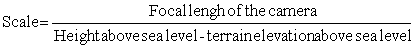
The ground coverage of aerial photographs is dependent on focal length of the camera and the height of the aircraft.
Microwave Remote Sensing
Microwave range lies approximately between wavelengths 1 mm and 1 metre. The microwave remote sensing has the principal advantage that it is a all-weather remote sensing technique. Microwaves can see through clouds, haze or rains.
Radar (Radio Detection and Ranging) is an active microwave sensor. Radar was developed to detect objects and determine their range (position). The principle involves transmitting short bursts or pulses of microwave energy in the direction of interest and recording of the reflected energy from the object. By measuring the return time of the signal after reflection, the distance or range of an object can be determined. Radar system may be both image forming and non-image forming. They may be ground based or space based (aircraft, satellite). The spatial resolution of a radar system is dependent on, among other things, the size of the antenna. For a given wavelength, the larger the antenna, the ligher the resolution.
SLR/SLAR
Most airborne radar remote sensing systems use antennas fixed below the aircraft and pointed to the side. These systems are termed Side Looking Radar (SLR) or Side Looking Airborne Radar (SLAR). They usually have large antenna systems and produce continuous strips of imagery of very large ground areas located adjacent to the aircraft flight line. SLAR was first developed for military purposes in the early 1950s.
SAR
As note earlier, the resolution of a microwave system will improve if a longer antenna is used. The Synthetic Aperture Radar (SAR) principle is based on the principle of 'synthetically' generating an effectively long antenna without any physical increase.
The first satellite SAR for civilian applications was on board the Seasat (Sea Satellite) satellite which was launched in June 1978. The satellite had a life time of about 100 days. Seasat had three active and one passive microwave sensors:
i) Radar altimeter, for measuring ocean topographyii) wind scatterometer, for global wind mapping
iii) SAR, for regional & large scale high resolution surface imaging.
iv) SMMR (Scanning Multichannel Microwave Radiometer) for measuring sea surface temperature, ocean surface wind and extraction of ice age.
SIR-A/SIR-B
The SAR of Seasat was followed by SIR-A (Shuttle Imaging Radar), the first of the three shuttle missions. SIR-B was launched in 1984. Bangladesh participated in SIR-B data calibration. The SIR-C is scheduled for 1994.
ERS-1
The European Space Agency (ESA) launched the ERS-1 (European Remote-sensing Satellite) on July 17, 1991. This satellite has SAR. ERS-2 is to follow in 1994.
JERS-1
Japanese Earth Resources Satellite (JERS-1) launched on February 11, 1992 also contains a microwave instrument SAR.
MOS-1
As already mentioned, MOS satellite also has a microwave instrument.
RADARSAT
The Radar Satellite (RADARSAT) of Canada, scheduled for launch in 1994 will also be a microwave satellite.
ADEOS
Advanced Earth Observing Satellite (ADEOS) of Japan will follow the MOS and JERS in 1996. This will also be a microwave satellite.
Unlike visible and thermal sensors, the microwave remote sensing application may be said to be still in the R & D stage. But it can be said almost unequivocally that the future of remote sensing will be the microwave remote sensing.
Table 1
|
Satellite altitude (km) |
Life before re-entry |
|
250 |
12 days |
|
500 |
10 years |
|
600 |
50 years |
|
1,000 |
1,000 years |
|
10,000 |
indefinite |
Table 2. Uses of AVHRR Channel
|
Channel |
Spectral interval |
Detection Function |
Primary use |
|
1. |
0.58-0.68 |
Reflected visible solar |
Day-time cloud and surface mapping |
|
2. |
0.725-1.10 |
Reflected near-infrared solar |
Day-time cloud & surface mapping, land-water |
|
3. |
3.55-3.93 |
Emitted thermal IR Reflected IR |
Surface temperatures extreme heat sources and night cloud maps |
|
4. |
10.50-11.50 |
Emitted thermal infrared |
SST, day/night cloud mapping |
|
5. |
11.50-12.50 |
Emitted thermal infrared |
SST, day/night cloud mapping |
Table 3. Geostationary Weather Satellites
|
Name |
Operating country |
Longitude |
|
GOES-E |
USA |
75 deg. W |
|
GOES-W |
USA |
133 deg. W |
|
Meteosat |
European countries |
0 deg. |
|
GOMS |
Russia |
70 deg. E |
|
GMS |
Japan |
140 deg. E |
|
INSAT-1D |
India |
83 deg. E |
Table 4. GENERAL CHARACTERISTICS OF THE LANDSAT SATELLITES
|
|
Launch date |
End of activity |
Orbit altitude |
Orbital cycle (days) |
Sensor |
|
LANDSAT 1 |
1972 |
1978 |
918 km |
18 |
MSS+RBV |
|
LANDSAT 2 |
1975 |
1983 |
918 km |
18 |
MSS+RBV |
|
LANDSAT 3 |
1978 |
1983 |
918 km |
18 |
MSS+RBV |
|
LANDSAT 4 |
1982 |
- |
687 km |
16 |
MSS+TM |
|
LANDSAT 5 |
1984 |
- |
687 km |
16 |
MSS+TM |
Table 5. The spectral wavelength intervals for RBV and MSS
|
System |
Wavelength (micrometre) |
NASA code |
|
RBV |
0.475-0.57 |
Band 1 |
|
RBV |
0.580-0.680 |
Band 2 |
|
RBV |
0.690-0.830 |
Band 3 |
|
RBV |
0.505-0.750 |
panchromatic |
|
MSS |
0.5-0.6 |
Band 4 |
|
MSS |
0.6-0.7 |
Band 5 |
|
MSS |
0.7-0.8 |
Band 6 |
|
MSS |
0.8-1.1 |
Band 7 |
D. A. QUADIR
Chief Scientific Officer
Bangladesh Space Research and Remote
Sensing Organization (SPARRSO),
Agargaon, Sher-e-Banglanagar,
Dhaka 1207, Bangladesh.
1. INTRODUCTION
Digital image processing is a subject that deals with the manipulation of images by computers. This technique has widely been used for processing the remotely sensed data in the digital form. The digital image processing requires special hardware and software, the collection of which is called the 'Image Processing System'.
The sensors in the space platforms scan the earth in different bands of the electromagnetic spectrum and sense the irradiated energy of the earth's surface. These data are subsequently transmitted to the satellite ground station in the digital form.
Certain preprocessing is needed to convert these data into - workable imagery. For practical purposes, it is necessary to manipulate the data in various ways as needed by the individual applications.
In the following sections we provide an overview of the image processing techniques and analysis of satellite data for environmental mapping and monitoring.
2. DIGITAL IMAGE
A digital image is a two dimensional array of integers (matrix). Each element of the matrix has a discrete value and refers to a small area with a horizontal distance (x) and vertical distance (y) which is called a picture element or pixel. The size of the pixel determines the spatial resolution of the image ie, a smaller pixel means higher spatial resolution. The position of a pixel is given by the line and column of the matrix and the integer value of the pixel represents its illumination or brightness. For most of the digital image the pixel values are represented by 8 bit number which produces 256 levels of gray scale.
The digital image stored in the computer is displayed on the display device, printing device or photographic films for human perception. The brightness distribution of the visual image is dependent on the gray values. The value zero means no illumination (black) and the value 255 means the maximum illumination (white).
In case of the satellite imagery, the pixel corresponds to the small area on the earth's surface which is covered by the Instantaneous Field Of View (IFOV) of the sensor. The satellite sensors collect information from every such small area to make a whole image.
3. DIGITAL IMAGE PROCESSING
The image processing system is a collection of hardware and software having the facilities for input, processing and output of the digital images.
The multispectral satellite image processing and analysis highly depend on the nature of the application and also on the data to be used. The following image processing techniques are generally used for application of satellite imagery to various environmental mapping and monitoring.
The image processing functions which are commonly used for analyzing the satellite imagery are described in the following subsections.
3.1 Radiometric processing
The radiometric processing involves the following:
- Calibration of the digital counts produced at the sensor to an understable geophysical unit like irradiation (watt/m2-sr), percent reflectance or albedo and in the case of thermal radiation to the black-body temperature (°K)- Correction for atmospheric absorption and scattering
- Sun-angle correction
- etc.
3.2 Geometric processing
Because of the earth's rotation, the satellite orbit makes an inclination with the true north. Moreover, the image captured by the satellite sensor is the projection of the curved surface on the two dimensional plane.
Thus the geometric correction of the satellite images is to be done to convert the image geometry to a preferred cartographic projection. For the data of environmental satellites like NOAA - AVHRR, the geometric correction is commonly done by the orbital information of the satellite and the characteristics of the sensor. For the high resolution data from Landsat MSS, TM and SPOT - HRV and panchromatic, the geometric correction is done by referencing the image to the ground through a set of ground control points. The ground control points are obtained from the maps using a digitizer or from the measurements of Global Positioning System (GPS) at the ground.
The geometric correction is done by transformation of the coordinates of the original image to the new coordinates which is defined by the ground control points. The new points are expressed as functions of old points:
X = f1 (x, y)
Y = f2 (x, y)
The other functions that include the geographic processing are image rotation, displacement and image enlargement.
3.3 Image Enhancement
A digital image from the satellites may be enhanced to increase the contrast among the various features. In the initial step, the histogram of the intensity distribution is calculated. For a low contrast image, the histogram is concentrated within a small region of the gray scale. The principle of the contrast enhancement is to distribute the gray values of the original image to the full range of the gray scale ie, from 0 to 255. The following enhancement schemes are generally used for increasing the level of contrast.
Linear contrast stretching
The linear contrast stretching technique involves the mapping of the pixel values from the observed range to a output range specified by a linear transfer function.
Scaling of the histogram
In this technique the observed histogram is scaled over the whole range of the gray scale, where the overall shape of the histogram remains unchanged.
Histogram equalization
In this sophisticated technique, the histogram is distributed over the whole range of the gray scale (0 - 255) in such a way that each class in the output image has approximately the same number of pixels. In this process, the lower populated gray values at the beginning and at the end of the histogram of the input image are amalgamated to a fewer number of classes and the highly populated classes are placed away from each other for increasing the contrast. The histogram of the output image have more or less uniform distribution of pixel population.
Gaussian stretch
The gaussian stretch technique involves the fitting of the observed histogram to a normal gaussian histogram following the distribution defined by
f (x) = C e-ax 2
where C = (a /p)0.5 and a = 0.5 d 2
d is the standard deviation of gray values of the image.
Piece - wise linear transformation
For some applications, it is needed to enhance the image by breaking the histogram into pieces and then applying the linear transformation on each part of the observed histogram, separately. Some of the image processing systems provide the facilities to enhance the image by the user interactively using trackball or mouse-button.
Stepwise transformation
The input image histogram may be transformed stepwise using a user - defined lookup table to a fewer number of classes. Sometimes a binary transformation of the input image is made at a user specified break point. In the transformed image there are only two highly contrasting gray levels.
Colour Enhancement
There are many techniques for colour enhancement of the imagery of which pseudo color transformation, density slicing and user defined colour transformation are common. The user interactively determines which of the colour enhancement is suitable for his work. Each provides a method for mapping from one dimensional gray scale to a three dimensional colour space defined by Red, Green and Blue axes. There are two colour models used for colour transformation, one is RGB colour cube model and the other is HSI model where RGB stands for Red, Green and Blue and HSI stands for Hue, Saturation and Intensity.
Density slicing
In density slicing, the histogram is divided into a number of classes or slices and the range of contiguous gray levels in each class is mapped to a point in the RGB colour cube.
Pseudocolour Transformation
A pseudocolour transformation is carried out by setting the three look up tables (LUT) (red, green and blue) from the observed one dimensional gray scale. Red - LUT corresponds to certain range of the input histogram along the one dimensional gray scale, Green - LUT corresponds to next range of gray scale in the histogram having some overlap with earlier range and Blue - LUT corresponds to the third range covering the rest of the gray scale having an overlap with its earlier one. After the transformation using these lookup tables a three band colour image is produced. Unlike the density sliced image, each pixel of the pseudocolour image has a discrete colour, although difference between 80% red and 85% red may not be physically discriminated in reality.
User - specified colour transform
In density slicing the user have the provisions to choose the classes and the colours for the respective classes. Say, for example, for mapping a warm surface, naturally the user would like to use red for the hottest class and yellow for the intermediate class and so on. Pseudocolour transform similarly provides the facilities within the image processing system to set the LUTs to convert the one dimensional grayscale to a colour representation of an image. The user can choose its own transform by changing the shape of the LUTs. Then the colour scheme is saved in the disk which may be repeatedly used when necessary. The user may produce the colour schemes for individual applications once for all and use the same any time it is needed.
4. MULTISPECTRAL AND MULTITEMPORAL IMAGE PROCESSING
Previous section has dealt with operations such as enhancement which are applied to single band images or separately to single bands of a multiband image set. In this section, we deal with operations on multiband images which may consist of a single multispectral image of a particular area or a number of images of the area taken at different times.
The multispectral image processing mainly consists of the following:
- False colour composite (FCC)- Arithmetic operations between the bands or between the images of the same area.
- Multispectral classification
- Binary operations between the classified imagery of different times
- Calculation of image statistics
- etc.
The multispectral image processing depends on the kind of application and type of data used.
4.1 False Colour Composite
When 3 bands of a multi-band image are displayed in the monitor in the red, green and blue colour planes a False Colour Composite (FCC) image is prepared. Then the individual bands may be enhanced to increase the contrast of the image and bring up the features on which the user is interested. In a standard FCC, the near-infrared (NIR) band is displayed as red, the red band as green and green band as blue. As the vegetation has high reflectance in NIR band and low reflectance in the visible bands, it appears red in the standard FCC product. Bare soil has nearly same reflectance in all the bands and thus it appears dark to bright gray depending on the type of soil and moisture content. The drier soil appears brighter. The water absorbs almost all the radiations in NIR, while the visible light is partly reflected by the suspended sediment (or from the bottom of the shallow coast in case of clear water). Thus the turbid water seems blue in the enhanced FCC. The deep water with low suspended sediment appears dark.
For the Landsat MSS which has 4 bands, namely bands 4, 5, 6 and 7, the standard FCC is composed of bands 7 (red), 5 (green) and 4 which correspond to the false colours red, green and blue respectively. For Landsat TM, the same is done using the bands 4, 3 and 2. But there are other applications which might require the band composites with different other combinations. The LUT of the FCC enhancement schemes are saved and may be used if and when needed. The high quality photographic negatives or positives films and hardcopy paper products are produced in a definite scale. These imagery are then interpreted visually for landuse mapping/environment monitoring purposes.
The FCC of AVHRR bands 2, 1 and 4 represents the green vegetation as red, bare soil as light gray, coastal turbid water as green and clear water as dark.
4.2 Arithmetic operations
Arithmetic operations among the individual images or of one image with other images or constant numbers can be performed. Addition, subtraction, multiplication, division and logical operations or any other arithmetic operation may be performed as per user's need. The arithmetic operations are carried on pixel to pixel. For example:
C (x, y) = A (x, y) + B (x, y)
This means, the values of the pixels of the resultant image is obtained by adding the values of the corresponding pixels of images A and B. More clearly:
C (1, 1) = A (1, 1) + B (1, 1)
C (1, 2) = A (1, 2) + B (1, 2)
.
.
.C (m, n) = A (m, n) + B (m, n)
The mean of two imagery is given by
P (x, y) = {A (x, y) + B (x, y)}/2
The image operations of the type,
S (x, y) = a x A (x, y) + b x B (x, y) + C
can also be performed where a, b and C are constants. Some more examples are given below:
Image multiplication: M (x, y) = A(x, y) x B(x, y)
An example of algebraic expression of image manipulation:
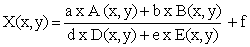
where a, b, d, e and f are constant.
4.3 Vegetation indices
Besides the visual interpretations using FCC products as discussed in section 4.1, the digital data can be analyzed and interpreted using suitable arithmetic manipulations. Such digital analysis and interpretation begin with examination of the digitally enhanced FCC and the image statistics corresponding to the prominent features. Let us pick some samples of vegetation, bare soil (dry, medium, wet), water, etc. on the FCC image and calculate the mean, standard deviation and histogram of the individual classes. We draw the spectral information of these classes in a two-dimensional scatter-diagram with Red band as X-axis and NIR as Y-axis. It may be seen that the pixels are distributed around two lines: the soil line and the vegetation line. Approximately these two lines are orthogonal.
From this scatter-diagram, it is evident that the vegetation have high reflectance in NIR compared to soil and water and low reflectance in RED band. From such a diagram it may be envisaged that the ratio of NIR and RED bands would separate land from water and enhance the vegetation information. Such a ratio is called Ratio Vegetation Index (RVI) and is given by:
The interpretation of RVI is as follows:
|
RVI < 1 |
Water |
|
2 > RVI > 1 |
Bare soil or soil with low coverage of leaf area |
|
RVI > 2 |
Green vegetation; the higher the RVI, the more is the green vegetation coverage. |
Higher the value of RVI, higher is the leaf-area coverage. RVI saturates nearly at the value 5.
Another vegetation index is called Normalized Vegetation Index (NVI). The NVI is expressed as:
The NVI is explained as the following:
|
NVI < 0 |
Water |
|
NVI > 0 |
Land |
|
.2> NVI > 0 |
Bare soil or soil with lower coverage of vegetation |
|
NVI >.2 |
Green vegetation. Higher the NVI value higher is the vegetation coverage |
The percent coverage of vegetation is dependent on the NVI value. The higher the NVI the higher is the vegetation coverage. The NVI is limited between -1 to +1. However, the NVI saturates at around 0.6.
The IR band corresponds to band 7 of MSS, band 4 of TM and band 3 of SPOT-HRV, and Red band corresponds to band 5 of MSS, 3 of TM and band 2 of HRV. The RVI and NVI may be calculated for each of the setypesof satellite data following equations 1 and 2. For better recognition of land water boundaries bare soil and different levels of vegetation coverage, the vegetation index imagery are colour coded using a predefined colour scheme. Such images of vegetation indices are then used for crop monitoring, preparation of vegetation maps, determination of green biomass, crop modelling, water-bodies survey, etc.
4.4 Image classification
Multispectral classification is a technique for automatic classification of the spectrally different features. The classified image is digitally interpreted using the classification statistics, scatter diagrams and the ground truth information. There are two general techniques for image classification: Unsupervised and Supervised classifications.
The unsupervised classification is the one which determines the characteristics of non-overlapping groups of pixels in terms of their spectral band values. These groups are therefore known as spectral classes, and their relationship with features must be worked out through field work. The overall feature types may however be interpreted from the position of the classes in the spectral domain.
The supervised classification is carried out by taking a training set, the feature relationship of the training set is already known. Then the statistical properties of each of the classes are studied and the pixels of the image are then allocated to one of those classes using a classification algorithm. It is likely that a number of pixels will not find their similarities with any of those classes or groups and will remain as unclassified.
There are several classifier algorithms of which the maximum likely hood and minimum distance classifiers are most common. The software packages provide many classifier algorithms, however, it is up to the user to decide which one of those is to be used.
The digital classification is a standard practice of the users of remote sensing techniques for analysis and interpretation of imagery and the interpreted results are produced as landuse/resource maps and also as tabular information. A properly geo-referenced and classified image with appropriate heading, legends and other required annotations can be transferred as the hard copy photographic product in a chosen scale.
The classified imagery at different seasons are used to remove the effects of interference between the various features, Say, for example, we have classified the Landsat TM image of February 27, 1991. Our objective was to identify the winter rice. But some of the rice areas were confused due to the presence of wheat, shrubs, forests and home-stead vegetations. For solving this problem, we chose the December 26, 1990 image when most of the fields were vacant. In this image, the wheat, mustard, pulses etc. were identified quite successfully. The home-stead vegetations and the forest vegetations and the shrubs were also identified. A detailed ground truth data was available for this winter. The December image was classified successfully using the supervised classification technique. Then the February image was also classified. These two classified images were then used to remove the confusions of rice with other classes of vegetation.
5. CONCLUSION
An overview of the satellite data processing and image analysis has been given in this paper. For the purpose of image processing, a digital computer, image processing hardware and software and the input and output devices are necessary. Without one or the other, it is not possible to use this technology satisfactory.
In SPARRSO, there are a number of powerful image processing systems (IIs system 575 and 600 and PC ERDAS) which allows lots of image processing activities. SPARRSO's image processing capabilities can be used to conduct the country-wide mapping and monitoring of the environment and resources using remote sensing techniques.
The joint use of digital image processing and GIS enhances the user capabilities to conduct remote sensing studies reference to other spatial information.
SOME BIBLIOGRAPHIC REFERENCES
|
1. Castleman K. 1979 |
Digital Image Processing Prentice-Hall Signal processing Series, Prentice - Hall, INc, Englewood cliffs, New Jersey. |
|
2. Colwell, R.N. 1983 |
Manual of Remote sensing, American Society of Photogrametry, Falls Church, Virginia. |
|
3. Gonzalez R.C. and Wintz P. 1977 |
Digital Image Processing, Addison Wiley Publishing Company. |
|
4. |
Image Processing System, IIS System 600 (reference manuals), International Imaging Syste, Milpitas, California. |
|
5. Mather P.M. 1987 |
Computer Processing of Remotely - Sensed Images - An Introduction, John Wiley and Sons, 352 p. |
|
6. Quadir D.A, Ali, A. and Hue, O.K. 1989 |
A study of vegetation pattern in Bangladesh with AVHRR data, Asian-Pacific Remote - Sensing Journal vol., number 2 pp. 37-57. |
D.A. QUADIR
Chief Scientific Officer
Bangladesh Space Research and Remote Sensing Organization (SPARRSO), Agargaon, Sher-e-Banglanagar, Dhaka 1207
Bangladesh.
1. INTRODUCTION
Before going to detailed discussions on the Geographic Information System (GIS), let us give a thought on what 'geography' means. In the classical sense, the word geography may be defined in terms of its constituent parts: geo and graphy. Geo refers to the Earth and Graphy indicates a process of presentation or writing. Thus in this literal interpretation geography means writing about earth. Another definition of geography focuses on man's relationship with the land. In more complete sense the geography deals with earth's features, objects, phenomenon or any other information which are spatial in character. A key tool in studying and presenting this spatial information is map which contains an abstract representation/portrait of the real-world features of the earth on a two dimensional flat surface, more-commonly a sheet of paper which can be easily handled. Naturally a real-world geographic feature, when transferred on a map, is scaled down by a factor called the scale of the map, so that the real-world surface of interest can be accommodated on the choosen sheet of paper. Thus the scale of the map is a very important map feature.
A map contains the following:
- Spatial data of one or more themes.- dots, lines, polygons and symbols describing the features.
- Captions: Title, Legends or Keys.
- Textual information or attributes of the Geographic features.
- Map projection, Map scale and Tics showing the geographic co-ordinates along the border of the map.
A real-world consists of many information that are represented by maps. A collection of such maps used for preparation of a development plan may be called an analogue system of geographic information. But a GIS is certainly more than that.
2. Geographical Information System
A GIS is a hardware and software for solving complicated problems dealing with spatially referenced data. The modern GIS may be defined as:
An organized collection of computer hardware, software and personnel designed to efficiently capture, store, update, manipulate, analyze and display all forms of geographically referenced information. From experience, it can be emphasised that such an accurate and comprehensive definition of GIS might not help the new comers to GIS a great deal. Its meaning becomes clear when some one learns and works closely with a GIS for solving definite problems.
Many widely used computer programmes, such as spreadsheets (e.g. LOTUS 1-2-3), statistical packages (e.g. SAS) or drafting packages (e.g. Auto-CAD) can handle simple geographic or spatial data. Why, then, are they not usually thought of as a GIS? The generally accepted answer is that a GIS is a GIS if it permits spatial operation on data. The geographic information in a GIS consist of the spatial data and the corresponding tabular data connected by common IDs. A complete data base of a particular feature is called coverage.
The Geographic Information System have the potential for improving our understanding of the world around us and perform the planning and decision making activities on the land use, environmental and resource monitoring and management, etc. More efficiently and intelligently. The measurement, mapping, monitoring and modeling of environmental features and process can be enhanced through the use of a GIS. The geographic information processing begins and ends with the real world. Data is collected from the real world (project area), preprocessed and processed in a GIS for a definite decision making purpose and the results are applied on the project area for the subsequent activities relating to development.
3. COMPONENTS OF GIS
Several components constitute a GIS. They are
- Hardware- Software
- Data
- Basic procedures
- A well defined project
- People (Project Manager, GIS system Manager, GIS Experts, User Scientists/Engineers and Maintenance team)
The collection of hardware required for establishing a GIS is shown below:
- Computer
- Diskdrive
- Interactive graphics Workstation
- Tape drive
- Digitizer
- Scanner
- Printer
- Plotter
A full GIS implementation may take all the previously gained knowledge of the software, methods and problems and organize them into efficient, easy-to-use techniques and interfaces. It is worth noting that no single component by itself produces a fully-functioning GIS.
4. DATA STRUCTURE IN GIS
Geographic features on a map are represented as: points, lines and polygons. Some times it becomes useful to make a representation of a truly three dimensional surface, such as elevation data set. However, the representation of space in two dimensions, such as administrative boundaries of Bangladesh, are more common.
The contents of the spatial data base is a model of the Earth. Points are used to represent objects whose dimension is too small like tubewells, electric poles, market place, railway stations, etc., lines are used to represent the roads and streams and polygons are any region enclosed by lines (closed surface) that represents uniform features like water areas, agricultural lands, forests.
Besides the geometric data the attribute data characterizing the spatial data are also important.
There are two broadways of organizing the spatial data in a GIS: raster and vector data structures. While any spatial data can be expressed in either raster or vector format, but for the data representing a truely three dimensions surface, the raster format is treated to be suitable one.
4.1 Raster data structure
In raster format, the spatial data is represented by regular cells of uniform shape and size where the attribute value is located at the centre of the cell. The raster data consists of the arrays of such cells, called the picture element or pixel each of which has a position and a value representing the feature. The elements of the rows are called the samples and are numbered from the left to the right. The rows (some times called lines) are numbered from top to bottom. Thus the upper left corner of the raster file is considered as the origin and represents the first sample of the first line (1, 1).
For a raster data base, the accuracy of the measurement is limited by the size of the pixel. The smaller the pixel size, the higher is the spatial accuracy. In this data structure, the points can not be located exactly, it belongs to either one cell or another and there is nothing in between. More-over, a point belonging to any location of the pixel is attached only with the centre of the pixel. More commonly used tessellations of the raster structure are the square cells, where the neighboring cells are not equidistant because the diagonal cells have higher distance. Other tessellations of the raster structures are regular squares, triangles and hexagons. In hexagonal tessellations, the cells are equidistant. However, the use of a hexagonal or even a triangular data structure create two problems. First, the cells can not recursively be subdivided in to smaller cells of the same shape as the original cells, as in the case of square system. Conversely, a hexagon made up of smaller hexagons will not be the same shape as those smaller ones.
The individual cells of the data base does not commonly refer to the real-world coordinate, but may be georeferenced using a ground control point file where the real-world positions corresponding to the same locations at the raster data base are registered. Occasionally a raster data base has a corresponding header file which contains the coordinate of the upper left corner, cell size in X and Y directions, map projection and number of overlays.
The examples of raster data base are: Digital Elevation Model (DEM) and computer classified satellite data.
4.2. Vector data structure
In a GIS having a vector data structures, The X value and Y value of each point is encoded; together these are the (X, Y) coordinate pairs in a two-dimensional rectangular coordinate system. Thus the geographic features: points, lines and polygons are represented as follows:
- Points such as wells, telephone poles, archaeological sites etc. are represented by pairs of X and Y coordinates (X, Y).- Line features such as streams, streets, etc. are represented by a number of line segments called arcs constituted by a streams of such coordinate pairs. Starting and ending of a line segment or arc is designated as nodes. Each coordinate pair of the arc is called a vertex. The line features are displayed by joining the vertices together.
- Polygon features such as soils, landuse, water-bodies, administrative boundaries, etc. are represented by a stream of vertices enclosing a particular surface. In another word a polygon may be constructed by one or more arcs.
Each of the features in a GIS is identified by a unique ID. Lines and polygons are displayed by joining the vertices.
4.3. Concept of Topology
The spatial data in some of the GIS are topologically linked which makes geographic data intelligent. 'Topology' determines the relationship between the spatial objects. The topological relationships have the following basic characteristics:
- Arcs join at nodes.
- Arcs join to make polygon.
- Arcs have directions (From-node to To-node) and 'left' and 'right' sides.
Topology helps to store data more efficiently, process larger data set, process data faster, combine adjacent polygons with similar characteristics and overlay geographic features. The topology of point, line and polygon coverages are different and each topology are built separately in a GIS like ARC/INFO.
Some of the topological features are given below with particular reference to ARC/INFO - GIS of ESRI.
- Arc-node topology tells which arcs are connected to each other- Polygon-arc topology tells which arcs make up a polygon Left-right topology tells which polygons are adjacent to the arcs
A GIS coverage consists of geographic features topologically linked and their associated attributes stored in an automated map. A coverage have the following features:
- Tic that links coverage to the real-world coordinates. In another word Tics may be referred as ground control points.- Arc - Node - Feature IDS - Label Points at which the Label - Ids are positioned - Polygons - Annotations
4.4. Attribute data structure
Feature attribute tables are the dBase data files which have specific items relative to the spatial data base. The spatial data base together with this attribute data base is called a coverage. Every coverage has a feature attribute table which is automatically created when topology is created. The default attribute items are the same within each feature types (points, arcs or polygons) but additional user defined items can be added.
4.5. Layer concept in GIS
For most applications data base of the project area is created with many features and each feature type is stored in a separate coverage. The coverages are geometrically registered and have the same tics and boundaries and are called data layers. Such layers of spatial data describe many geographies of the real-world and allows complicated spatial, logical and arithmetic operations among the data layers to obtain totally new knowledge or develop environment models which were not possible before the development of computer based GIS technology.
4.6. Link between geographic features and attributes
In a GIS the geographic features and attributes are linked. The spatial data and the attribute data are related through the unique ID of the feature. Thus ID is stored in two places - with coordinate data and with attribute data (in attribute table).
An additional attribute data base can be created and linked to the attribute table of the GIS-coverage via a common item.
5. GIS FUNCTIONAL ELEMENTS
There are five functional elements that a GIS must have (based on Knapp, 1978 and Jeffrey Stone and John Estes 1980). These are data acquisition, preprocessing, data management, manipulation and analysis and product generation.
5.1. Data Acquisition
Data acquisition is the process of identifying and gathering of data required for application. This may be done though a number of procedures. One procedure might be to gather new data by preparing maps of required features using satellite observations, aerial-photographs or field observations. The another procedure of data acquisition is to locate and acquire the existing data in the form of maps, aerial or ground photography, surveys reports and documents. A GIS is of no use unless the relevant data has been identified, located and acquired.
5.2. Preprocessing
The preprocessing consists of the following:
- Check the quality of the source data.
- Data entry: spatial and attribute data
- Digitize a map
- Scan a hard copy document
- Use the key board to enter coordinates
- Buy data in a commercial format (e.g. diskette, tape) and load it in your computer.
- Obtain digital copies from another department or agency.
- Enter attribute data from the key board
- Use existing files already on the computer
- Read existing data stored on tape, cartridge or diskette.
- Error Detection and Editing
- Edge matching
5.3. Data management
Data management consists of storage, delection and retrieval of data. In most larger installations the data is managed by a system's administrator. If the works in the computer is done without managing the data, at one time a message will appear "DISK IS FULL". At the end of the day it is always good to delete the unnecessary files without pileing these up and take a complete backup of the work that has already been done. A large volume of data storage is to be well indexed and managed.
The data base management systems (DBMS) with the GIS may be of additional help in managing the attribute data base. A data base management system is the software that permits one or more users to work efficiently with the data. The essential components of the system must provide the means to define the contents of a database, insert new data, delete old data and ask about the contents and modify the contents. The DBMS may be used to create additional data base relative to the spatial data.
5.4. Data manipulation and analysis
The data manipulation and analysis in a GIS mainly consists of the following operations:
- Spatial operation: proximity analysis (buffering around a feature), neighborhood analysis, routing, classification and chloropleth analysis, spatial operations using logical selections based on the attribute data items and modification of the spatial data by any other maens.- Logical, arithmetic and statistical operations/analysis of the attribute data.
- Modelling using GIS data base.
- Create overlays of coverages with different features. The output coverage contains the spatialand attribute information of the input coverages.
5.5. Product Generation
Finally the results obtained from the GIS processing, manipulation and analysis are presented in the form of maps and tables. The production of the maps are interactively done in the monitor and a plot file is created after the finalization of the map composition. The plot file is sent to the plotter or printer for creating the hard copy output.
6. REMOTE SENSING AND GIS
Remote sensing is the technology that has close link to the geographic information systems. The aerial photographs contain detailed information about the earths resource, environment and landuse which are interpreted for preparation of various thematic maps. These maps are then used as input to the GIS. The imagery from the satellites also produce similar spatial information which can be linked to GIS. In both these cases remote sensing represents a powerful technology for providing the input data for measurement, mapping, monitoring and modelling within GIS contex. In most practical sense, it is believed that neither remote sensing of earths resources nor geographic information systems can reach their full potential unless the two technologies are fundamentally linked.
The remotely sensed data in the digital form are the spatial information in the raster data structure. The image processing systems handle multispectral raster data and process or manipulates the data using various techniques for producing useful thematic information. The image processing and interpretation of these data require additional information (such as elevation, landuse/landcover) to achieve high levels of thematic classification accuracy, which naturally brings us to work in the GIS environment.
The remote sensing is the major source of input data to the GIS. When working simultaneously with an image processing system and a raster GIS it is easy to move data between them. Once the remotely sensed data has been converted to a meaningful data type, transferring this data to raster GIS is relatively simple. Header and trailer records or files may need to be modified during the conversion process.
More work is involved when transferring the raster data derived from remote sensing systems to a vector based GIS. A few image processing softwares provide the facilities of raster to vector conversions and so does a few GIS as well. The US system 600 has the capability of raster to vector and vector to raster conversion reference to some particular GIS systems. The ERIM-GIS of SPARRSO in the raster based one having some capability of vector data handling. A key area in the joint applications of remote sensing technology and geographic information systems is to make historic analysis and identify changes. Remote sensing provide an excellent tool for detecting change, while a GIS is perhaps the best analytic tool for the quantifying the process of change and conduct indepth study of the process as a function of space and time.
7. PROJECT SEQUENCE
For successfully completing a GIS project, it is necessary to follow a sequence of activities which are discussed here. Prior to going into the GIS business it is necessary to formulate the objectives of the GIS project, identify the required data and locate the sources of data. It is also required to prepare a considerably elaborate working plan and proceed step by step following this work plan. All the activities are to be well documented to avoid the confusions. At the end of the day a complete backup of the work is to be taken so that your data is not lost due to any reason. The sequence of GIS activities are described below:
Build the data base
- Create work space for the project
- Design the data base structure
- Input spatial data (digitize or online ingest)
- Edit and create topology
- Input attribute data
Manage and manipulate the data
- Transfer the data from digitize coordinate to real world coordinate
- Join the coverages created from the series of mapsheets covering the study area.
- Create overlays of individual coverages
- Clip the areas of interests for analysis is required based on clip-coverage
Analyzing the data
The analysis of the data is done according to the requirement of the project. Depending on the objectives, a processing and analysis plan is to be worked out. This will make the job easier. Sometimes it is recommended to write a programme or a number of programs using command language to run it sequentially to complete the processing works. The analysis comprises of both spatial and statistical manipulations.
Presentation of the results of analysis
The final step of the GIS project is the presentation of the results of analysis. Generally, this consists of production of high quality maps and tables containing the output results of the GIS. The hard-copy of these products are taken for ultimate use and preparation of the report.
8. CONCLUSION
It may be concluded that GIS is an important modern tool that handles spatially referenced data for monitoring, management, modelling and decision making purpose. The function of GIS in an organization is manifold. Prior to setting up a GIS for a particular objective, it is necessary to gather the experience of other people and organizations who have already installed and used GIS. The major problem in setting up and operate a GIS in Bangladesh comes from the scantiness of the reliable data and lack of hardware maintenance facilities in the country.
There are many different GIS presently being used in Bangladesh. In SPARRSO we have mainframe and PC ARC/INFO, IDRISI, and ERIM-GIS. Besides, there are a number of image processing systems US operating microvax 3400 and VAX 11/750 computer and a PC-Erdas. SPARRSO has a data base of a good numbers of remote sensing imagery in the CCTs as well as negative hard-copy films which are used for different environmental and resource applications and also act as valuable input to the GIS.
For avoiding duplication of digitization there should be a good up-to-date inventory of the GIS data base created at different departments in the country so that the data may be exchanged among the departments. For this purpose, the a standardization of data from the various sources and data bases is to be setup and the convertibility of data in different formats are to be worked-out to facilitate the GIS applications in the country.
9. Bibliographic references
Calkins H. W., and R. P. Tomlinson 1977 Geographic Information Systems: Methods and Equivalent for Land Use Planning. International Geographic Union Commission on Geographical Data Sensing and Processing. Resource and Land Investigation (RALI) Program, U.S. Geological Survey, Reston, Virginia.
Chowdhury A. M. and D. A. Quadir 1993 Data-base Management and Geographic Information System (GIS): Monitoring Adjustment and Poverty in Bangladesh (CIRDAP Project), Report submitted to CIRDAP, Bangladesh.
ESRI 1991 Understanding of GIS: ARC/INFO Method. Environmental System Research Institute, Inc. Redlands, CA, USA.
Meaden G. J. and J. M. Kapetsky 1991 Geographical Information Systems and Remote Sensing in Inland Fisheries, Technical Paper-318, Food and Agricultural Organization of the United Nations.
Quadir D. A. (coordinator), M. A. Rahman, M. J. Islam, M. Nessa, I. U. Ahmed, N. Nahar and M. Hossain 1993, Monitoring of Forest Cover in Chittagong Forest Division, A Report of the Sectoral Study K under " Service Oriented Application of Remote Sensing Technology in Agriculture, Water Resources, Fisheries and Forestry Sectors" UNDP Project No. BGD/85/031
Star J. and J. Ester 1990 Geographic Information System: An Introduction, Prentice Hall, Englewood Cliffs, New Jersy.
Dr. M.A. Shahid
Principal Scientific Officer Bangladesh Space Research and Remote Sensing Organization (SPARRSO)
Agargaon, Sher-E-Bangla Nagar, Dhaka
1. Introduction
Development activities as a result of increasing population and the natural phenomena are causing serious environmental changes. Population activities include widespread deforestation, industrial and other pollution, destruction of habitat etc. while the natural phenomena worth mentioning are: floods, cyclones, storm surges, droughts etc. The current and accurate data of these environmental changes are essential for national planning and sustainable development.
The current and accurate information on spatial location, quality, quantity and their environment are essential for proper planning and sustainable management of these water areas. The traditional methods to collect these information is time consuming and require more manpower. One possible solution is the utilization of remote sensing techniques to identify and locate the fisheries resources and assess their environmental conditions.
The principle of remote sensing technology is to look down to the earth from space platforms (satellites, aircrafts, space stations etc.) to regularly monitor the earth resources and its environment. It can be applied in the field of inland fisheries and aquaculture to identify and locate the fishery habitat and man's activities is the environment to detect and predict the habitat qualities. This technique can also be used to locate and identify the different types of water bodies and to gather the information required for inland fisheries development and management (Welcome 1985). It is also possible to analyse the environmental conditions of the water areas from remote sensing data using keys from available information or existing/real time ground truths. The conventional field techniques are best suited when supplemented with remote sensing data. The surface water areas can easily be identified and categorized according to their optimum locations for inland aquaculture and culture-based fisheries using this technique in combination with the Geographical Information System (Travaglia and Klohn 1990, Meaden and Kapetsky 1991).
Realizing the importance of remote sensing technology, Bangladesh started putting emphasis on the development and use of space and remote sensing technology in the country, which ultimately resulted in the establishment of the Bangladesh Space Research and Remote Sensing Organization (SPARRSO) in 1980. SPARRSO is the national agency for application of space science and remote sensing technology in the country. It is a multi-disciplinary research and development organization involving national resource survey and environmental monitoring.
2. Objectives
Objectives of this presentation are to familiarize fishery scientists/decision makers with the capabilities of remote sensing techniques for inland fisheries development. Finally some of the application oriented activities of SPARRSO are also discussed. These will throw lights on how the remote sensing techniques are used in Bangladesh for fisheries resources inventory and environmental monitoring and ultimately helping planners and decision makers of the country.
3. General Remote Sensing Approach
Remote sensing is the science and art of acquiring information about material objects from a distance without coming into physical contact with the objects. It is a tool for the production of information presented in a statistical or cartographic form or combination of the both (Lantieri 1988). Remote sensing from satellite and airborne data provide authentic sources of information, which can be used for resources management and environmental monitoring in an effective way. One principal advantage of remote sensing is its ability to collect and analyse the multiband and multidate and/or multistage data. In a multistage sampling scheme, data are collected from different altitudes, usually at different scales and resolutions. More detailed information is obtained for progressively smaller areas as the altitude decreases with subsequent increases in the scale and resolution of the data. Interpretations and inferences can be verified in small subareas and then extrapolated to higher level of observation. Remotely sensed data collected at different dates can be used to monitor changes in dynamic natural resource features.
3.1 Data Acquisition
The selection of suitable remote sensing data is normally determined by the objectives of the study and data availability. There are two main kinds of methods to acquire remote sensing data.
3.1.1 Airborne
The data acquired from aircraft platform are known as airborne remote sensing data. Aerial photographs are the important examples of airborne remote sensing data. Advantages of using airborne remote sensing data include:
* provision of high scale,
* high flexibility for surveying an area at a precise time and at a designated scale
* possibility of flying below cloud level.
3.1.2 Satellite
Satellites are the most widely used and promising platforms for acquiring remote sensing data. These satellites are subdivided into two categories according to their altitude range and their rotation mode around the earth:
* the polar orbiting satellites (move north - south) and
* the geostationary satellites (move west - east).
Satellite based remote sensing data offer some unique advantages.
These include:
* good coverage of a larger area at a time,
* synoptic view of a given area,
* repetitive coverage of the same area at regular intervals.
Some of the important earth resources satellites with their dates for first launching are:
|
* The Landsat (U.S.A) |
1972 |
|
* The SPOT (France) |
1986 |
|
* The MOS (Japan) |
1986 |
|
* The IRS (India) |
1986 |
|
* The ERS (ESA) |
1991 |
|
* The JERS (Japan) |
1992 |
3.2 Data Interpretation
Interpretation of remote sensing data can be done either visually or digitally. Visual interpretation is normally based on the tone, colour, texture, pattern, size, shape and shadow of an image. On the other hand, digital image classification is a quantitative approach based on the brightness values of scene features and can be done with the help of a computer. Stereoscopic interpretation is another kind of photo interpretation technique and usually done with the help of stereoscopes on the photographs that can produce three dimensional views.
4. Remote Sensing Applications for Environment, Inland Fishery and Aquaculture Development
Remote sensing techniques can be applied for the development and management of inland fishery and aquaculture. Applications of this technique vary according to the degree of resolution of the remote sensing data available and also to the objectives of the study. The smallest element that can be easily identified from the remote sensing data is called its resolution. Thus satellite imagery serve primarily to obtain a broad impressions of an area, whereas various types of aerial photographs may be used for more detailed analysis of smaller areas. There is a close association between remote sensing and mapping. So, many of the applications are associated with inventory functions. On the other hand, maps tend to be fairly static documents, whereas the capacity to repeat surveys through time by remote sensing allows trends to be established and thereby they may be used for monitoring. The capabilities of remote sensing to collect information for environment, fisheries and aquaculture development may be summarized as follows:
4.1 Environmental Condition
Land use change of an area can affect the potential for inland fisheries of natural water bodies. Such activities as deforestation, irrigation, urbanization, dam construction etc. can produce radical changes within the water body which eventually affect the quality and quantity of water in the rivers and lakes. Monitoring of these changes provides information on the position of fisheries relative to other uses of the basin.
4.2 Survey of Geomorphology
The productivity of inland rivers and lakes is determined by several factors including the form of the landscape, drainage system, vegetation covers etc. The type of landscape is readily determined from Landsat imagery. It is also possible to collect information on spatial and temporal changes such as the alteration in course of river or the siltation of a series of floodplain.
4.3 Soils
Soil types can be inferred from remote sensing images both directly and indirectly. Since natural vegetation types correlate strongly with soils, hence the various vegetation categories will give a clue to the suitability of soils for pond construction or other fisheries development.
4.4 Inventory of Surface Water Bodies
Remote sensing techniques are being applied effectively for inventorying and determining the distribution and magnitude of inland waters to assess inland fishery resources. This is specially useful in areas where the number of water bodies are sufficiently large as in Bangladesh. It is also a practical method of keeping track of the number of man-made water bodies such as dams or fish ponds. Calculation of dimensions (length, breadth, shoreline, limits of seasonal fluctuation) of rivers, reservoirs, swamps, flood-plains of large river systems etc. may also be done using remote sensing data.
4.5 Productivity and Water Quality
Remote sensing data can be directly applied for productivity estimation. The chlorophyll content and temperature of water bodies are being measured from satellite data that can give immediate information on the primary productivity of a water body.
4.6 Suitable Site Selection
Site for inland fishery development should satisfy a location that is suitable for fish production. Remote sensing in combination with ground truth data and geographical information system can provide important tool for identifying potential sites for development of new aquaculture installations.
4.7 Survey Design
The first stage in the design of a survey is the establishment of a sampling frame. The frame is usually designed so as to group geomorphologically and sociologically similar units within which more detailed sampling activities can be generalized. The frame also requires the identification of specific sampling points which are often determined by accessibility. Maps and remote sensing imagery are the most useful means for establishing this frame.
There are some other production functions which can also be inferred from satellite imagery. These may include determination of water depth, identification of shelter for cage culture, estimation of temperature and sediment concentration of water, monitoring of vegetation levels or biomass estimation in inland water, existence of coastal flora or habital types such as mangroves etc.
5. Remote Sensing Activities of SPARRSO Related to Inland Fishery and Aquaculture
SPARRSO has conducted a number of studies in the field of fisheries. Some of the studies are briefly presented below:
5.1 Fishery Resources Survey
Satellite imagery and aerial photographs were used to collect information on available water bodies for fish production in the country. Methodologies used for the work included visual interpretation of Landsat imagery and stereoscopic interpretation of aerial photographs. Maps at the scale of 1:50,000 of 40 selected thanas for small water bodies (>25 ha) and whole of the country for large water bodies (<25 ha) were produced. These maps showed the location of water bodies including their communication facilities and physical situations. The results of this study were supplied to Fisheries Department of Bangladesh for their development planning and management purposes.
5.2 Standing Water Bodies Survey
Landsat imagery (dry season) and colour infrared aerial photographs were visually interpreted to identify and locate the latest position of standing water bodies of the country. Stereoscopes were used as and when needed to interpret these water bodies. Maps of the whole of Bangladesh at a scale of 1:250,000 were prepared in four parts (north-east, north-west, south-east and south west) showing the catchmentwise locations of the standing water bodies. The areas of the these water were measured and estimated to be 1922 sq. km (Table 1)
Table 1. Areas of Standing Water Bodies
|
Location |
Area (sq. km) |
|
A. North-West Region |
334.14 |
|
B. North-East Region |
748.02 |
|
C. South-West Region |
140.37 |
|
D. South-East Region |
699.14 |
|
Total |
1922.14 |
(Source: SPARRSO Report, 1985)
5.3 Hail Haor Fishery Resources Survey
Fishery resources of Hail Haor were identified and mapped using aerial photographs taken during 1952, 1963, 1975 and 1982 and Landsat imagery of 1980. Total number of ponds were counted and total area of different water bodies in the haor zone was identified and their area was measured from the map. The data of this study were found to be very useful for fishery development and management of that haor.
5.4 Kaptai Lake Study
Remote sensing data were used to study the water condition of the Kaptai Lake in different seasons. The surface area of water of that lake was found to be 74,000 ha during full inundation (October), 57,000 ha during mid-dry season (March) and 26,000 ha during peak of the dry season (May). These information are found to be useful for fish resources development and management of that lake.
5.5 Study on Seasonal Fluctuation of Water Bodies
A sectoral study was conducted under UNDP supported project to monitor seasonal fluctuations in the area of inland water by water type between the period January/February and August/October using Landsat TM and SPOT HRV data. The objectives of these study were to:
- monitor seasonal fluctuation in the area of inland water,
- show the potential capability of digital image processing of Landsat data,
- apply GIS for development and management of inland fisheries.
Visual interpretation and digital classification methods supported by ground truth information were used for this study. Unfortunately, it was found during the study that the determination of fluctuations in the area of inland water was almost impossible, as good remote sensing data for wet season could not be available because of cloud cover. However, an indirect approach of seasonal fluctuations was used for this study. Kurigram, Kishorgonj and Sunamganj districts were selected for this study. The output of this sectoral study was surface water inventory maps at the scale of 1:100,000.
5.5.1 Interpretation and Mapping
Visual interpretation of Landsat TM imagery were done on the basis of their colour, texture, pattern, size, shape etc. PROCOM-2 was used to maintain the scale of the maps. Due attention was also given on drainage patterns, landscape, vegetation cover etc. during the identification of water bodies of an area. Colour composites of Landsat TM bands 4, 5 & 7 were found most suitable for separation of water bodies from other surface features.
ERDAS image processing system of SPARRSO was used for digital classification of Landsat data, for this study. Different water bodies, vegetation, bare land, settlement area etc. were classified using maximum likelihood supervised classification method. The classified image was converted to ERDAS GIS format for using in ARC/INFO GIS application.
5.5.2 Application of GIS (ARC/INFO)
The objective of this application is to demonstrate the use of GIS technique for proper planning and development of inland fisheries and aquaculture. Part of Kurigram district was selected for this purpose. Nine layers were chosen from the final map of this area. Surface water layers allow users to select suitable water bodies according to their water type (permanent, seasonal, closed, etc). Road layers show the transportation suitability of the water bodies. Town/village layers indicate the potential markets for selling the products.
Roads, main cities/towns, permanent closed water bodies and river system were separately buffered with distance of 1 km, 5 km, 1 km and 1 km respectively. The potential ponds were determined with the spatial relationship among the permanent water bodies (as water source), roads (as availability of transportation) cities/towns (as source of manpower and potential markets) buffers. Those areas fall on the buffer of roads and permanent water bodies and that of roads and rivers are considered as the potential areas where new ponds could be constructed for fish culture. The suitable sites for new ice plants were also analyzed on the ARC/INFO system considering the spatial relationship among roads and permanent water bodies.
5.5.3 Estimation of Chlorophyll Content of Water Bodies
Phytoplankton concentration is normally determined by their green pigment (i.e. chlorophyll). The increasing quantities of chlorophyll cause water colour to change from blue to green. Presence of phytoplankton can be considered as an index of biological productivity and it can be related to fish production. The spectral reflectance of chlorophyll is quite distinctive in near infrared range. Landsat MSS and TM data along with field sampling data allow for the calibration of chlorophyll concentrations and estimation of algal front movement. An attempt was, therefore, made to find out the potential capability of digital image processing of Landsat data for estimation of chlorophyll content of water bodies. Water area of Tanguar haor in Sunamganj was selected for a case study. Unfortunately, there were no real-time in-situ data of chlorophyll-concentration for the area; as such it was not possible to make correlation between them. However, this technique can be used in Bangladesh situation if sufficient real-time data are available for water bodies like the Kaptai lake.
6. Conclusion
Remote sensing techniques can be used to obtain up-to-date, and cost and time effective information for inland fishery management and aquacultural development. The combination of satellite imagery, aerial photographs and conventional method as well as ground truth information provide one of the best ways to survey and monitor the fisheries resources in Bangladesh. These techniques in combination with Geographical Information System (GIS) can provide a unique tool for aquacultural site selection.
7. References
Department of Fisheries, 1987-88. Fish Catch Statistics of Bangladesh, Government of the People's Republic of Bangladesh, Dhaka, 26p.
Food and Agriculture Organization (FAO) of the United Nations, 1980. Twenty Year Fishery Development Plan for Bangladesh. Prepared by John C. Marr Associates of U.S.A for the People's Republic of Bangladesh, pp. 8-22.
Lantieri, D. 1988. Introduction to Remote Sensing. Food and Agriculture Organization of the United Nations, RSC Series No. 48, 49p.
Meaden, G.J. and J.M. Kapetsky, 1991. Geographical Information Systems and Remote Sensing in Inland Fisheries and Aquaculture. FAO Fisheries Technical Paper, No. 318, Rome, FAO, 991, 262p.
SPARRSO Report, 1985. Report on Standing Water Bodies of Bangladesh. Prepared by SPARRSO for Master Plan Organization (MPO), Dhaka, 83p.
Travaglia, C. and W. Klohn, 1990. Application of Remote Sensing to Water Resources Assessment and Management in Developing Countries: The Experience of FAO, In: Pro. of the Conference on Remote Sensing and Water Resources, 1990, Enschede, The Netherlands.
Welcome, R.L., 1985. Application of Remote Sensing to Fisheries and Aquaculture. In: Proc. Ninth UN/FAO International Training Courses in Co-operation with the Government of Italy on Application of Remote Sensing to Aquaculture and Inland Fisheries, Food and Agriculture Organization of the United Nations, Rome, Italy, 10-28 Sept. 1984, pp. 23-25.
Dr. M.A. Shahid
Bangladesh Space Research and Remote Sensing Organization (SPARRSO) Agargaon, Sher-E-Bangla Nagar, Dhaka-1207
1. Introduction
Bangladesh has a long coast and large areas of rich tidal lands. This coastal area offers an ideal place for aquacultural development, specially for shrimp farming due to its high productivity and availability of large number of culturable species of shrimp and fish. Presence of natural mangrove forests in Satkhira-Khulna-Bagerhat and Cox's Bazar areas provides a unique ecosystem in this coastal region. This ecosystem supports a characteristic groups of shrimps, fish, edible crabs and also carries food for fisheries upon which many coastal communities depend.
Shrimps and fish are being traditionally cultured along the coast for a long time. But now-a-days, shrimp farming areas are rapidly increasing horizontally due to steadily rising price of shrimp in the international markets. In most of the places, these expansions of shrimp farming areas have resulted in low production causing ecological and environmental problems.
The main problem for proper planning and sustainable development of coastal fisheries in Bangladesh is a crucial lack of baseline information about the physiographic environment which make it difficult to assess resources and start efficient development. The conventional methods to collect these information are time consuming and expensive and need a lot of manpower. It is very difficult to visit the coastal areas and error may crop up due to variation of different field survey teams. Alternatively, improvement of remote sensing techniques has provided an effective means to overcome most of the problems.
Remote sensing data offer some unique advantages. These are:
* good coverage of a larger area at a time,
* synoptic view of a given area,
* repetitive coverage of the same area at regular intervals
* provision of high scale data,
* high flexibility for surveying an area at a precise time and at a designated scale.
2. Objectives
The objectives of this lecture are to present the applicability of remote sensing in the assessment and monitoring of coastal shrimp farming areas of Bangladesh. This will focus on the following points:
* Overview of whole coastal zone to find out the areas with maximum shrimp farms along the Bangladesh coast,* Increasing trend of shrimp farming in agricultural and mangrove forest areas,
* Impact of spatial changes of shrimp farming and mangrove forest areas on coastal environment,
* Geographical Information System (GIS) for planning, development and management of coastal shrimp farming at sustainable levels.
3. Overview of the Whole Coastal Area
An overview of whole coastal area was made to find out the areas with maximum shrimp farms. Landsat (MSS) data of January-February 1977 and February-March 1984 were used for this study. As band 7 of Landsat MSS is water absorption band and band 5 is vegetation absorption band, therefore, imagery of these two bands were blownup to 1:1,000,000 scale for visual interpretation of shrimp farming and mangrove forest areas. Colour composites of Landsat (MSS) bands 4, 5 and 7 were also used for visual interpretation of these features. Results obtained from the study were also compared with the shrimp farming areas estimated through conventional method. These data indicated that shrimp farming areas are rapidly increasing in south-western region (Satkhira-Khulna-Bagerhat) near the Sundarbans mangrove forest and south-eastern region (Chittagong-Cox's Bazar) near the Chokoria Sundarban mangrove forest.
3.1 Increasing Trend of Shrimp Farming in Agricultural and Mangrove Forest Areas
The overview study on the whole coastal area using Landsat multispectral imagery and false colour composites showed that shrimp farming areas are increasing in Satkhira-Khulna-Bagerhat and Chittagong-Cox's Bazar regions. Some specific sites were selected from these areas for detailed study and to find out the increasing trend of shrimp farming areas over time and place. These selected areas were Paikgacha and Rampal thanas of Khulna and Chokoria and Maiskhali thanas of Cox's Bazar districts.
3.1.1 Paikgacha and Rampal Area
These two areas are located in the deltaic part of southwestern Bangladesh. Most of these areas are traversed by-innumerable rivers and were once part of the Sundarbans and are covered by dense mangrove forests. These two areas were selected to locate and measure the increase of shrimp farming area in agricultural lands. Methodology of the study included visual interpretation of Landsat MSS and TM and SPOT imagery, followed by stereoscopic interpretation of aerial photographs, computer analysis of Landsat TM CCTs and incorporation of groundtruth information. The data used in the study included black and white aerial photographs taken during February 1975; colour infrared aerial photographs taken during February 1983; Landsat data (FCC of MSS bands 4, 5 & 7) of February-March 1984; Landsat TM imagery and CCTs of October 1988, and SPOT imagery (FCC) of February 1989.
The results obtained from the black and white aerial photographs taken during February 1975 showed that there was only 1,860 ha of shrimp farming area and that all of these shrimp farms were established outside the coastal embankments by simple dyking along the riverbank. The results obtained from colour infra-red aerial photographs of February 1983 and a Landsat colour composite of March 1984, however, after comparing with ground truth data showed that the shrimp farming area had been increasing extensively inside the coastal embankment in Paikgacha and Rampal areas. A SPOT false colour composite of multisectral bands showed this expansion very clearly.
For further detailed study, three specific sites were selected. Maps were prepared showing the shrimp farming, agricultural lands settlements and water areas at 1:10,000 scale. These maps showed the situation as of February 1975, February 1983 and February 1990, as well as the increasing trend of shrimp farming areas inside the coastal embankment from 1975 to 1990, which were predominantly paddy growing land. The average rates of increase of all sites are shown in Table 1. The settlement and water areas remained almost same. Thus, it was found that the rate of increase of shrimp farming areas was high during the period from 1983 to 1990 and very low during the period from 1975 to 1983.
Table 1. Average Annual - Rate of Increase/Decrease of Shrimp/Agriculture Area for all sites
|
1975 to 1983 |
1983 to 1990 |
1975 to 1990 | |||
|
AARI (%) |
AARD (%) |
AARI (%) |
AARD (%) |
AARI (%) |
AARD (%) |
|
5.6 |
1.1 |
22.6 |
12.9 |
13.6 |
6.6 |
(Source: Shahid et al. 1990 and 1991)
AARI = Annual Average Rate of Increase (Shrimp Farm Area)
AARD = Annual Average Rate of Decrease (Agricultural Area)
3.1.2 Chokoria and Maiskhali
The Chokoria and Maiskhali thanas are located in the district of Cox's Bazar in the south-eastern part of the country. The Chokoria thana is mostly coastal plain of Matamuhuri river. A small mangrove forest is located in this thana and is popularly known as Chokoria Sundarban due to similarity of their species composition with the Sundarban mangrove forest. Maximum area of the Maiskhali thana is covered by hills and the remaining part is the coastal plain.
These two areas were selected to locate and measure the increase of shrimp farming area through denudation of mangrove forest. Methodology and data used for these areas were same as previous one.
The shrimp farm and mangrove forest areas obtained from colour infrared aerial photographs of 1983 showed that there were 3380 ha of shrimp farm and 4359 ha of mangrove forest in Chokoria thana. Among the shrimp farming areas, 2555 ha were identified in the mangrove forest of Chokoria Sundarban that were created by removal of mangrove forest. But in the Maiskhali thana only 533 ha of shrimp farming and 2586 ha of mangrove forest area were identified. Most of these forests were planted by Forest Department. On the other hand, 5612 ha and 6613 ha of salt belts were also identified in Chokoria and Maiskhali thanas respectively.
The results of further study on the Chokoria Sundarban area showed that during 1975, the whole of the area was covered by mangrove forest. But result obtained from Landsat TM data of December 1987 showed that almost all mangrove forest were denuded for shrimp farming.
4. Impact of Shrimp Farming on Coastal Environment
The results of these studies clearly indicate that the shrimp farming areas are encroaching agricultural lands of south-western region and these areas are expanding through denudabing the valuable mangrove forests in the south-eastern region.
The shrimp farming may be profitable from the economic points of view. This economic attractiveness of shrimp cultivation caused a rapid increase in areas under shrimp farming in the saline and semisaline tidal rivers of Satkhira, Khulna and Bagerhat. An uncontrolled increase of area under shrimp culture, however, does not seem to be justified. The long term effect of soil salinity should be taken into consideration.
The effect of salinity increase in south-western region has been observed in perennial trees and bushes. Trees like coconut, mango, date and palm respond immediately to higher salinity levels in the soil. Yield reductions are impressive; and it has been observed during groundtruthing that new plantations have been; failing completely. On the other hand, in areas with continued shrimp cultivation, a typical household with a kitchen garden, a pond with fresh water or a reliable tubewell, cattles, ducks and chickens become rare. The cows are reducing in number for lack of food and the remainder are shipped to polders that do not have much shrimp cultivation.
The international markets for shrimp is not a stable one as was noted in 1990. Price fluctuations render the prospects for earning foreign exchange uncertain. Nevertheless, the area under shrimp farming is increasing year after year. The present type of extensive shrimp cultivation, however, may not prove to be very beneficial to Bangladesh. Therefore, we need sustainable and scientific development of a type of shrimp cultivation that earns more and more foreign currency but with less cost to society. Shrimp cultivation could be intensified in smaller areas with a protective salinity buffer and combined with paddy cultivation.
It is now well-known that mangrove forests and their ecosystem play an important role for coastal as well as offshore fisheries and there is a direct relationship between them. The mangrove plays an apparently important role in supplying the nutrients to the fisheries of shrimp farms in the mangrove areas should be done in such a way that neither the mangrove ecosystem nor the fisheries they support are affected. Compared with other development uses, however, aquaculture appears to be the type of utilization that best preserves the ecological condition of mangrove as a biologically balanced environment.
There is possively an optimum ratio of shrimp farm area to mangrove forest area. So the farm should be constructed in such a way that sufficient mangrove litterfall is provided to sustain the biological link essential to maintain the adjacent fisheries.
International Union for Conservation of Nature and Natural Resources (IUCN) 1983, suggested that shrimp farms should not exceed one ha of pond for four ha of natural mangrove forests. But it is not constant for all the countries. Rabanal (1977) stated that in developing shrimp farm, a buffer area of at least 400 metres should be allowed between open water (sea or river) and construction of shrimp farm.
5. Geographical Information System (GIS)
GIS is an information system that is designed to work with data referenced by spatial or geographic coordinates. This technique can be used for development and management of coastal shrimp farming area in Bangladesh. The most important use of GIS is to locate suitable sites for shrimp farming and culture of fish in cage. But before operating GIS, it is better to establish location criteria relative to the known demands of the industry. The data for location criteria can be obtained from a variety of sources. Remote sensing can provide an important source of information to assess site suitability, land cover and land uses. Land uses adjacent to the site will indicate the sources of pollution and other possible water quality problems.
Because the use of mangroves and other wetlands for aquaculture is a sensitive issue, mangrove areas need to be carefully defined in the GIS data base. Remote sensing offers an exceptional opportunity to complete and update its existing mapped areas.
6. Conclusion
These studies demonstrate that shrimp farming and mangrove forest areas can conclusively be identified and located by remote sensing techniques. The Landsat (MSS) data can effectively be used to overview the surface features of the coastal area. The colour infrared (IRC) aerial photographs have provided most revealing information to delineate the shrimp farming, mangrove forest and agricultural areas. The results of these studies have provided information for changes in time frame and these have been found to be very useful in analysing spatial changes for better planning and sustainable development.
7. References
IUCN, 1983. Global Status of Mangrove Ecosystem. Commission on Ecology Paper No. 3, (Eds. Saenger, p., E.J. Hegerd, and J.D.S. Davis), International Union for Commission of Nature and Natural Resources (IUCN), 88p.
Rabanal, H.R., 1977. Forest Conservation and Aquaculture Development in Mangrove Areas. In: Proc. International Workshop on Mangrove and Estuarine Areas Development for the Indo-Pacific Region, Manila, The Philippines., p 145-152.
Shahid M.A., M.A.H. Pramanik and Shahadat Ali, 1990. Remote sensing Applications in Coastal Shrimp Farming Areas, Asian Pacific Remote Sensing Journal, Vol. 4, No. 2, p 3-18.
Shahid M.A., M.A.H. Pramanik, M.A. Jabbar and Shahadat Ali, 1992. Remote Sensing Application to Study Coastal Shrimp Farming Area in Bangladesh, Goecarto-International A multi-disciplinary Journal of Remote Sensing, Vol. 7, No. 2, p 5-13.
Md. Obaidul Quader
Principal Scientific Officer
SPARRSO, Dhaka-1207, Bangladesh
INTRODUCTION
The Bay of Bengal: It lies in the north east corner of the Indian ocean. Bangladesh is situated at the head of the Bay and other coastal states bordering the Bay are India and Srilanka on the west and Myanmar and part of Thailand on the east. The length for the coastline for Bangladesh is about 710 km.
The Bay of Bengal covers an area of 8,38,392 square miles (21,72,000 sq. km), it occupies a total volume of 13,47,335 cubic miles (5616000 cubic km) and has a mean depth of 8,484 ft (2,586m). The deep basin of the Bay of Bengal is roughly 'U' shaped and lies at depths of upto 14,764 ft (4,500 m).
All the major river systems in India, Bangladesh and Myanmar discharge into the Bay of Bengal. It has been estimated that on the average 1300 million acre feet of fresh water is discharged per annum into the Bay. The annual range of temperature is 25-30°C while the salinity varies from 20-34.5 ppt.
The territorial sea limit is 12 nautical miles measured from the base line. For all practical purposes, the territorial sea including the air space above, its bed and subsoil is recognised to be within the complete sovereignty of the coastal state. The exclusive economic zone extends to 200 nautical miles from the base line. It comes out to be 40,000 square miles for Bangladesh. In this zone, the coastal state has sovereign rights for the purpose of exploration and exploitation conserving and managing the natural resources, whether living or non living of the sea bed and subsoil and the adjacent waters and with regard to other activities for the economic exploitation of the zone such as production of energy from the water, currents and the tide. The most prominent physiographic feature of the Bay of Bengal is the Swatch of No Ground - a submarine canyon lying off the Ganges-Brahmaputra Delta. The Bay floor is characterized by a number of other topographical features also, namely the Bengal Deep Sea Fan, the Nicobar Fan, the Ninety East Ridge, Chagos-East Coast Trench and Java-Sunda Trench. Colour of water in open part of the Bay is dark blue which gradually changes to light blue to green towards the coast. Transparency is found to be 40-50m in some places. Dense turbid water is observed only in the coastal river mouth and in the upper layer and below 30m lies the clear water.
Remote Sensing Applications in Determining Parameters of Marine Fisheries Resources Marine resource development specifically fisheries development is one of the major areas demanding immediate attention. In this field work carried out in other countries have shown that remote sensing can be successfully used in mapping and monitoring of ocean features like chlorophyll content, thermal fronts, eddies, upwelling, concentration of sediments etc. For locating probable areas in the open ocean having fish schools such information is very useful. Phytoplankton pigments (Chlorophyll) an in the sea waters are the prime photosynthesizes in marine food chain which in turn terminate as pelagic or benthic newton. These data can help estimate primary productivity and information on the global carbon cycle also.
Turbidity also can be studied from satellite data which protect fish larvae from solar radiation and causes disease in the gills of fish. Migration study of eurahaline and stenohaline fish also may be made from satellite data.
Determining sea surface temperature data from NOAA satellite and their possible application in locating fish habitat in the Bay of Bengal: The Bay of Bengal offers a potential source of fisheries resources for Bangladesh. A survey previously conducted by the Bangladesh Fisheries Development Corporation (BFDC) and the FAO (1968 to 1971) covered an area of 26,000 sq. km, mostly in areas north of latitude 20°40'N and bounded by longitude 89° to 92°30'E. This survey identified four major commercial fishing grounds. However, locations of these fishing grounds are not fixed. The locations differ due to changes in physical, chemical and biological factors, so the key problem is to locate and determine the productivity of fish production areas for future development and management.
Laurs (1986) reviewed fisheries applications of satellite oceanic remote sensing in U.S.A. Silas et al (1985) stated that the 15°, 20° and 23°C isotherms are the lower normal bounderies of occurrence of albacore, skipjack and yellowfin tuna, respectively, in the Indian Ocean. Joseph and Somavashi (1985) stated that the tuna contributed to 37 percent of the catches from the research vessel 'Matsya Sagundi' in the Bay of Bengal. They also mentioned that space technology applications in this regard could be of immense help. Tuna constitutes an important shared migratory stock in the Bay of Bengal among India, the Maldives and Srilanka. Thus remote sensing techniques may play a vital role in the management of marine fish resources.
The Analysis of Multichannel Sea Surface Temperature: The NOAA-9 (AVHRR) data used in this study are high resolution, local area coverage (LAC) data, acquired over the region and received at SPARRSO's ground station. These data were formatted on CCT's and preprocessed to the 1b level of the NOAA NESDIS and SPARRSO formats. Strong and Mclain (1984) algorithm MCSST = 1.0346 T11 + 2.58 (T11 + T12) - 283.21 was used to calibrate Multichannel Sea Surface temperature (MCSST) with the data from the images listed in Table 1. 28 tapes of different dates and months of the years 1985, 1986, 1987 and 1988 were analysed using VAX-11/750 computer and I2S software. Out of these 28 tapes 5 had corresponding sea-truth data obtained from the Marine Fisheries Research, Management and Development Project, Chittagong. This permitted the verification of the satellite observations with the field data.
Table 1. MCSST data with dates and sea-truth data
|
|
Sea-truth data |
MCSST in °C | |||
|
Date of NQAA-1B tape - for MCSST |
(Time) |
(Temperature °C) |
(Latitude) |
(Longitude) |
Same location |
|
21.3.86 |
08:15 |
27.4 |
21°08' |
90°58' |
|
|
|
11:10 |
28.4 |
21°03' |
90°37' |
|
|
|
13:50 |
29.2 |
21°07' |
90°30' |
24.0 |
|
|
17:10 |
29.2 |
21°05' |
90°30' |
(CH4) |
|
14.1.87 |
19:54 |
24.3 |
22°05' |
91°01' |
25.0 |
|
16.1.87 |
13:37 |
24.0 |
21°49' |
89°30' |
24.6 |
|
29.4.87 |
08:45 |
28.8 |
23°11' |
90°01' |
|
|
|
11:00 |
28.8 |
21°11' |
89°48' |
|
|
02.7.86 |
15:30 |
29.0 |
21°09' |
91°34' |
29.0 |
|
|
19:50 |
29.0 |
21°08' |
91°42' |
|
|
02.2.86 |
07:43 |
23.0 |
20°33' |
91°58' |
26.0 |
|
|
10:03 |
25.0 |
20°33' |
92°05' |
|
This study showed a temperature difference between calibrated MCSST data and sea-truth SST data. It ranges between 0.2° and 3°C. These temperature differences are due to differences of channel, time and location on the same day. It was found that coastal water is often colder than deep sea water, but the temperature differences are small. MCSST ranges from 1° to 3°C. Only a few images of the monsoon season were analysed due to cloud cover disturbances. A warm core zone was found along Coxs Bazar and the Myanmar coast. Some interesting eddies and circulation patterns were observed in the winter MCSST data. We assume that these patterns may have some correlation with pelagic fishes in the Bay of Bengal and that in the future these correlations may be established in collaboration with the Department of Fisheries.
The pelagic fishes that are identified in the Bay of Bengal are as follows: mackrel, tuna, scad, herring, sardine, shad and anchovy. If good correlations between the locations of some of these fish and MCSST data can be made, it will be easier to locate and commercially exploit these fisheries.
Determining Chlorophyll Content of the Bay of Bengal using CZCS Satellite Data: The ocean colour is dependent indifferent materials present in the water, mainly phytoplankton and mineral particles, plus water itself. Each microscopic algae is full of a photosynthetic pigment, the chlorophyll which is green (strongly absorbing the blue light). This change in colour is detected by satellite sensors which have different bands in the visible spectrum, especially the blue band (440 nm).
The relationship between sea-surface colour and pigment concentrations forms the basis of the biological applications of CZCS data. As measures of chlorophyll-a (plus phaeopigments), these concentrations provide a quantitative determination of the spatial and temporal distributions of the surface phytoplankton biomass These data can help estimate primary productivity and provide information on the global carbon cycle.
Six CZCS local area coverage scenes of Bay of Bengal were chosen as the cloud free images available at NESDIS/NOAA archive center (Washington) for the 1978 to 1985 period. One tape was analysed at SPARRSO with VAX/11 - 750 computer and SEAPAK software. Rest tapes were analysed at NASA/Goddard Space Flight Center, Greenbelt, Maryland, USA with same computer and software. Optical disc drives and a video disc player were also used for selecting the images at Goddard. The tapes which were analysed were of Dec 3' 1979, February 1927 '82, January 2' 1983, January 13' 1983 and April 25 '85.
Result shows that Bay of Bengal has 0.1-10 mg/m3 chlorophyll content from the coast to deep sea. The coasts are more enriched with chlorophyll than the deep sea. This result has been varified with seatruth data of chlorophyll content from International Indian Ocean Expedition (Krey 1976). Average surface chlorophyll for the Bay of Bengal were 0.224 mg/m3 (Qasim 1978).
Use of Satellite Measurements in Fisheries-Aid products for fishermen: Several projects and programmes have used or are using satellite derived ocean data in fisheries-aid products which are distributed to some fishermen of USA, Japan, China and other developed countries by a variety of mechanisms, including radio facsimile transmission, voice broadcast, by mail, telephone copier and thermal chart.
Charts showing the locations of oceanic thermal boundaries are derived from polar orbiting satellites and are provided to commercial and recreational fishermen for using in locating potentially productive fishing areas associated with oceanic frontal features. High resolution infrared images from the GOES satellite and ship reports are used in the preparation of charts for waters off the Atlantic-Coast, which are distributed to fishermen and other interested users. Of particular interest to fishermen these charts show (a) the outer limit of the shelf water mass, in which many fishery species reside, and (b) the numbers, sizes and persistence of warmcore Gulf Stream rings, which can markedly alter conditions on the fishing grounds. Charts based on GOES infrared imagery are also prepared to show the path of the loop current in the Gulf of Mexico and are mostly used by recreational fishermen.
In the USA experimental ocean colour boundary charts based on CZCS imagery were distributed to US west coast fishermen. They were produced at almost weekly intervals depending on cloud conditions and cover coastal areas up to 700,000 km2 between Guadlupe Island and Vancuover Island. NIMBUS-7 CZCS passes along the Pacific coast were collected and processed in real-time, and, and transmitted by radio facsimile the following day to fishing boats. The colour boundary charts and photographs are used primarily by commercial albacore and salmon fishermen, and recreational fishermen in southern California (Laurs 1986). Sea ice forecast charts derived from Nimbus-7 Scanning Multichannel Microwave Radiometer (SMMR) and AVHRR infrared imagery are prepared for regions of Alaska and transmitted by radio facsimile to fishermen and other marine users. In Japan some fishermen use their own portable satellite receiving stations in their fishing boat. In China some remote sensing centers produce thermal charts for the fishermen using satellite data. In India also some work has been done experimentally to provide satellite data to the fishermen.
References
1. J. Krey, 1976. Phytoplankton production, Atlas of the International Indian Ocean Expedition. IOC, Institute Fur Mereskunde - Kiel University, December, P. 23.
2. Joseph, K.M. and V.S. Samavabshi, 1985. Marine Fishery Resources Survey and role of satellite remote sensing in the assessment of pelagic fisheries resources in India. Proceedings of the seminar on Remote Sensing in Marine Resources, Marine Fisheries Research Institute, Cochin, India, April, P. 1-5.
3. Laurs, R.M. 1986 Application of Satellite Remote Sensing to U.S. Fisheries. UN/IOMAC Regional Meeting of Experts, Colombo, Srilanka, Sept.
4. Qasim, 1978. Distribution of Chlorophyll-a in the Indian Ocean. Indian Journal of Marine Sciences Vol. 7, December, pp. 258.
5. Silas E.G., P.V. Pilai and U.K. Balachandan, 1985. Marine Fishery Resources Survey and Role of Satellite Remote Sensing in the Assessment of pelagic Fishery resources in India. Marine Fisheries Research Institute, Cochin, India, P 5-1, 5-2, 5-3.
M.A. Jabbar
Chief Scientific Officer
SPARRSO
1. Introduction and Background
The aim of this study was to collect data on small water bodies such as ponds using colour infrared aerial photographs of 1983 and to make a correct estimation of total water bodies suitable for aquaculture in Bangladesh. As this study is a part of the SPARRSO's project work, we had to follow a predefined guide line. These are (1) to include small water bodies such as ponds, tanks, ditches etc. having water area less than 25 hectares, (2) to divide the whole country into 4 different categories on the basis of the pond concentration, (3) to select 40 thanas from 4 different categories, (4) to prepare detail pond map of 40 thanas in 1:50,000 scale and (5) to verify the accuracy of the pond map through ground truthing.
2. Methodology
In this study the methodology was followed as under:
2.1 267 topo sheets of 1:50,000 scale covering whole Bangladesh were collected from Survey of Bangladesh.2.2 1: million scale topo sheet index maps were procured from Survey of Bangladesh and 1: million scale thana index maps were procured from the Directorate General of Land Records and Surveys.
2.3 All ponds shown in the 15' topo sheets were counted and then stratified the whole country into 4 categories on the basis of the pond concentration.
2.4 Then the stratification was converted from topo sheetwise to thana boundarywise.
2.5 Then 40 thanas were selected proportionately from 4 different categories for detail thana pond mapping.
2.6 Colour infrared aerial photographs of 1:50,000 scale were procured from SPARRSO covering areas of 40 selected thanas.
2.7 Selected 40 thana cadestal maps of 1:63,360 (1" = 1 mile) were procured from the Directorate General of Land Records and Surveys.
2.8 Finally 40 detail Thana Pond Maps were prepared in 1:50,000 scale.
2.9 Then the accuracy of each Thana Pond. Map was tested by ground truthing taking 2 per cent area of each thana on random sampling basis.
3. Stratification of Bangladesh into 4 different categories on the basis of pond concentration shown in the 15' topo sheets of Survey of Bangladesh
3.1 Detail and maximum topographical features are shown in topographical maps of 1:50,000 scale. So it is expected that maximum pond information may be available in the topo sheets. On the basis of this assumption, pond informations shown in the topo sheets were counted sheetwise and put into the Pond Index Map of 1: million scale showing all the blocks of 15' quad sheets. Then the whole country was stratified into 4 different categories on the basis of the pond concentration shown in the 15' quad sheets as under:
(1) area of high concentration of pond - above 100 ponds/15' sheet.
(2) area of medium concentration of pond - 501 to 1000 ponds/15' sheet.
(3) area of low concentration of pond - 251 to 500 ponds/15' sheet.
(4) area of very low concentration of pond - 0 to 250 ponds/15' sheet.
But our objective was to stratify Bangladesh into 4 different categories on the basis of thana boundaries. So these informations were transferred to a latest thana index map of Bangladesh in 1: million scale which was procured from the Directorate General of Land Records and Surveys where 444 thanas are shown. Now the thana index map of Bangladesh was superimposed on the pond index map prepared earlier. The thanas whose maximum area fall in one of the four categories were assigned the whole thana in that category. This way out of total 444 thanas in Bangladesh (total member of thanas in Bangladesh in 1985 are 460) 121 fall in high concentration categories, 60 in medium concentration category, 68 in low concentration category and 195 in very low concentration categories (Fig. 2).
4. Method of selection of number of thanas from 4 different categories
It was mentioned earlier that out of total 444 thanas in Bangladesh 121, 60, 68 and 195 thanas fall in high, medium, low and very low pond concentration categories respectively. They represent 27.25, 13.51, 15.32 and 43.92 per cent of the total number of thanas from high to very low category. Therefore their proportionate representations in total selection of 40 thanas came out 11, 6, 6 and 17 respectively from high to very low category.
5. Selection of 40 thanas from 4 different categories for detail pond mapping
Now each category of thana was given separate serial number. Then on the basis of random sampling method, sufficient number of thanas were taken from each category. From these randomly picked up thanas, specified number of thanas from each category were chosen after rejecting thanas whose supporting documents were not available. For better representation stratified random sampling method were also used within the same category. This way the following 40 thanas were chosen for detail pond mapping (list of thanas shown in Table-1).
Table 1. Names of 40 selected thanas for preparing detailed pond maps
|
High concentration category thana |
Medium concentration category thana |
Low concentration category thana |
Very low concentration category thana |
|
1. Birganj |
1. Daulatpur |
1. Gobindaganj |
1. Rangpur |
|
2. Joypurhat |
2. Karimganj |
2. Bheramara |
2. Kurigram |
|
3. Mohadebpur |
3. Modhupur |
3. Sailkupa |
3. Gaibandha |
|
4. Nachol |
4. Habiganj |
4. Abhoynagar |
4. Dhunat |
|
5. Baraigram |
5. Sonargaon |
5. Gafargaon |
5. Santhia |
|
6. Gaurnadi |
6. Savar |
6. Dhamrai |
6. Mirpur |
|
7. Phulbaria |
|
|
7. Bagerhat |
|
8. Nabinagar |
|
|
8. Morrelganj |
|
9. Raipur |
|
|
9. Patuakhali |
|
10. Sonagazi |
|
|
10. Faridpur |
|
11. Patiya |
|
|
11. Sherpur |
|
|
|
|
12. Kuliarchar |
|
|
|
|
13. Netrokona |
|
|
|
|
14. Tangail |
|
|
|
|
15. Chhatak |
|
|
|
|
16. Golapganj |
|
|
|
|
17. Moheshkhali |
6. Detail Pond Mapping of 40 Thanas
It is to be mentioned here that only district and sub-division boundaries are shown on the topo sheets. Thana boundaries are only available in the cadestal thana maps of 1:63,360 scale (1" = 1 mile). The boundary of the thana maps was enlarged to 1:50,000 scale using plan vario-graph. The thana boundary was then transferred to the mosaic of topo sheets required for the thana area. From these topo sheets a thana baso map was prepared by tracing out information such as prominent ponds, metalled and unmetalled roads, railway lines, rivers and canals, and prominent unchanged features etc. This thana base map was updated by incorporating all pond data from colour infrared aerial photographs of February 1983. This way all 40 thana pond maps were prepared in 1:50,000 scale. While transferring the pond data to the base map, the special care was taken to remove photographic distortion by taking many control points from the base map/topo sheets. It is to be mentioned here that colour infrared aerial photographs have much more advantages over black and white aerial photographs for identifying pond. It is known that in Bangladesh there are approximately 68 thousand villages and most of the medium and small size ponds are associated around homestead surrounded by medium and tall trees. In black and white photographs the water bodies (ponds) and permanent vegetation both appear blackish tone. But in colour infrared photographs water bodies appear blackish but vegetations appear pink tone. This way spectral and colour technology were applied effectively for accurate pond mapping.
7. Testing of accuracy of the thana pond maps by ground truth/statistical method
According to normal statistical practice 2 per cent area of each thana pond map were ground truthed for mapping accuracy determination. For convenience of location identification and time factor, 1000 yards square grid shown in the topo sheets were chosen for grid size. 2 per cent grids of each thana pond map were randomly selected for detail ground truthing. On this basis 256 grids in all 40 thana pond maps were checked through ground truthing. During ground truthing each and every pond of the grid were visited and compared with the number of ponds traced on the thana pond map. This way the percentage of mapping accuracy (pond tracing accuracy) was found out about 95 per cent.
8. Reference
Report on FAO/UNDP Project in Bangladesh contract No. DP/BGD/79/015-2/F1 (Fisheries Resources Survey System), SPARRSO Report, 1984.
Md. Obaidul Quader
Principal Scientific Officer SPARRSO, Agargaon, Dhaka-1207
Bangladesh
1. INTRODUCTION
1.1 Bangladesh is situated in the tropical region in the northern hemisphere and is bounded by north latitudes 20°34' and 26°38' and east longitudes 88°01' and 92°41'. The tropic of Cancer passes through approximately the middle of Bangladesh. Some of the areas in these range of latitudes are very sensitive to aridity. But the country falls within the active monsoon belt and receives normal rainfall from 1266 mm to 6496 mm from west to east. Eighty five percent of the total annual rainfall is in the monsoon period (June - October), 13 percent in the summer (March to May) and 2 percent in the winter (November to February).
The catchment area of the Ganges, Meghna and Brahmaputra river system is about 1.61 million sq. km. The annual load carried by these three river systems and others into the Bay of Bengal is estimated to be around 2.4 billion tons. The most of the Bengal delta (Bangladesh part only) was formed by the network of rivers and their tributaries and distributaries, numbering about 230 with a total length of about 24140 km (BBS 1981). Rainfall occurs relatively almost round the year. The huge amount of water which flows through Bangladesh to the Bay of Bengal every year, keeps the country's topographical and morphological features dynamic. So, the 30 years revision period of Survey of Bangladesh maps is considered to be too long a gap for Bangladesh. Therefore, updating of water bodies in the map by using satellite imagery would provide uptodate information on water resources in general and fisheries in particular. The water bodies are rivers, haors (tectonic depressions), baors (oxbow lakes), beels (low lying areas) and dighis (big ponds), etc.
1.1 Objective of the Study: The aim of this study was to collect data on water bodies using satellite imagery and aerial photographs and to make an estimate of total water bodies usable for fish production and irrigation facilities in the study area (Sylhet, Jessore and Natore). This study also showed the capability of Landsat TM and SPOT (HRV) data. Another main purpose of this study was to compare 1984 SPARRSO inventory of water bodies of the whole country based on infra red aerial photo and Landsat MSS data with latest available Landsat TM and SPOT data.
Due to shortage of time and manpower only three districts were selected for updating the water bodies using aerial photo and satellite data. From 1984 inventory of water bodies it was found that single band enlargement of Landsat MSS and TM data was not feasible, because of scanning and distortion of the enlarged image which hinders interpretation. So, the methodology has been changed to using infrared aerial photography as a base map with topo sheets of 1:50,000 scale and updated by SPOT digital mosaic maps of same scale. This study will also help better planning and management of fisheries resources and irrigation facilities in these three districts of Bangladesh.
1.3 Data Sources: (a) 30 topo sheets of 1:50,000 scale from the Survey of Bangladesh covering the study area, (b) Landsat TM image (9 'feb' 1989) from the National Research Council of Thailand (NRC), Landsat TM (FCC) of bands 457 which were prepared at SPARRSO, (d) SPOT mosaic print of the same scale and area of the topo sheets from the Bangladesh Water Development Board, (e) Questionnaires supplied through the Water Development Board and the Directorate of Fisheries in the study area through their contact persons.
2. METHODOLOGY
2.1 Mapping of Water bodies using infra red aerial photo and SPOT mosaic prints: The district boundary of the three districts were taken from topo sheets of the Survey of Bangladesh. All the infrastructures - roads, markets, villages, towns, and prominent structures etc. which are relevant to water bodies management were also taken from topo sheets. Then water bodies were traced from infrared aerial photos of February 1984. In this way base maps of all three districts were prepared. These base maps were updated. All water bodies and other uptodate information were incorporated from digital SPOT mosaic prints of March 1989. These prints were prepared toposheetwise into 1:50,000 scale. In this way eleven maps of three districts were prepared.
In the maps the water bodies were classified into following categories: Perennial river/canal, seasonal river/canal, perennial lake/bil/haor/baor, seasonal lake/bil/haor/baor, pond. These were identified and classified considering the drainage pattern, landuse and soil condition from the tonal variation of aerial photos and satellite images.
Other infrastructures represented in the maps are as follows: International boundary, district boundary, district/thana headquarters, mixed urban areas, villages, main road, cart track/paved roads, railways, airports, ferrries, embankments etc.
3. DIGITAL IMAGE PROCESSING AND GIS
3.1 Data load: Loading and selecting the study area were done with the module AUTOLOAD and SUBSET OF ERDAS system for a portion of Sylhet district. (Sylhet city and adjacent areas)
3.2 Geometric correction: The TM CCT containing full scene was mounted on tape drive and a portion of the study area of Sylhet district was loaded to the hard disk of the PC based ERDAS system from CCT. This raw data was needed to be geometrically corrected before digital analysis. The geo-reference point was taken using Lambert Conformal Conic grid coordinates from topographic sheet at the scale of 1:50,000. Twelve control points from the topographic maps were used which appear clearly in image such as cross roads, pond, river etc. to correct the raw data and the root mean square of the cross was less than 0.2.
3.3 Enhancement: Image enhancement is made to improve the visual interpretability of an image by increasing the apparent distinction between the features in the scene. Enhancement techniques can range from relatively simple to rather complex procedure for computer processing data, but in every case the final product is an 'Image' which is then given to be analysed and interpreted to obtain the desired information.
In the study following enhancement techniques were used. Histogram equalization: For the enhancement of the pixel value (Intensity) of water bodies and other than features.
Filtering: For the removal of noise due to the small features on the image.
Maximum likelihood classification and False Colour Composite (FCC) of bands 457 for relevant features by supervised classification technique (Fig. 2).
3.4 Determining Chlorophyll Contents in a part of Sylhet District Module used for chlorophyll estimation:
1) In Chla = 12.05 + 6.40 Ln TM2 (Lathrop and Lillesand, 1986) TM2 means Landsat TM band 2.2) Chla = A + B * ln((TM2 - TM1)\(TM2 + TM1)) + TM5 (Li. et al, 1991)
Where, A & B are constants and, TM2 & TM1 mean, Landsat TM bands 2 & 1 respectively.
With module 2 qualitative analysis of chlorophyll concentration level of the study area has been made. But their statistics could not be taken due to non availability of data with the ERDAS software. In module 1 turbidity could not be removed because of small size and shallowness of the study area.
3.4. Application of GIS.
Planning for suitable locations for increasing inland fish production is mostly carried out at various administrative levels; eg. districts, divisions or national head quarter or concerned ministry, though it might be local fisheries officers who would advice on specific sites for fish production, and who would need informations to help them with this.
An objective of this study was to show that GIS can provide rational and easy way to fulfill these requirements, especially in view of the rapid developments of low cost software and hardware.
A portion of finalized map of Sylhet district was digitized in PC based ARC/INFO system with proper available layers and attribute data. Nine layers were chosen for the map.
* Surface water layers allow users easily to locate the interesting water body and identify this type (Seasonal water body, single line river, double side river).
* Road layer shows the suitability of aquaculture fish transport and marketing and irrigation management.
* Town/Villages layer which also indicate the potential market for selling the product and population density also is an important factor for storage.
* Water bodies classified from TM data on ERDAS system and connected to ARC/INFO coverage were taken as another data source for GIS and compared with the digitized map.
Roads, permanent water bodies, villages, rivers were buffered with distance 1 km and cities buffered with 5 km. The potential ponds were determined with the relationship among the permanent water bodies (as water source), roads (as availability of transportation), cities/town (as source of manpower and markets), (Fig. 4) share areas falls on the buffer of roads and rivers considered as the potential plans where new ponds could be constructed for fish culture and iceplant for preserving the fishes.
4. RESULTS AND DISCUSSIONS:
Counting of total number of water bodies in each class was done. However, measuring of total areas of each class could also be made. Due to devastating flood of 1988 some of the areas of these three districts seem to be still inundated or partly dried in 1989 SPOT images. This creates confusion among seasonal water bodies and flood waters or soil moistures in the study area. After ground truthing this confusion had been eliminated. Some of the permanent water bodies were also confusing in low lying areas. This also has been eliminated by ground truthing. Some differences were also found in 1984 inventory and 1989 SPOT data. 30% of the questionnaires which were sent to the officials of the Directorate of Fisheries and the Bangladesh Water Development Board were returned duly filled in. These information have been given in Table (1-2). 20 sheets of SPOT image (1:50,000 scale) prints of same date covering the study area were collected from Water Development Board for rechecking before preparing the final maps. Final checking has been made with ground truthing and 11 maps were prepared. In the Sylhet areas some one line rivers/ canals are not continuous. This is due to siltation or drying up or covering with vegetation. Minimum size of 22mm ponds were considered for tracing in the map from aerial photo and SPOT prints.
Total number of water bodies in three districts areas are as follows:
Jessore: River - 6, Bil - 300, Pond - 39, Baor - 20
Natore: Rivers - 9, Lakes - 7, ponds - 179, Bil - 252
Sylhet: River - 31, Khal - 21, Bil - 633, Haor -17, Pond - 40
Digital image processing using Landsat TM CCTs of 1990 and 1991 using the PC based computer system of SPARRSO and application of GIS ARC/INFO has been made digitizing the map for a part of Sylhet. Qualitative analysis of chlorophyll concentration level has been made using the module of Li et. al (1991).
GIS study has been made in a part of Sylhet district including Sylhet town. The results show very useful information on locations of potential areas for constructing fish ponds and suitable site for iceplant for preserving the fishes.
Digital mosaic map of SPOT data is better than single or multiband TM data for mapping of water bodies into 1:50,000 scale because of its resolution. Single band MSS or TM data are not good for mapping into 1:50,000 scale because of scanning and distortion which hinders interpretations. Multiband TM data is good for chlorophyll and other water quality studies. For landuse classification TM band 457 is found to be good for digital analysis. Questionnaires on fisheries also give useful information on fish stock, fish marketing and possible water pollution in the study area. For further study following recommendations are made:
1) Areas should also be measured for each water class district wise and different classes of water bodies should also be counted separately for IR aerial photo and SPOT data from 11 maps prepared for three districts and to be prepared for future studies.2) In future studies water quality and chlorophyll concentration study should be made in the field level extensively as this data are scarcely available now.
3) Water quality studies with chlorophyll concentration using satellite data should be developed.
4) GIS should be done for the whole country showing the potential areas for fish culture and suitable site for ice plant (Cold storage) for preserving the fishes.
5. References
1. BBS, 1981, Small Area Atlas of Bangladesh, Sylhet District, p6.
2. BBS, 1981, Small Area Atlas of Bangladesh, Rajshahi District, p5.
3. BBS, 1981, Small Area Atlas of Bangladesh, Jessore District, p7.
4. Lathrop, R.G. and T. M. Lillesend, 1986. Use of Landsat TM Data to Assess Water Quality in Green Bay and Central Lake, Michigan. Photogrammetric Engineering and Remote Sensing, Vol. 52, No 5, pp. 671-680.
5. Li, J., L. Zhang, M. Jin and Q. Huang, 1991. The use of Landsat TM Data to Quantify Chlorophyll and Lake Weed. Asian Pacific Remote Sensing Journal, Vol. 4, no. 1, pp. 1-14. ESCAP, Bangkok.
D. A. Quadir
Bangladesh Space Research and Remote Sensing Organization (SPARRSO), Agargaon, Sher-e-Banglanagar, Dhaka-1207
Bangladesh.
1. Introduction
Geographic Information System (GIS) is a tool for creating and managing the computerized data base of spatially referenced data. GIS provides the facilities of geographic analysis of these data and produces high quality cartographic products. The hard copy output of the raw and processed products are then used by the users for planning and development.
In this paper, the discussions have been made on the formulation of Periodic Atlas of Structured Information on the Fisheries Resources where GIS can play a vital role. This paper will provide some outlines on the data base structure related to fisheries application as an introduction of the subject for subsequent discussions. It is anticipated that results of the mutual interactions among the participating experts on fisheries will facilitate the formulation of such atlas.
2. Data base structure
The GIS data base for the Fisheries Atlas may have two types of data: one is the statistical data corresponding to the administrative units, eg. districts, thanas; and the other is the spatial data having land-use or land feature units or line and point information lying with such administrative boundaries.
2.1 Data base relative to administrative boundaries.
Chowdhury and Quadir (1993) have discussed the tree structure of the national data base where the country (Bangladesh) is the root and the branches are regions, districts, thanas, municipalities, unions and mouzas. The data base consists of the boundaries of the administrative units and a relational data base describing the socio-economy and resources of the respective units may be created according to the need of the development activities. In the above structure of the data base, mouzas are the lowest selectable entity. However, for fisheries applications thanas may be considered as the lowest selectable entity.
The sources of data for the thanas and districts are BBS, Fisheries Department, field survey, etc.
The spatial data of the administrative boundaries are the following:
- International boundary
- District boundary
- Thana boundary
- Municipal boundary
GIS structure of the data base
|
ID |
Feature type |
Class |
|
120 |
arc |
international boundary |
|
130 |
arc |
district boundary |
|
140 |
arc |
thana boundary |
|
150 |
arc |
municipal boundary |
Coverage type: polygon
Each polygon represents thana and will be given a unique ID. Some examples of thana wise attribute data are given below:
- Names of Thanas and municipalities- Fish production (yearly)
- Fisheries development budgets
- Values of the fisheries development works (yearly)
- Number of ponds
- Area of perennial water bodies
- Quantity of insecticides and toxic materials used which might be hazardous to fisheries ecology
- Volume of water
- Number of fish farms, production capacity and management status (poor, medium and good)
2.2 Transportation network data base
The transportation network data base structure is given below.
Data base structure
|
ID |
Feature type |
Feature class |
|
310 |
arcs |
Feeder road |
|
320 |
arcs |
Highways |
|
400 |
arcs |
Rail-lines |
|
500 |
arcs |
River transports |
Coverage type: line coverage
2.3 Point data base
The point data base will have the location of the features of the following categories which are important from the fisheries point of view.
- Markets
- Ice plants
- Fish frozen/preservation facilities
- Fish processing plants
- Hatcheries
- etc.
Data base structure
|
ID Feature type |
Feature class |
|
10 point |
Market |
|
20 point |
Ice plant |
|
30 point |
Fish preservation/refreezaration facility |
|
40 point |
Fish processing plant |
|
50 point |
Hatchery |
|
60 point |
Pollution sources |
Coverage type: point coverage
2.4 Environment and ecology data base
Water resources:
- River network
- Close water bodies (lakes and ponds)
- Irrigated areas
- Inland water quality (chemical, physical, biological)
Geomorphology:
- Elevation
- Inundation type (depth and duration)
- Soil classes (chemistry, permeability, texture, compactness)
Landuse
- Agriculture
- Fisheries
- Forest
- Fallow/Land availability Coastal environment:
- Shrimp culture areas
- Sea Surface Temperature (SST)
- Turbidity
- Phytoplankton distribution
Climate:
- Rainfall
- Temperature
- Humidity
The data base structure of the above data base is to be worked out. Such a data base is a very complex one where each item has many coverages.
For preparation of Fisheries Atlas it is necessary to define what kind of information are to be incorporated there. The input data and the nature of processing will solely depend on this.
3. Conclusions
At this stage it is not possible to draw any specific conclusion. The line of action to formulate the periodic atlas of structured information of fisheries resources is to be defined. The data required for this purpose is to be located and gathered. A combined use of remote sensing and GIS technology will facilitate the job to a great extent. It is to be mentioned that it is a big task and will require enough technical and financial resources.
4. Bibliographic references
Chowdhury A. M. and D. A. Quadir 1993 Data-base Management and Geographic Information System (GIS): Monitoring Adjustment and Poverty in Bangladesh (CIRDAP Project), Report submitted to CIRDAP, Bangladesh.
![]()
![]()