SDWP and FOREST RESOURCES ASSESSMENT PROJECT Population in Deforestation AssessmentFinal Report
|
2 PROJECT IMPLEMENTATION AND RESULTS
2.1 Procurement of spatial and statistical databases
2.2 Development of forest statistics by municipios
2.3 Population/forest data harmonization
2.4 Application of FORIS Model to the new Brazilian data set
2.5 Correlation between predicted and observed deforestation
3. CONCLUSIONS AND RECOMMENDATIONS
ANNEX 1 - FORIS Pan-tropical Deforestation Model
Consultancy on development of Brazilian demographic data at sub-state level and study of relation between population and deforestation in Brazil.
The present study was carried out by the staff of the Forest Resources Assessment Project, particularly Rudi Drigo, Forestry/Remote Sensing Officer, Walter Marzoli, Forest Biometrician, and George Muammar, GIS Analyst.
The study was carried out with the contribution from SDWP, FAO, that funded travel costs for data procurement and part of FRA staff time dedicated to the analysis (budget code 11.111.25220 Program Element 100, Activity 001). The remaining staff time was provided in the context of the Forest Resources Assessment Programme.
Brazil plays an important role in the context of tropical forest and deforestation. The auxiliary variables from this country, such as population density and growth play an equally important role in the development of a tropical deforestation model. The population reporting units of Brazil, so far available, were too general (State level only) and therefore inadequate to describe the dynamics of population expansion that underline the processes of deforestation in this country.
The Women and Population Division (SDW) of FAO provided resources to fill this information gap through the Activity "Population in Deforestation Assessment" whereby new demographic census data (digital maps and statistics) at the lowest administrative level, municipalities (Municipios), could be procured.
The new highly detailed administrative maps of Municipios and the related demographic time series were integrated into the Forest Resources Spatial and Statistical Information System (FORESSIS), developed by the Forest Resources Assessment Project. Combined with the available information on forest cover and observed deforestation, the new demographic data set was finally used as input to the FORIS Deforestation Model with the purpose to distribute the estimated deforestation at the smallest possible administrative unit level. This was done initially for the estimated 1980-1990 deforestation and subsequently for the predicted deforestation rate for the period 1990-2000. The results of the latter shows the areas of high deforestation risk, which can be used as stratification criteria to improve sampling efficiency in future surveys based on statistical sampling and remote sensing techniques.
The relation between human population and deforestation at regional and global level has been studied by numerous investigators (K.D. Singh, 1973; M. Palo, 1987; R. Scotti, 1990; etc..) and has been used for the development of mathematical models. In the periodic assessment of global forest resources FAO has developed and used mathematical models, or adjustment functions, where time series of population data, linked to other auxiliary variables, were used to estimate forest area at standard reporting years (19980, 1990, 1995) using as input the most recent and reliable observed forest cover or, where available, forest time series.
In general, model efficiency depends on the quality and consistency of population and forest data sets. The spatial resolution of these data sets, i.e. the size of the geographic units for which population and forest data are available, are particularly important, especially in the regions where forest/people interfaces are highly dynamic as in the deforestation fronts around and within the Amazon basin.
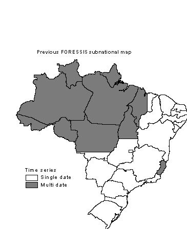
The databases available to the FRA Project for Brazil included so far State level information only, as shown in Figure 1. Considering the size of the States of Brazil, some of which are almost three times the size of France, as for Amazonas and Para, and the rapid changes in forest cover interesting these regions, the need for building up a new and detailed data set was of great relevance.
Figure 1: Sub-national units of Brazil available in FORESSIS spatial and statistical data bases
The main objective of this cooperative activity was the development of a detailed Brazilian demographic time series using recent census statistics and territorial structures. This improved data set being essential to the analysis of population/forest interaction in relation to forest cover changes observed during Forest Resources Assessment 1990 Project.
The main related activities are summarized as follows:
1. Liaison with Brazilian Institutions (IBGE, Instituto Brasileiro de Geografia Estatistica; IBAMA, Instituto Brasileiro do Meio Ambiente) and FAO Representative, Brazil, with the objective of identifying and procuring detailed Brazilian demographic data (statistical and cartographic) referred to census years 1980, 1991 and, if available, 1996.
2. Relate the areas for which land cover change processes have been observed to the demographic time series to study the population/deforestation interaction.
In order to improve the spatial resolution of forest and deforestation estimates for Brazil and better understand/predict deforestation processes, new and spatially detailed information on human population as well as on forest cover time series was needed. And the new detailed time series of population and forest needed to present a spatial and chronological correspondence.
The activities carried out to create/derive the needed data-sets involved the following steps:
Procurement of detailed spatial and statistical demographic time series
Development of forest statistics by Municipios
Population/forest data harmonization
The FORIS Deforestation Model was then applied to the new harmonized data set to estimate past (1980-1990) and projected (1990-2000) deforestation.
The search for new detailed spatial and statistical databases for Brazil and, in particular for the Brazilian Amazon, was the main objective of a field mission to Brasilia and Rio de Janeiro (see Back to Office report of this mission is Annex 2). During that mission recent demographic and the relative administrative units could be procured through IBGE Offices in Rio de Janeiro. The data set consisted of databases with 1991 administrative territorial structure, providing State, Macro-regions, Micro-regions and Municipalities, the digital map of Municipalities (Malha Municipal do Brasil), and the relative demographic data for years 1980 and 1991.
Subsequently, the results of the 1996 demographic census were also included into the data set. However, since the digital map of 1996 municipal subdivision was not available, the 1996 demographic data could be used only at State level, maintaining the 1991 structure as cartographic reference. In fact, the constant change of Brazilian territorial structure, which is due to the creation of new settlements and consolidation of existing ones, especially in or around the Amazon region, poses serious problems for the comparison of population statistics from different census years.
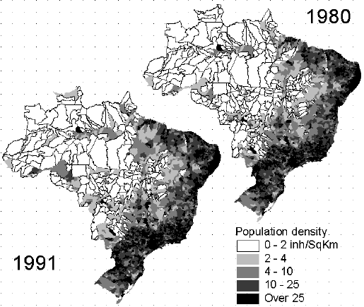
Figure 2 shows the new detailed level of demographic data procured and used for the present study. The maps show the population density at census years 1980 and 1991 by municipios. The size of municipios vary considerably from the highly populated coastal regions to the sparsely populated Amazon region. Within each state, municipios are aggregat
ed into micro-regions and then into macro-regions.
Figure 2: Population density by municipios as per census 1980 and 1991
Municipios are administrative sub-divisions for which forest statistics are not available. As mentioned before the forest information available so far consisted of statistics by state (not maps) produced on the basis of INPE data. Consequently, the development of an adequate data set of forest cover and forest change required a considerable amount of GIS work using all available statistical and spatial information. In consideration of the information available this work was limited to the Legal Amazon.
The process followed to produce the required forest state and change information by municipios included two main phases:
1. Distribution of FORIS statistics (available originally only by state) by municipios
This operation was done within the Amazonia Legal using two existing maps as "spatial proxies" to distribute the known forest area at year 1992 (from INPE) within the states.
Such maps are:
TREES forest map that reports dense forest area in the humid regions. This map was used for the wet and very moist areas, which cover most of the study area, where it is considered to represent well the forest cover.
The ICIV vegetation map of tropical regions was used for the drier eastern states of Maranhao, Tocantins and Mato Grosso for which a representation of open forest formations was necessary.
2. Spatial distribution of forest change
Forest change information for the period 1980-1990, in the form of State-level statistics, was available from FORIS database, which was based on INPE time series. In addition, an indication of the spatial distribution of forest change (necessary to distribute the FORIS change estimates within each State) was derived from published material1 that reported the area deforested within Legal Amazon, for years 1978 (INPE/FAO) and 1988 (Landsat Pathfinder), represented on 16 Km cells. This information, although indicative, was considered important in order to spatialize by municipios the deforested areas estimated by FORIS from INPE time series, originally available only at state level
The following step consisted in the creation of a consistent data set reporting, for the resulting units, information on the state and change of both human population and forest parameters.
In synthesis, the spatialized state and change information resulting from the previous phases was:
Spatial distribution of state and change of human population, derived from IBGE data set which included the distribution of the 1980 population by 1991 territorial structure.
Spatial distribution of forest cover, obtained relating INPE statistics, available for the Legal Amazon, to TREES Forest Map and to ICIV Vegetation Map, as described in the previous chapter.
Forest cover change statistics for the period 1980 - 1990, in the form of State-level statistics, was available from FORIS database, which was based on INPE time series. In addition, an indication of the spatial distribution of forest change (necessary to distribute the FORIS change estimates within each State) was derived from published material2 that reported the area deforested within Legal Amazon, for years 1978 (INPE/FAO) and 1988 (Landsat Pathfinder), represented on 16 Km cells. This information, although indicative, was considered important in order to spatialize by municipio the deforested areas estimated by FORIS and the INPE time series, originally available only at state level.
The creation of a consistent data set implied the spatial distribution of all parameters at the lowest possible level.
The most difficult part consisted in the distribution of FORIS deforestation at the level of municipios. This was often impossible, in view of the small size of municipios in densely populated areas and to the limitations of the data available (coarse spatial resolution, data missing due to cloud cover and reference only to dense evergreen forests). These limitations forced the aggregation of individual municipios at micro region (first level of aggregation) or higher level in order to develop a consistent data set.
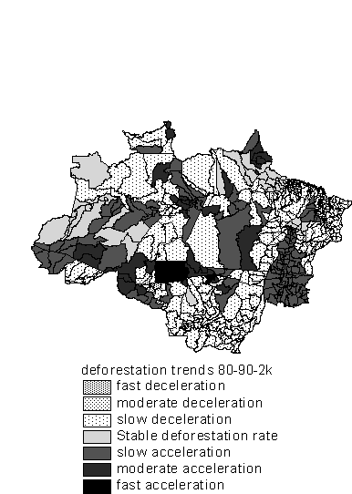
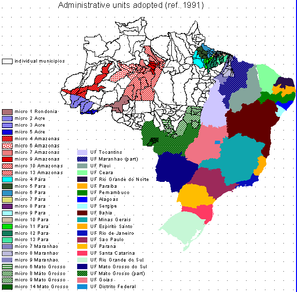
The result of this process consists of a map of Brazil, shown in Figure 3, composed by 138 units, some of which are municipios (less populated areas), some microregions (denser populated areas of Legal Amazon Region), and some States (outside Legal Amazon Region)
Figure 3: Administrative units of aggregation
The main concepts and structure of the Deforestation Model developed as part of FORIS during FRA 1990 is described in Annex 1. The Model can be represented by a differential equation as follows:
dy/dp = b1 * Y b2 - b3 * Y (1)
Where:
y is defined as percentage of non-forested area
y = ((Total area) - (Forest area))/(Total area) *100
dy/dp = derivative of y with respect to population density
b1, b2 and b3 are parameters (see details in Annex 1)
The Model in its general form can be used to estimate forest area change at pan-tropical level. However, if local observation of forest area and population change are available the model can be used to perform the so called `local fits' where the model parameters can be adapted to local conditions and the calibrated parameters used to extrapolate the forest area change over time.
The latter procedure was adopted in the present case study. Deforestation rates (dy in the change model) observed at the smallest administrative unit (Municipios, or aggregations of Municipios as shown in the previous Section), were compared with the corresponding population growth (dp in the change model) in order to estimate the local value of the b1 parameter for each unit.
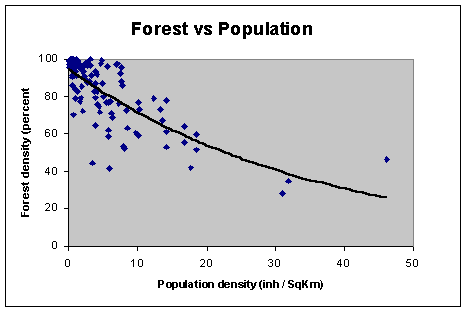
As result of the steps described in the Sections above the newly created database consists of 138 units, versus the nine units previously available for the Amazonia Legal. Figure 4 shows the scattergram of forest and population at year 1991 for the 138 units. There is a clear and strong similarity between this distribution and the model curve shown at the end of Annex 1 for the Wet Ecological Zone.
Figure 4: Scattergram of forest cover and population density for the 138 administrative units
FORIS deforestation model could therefore be run to produce a new and much more detailed spatial distribution of estimated deforestation over the period 1980 - 1990 - 2000.
Once the local value of the parameter has been computed for each of the 138 units, the corresponding forest area for different reference dates was calculated using the general model, having defined the population as a proxy for time. In synthesis the calibrated model was used to predict forest cover in a given location and for a given moment in time by supplying the corresponding population density. In the present case study the model was used to extrapolate the forest cover for the reference dates 1980, 1990 and 2000. In order to maintain a consistency with the official figures published by INPE based on the interpretation of multi-temporal Landsat TM scenes for the entire Legal Amazons (Project PRODES), the results obtained were normalized to match the official INPE figures. Therefore, the total "INPE" deforestation was distributed proportionally to each Municipio using the model results as criterion to allocate the proportion.
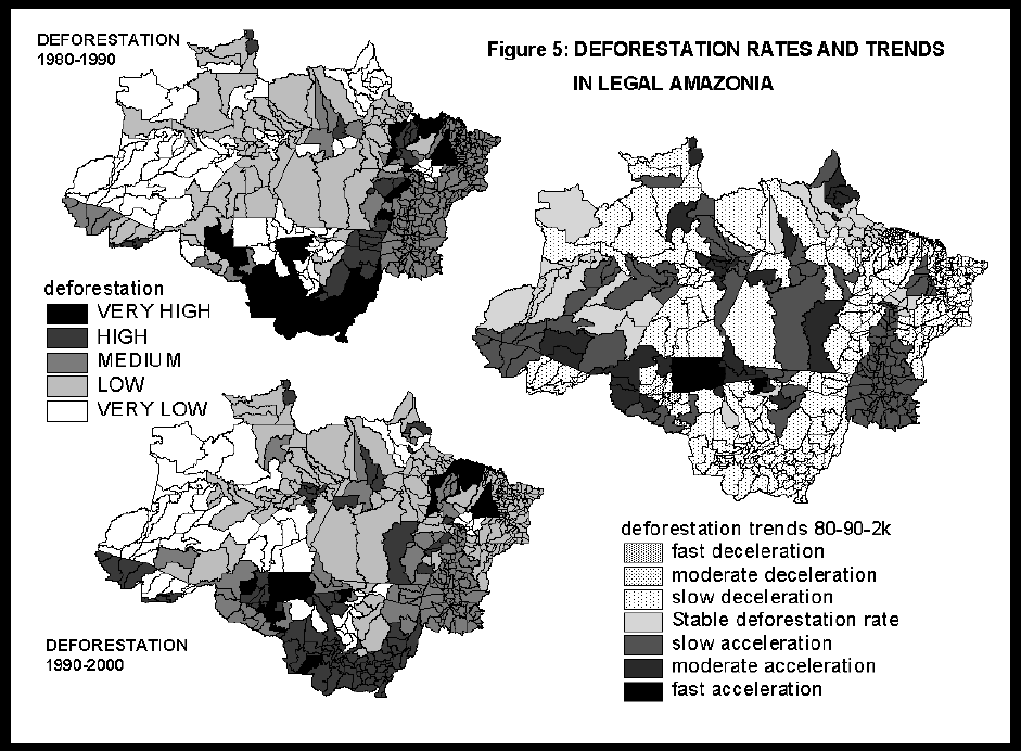
The results were forest area change time series (1980, 1990, 2000) for each of the 138 units composing the new forest/population data set. These results are displayed in Figure 5. The maps in Figure 5 report deforestation rates for the periods 1980-1990 and 1990-2000 from model application and the deforestation trends resulting from the comparison, for each sub-national unit, of the two rates. Rates and trends are displayed on the background of the original municipios but are valid only for the units of aggregation, within the Amazonia Legal, shown in Figure 3.
Besides providing a reliable tool for performing extrapolations in time, the present model approach can also give valuable information on the effect of population growth with respect to deforestation for relatively small units such as municipios, and may also lead to the refinement of the model and better adaptation to local conditions to take into account other socio-economic variables.
During FRA 1990 the tropical regions were surveyed to study pan-tropical, regional forest cover, deforestation rates and land cover change processes3. The survey was based on a statistical sample of 117 sampling units each composed by multi-date satellite images. 17 sampling units were located in Brazil, 11 of which in Legal Amazonia. As part of a cooperative activity with the Project TREES of the European Joint research Center (JRC), and in the context of the FRA 2000, a sub-set of the South America sampling units are now being revisited with recent satellite images. Seven of these units are located in Brazil, five of which in Legal Amazonia.
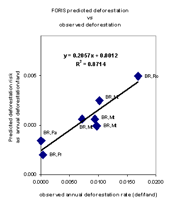
The results of the re-visit of these sampling units in Legal Amazonia can now be used to verify the efficiency of the deforestation risk stratification based on the model application described in the present paper. Figure 6 below shows the scattergram of predicted versus observed deforestation rates. The two data sets are not completely comparable since the results of the model refer to the entire area of the administrative units, which means that the estimated deforestation is evenly spread over the entire territory, while the observed deforestation refer to the area actually changing within of the satellite images employed. This in fact explain the differences between the Y axis and the X axis and the 0.2 coefficient of the trend line equation. What is very encouraging is the high coefficient of correlation (R2=0.87) which implies that the FORIS data set could be used to stratify the selection of future samples to improve the efficiency of deforestation estimates.
Figure 6: Scattergram and trend line of predicted (FORIS) versus observed deforestation from selected sampling units in Brazil
The improvement of the Brazil data set is very important since the estimated deforested area of this country alone accounts for approximately one forth of the total tropical deforestation. The previous administrative units reported in FORESSIS were far too gross for an area so sensitive to deforestation dynamics. The new data set allows for a much better spatial distribution and far more intimate population/deforestation relation. In particular, the result of the present study indicate that the pressure on the Amazon forests has a wide front that is progressively moving toward the center of the Basin.
Both FORESSIS and the remote sensing component of FRA 2000 will benefit from the improvement of the Brazil data set.
In order to enhance the understanding of the man/forest relation and our capacity to study/predict environmental changes, it is recommended to continue to produce data on the distribution of human population both in space and in time.
During Forest Resources Assessment 1990 (FRA 90) a pan-tropical deforestation model was developed in order to adjust the original forest cover observations, having different reference dates, to the standardized reporting dates, namely 1990 for FRA 90 and 1995 for SOFO 97. The model was built on a statistical basis, analyzing the correlation between the observed forest area change and ancillary variables. The results of the statistical procedure were that a significant correlation was found between forest cover and human population density and that ecological conditions play a major role in influencing the man / forest interactions.
The model was developed interpreting the man / environment interaction as a biological growth process. Very much like biological growth processes deforestation was observed to increase relatively slow at initial stages, much faster at intermediate stages, and slow down at final stages. Using this analogy forest area change can be represented by a differential equation of the form :
dy/dp = b1 * Y b2 - b3 * Y (1) Change model
In our case
y is defined as percentage of non forested area
y = ((Total area) - (Forest area))/(Total area) *100
dy/dp = derivative of y with respect to population density
b1, b2 and b3 are parameters.
Representing forest area by a density value and substituting time by corresponding population density values enables the direct comparison of countries of different size and at different growth stages. Time is indirectly considered through population growth.
An high correlation between population density and forest cover was found using a logarithmic transformation for population density. Measuring population density in persons by square kilometers P is defined as
P = logn(1 + Population density)
The Change Model structure can be briefly describes as follows:
(i) dy/dp : Dependent variable. It is the ratio between population change and forest area change. It can be represented as the response 'dy' to a given change of population pressure 'dp'. The higher the value of the ratio (dy/dp), the higher the change of forest cover per population change. dy/dp is a function of the 'size' of the forest (Y in equation (1)) and of the following parameters:
(ii) b1 : This parameter can be represented by a productivity index, or site quality to follow the analogy with yield modelling. In fact in the present model formulation it is a function of bio-climatic parameters. It is important to remark that the meaning of b1 is that the same population growth rate has different effect in different ecological conditions. If time series of forest cover and population are available, the b1 parameter can be computed from the observed value.
(iii) b2 : This parameter represents the culmination point of the derivative function. In the State Model curve (Figure ) it is the inflection point of the curve, where deforestation rate culminates and start to decrease.
(iv) b3 : This parameter is related to the maximum possible deforestation represented by the asymptotic value of Y where an increasing level of population has no effect on forest cover which remains stable in time. This parameter can be related with accessibility, both physical and legal, of the forest resources and to land suitability of forest areas for transfer to other land uses.
State Model
Integration of the differential equation (1) leads to the Chapman-Richards function of the form:
y = a0 * (1- a1 * e (-a2 * P)) a3 (2) State model
The cumulative growth curve defined by this equation has a sigmoid shape and an upper asymptote; a0, a1, a2, and a3 are the four parameters (see Figure 2). The function gives the estimated forest area for a given population density level.
The following system of equations defines the model parameters:
(1) a0 = ym
(2) a1 = 1 - (y0 / ym) (1 - b2)
General model
(3) a2 = (1 - b2) * b1 * ym (b2 - 1)
(4) a3 = 1 / (1 - b2)
where ym = maximum possible non-forested area
y0 = non-forested area for P = 0
b1 and b2 are parameters of the change model
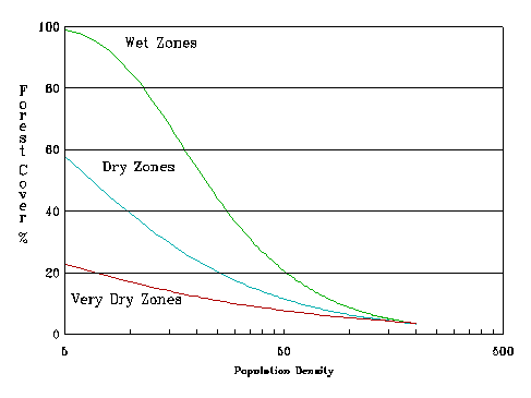
It can be noticed that an additional variable y0 is needed to solve the State model equation (2). y0 represents the 'initial conditions' of the site, in terms of forest cover for population density=0. The effect of different initial ecological conditions is illustrated in the next figure.
Illustration of model curves for different ecological zones
ANNEX 2
BACK TO OFFICE REPORT
Rudi Drigo
Forest Monitoring Officer
Duty travel to Brazil 14 - 23 December 1996
in connection with
SDWP Activity "Population in Deforestation Assessment", and
planning of Remote Sensing Component of FAO Forest Resources Assessment 2000
Objectives of the mission
1. Procure, and organize collection of, demographic data and infrastructure development time series, through IBGE, IPEA, IBAMA, with the objective of developing a detailed statistical/spatial data set to be used for deforestation modelling in the framework of the SDWP Activity "Population in Deforestation Assessment" and planning/design of FRA 2000 activities.
2. Reinforce cooperative contacts with:
2.1. IBAMA for the interpretation/verification of FRA 2000 Remote Sensing Sampling Units (including revisit of FRA 1990 SU's and analysis of new FRA 2000 SU's)
2.2. INPE for the collection of existing information concerning Brazil's forest resources, in the framework of FRA 2000 FORIS component
Travel schedule:
| date | Location | Travel | Activities |
| 14 Dec | Rome | dep. 23.20 az672 | |
| 15 Dec | Rio de Janeiro | arr. 07.55 | |
| 16 Dec | Rio de Janeiro | 9.00 IBGE, Directoria de Geociencias; 14.00 IBGE, Dep. de Recursos Naturais e Estudos Ambientais 17.00 visit Dr. Reis (Instituto de Pesquisa Economica Aplicada) |
|
| 17 Dec | Rio - Brasilia | dep. Rio 08.15 vp282 arr. Brasilia 09.55 |
10.00 FAOR ; 14.00 IBAMA; 16.30 MRE/DEMA (Ministry of External Relations) |
| 18 Dec | Brasilia | 8.30 IBAMA 16.00 MMA (Ministerio do Meio Ambiente |
|
| 19 Dec | Brasilia - Sao Jose dos Campos | dep. Brasilia 18.00 tr305 arr. S.Paulo 19.30 (by car to SJdC) |
IBAMA FAOR travel to Sao J.dos Campos |
| 20 Dec | Sao J.dos Campos | 10.00 INPE | |
| 21 Dec | S.J.d.Campos -Rio | travel to Rio de Janeiro | |
| 22 Dec | Rio de Janeiro | ||
| 23 Dec | Rio - Rome | dep. Rio 16.25 az673 | 11.00 IBGE, Directoria de Geociencias; |
| 24 Dec | Rome | arr. Rome 06.00 |
Activities related to Objective 1:
Visit IBGE (Instituto Brasileiro de Geografia Estatistica) with the purpose of acquiring and ascertaining the availability of consistent demographic (census data at municipios and micro/meso regions) and infrastructure development (road/railways network) time series, covering the period 1970 to date.
During the meeting with IBGE Officials of the Diretoria de Geociencias, namely Ms. Isabela de Fatima Texera Silva, Dept. de Cartografia, and Mr. Paulo Cesar Martins, Dept de Estrutura Territorial, the reporting officer explained the Project's need for a detailed and multi-temporal demographic database (spatial and statistical) of Brazil.
Results of 1991 Census are available in digital form spatially and statistically.
The real problem is the relation with earlier census (1980, 1970), since the territorial structure (municipios) kept changing all the time.
Ms Silva informed that his Department is currently recovering the earlier territorial structures into GIS and that this activity will probably last one more year. Ms Silva offered a copy of the CD "Malha Municipal do Brasil 1991-1994" with current territorial structure.
Mr. Martins offered a database file listing the 1991 municipios that were created after 1980 and the municipios from which they were derived.
Ms Silva and Mr. Martins suggested to contact Dr. Lenildo Fernandes Silva, Director of Diretoria de Pesquisas, IBGE, with the request of 1980 census results by municipios, which are not readily available at IBGE Libraries.
Regarding infrastructure development, IBGE does not have maps in digital or paper showing road, railways networks time series. Topographic maps are currently being digitized but the work is huge and will require at least two years.
On the last day of the mission the reporting officer passed by the offices of Ms Silva and Mr. Martins and received the promised CD "Malha Municipal do Brasil 1991-1994" and the databases relating municipal structures 1980-1991. Since during the mission all IBGE libraries of Brazil were closed for end-year accounting, the friendly generosity of IBGE Officials have been extremely precious.
Meeting with IBGE Officials of DERNA (Departamento de Recursos Naturais). The purpose of this meeting was to ascertain the availability of information on forest cover and deforestation estimates outside Legal Amazonia.
The results of the discussion with Dr. Jose Enilcio Rocha Collares, Department Chief, and Dr. Antonia Maria Martins Ferreira, are that there is no new information at state level outside Legal Amazonia.
DERNA Officials showed the rich GIS data set (INTERGRAPH) being assembled for Legal Amazonia that includes 1976 RADAMBRASIL data and recent (~1990) interpretation of Landsat data. They applied a detailed vegetation/forest type classification which makes it suitable for studies of biomass and ecosystem/biodiversity change.
The data set is not available but could become so if an agreement for scientific cooperation is formally requested and agreed upon. DERNA would be interested to develop a statistical sample survey approach and develop models on forest change in Legal Amazonia.
Although IBGE is involved in numerous sporadic and local studies outside Legal Amazonia, these seem to remain at low priority.
Meeting with Dr. E. J. Reis of IPEA (Instituto de Pesquisa Economica Aplicada)
The purpose of the meeting was to familiarize with Dr. Reis' studies on population/deforestation interaction in Brazil, and identify possible cooperative activities and share of information.
Dr. Reis produced an harmonized 1970-1980-1991 administrative unit data set (compatible common aggregations of municipios) for the Amazonia Legal. He built up a rich data set that includes also 1976-1986 road network time series, at scale ~1:5 Million, produced by DNER-MT (Department of Roads of the former Ministry of Transportation).
A copy of Dr. Reis' paper "DESMAT - Municipal Database on Demography, Economy, and Ecology of Brazilian Amazonia", which describe the database, is with the reporting officer.
The database is only statistical, i.e. numeric parameters by administrative units. The GIS work behind the database was, on Dr. Rais words, very basic and at very small scale, and parameter allocation hat to be, at times, result of subjective guesses.
The database is not available. Dr. Reis could agree to share part of his data if he can get something consistent in exchange. The results of his studies (not his database) were also not readily available.
We agreed that we would send him FRA papers and he would send us his papers with the conclusions of his studies. If he will find something of interest among our data sets he might make part of his data set available to FAO.
Dr. Rais work seems interesting but its coarse resolution and its confinement to the Legal Amazonia makes it useful but not vital for FAO purposes.
Activities related to Objective 2
In relation to Objective 2 i.e. reinforce cooperative relations with Brazilian institutions in the framework of FRA 2000 activities, the reporting officer had separate meetings with the following institutions:
Ministry of External Relations (MRE), Brasilia;
Instituto Brasileiro do Meio Ambiente (IBAMA), Brasilia;
Ministry of Environment (MMA), Brasilia;
Instituto de Pesquisa Espaciais (INPE), Sao Jose dos Campos.
While the meetings with IBAMA and INPE have been requested by the reporting officer, the two with Ministerial Officers have been requested by FAOR Office with the intention to clarify technical and methodological elements on which FAO forest and deforestation estimates for Brazil were produced in the past, and describe FRA2000 approach. This clarification was considered very important since it appeared that, due to some misunderstanding of FAO estimation methods, the relations between FAOR and Brazilian Ministries were somehow difficult.
Meeting at Ministry of External Relations (MRE), Brasilia
During the meeting with Conselheiro E. Cordero the reporting officer could clarify past and present FAO estimation methodologies and hand over copies of all relevant FRA 1990 documents and the explanatory note prepared by Walter Marzoli documenting Brazilian estimates to be published in SOFO 97. Since the main criticism appeared to be "the arbitrary estimation by FAO of Brazilian deforestation based on limited sampling approach", obvious result of a basic misconception of FAO methods, Mr. Cordero was very happy to receive clear documentation on how FAO used data from Brazilian Institutions to produce national estimates and that the remote sensing survey was not used to produce national statistics but only to describe consistently land cover change processes at regional and ecological level.
Mr. Cordero commented that such technical documentation should be distributed widely to avoid misconceptions and unjustified criticism.
Meeting at Instituto Brasileiro do Meio Ambiente (IBAMA), Brasilia
Meeting attended by Adalberto da Costa Meira Filho of DIRPED (Diretoria de Incentivo a' Pesquisa e a Divulgacao), on behalf of Dr. Jose Dias Neto, Director, Flavio Simas de Andrade of CSR (Centro de Sensoriamento Remoto), Cirineo Jorge Lorensi of DIREN/DIFLONA.
After a brief presentation by the reporting officer of FRA 2000 scope and methodologies, the meeting with IBAMA Officials mainly concentrated on its participation to FRA 2000 and on the procedure to be followed to make such participation formal and official.
In view of the wide range of potential fields of assistance and cooperation, it was pointed out that project proposals will be originated by the party directly interested or responsible for the specific activities. FAO will therefore come foreword with proposals related to FRA 2000 and IBAMA will do it for activities related to Brazil for which FAO assistance is sought, if any.
On a general statement of interest to cooperate to FRA 2000 remote sensing survey, it was agreed that FAO will prepare a proposed Letter Of Agreement as soon as the FRA 2000 enters the implementation phase.
This cooperation will include the analysis of some 50 additional sampling units (yet to be selected) in the framework of FRA 2000 survey.
In consideration of the powerful GIS capacities that IBAMA has recently developed, that were proudly showed to the reporting officer, it is advisable to include in the proposed LOA all GIS activities related to FRA 2000 in South America region.
Meeting at Ministry of Environment (MMA), Brasilia
Meeting attended by Dr Francisca Menezes, Dr Antonio Carlos do Prado, Diretor de Est. Desenv. Sustentaivel, Luiz Antonio Fachini Gomes, Assessor Especial para Assuntos Internacionais, Luiz Carlos Ros Filho, Coordenador Geral, Secretaria de Formulacao de Politicas Ambientais, Ms Eliana Martins, FAOR.
During this meeting the reporting officer presented FAO estimation procedures, i.e. FORIS database development from national data sources and the remote sensing survey, its principles and results, and discussed the overall plans for FRA 2000 activities and the relation with Brazilian Institutions.
It is hoped that these clarifications will favor the future formal and institutional relations between FAO and Brazil related to global and national forest resources assessments.
Meeting at Instituto de Pesquisa Espaciais (INPE), Sao Jose dos Campos
During the meeting with Dr. Thelma Krug , Coordenador Geral de Observacao da Terra,
INPE contribution to FRA 2000 FORIS statistics for Legal Amazonia and remaining parts of Brazil was discussed. From this meeting it resulted that:
INPE is handing over its information set covering Legal Amazonia to IBAMA who will be in future the reference institution for these statistics.
INPE is currently digitizing the interpretations of Legal Amazonia as a unique layer as a summary of interpreted deforestation (not keeping separate deforestation interpreted in 1988, 1990, 1992, etc.). This data set that will be ready sometime in the future could be requested to Dr. Barbosa.
The results of the Mata Atlantica Study (state and change (?) of the coastal natural forest) will be available in about 3/4 months. A CD ROM with the resulting maps will probably be produced.
Conclusions and follow up actions related to Objective 1
The spatial and statistical data collected during the mission is sufficient to initiate the GIS work needed to produce consistent spatial time series of population in brazil covering the period 1980-1991. This work will be carried out in Rome in early 1997.
The additional information needed to complete the work is the following:
| data to be procured | Proposed actions, contacts |
| Total population by municipios as per 1991 census; data should be in IBM compatible diskette | This data set is available from IBGE Libraries (SIEG/91). To be procured through FAOR |
| Total population by municipios as per 1980 census; municipios must contain 1980 IBGE code and micro, meso region codes; data should be in IBM compatible diskette |
This data set is not commercially available. FAOR Brazil is kindly requested to send request for the data to IBGE, Rio de Janeiro; Fax 284 1109 IBGE will reply specifying costs and payments. Contact person Mr. Carlos Lessa Tel 569 2043 ramal 285 or 112 |
| New demographic estimates from the 1996 census. | This information should become available in the early months
of 1997 (IBGE). To be procured through FAOR as above. |
| Road, rail network development | This data set was produced as map by Department of Roads of
former Ministry of Transportation for the years 1976 and 1986. Availability and present source yet to be identified. |
| GDP (Gross Domestic Product) by state from 1970 to date. | IGBP must have this information for 1970, 1975, 1980, 1985
(and hopefully more recent years) FAOR is kindly requested to send request for this data set to IBGE |
| Sharing of information with Dr. Reis, IPEA | The reporting officer will send a complete set of FRA documents to Dr. Reis and request documentation of his studies and databases. |
Conclusions and follow up actions related to Objective 2
In view of the strong political value of the "deforestation issue" in Brazil, and in view of the widespread misconception of FAO assessment scopes and approaches, it is essential that FRA methods and procedures achieve higher visibility and widespread distribution in Brazil.
FAOR Brazil must be well informed and documented in order to be able to remove politically dangerous doubts and misconcepts and clarify FAO scientific assessment attitude.
It appears from the meetings and discussions held during the mission that IBAMA is strengthening its role as institution of reference for forest resource estimates for Brazil. IBAMA is receiving INPE data sets over Legal Amazonia and progressively improving its geographic precision through GIS work with the purpose of using the information to support local planning and action.
IBAMA should therefore be considered as the direct reference for FORIS as well as Remote Sensing survey in FRA 2000.
A proposed Letter Of Agreement between FAO and IBAMA should be prepared by FAO and sent to FAOR Brazil as soon as the FRA 2000 will reach the implementation phase.
Persons met:
| IBGE (Instituto Brasileiro de Geografia Estatistica) | |
| IBGE - Diretoria de Geociencias | |
| Av. Brasil, n. 15671 Parada de Lucas CEP 21241 - 051 Rio de Janeiro | Tel (021) 391 1980 Fax (021) 481 1076 |
| Dra. Isabel de Fatima Texeira Silva | |
| Chefe do Departamento de Cartografia | Tel (021) 391 1420 R/232 E-mail [email protected] |
| Ms. Anna Lucia Barreto de Freitas | |
| Departamento de Cartografia | Tel (021) 391 1420 R: 235/217 E-mail [email protected] |
| Dr. Paulo Cesar Martins | |
| Chefe Departamento de Estrutura Territorial | Tel (021) 391 4797 |
| IBGE - Departamento de Recursos Naturais e Estudos Ambientais DERNA | |
| Av. Chile, 500 - Centro CEP: 20031-170 Rio de Janeiro -RJ | |
| Dr Jose Enilcio Rocha Collares | |
| Chefe do DERNA | Tel: (021) 262 6262 R: 4581 Fax: (021) 240 6064E-mail [email protected] |
| Dra. Antonia Maria Martins Ferreira | |
| UERJ, Fac. de Geologia / IBGE | Tel: (021) 587 7102 Fax (021) 254 6675E-mail [email protected] |
| Instituto de Pesquisa Economica Aplicada IPEA | |
| Av. Antonio Carlos 51 s/1704 Rio de Janeiro, RJ 20.020-010 | Tel (021) 2121178 / 1180 / 1121 Fax (021) 2401920 |
| Dr. Eustachio J. Reis | E-mail: [email protected] |
| IBAMA - Instituto Brasileiro do Meio Ambiente | |
| Brasilia | |
| Dr. Jose Dias Neto | |
| Diretor, DIRPED (Diretoria de Incentivo a' Pesquisa e a Divulgacao) | Tel: (061) 223 7879/316-1185 Fax: (061) 226 5588 |
| Adalberto da Costa Meira Filho | |
| DIRPED (Diretoria de Incentivo a' Pesquisa e a Divulgacao) | Tel: (061) 223 0014 Fax: (061) 226 5588 |
| Flavio Simas de Andrade | |
| Centro de Sensoriamento Remoto CSR | Tel: (061) 316 1326 / 1218 Fax: (061) 223 7108 E-mail [email protected] |
| Cirineo Jorge Lorensi | |
| DIREN/DIFLONA | Tel: (061) 316 1260 Fax: (061) 223 6350 |
| Ms Debora Campos Jansen | |
| Centro de Sensoriamiento Remoto | Tel: 243 4933 |
| Ministerio de Relacioes Exteriores - MRE | |
| Dr Enio Cordeiro | |
| Conselheiro MRE / DEMA Esplanada dos Ministeiros, Bloco H, Anexo I / Sala 635 |
Tel: (061) 211 6873 |
| Ministerio do Meio Ambiente - MMA | |
| Esplanada dos Ministeiros, Bloco B Sala 512 |
|
| Dra Francisca Menezes | Tel: (061) 317 1237 |
| Dr Antonio Carlos do Prado | |
| Diretor de Est. Desenv. Sustentaivel | Tel: (061) 317 1175 |
| Luiz Antonio Fachini Gomes | |
| Assessor Especial para Assuntos Internacionais | Tel: (061) 317 1241 - 322 7819 Fax: (061) 226 7101 |
| Luiz Carlos Ros Filho | |
| Coordenador Geral, Secretaria de Formulacao de Politicas Ambientais | Tel: (061) 317 1163 Fax: (061) 323 7936 E-mail [email protected] |
| Instituto Nacional de Pesquisas Espaciais - INPE | |
| Av. Astronautas, 1758 - 12227-010 Sao Jose dos Campos - SP |
|
| Dra. Thelma Krug | |
| Coordenador Geral de Observacao da Terra | Tel: (012) 325 6450 - 341 1868 Fax:(012) 325 6460 E-mail [email protected] |
1 "Tropical Deforestation and Habitat Fragmentation in the Amazon: Satellite Data from q978 and 1988"; D. Skole and C. Tucker; Science, June 1993, Vol 260.
2 "Tropical Deforestation and Habitat Fragmentation in the Amazon: Satellite Data from q978 and 1988"; D. Skole and C. Tucker; Science, June 1993, Vol 260.
3 Its features and results are described in detail in the document "Forest Resources Assessment 1990 - Survey of Tropical Forest Cover and Study of Change Processes", FAO Forestry Paper 130, 1996.
