Новости
В настоящем разделе публикуются статьи и новости о деятельности ФАО, связанной с применением геопространственных технологий и методик.

Food and Agriculture Organization of the United Nations (FAO) and International Organization for Standardization/ Technical Committee-211 (ISO/TC211) organized the seventh Advisory Group-13 (AG13) on Land Cover and Land Use meeting on 16 May 2023 to raise awareness of the importance...
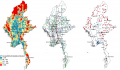
FAO recently conducted a methodology validation workshop for the project "Strengthening Agricultural Value Chain through Geospatial Value Chain Analysis." The project aims to assess the national-scale geospatial and temporal agricultural value chain in Myanmar, identifying priority chains for targeted interventions....

In the Central African Republic, the Ministry of Agriculture, in collaboration with the World Bank, successfully concluded the first computerized spatial data management course for the "Emergency Response Project to the Food Crisis" (PRUCAC). The training, held at FAO headquarters...

The Geospatial Unit of the Food and Agriculture Organization of the United Nations (FAO) and the Arab Organization for Agricultural Development (AOAD) organized a virtual technical workshop from 14 to 16 March 2023 on the use of remote sensing and...
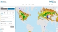
The Food and Agriculture Organization of the United Nations (FAO) and the International Renewable Energy Agency (IRENA) have collaborated to make available priority geospatial layers of agro-ecological zoning from the Global Agro-Ecological Zoning version 4 (GAEZ v4) on the...