Proyectos
Aquí se ofrecen ejemplos de proyectos - pasados y en marcha - de seguimiento agrícola y evaluación de la cobertura del suelo, preparados por la FAO utilizando métodos e instrumentos geoespaciales.
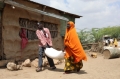
The proposed intervention by the FAO (OSRO/SOM/211/USA) aims to enhance food security for drought-affected populations in rural Somalia. They plan to extend their humanitarian assistance to 31 districts categorized as drought hotspots. This project will benefit 49,250 households (approximately 295,500...
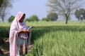
In response to the priorities of the Government of Balochistan has formulated the “Revival of Balochistan Water Resources Programme (RBWRP) (GCP/PAK/159/EC)”. Currently Balochistan is facing multiple issues and challenges with the management of its natural resources, especially water and rangelands,...
01 January 2022
The humanitarian situation in Somalia is highly fragile, with nearly 3.5 million people expected to face severe food consumption gaps, indicating a Crisis (IPC 3) or worse, by the end of 2022. Key drivers of acute food insecurity include poor...
01 November 2021
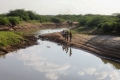
The agricultural sector in Libya faces various challenges, with difficult environmental conditions mostly dominated by limited access to water resources (only four percent of Libya lies outside the desert and arid agro-ecological zone and approximately seven percent of the country...
02 April 2021
Libya is characterized by an absolute water scarcity with its annual per capita internal renewable water resources around 106 m3/capita/yr. The project monitoring, evaluation and rationalization of water use for the agriculture sector in Libya (OSRO/LIB/002/ITA) aims...