Publications
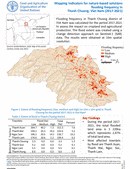
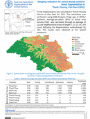
Mapping Indicators for nature-based solutions flooding frequency in Thanh Chuong, Vietnam (2017-2021)
10 October 2022
10 October 2022
Flooding frequency in Thanh Chuong district of Viet Nam was calculated for the period 2017-2021to assess the impact on cropland and agricultural production. The flood extent was created using achange detection approach on Sentinel-1 (SAR)...
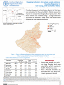
Mapping indicators for nature-based solutions flooding frequency in Con Cuong, Vietnam (2017-2021)
10 October 2022
10 October 2022
Flooding frequency in Con Cuong district of Viet Namwas calculated for the period 2017-2021 to assess theimpact on cropland and agricultural production. Theflood extent was created using a change detectionapproach on Sentinel-1 (SAR) data. The...
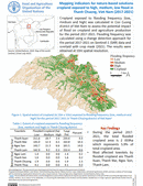
Mapping indicators for nature-based solutions cropland exposed to high, medium, low flood in Thanh Chuong, Vietnam (2017-2021)
10 October 2022
10 October 2022
Cropland exposed to flooding frequency (low, medium and high) was calculated in Con Cuongdistrict of Viet Nam to assess the potential impact of flood on cropland and agriculture productionfor the period 2017-2021. Flooding frequency wascalculated...
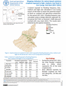
Mapping indicators for nature-based solutions cropland exposed to high, medium, low flood in Con Cuong, Vietnam (2017-2021)
10 October 2022
10 October 2022
Cropland exposed to flooding frequency (low, medium and high) was calculated in Con Cuongdistrict of Viet Nam to assess the potential impact of flood on cropland and agriculture productionfor the period 2017-2021. Flooding frequency wascalculated...
Mapping indicators for nature-based solutions forest fragmentation in Thanh Chuong, Vietnam (2021)
10 October 2022
10 October 2022
Forest fragmentation was calculated in Thanh Chuongdistrict of Viet Nam for 2021. The calculation wasperformed using GWB Analysis (Frag) app of SEPAL1platform. Average-per-patch (APP) of forest areadensity (FAD) was calculated through an average ofsquare neighborhood...