Publications
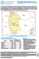
An assessment of land degradation was carried out following the UNCCD’s Good Practice Guidance (GPG) version 2 for the SDG Indicator 15.3.1 (Proportion of land that is degraded over total land area) for West Kordofan...
Land degradation during 2016 to 2022 in the localities of South Kordofan state, Sudan
16 October 2023
16 October 2023
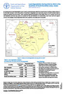
An assessment of land degradation was carried out following the UNCCD’s Good Practice Guidance (GPG) version 2 for the SDG Indicator 15.3.1 (Proportion of land that is degraded over total land area) for South Kordofan...
Libyan Land Cover Reference System
12 October 2023
12 October 2023
Land use is an essential component for many areas, from water management to agriculture, from the fight against desertification to that against climate change. The detection of changes in land cover allows a better understanding...
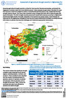
Assessing agricultural drought severity is critical for food security. Remote sensing data, particularly the Vegetation Condition Index (VCI) from MODIS product, helps evaluate drought extent. Monthly VCI maps from January to April are...
International standards for land cover: From concepts to practices
21 September 2023
21 September 2023
Standards provide a common language and framework for data collection, analysis, and reporting. The adoption of common standards for land use and land cover monitoring is essential for achieving the Sustainable Development Goals (SDGs). It...