Publications
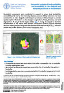
Geospatial assessments in Cabo Delgado and Nampula provinces, Mozambique, support land availability, accessibility, and use for IDPs, returnees, and host communities. A Google Earth Engine (GEE) App is being created for dynamic visualization, aiding informed...
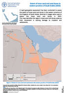
A rapid geospatial assessment has been conducted to assess the extent of loose sand and dunes in the eastern province of the Kingdom of Saudi Arabia. Sentinel–2 images were used to detect the loose sand...

The agroecological zones (AEZ) methodology, developed by the Food and Agriculture Organization of the United Nations (FAO) and the International Institute for Applied Systems Analysis (IIASA), is a well-established modelling system for land evaluation to...
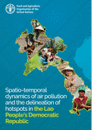
Spatio-temporal dynamics of air pollution and the delineation of hotspots in the Lao People's Democratic Republic
20 March 2023
20 March 2023
In this report, the air pollution dynamics of the Lao People’s Democratic Republic are investigated given its increasing industrial and economic development, and the employment of frequent biomass burning as an agricultural practice. The Lao...

Land cover data is fundamental to food security. Land cover information is required to monitor food security indicators, and provide information on access to water, cropping intensities and many others. Land cover for eastern Terai...