Land Cover Toolbox
Land cover mapping is a complex and multistage data processing and analysis system. It requires a set of tools from defining legend to assess the accuracy.
FAO has a set of software tools for supporting
- legend generation
- data processing
- interpretation
- statistical analyses.

The software package includes:
Land Characterization System Software (LChS)
This is an online tool that enables the guided classification of land cover features enforcing the LCML standard. This tool contains all the functionality of the LCCS with the addition of online functionality such as the integration of the FAO Land Cover Registry.
Land Cover Classification System tool (LCCS)
A user-friendly tool with a graphical user interface that allows the classification of the land cover features in a comprehensive system, applying the LCML standard. This enables the comparison and correlation of land cover classes regardless of mapping scale, land cover type, data collection method or geographical location.
An example implementation of the standard is portrayed in the following figures.
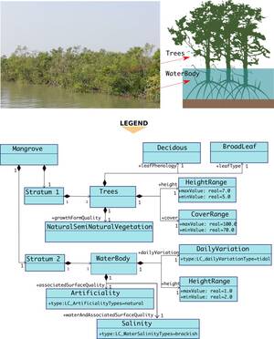
Figure 1: Elements of a mangrove land cover are described using the LCML component.
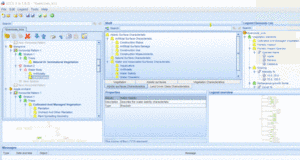
Figure 2: The legend is prepared using the LCCS tool.
Mapping Device-Change Analysis Tool (MAD-CAT)
A stand-alone application that offers users different interpretation techniques (visual, semi-automatic, fully automatic) as well as tools for working with vector layers (editing tool) and raster layers (i.e. arithmetic operations, calculation of vegetation indices within polygons).
System for earth observation, data access, processing, analysis for land monitoring (SEPAL)
SEPAL is a cloud computing-based platform for autonomous land monitoring using remotely sensed data. It is a combination of many open-source geospatial tools and libraries that are needed for land monitoring including modern geospatial data infrastructures like Google Earth Engine. It allows users to access and process satellite data quickly and efficiently for sophisticated data processing and analyses.
Advanced Database Gateway v.3 (ADG)
A cross-cutting interrogation software that provides a user-friendly interface to analyse LCCS-based land cover data. The ADG has two main functions:
- decoding and analysis of database categories according to the LCML rules;
- customized querying by objects using the capability of the software to automatically understand the class content.
It allows end users to interrogate the database more effectively according to their specific needs and to better understand and interact with land cover databases built using the LCML (LCCS3) logic. This ensures that there is no data redundancy, no conflict of definitions, transparency and deep understanding of the classification criteria and reusability.