‘Eye in the sky’ technology helping agriculture
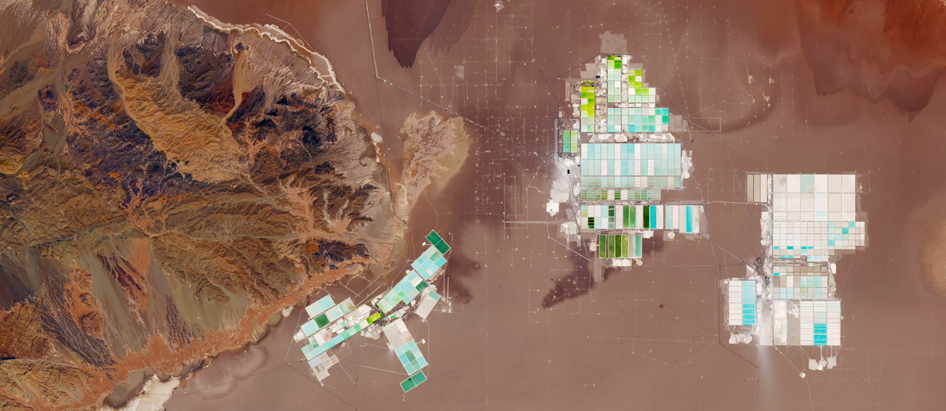
 Evaporation pond in the Atacama desert, Chile
More than 4,000 satellites currently circle the Earth, capturing an enormous amount of data that can benefit agriculture – everything from crop yield forecasts and soil organic matter to surface water.
The highest resolution satellites can even pick up ground images from about .41 meters (16 inches).
Panelists at FAO’s 2018 Investment Days, an annual knowledge-sharing event, introduced some of these cutting edge ‘eye-in-the-sky’ technologies, and shared ways in which countries and farmers are using such technologies to make better decisions.
Earth observation technology
One earth observation technology is Copernicus.
The programme, run jointly by the European Commission and the European Space Agency (ESA), aims to provide accurate and easily accessible information on the environment.
More than 25 satellites deliver a range of information services to help manage the environment, mitigate the impact of climate change and ensure civil security.
With satellite imagery covering the Earth every five days and able to distinguish between different crops, monitor plant growth, identify flood-prone areas, Copernicus is particularly “relevant for organizations like FAO,” said Stephen Coulson, Head of Industry Sector, Directorate of Programs at ESA.
The programme is working with various international financing institutions, including the World Bank, the European Investment Bank and the International Fund for Agricultural Development.
“We want to migrate this technology into development aid as a best practice source of environmental information and in support of environmental safeguard systems, M&E methodologies, sustainable development goal reporting, capacity building, and knowledge and skills transfer to developing countries,” Coulson said.
Earth Map
Another interesting innovation is Earth Map, an easy-to-use tool developed by FAO and Google to access and analyse geospatial data.
Danilo Mollicone, an FAO Forestry Officer, demonstrated the tool’s top-down menu approach, using the Kyrgyz Republic as an example to show the different options for country analysis.
Climate change is negatively affecting pasture health and soil erosion rates in the Kyrgyz Republic. The country, having submitted a proposal to the Green Climate Fund, needed to do a climate risk mapping and vulnerability analysis.
The Government requested the assistance of the FAO Investment Centre in producing empirical data.
Using Earth Map, they were able to check on annual precipitation anomalies, for example, and immediately see where precipitation had been increasing and decreasing. They could track trends in vegetation changes, assess land productivity dynamics and pinpoint trouble spots and districts.
Earth Map is unique in that it provides unprecedented access in visualizing and interacting with earth observation datasets. It overcomes limitations of Big Data for use in real-time monitoring and for historical analysis.
And it is free, and simple to download and share results, Mollicone said.
“We hope millions of people will be using it, including farmers,” he added.
Crop insurance
Extreme weather events related to climate change are happening with greater frequency and intensity, disrupting food production. Small-scale farmers are often left to shoulder the burden alone.
Pramod Aggarwal, regional program director of CGIAR’s Research Program on Climate Change, Agriculture and Food Security, introduced India’s crop insurance scheme that protects against every type of weather risk, covering about 51 million hectares of crop land and insuring 50 million farmers.
He also suggested a new weather index-based insurance scheme that harnesses Big Data and advanced analytics for greater efficiency and efficacy.
Transparent and objective premiums, loss assessments in real-time and faster claim settlements for farmers are among the scheme’s benefits.
The scheme reduces basis risk, helping to build the resilience of farmers to climate change, but “if you want more comprehensive risk management, you need to integrate many of the risk strategies, as insurance is just one solution,” Aggarwal said.
WINnERS
WINnERS is another project focused on weather index-based risk services to build resilient agricultural supply chains.
The project, supported by ClimateKIC with co-financing from the World Bank, brings together world leading expertise from climate science, meteorology, financial engineering, crop modelling, machine learning and development economics.
It uses state-of-the-art technology to predict the likelihood of extreme weather events, invests in smallholder farmers to improve their practices, and shares risk across the supply chain. The project also promotes supportive regulatory environments for insurance products in developing countries.
“Climate change challenges represent new business and research opportunities, and these challenges exist across commodities. That’s all the more reason Big Data solutions make sense,” said Dr Zen Makuch, Director, Centre for Environment Policy and Reader in Law, Imperial College, London, and part of the WINnER team.
The insurance scheme uses a blended finance approach, does not rely on subsidies and places 60 percent of the risk on banks, with insurance covering 40 percent of crop loss triggered by weather variables.
New investments will focus on improving farm-level agricultural and financial management.
“We’ll connect this to our blended finance model in a way that trains banks and insurers to lower insurance rates based on climate smart farm practices,” Makuch added.
As new technologies continue to crop up, the key for organizations like FAO is to understand how these innovations can best serve smallholder farmers around the world and ensure a more sustainable future for all.
