


This section is divided in two sub-sections, the first dealing with the extent of forest resources and the second dealing with the contribution of forests to the Global Carbon Cycle.
This subsection provides information on the method and approach chosen to identify and asses the complementary national variables and then the national data and its assessment.
The for identification and assessment of variables, India through FSI used the Group Convergence Method (Govil, 2002). Two workshops were organized one for briefing and explaining and second for implementation of Group Convergence Method to arrive the finalist of identified variables. Temporal trends were developed and GCM was used to assess the state and change in these variables with respect to sustainability of forest resources.
Following national variables in addition to the global variable Forest Cover have been identified as complementary variables that are essential to explain the state of Extent of Forest Resources in India and for which some information was available.
a. Area of Recorded Forest
b. Proportion of Dense to Open Forest Cover
c. Area of Forest diverted for Non-Forest Purposes
d. Extent of Trees Outside Forests (TOF)
e. Area of Forest under Management Plans
Following table indicates sources of data for the additional variables.
Additional Variable |
Information Year |
Source |
Recorded Forest Area |
1990 |
SFR, 1993 State of Forest Resources 1993. Forest Survey of India, Ministry of Environment and Forests, Government of India. |
1992 |
SFR, 1995. State of Forest Resources 1995. Forest Survey of India, Ministry of Environment and Forests, Government of India. | |
1994 |
SFR, 1997. State of Forest Resources, 1997. Forest Survey of India, Ministry of Environment and Forests, Government of India. | |
1997 |
SFR, 1999. State of Forest Resources, 1999. Forest Survey of India, Ministry of Environment and Forests, Government of India. | |
2000 |
SFR, 2001. State of Forest Resources, 2001. Forest Survey of India, Ministry of Environment and Forests, Government of India. | |
Diversion of Recorded Forest Area |
1990 |
Forestry Statistics, 2000. Indian Council Of Forestry Research and Education. Dehradun, India |
1998 |
Forestry Statistics, 2000. Indian Council Of Forestry Research and Education. Dehradun, India | |
Open and Dense Forest Cover |
1990 |
SFR, 1993 State of Forest Resources 1993. Forest Survey of India, Ministry of Environment and Forests, Government of India. |
2000 |
SFR, 2001. State of Forest Resources, 2001. Forest Survey of India, Ministry of Environment and Forests, Government of India. | |
Trees Outside Forests |
1990 |
Pilot Study Forest Survey of India, 2003 |
2000 |
Pilot Study Forest Survey of India, 2003 | |
Forest under Management Plans |
1987 |
SFR, 1987, State of Forest Resources 1987. Forest Survey of India, Ministry of Environment and Forests, Government of India. |
2000 |
Ministry of Environment and Forest, Government of India cited in Pilot study by FSI |
This section provides information on each of the identified additional variables. It contains relevant definitions, source and source data, temporal trends and its assessment.
In India, forest also has legal identity and is an area (with boundary and extent) of land recorded as forest in revenue (government) land records or legally notified as forest under Indian Forest Act and or any other law (Act) relating to forests. Such lands are referred as recorded forests and they may and may not contain any forest. Due to this the physical recorded area of such forests at the ground level is not always same as area of identified patches of forest cover. The identification of smaller patches depends on the resolution of camera with satellites and the scale of mapping. The Indian Forest Acts classifies the forest areas into three categories (Reserved Forest, Protected Forest and Unclassed Forest). Currently, the recorded forest area is 768,436 km2 containing 423,311 km2 of Reserved Forests, 217,245 km2 of Protected Forests and the rest is 127,882 km2 of Unclassed Forest.
Definition
Terms |
Definition |
Recorded Forests |
Any land (including inland water bodies) recorded as forests in revenue records (land use and ownership) of government. |
Transformation Not needed
Data and Temporal Trend
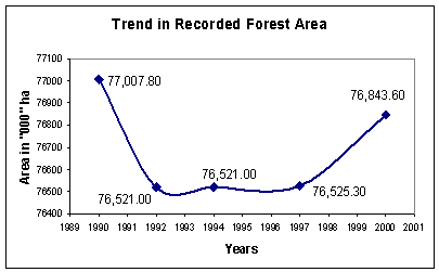
Following figures present the temporal data on recorded forest area in India.
Figure 1: Trend in Recorded Forest Area
Assessment
The recorded forest area is increasing after a decline in 1992 and is approaching level of 1990. The trend of change is positive and indicates societal support and is a healthy trend.
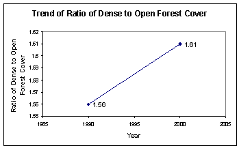
Sustenance and development of a society depends to a large extent on the judicious management of its natural resources - renewable as well as non-renewable. Therefore, it is essential to ensure sustainability of forests resources on a regular basis. Periodic assessment of forest cover (National Reporting Table No. 1) i.e. monitoring of forest cover (above 10 percent crown density) is necessary but is not sufficient. It is equally important to see how the composition of forest cover by crown density classes is changing over time. India considers that to initiate efforts in this directions it is necessary to observe over time the ratio of Dense (more than 40 percent crown density) to Open ( 10 to 40 percent crown density) forest cover and later to increase more categories like adding close (40 to 70 percent crown density) and modifying dense (more than 70 percent crown density) forest cover etc.
Definitions
Terms |
Definition |
Dense Forest |
All lands with a forest cover with canopy density of 40 percent and above. |
Open Forest |
All lands with a forest cover with a canopy density of 10 to 40 percent. |
Transformation Not necessary
Data and Temporal Trend
Following figure presents data and the temporal trend in relative composition of forest cover.
Assessment
The share of dense forest cover is increasing which is a good sign for the sustenance of forest resources.
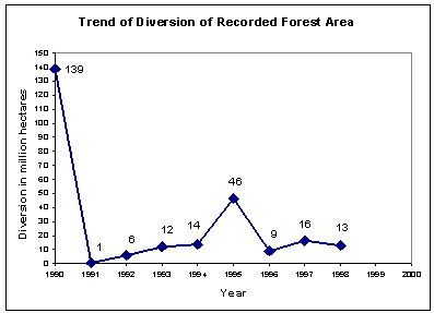
The scarcity of land in India leads to the official diversion of public forest land (recorded forest area) for non-forest purposes for taking up development activities (major irrigation dams, mining, and laying of transmission lines etc.) and meeting social objectives (rehabilitation of people) including shifting cultivation. This variable is an essential and important variable as it has direct link with extent of forests.
Terms |
Definition |
Diversion of Recorded Forest Area for Non-Forest Purposes |
Use of any forest land or any portion thereof any non-forest purpose: Explanation The "non-forest purpose" means the breaking up or clearing of any forest land or portion thereof for, - the cultivation of tea, coffee, spices, rubber, palms, oil-bearing plants, horticultural crops or medicinal plants; - any purpose other than reforestation; but does not include any work relating or ancillary to conservation, development and management of forests and wildlife, namely, the establishment of check-posts, fire lines, wireless communications and construction of fencing, bridges and culverts, dams, waterholes, trench marks, boundary marks, pipelines or other like purposes. (Source: Forest Conservation Act, 1980) |
Transformation Not necessary
Data and Temporal Trend
Following figure gives an overview of diversion of forest lands during 1990 to 2000. It indicates decline in diversion in recorded forest area.
Assessment of Variable
The decline trend of diversion is good for forest conservation and is a healthy sign.
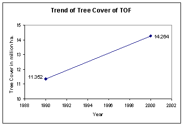
Since late seventies, India is supporting a massive programme to enhance, promote and support development and conservation of the stock of Trees Outside Forests (TOF) to supplement satisfaction of demand of forest tree products and to reduce burden on natural forests. The inventory data provides an estimate of species wise and diameter wise average number of trees per hectare a stratum or zone. A relationship between diameter of each tree species and its crown area for each zone has been developed to estimate tree cover (crown cover) of TOF. The word tree cover is different then forest cover as it is the estimated crown area of TOF with theoretical crown density of 70 percent assuming that all trees are together at one place.
Definition of Trees Outside of Forests
Terms |
Definition |
Trees |
A woody perennial with a single main stem, having 10 cm or more diameter at breast height (1.37m). If there are several stems then those which has attained 10 cm diameter at breast height (dbh) will be considered as individual trees. |
Trees Outside Forests (TOF) |
Trees on lands (rural and urban) outside the Recorded Forest Area. |
Tree Cover |
Estimated notional area of a block with tree cover with crown cover density of seventy percent assuming hypothetically that all Trees Outside of Forests are placed at one location in that block. |
Temporal Trend
FSI has developed a regression based relationship between annual area of plantation and number of planted trees for estimating number of TOF in 1990 and 1980.
Assessment
The tree cover is increasing is a healthy trend for the sustenance of forest resources.
The working plan (management plan) for scientific working of forests in India dates back to 1870. The forest policy provides implementation guidelines for forestry work. The current national forest policy (1988) explicitly provides that No forest should be permitted to be worked without the Government having approved the management plan, which should be in a prescribed format and in keeping with the National Forest Policy. The basic aim of all the management plans is to ensure sustainability of forest resources. Therefore the area of forest covered by management plans is an indicator of presence of a system to ensure sustainability of the forest resources. Specifically, these plan document for working in forest area is called "Working Plan" and for conservation of Protected Area is called Management Plan. However, in general, the management plans stands for both working plans and management plan.
Data and Temporal Trend
Most of the recorded forest area has been under working plans for many decades. The remaining areas are being steadily brought under management plans (including working plans). The following figures indicates state of forest area under management plans in 1990 (actual data is for 1987) and 2000 (actual data is for 2002).
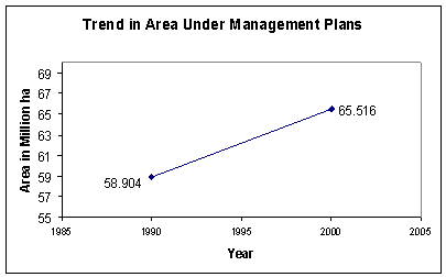
Assessment
The progressively increasing forest area under scientific management plans indicates very positive commitment of the government and public for sustainability of natural resources.
This subsection provides information on the method and approach chosen to identify and asses the complementary national variables and then the national data and its assessment.
The for identification and assessment of variables, India through FSI used the Group Convergence Method (GCM) (Govil, 2002). Two workshops were organized one for briefing and explaining and second for implementation of Group Convergence Method to arrive the finalist of identified variables. Temporal trends were developed and GCM was used to assess the state and change in these variables with respect to sustainability of forest resources.
India has identified Carbon in Trees outside forests a national variable that in addition to the three global variables ( Carbon in above ground biomass, Carbon in below ground biomass and Carbon in Soil) is essential to explain the state of Contribution to Global Carbon Cycle in India and for which some information was available.
Following table indicates sources of data for this additional variable.
Additional Variable |
Source |
Carbon in Trees Outside Forests |
Pilot Study to review sustainability of forests in India. FSI, 2003 |
This section provides information on the identified complementary national variable Carbon in Trees Outside Forest. It contains relevant definition, data, temporal trend and its assessment. The TOF now constitute a very significant part of ecosystem as well as production. There extent now define the level and nature of stress on forests in other words TOF is now an important factor in the sustainability of forest resources in India.
Definition
Term |
Definition |
Trees Outside Forests |
Tree wealth existing outside recorded forest areas |
Transformation Not needed
Data and Temporal Changes
FSI has inventories TOF both in rural and urban areas (as defined by Census of India) to estimate the number of trees and their volume. It has used pre-established relationships between diameter of a tree species and its volume within a zone to estimate volume and biomass (with the help of information on its specific density). FSI has aggregated this data to zones (stratum) using ratio method. While extrapolation, it has excluded the land that does not support vegetation such as wetlands; riverbeds and perennial snow covered mountains.
FSI has used specific factors for species to estimate the carbon content from the biomass estimates and where such information was not available for any species, a default value of 45 % of biomass has been used. FSI has generated direct primary information for the year 2000 based on its field work from 1997-2002. FSI has developed an estimate of area, number of trees, volume and biomass of TOF in 1990 using average annual plantation rates. Following table and figure indicate this information.
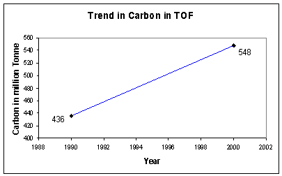
Growing stock (million cum) |
Biomass (million tonne) |
Carbon (million tonne) | |
1990 |
1771 |
945 |
436 |
2000 |
2225 |
1187 |
548 |
Assessment
The above information indicates that the carbon content of TOF is increasing in India, which is a very good sign. A complementary pilot study by FSI indicates that the estimated rate of increase of carbon content in TOF during 1990 to 2000 period is actually less than during previous decade (1980 to 1990) may be due to lower level of planting activities in previous decade.
