


Slide 1
Forest Resources Assessment
1/16
Global Forest Resources Assessment
Information Framework and Remote Sensing Survey of Forest Cover Changes
Anne Branthomme
National correspondents training
Global Forest Resources Assessment, FAO
19 November 2003, Rome
Slide 2
Forest Resources Assessment
2/16
Why an independent remote sensing survey?
To complement the assessment based on existing country information (calibrate and validate national data)
Valid at global and regional levels
To provide detailed and reliable information on the process of on-going changes in the forest cover (deforestation, forest fragmentation, degradation...)
To assess forest area and forest area changes, study of the trends (statistical estimates with known precision)
Help in thematic studies: Identify causal mechanisms of deforestation, biodiversity, ecosystem assessments…
Slide 3
Forest Resources Assessment
3/16
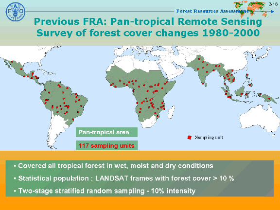
Previous FRA: Pan-tropical Remote Sensing Survey of forest cover changes 1980-2000
Pan-tropical area
117 sampling units
Covered all tropical forest in wet, moist and dry conditions
Statistical population : LANDSAT frames with forest cover > 10 %
Two-stage stratified random sampling - 10% intensity
Slide 4
Forest Resources Assessment
4/16
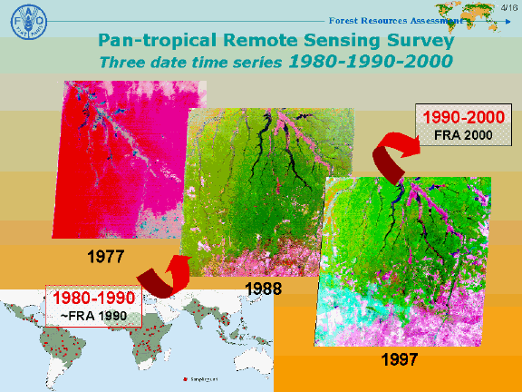
Pan-tropical Remote Sensing Survey
Three date time series 1980-1990-2000
1990-2000
FRA 2000
1977
1980-1990
~FRA 1990
1988
1997
Slide 5
Forest Resources Assessment
5/16
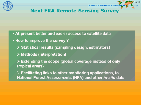
Next FRA Remote Sensing Survey
At present better and easier access to satellite data
How to improve the survey ?
Statistical results (sampling design, estimators)
Methods (interpretation)
Extending the scope (global coverage instead of only tropical areas)
Facilitating links to other monitoring applications, to National Forest Assessments (NFA) and other in-situ data
Slide 6
Forest Resources Assessment
6/16
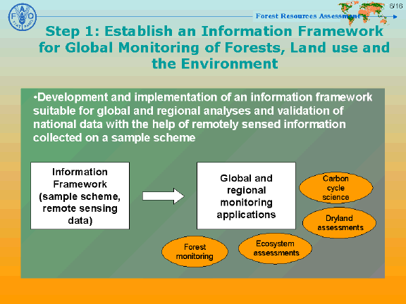
Step 1: Establish an Information Framework for Global Monitoring of Forests, Land use and the Environment
•Development and implementation of an information framework suitable for global and regional analyses and validation of national data with the help of remotely sensed information collected on a sample scheme
Information Framework
(sample scheme, remote sensing data)
Global and regional monitoring applications
Carbon cycle science
Dryland assessments
Forest monitoring
Ecosystem assessments
Slide 7
Forest Resources Assessment
7/16
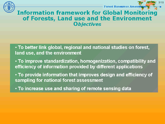
Information framework for Global Monitoring of Forests, Land use and the Environment Objectives
To better link global, regional and national studies on forest, land use, and the environment
To improve standardization, homogenization, compatibility and efficiency of information provided by different applications
To provide information that improves design and efficiency of sampling for national forest assessment
To increase use and sharing of remote sensing data
Forest Resources Assessment
8/16
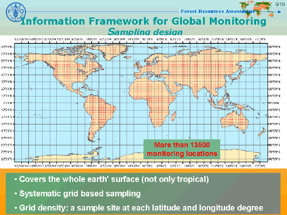
Information Framework for Global Monitoring
Sampling design
More than 13500 monitoring locations
Covers the whole earth' surface (not only tropical)
Systematic grid based sampling
Grid density: a sample site at each latitude and longitude degree
Slide 9
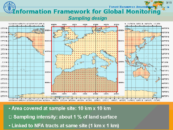
Information Framework for Global Monitoring
Sampling design
Forest Resources Assessment
9/16
Area covered at sample site: 10 km x 10 km
➾ Sampling intensity: about 1 % of land surface
Linked to NFA tracts at same site (1 km x 1 km)
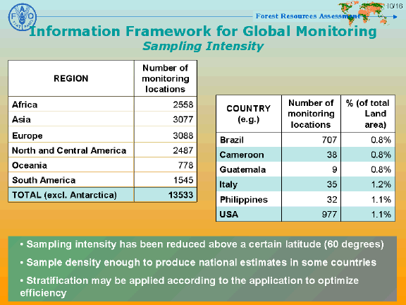
Information Framework for Global Monitoring Sampling Intensity
Forest Resources Assessment
10/16
REGION
Number of monitoring locations
Africa
2558
Asia
3077
Europe
3088
COUNTRY
(e.g.)
Number of monitoring locations
% (of total Land area)
North and Central America
2487
Brazil
707
0.8%
Oceania
778
Cameroon
38
0.8%
South America
1545
Guatemala
9
0.8%
TOTAL (excl. Antarctica)
13533
Italy
35
1.2%
Philippines
32
1.1%
USA
977
1.1%
Sampling intensity has been reduced above a certain latitude (60 degrees)
Sample density enough to produce national estimates in some countries
Stratification may be applied according to the application to optimize efficiency

Information Framework for Global Monitoring
Contents and access
Forest Resources Assessment
11/16
Remote sensing data : high-resolution and very-high resolution satellite data (Landsat, Spot, IRS, Ikonos…), aerial photos…
Time- series (5-10 year intervals)
Other data sets : medium or low-resolution satellite data (phenological information and digital elevation/terrain models)
Open and immediate access to the content
Data distribution and input of standardized interpreted results : Internet interface
To ensure neutrality and longevity to the framework by locating the governance of the platform in the UN organizations like FAO and UNEP
Slide 12
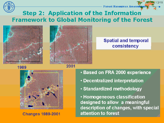
Step 2: Application of the Information Framework to Global Monitoring of the Forest
Forest Resources Assessment
12/16
Spatial and temporal consistency
1989
2001
Changes 1989-2001
Based on FRA 2000 experience
Decentralized interpretation
Standardized methodology
Homogeneous classification designed to allow a meaningful description of changes, with special attention to forest
Slide 13
Forest Resources Assessment
13/16
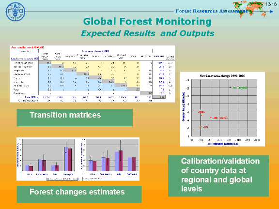
Global Forest Monitoring
Expected Results and Outputs
Transition matrices
Forest changes estimates
Calibration/validation of country data at regional and global levels
Organisation
Forest Resources Assessment
14/16
Build on past experience and networks of partners
To establish institutional arrangements to maintain and sustain the information framework and regularly expand its content
Partnerships with space agencies and their affiliates are essential for data provision and data processing for the specified needs (input of the contents will be facilitated by GTOS, GOFC-GOLD and others)
Science and research community will ensure continued evolution and improvement in the methods and technologies used under the umbrella of information framework
FAO and UNEP will coordinate with countries, define information needs and will host, store and provide the contents of the information framework freely
Work plan
Forest Resources Assessment
15/16
Initially, the information framework will contain for each sample site two dates-time series of high-resolution satellite data (1990, 2000, Landsat data sets to start with)
➜ End 2003
FAO will develop and support formulation of standard methodologies for use of the information framework to forest monitoring and will undertake pilot studies in Central Africa and possibly in other places
➜ Beginning 2004
FAO will coordinate and organize training of national experts to facilitate decentralization of the interpretation work
➜ Results to be included in the Global Forest Resources Assessment 2005 (FRA 2005)
Slide 16
Forest Resources Assessment
16/16
Thank you
