


Slide 1
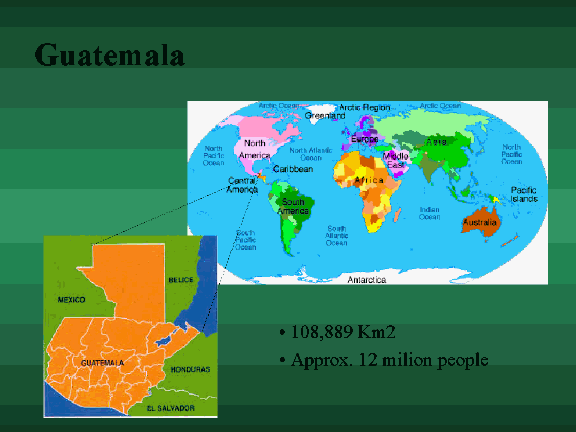
Guatemala
108,889 Km2
Approx. 12 milion people
Slide 2
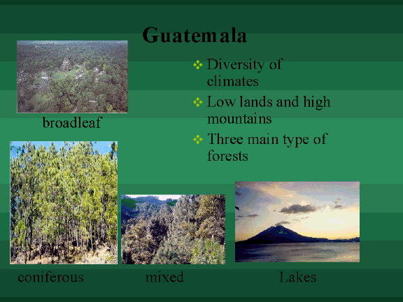
Guatemala
broadleaf
v Diversity of climates
v Low lands and high mountains
v Three main type of forests
coniferous
mixed
Lakes
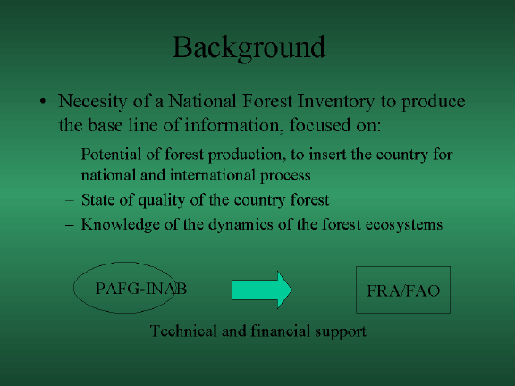
Background
• Necesity of a National Forest Inventory to produce the base line of information, focused on:
– Potential of forest production, to insert the country for national and international process
– State of quality of the country forest
– Knowledge of the dynamics of the forest ecosystems
PAFG-INAB
FRA/FAO
Technical and financial support
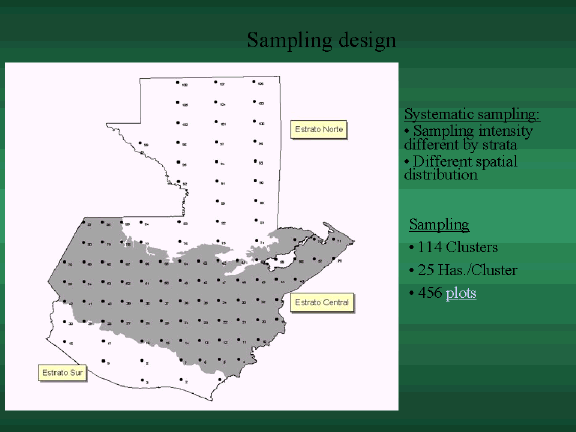
Sampling design
Systematic sampling:
Sampling intensity different by strata
Different spatial distribution
Sampling
114 Clusters
25 Has./Cluster
456 plots
Slide 5
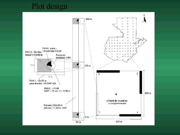
Plot design

Vegetation classifying system
Country total area
Forest
Other wooded land
Other land
Inland
water
Level 1
Types of forests
Shrubs
Wooded grass land ctt 5-10%
Fallow
Marshland
ctt 5-10%
Barren land
Annual and perennial
agriculture
Grassland
Built up area
Level 2
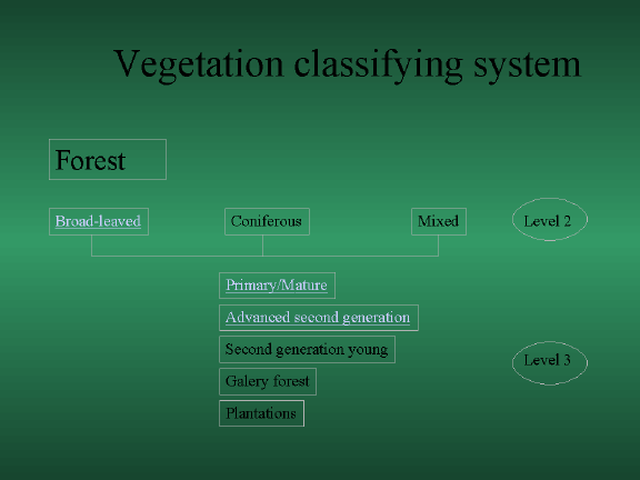
Vegetation classifying system
Forest
Broad-leaved
Coniferous
Mixed
Level 2
Primary/Mature
Advanced second generation
Second generation young
Level 3
Galery forest
Plantations
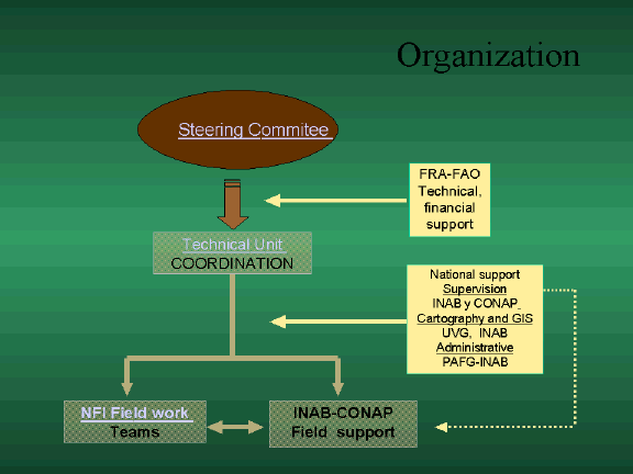
Organization
Steering Commitee
FRA-FAO
Technical, financial support
Technical Unit COORDINATION
National support
Supervision
INAB y CONAP
Cartography and GIS
UVG, INAB
Administrative
PAFG-INAB
NFI Field work
Teams
INAB-CONAP
Field support
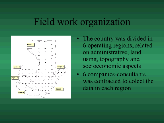
Field work organization
• The country was divided in 6 operating regions, related on administrative, land using, topography and socioeconomic aspects
• 6 companies-consultants was contracted to colect the data in each region

Data output
• Based on FRA criteria:
Extension of forest
Production function
Protective function
Biodiversity conservation function
Socioeconomic function
Health and deseases

Land Use Areas
Variables
Forest
OWL
OL
Inland
Water
Area tot.
(‘000 ha)
4,046
1,802
4,611
208
% of tot. land area
39
17
44
Forest Type Areas
Variables
Coniferous
Broad-leaved
Mixed
Area total
(‘000 Has.)
397
3,336
313
% of tot. forest area
10
82
8

Total Tree Volume (>20cm Dbh)
Variables
Forest
OWL
OL
TOT.
Volume tot.
('000 m3)
469,389
26,504
66,529
562,423
% of tot. Vol.
83
5
12
100
Total Tree Volume by forest type
Variables
Coniferous
Broad-leaved
Mixed
TOT.
Volume tot.
('000 m3)
24,685
427,075
17,629
469,389
Tot. vol. per ha (m3/ha)
62
128
56
116
Slide 13

Forest Products
% using
Product
Forest Services
% using
service
Leña
65
Biodiversity refuge
79
Madera
38
Alimento-vegetal
11
Hunting
76
Planta ornamental
10
Soil Protection
76
Animales silvestres - carne
9
Water Protection
60
Construcción rural - poste
9
Grassing in Forest
51
Planta medicinal
8
Construcción rural - techos
6
Tourism/recreation
50
Artesanía
6
Religious or spiritual
47
Resina
6
Scientific
38
Ocote
5
Other
4
Construcción rural - madera
5
Broza
5
Shade
2
Caseria deportiva
4
Condimento
4
Cera y miel
3
Animales silvestres - pieles
3
Forraje
2
Semillas forestales
2
Herramientas
2
Construcción rural - acículas para adobe
1
Animales silvestres - venta
1
Mecate
1
Carbón
0.6
Construcción rural - corteza para amarre
0.6
Construcción rural - varas
0.6
Ganado
0.3
Construcción rural - corteza
0.3
Costrucción rural - vigas
0.3
Taninos
0.3
Slide 14

Enterprise
Fuelwood
(%)
Tot. Prod.
(%)
End Use
Tot. Products
(%)
Informal
89
97
Comercial
38
Formal
11
3
familiar
73
Awareness of Forest Incentives
All Land Uses
(%)
User Conflicts
Tot. Products
(%)
Yes
42
Conflicts exist
10
No
58
No conflicts recorded
86
Not known
4
Expected future trees
All Land Uses
(%)
Desired future trees
All Land Uses
(%)
More
39
More
46
Equal
13
Equal
13
Less
14
Less
12
No opinion
34
No opinion
29
