![]()
![]()
![]()
by
D.J. Boland and G.F.J. Moran
Division of Forest Research, CSIRO
P.O. Box 4008
Canberra A.C.T. 2600
Australia
During 1977–78 seed and herbarium voucher specimens were collected from 65 provenances of Eucalyptus delegatensis R.T.Bak. The seed will be used mainly by the Division of Forest Research, CSIRO for laboratory and field studies, but small quantities are available for provenance trials overseas. 1)
INTRODUCTION
E. delegatensis is one of Australia's most important hardwoods. The timber is widely used for general construction purposes and for pulp and paper. The species has not been planted widely as an exotic as it has performed well only on certain favourable sites, but this may be due in part to the use of unsatisfactory provenances.
The aim of the 1977–78 E. delegatensis collections was to investigate the geographic variation and breeding systems within the species and to establish field provenance trials at several sites in Australia.
The purpose of this article is to inform readers of these recent collections and to offer seed for further field trials overseas. Such trials should be of interest to those countries seeking better performing provenances of a relatively fast growing, cold tolerant eucalypt with good wood properties.
NATURAL DISTRIBUTION
The natural distribution of E. delegatensis is broadly indicated in Fig.1. Its latitudinal range is from about 35°S to 43°S and its altitudinal range from approximately 160 m to 1500 m. The species has a mosaic distribution over its range with each population being relatively pure in composition and extending from about 1 to many hundreds of hectares. Common associates include Eucalyptus dalrympleana Maid. and E. obliqua L'Herit. at lower elevations and E. pauciflora Sieb. ex Spreng. at higher elevations. The age structure of most populations is relatively uniform due to natural regeneration from past wildfires.
E. delegatensis is a very cold tolerant eucalypt and is the main commercial eucalypt in the high altitude regions of Australia. Climatic data for three representative meteorological stations, viz. Pilot Hall (near Batlow) New South Wales, Mt Buffalo Victoria, and Maydena Tasmania, are shown in Table 1. Most populations would receive several months of snow each year and the mean annual rainfall would range from 890 to 2500 mm per annum.
The species prefers well-drained soils on moderately steep slopes and usually occurs on the sides of mountain ranges (on the mainland) or on the edges of plateaux (in Tasmania). On the mainland the parent materials are commonly granites and less commonly basalts, porphyrys, phyllites and schists. In Tasmania the species commonly grows on dolerites and less commonly on granites (one small area near Scottsdale), basalts, sandstones, schists and porphyrys.
SAMPLING TECHNIQUES AND COLLECTIONS
The species was sampled over the whole of its natural range and 65 sites were chosen (see Fig.1 and Table 2) to cover a wide selection of environmental variables, such as climate, rainfall, geology, altitude, etc.
The collections were made in 1977 and early 1978 and took nearly three months to complete. Dr. M.D. Wilcox, Forest Research Institute, Rotorua, New Zealand, who is planning some E. delegatensis field trials in New Zealand, accompanied the party for part of the Victorian collections. At each site usually five, but occasionally ten, trees were selected for sampling. In one locality in each of three States, viz. N.S.W., Viz., and Tas., 30 trees were sampled for more intensive studies. Seed of all mother trees was kept separate. Most of the collections were made with the aid of a .308 calibre rifle.
SEED AVAILABILITY
Only small amounts of seed per tree (generally less than 100 g) were collected. Most of this seed will be used by the Division of Forest Research, CSIRO for laboratory and glasshouse studies and for the establishment of field trials in Australia. In addition, a small amount of seed of each tree has been placed in cold storage for genetic conservation purposes. Nevertheless, small quantities of seed are available for field provenance trials on an exchange or sale basis ($6.00 Aust. per sample packet). We are also willing to advise on the choice of suitable provenances, field layout, design and planting techniques.
ESTABLISHMENT OF FIELD TRIALS IN AUSTRALIA AND NEW ZEALAND
One field trial was established near Batlow, N.S.W. in August 1978 in co-operation with the Forestry Commission of N.S.W. This trial consisted of an 8 × 8 balanced lattice square design with 64 populations and six-tree row plots. It is proposed that a further three trials will be established in 1979 in Tasmania in co-operation with the Forestry Commission, Tasmania and two private forestry companies.
Dr. M.D. Wilcox, Forest Research Institute, Rotorua is planning to establish three trials in New Zealand during November 1978. These will be at Rotoaira Forest, Golden Downs Forest and Longwood Forest at altitudes of 700, 210 and 100 m respectively. At each site a randomised complete block design will be implemented using 36 provenances, seven replications and with 6 single tree plots per provenance per replication. It is anticipated that some local, exotic New Zealand E. delegatensis provenances will also be incorporated in this design. At one test site, Rotoaira Forest, all the remaining Australian provenances will be used to allow for comparisons of Australian and New Zealand results.
ACKNOWLEDGEMENTS
The maps were prepared by Mrs. M. Risby of the Division of Forest Research CSIRO. Messrs. C. Bell, E. Cole, D. Kleinig, P. Martensz, T. Rout and J. Turner assisted with the collections. Dr. M. Wilcox provided information on the New Zealand field provenance trials.
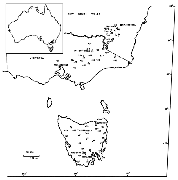
Fig.1 E. delegatensis seed collection sites. The overall distribution of the species is shown in insert (map from “Forest Trees of Australia” by N. Hall, R.D. Johnston and G.M. Chippendale, published 1975 by A.G.P.S., Canberra.)
Table 1. Climatic data for three meteorological stations (Pilot Hill, Mount Buffalo, Maydena)1
| Location details | Temperature in the shade (°C) | ||||||||
| Name and State | latitude (°S) | longitude (°E) | altitude (m) | January | July | Average no.of frosts per year | Mean annual rainfall (mm) | ||
| Mean min. | Mean max. | Mean min. | Mean max. | ||||||
| Pilot Hill, N.S.W. | 35°36' | 148°06' | 670 | 10.3 | 23.5 | -1.5 | 6.0 | 100.3 | 1320 |
| Mt Buffalo, Vic. | 36°42' | 148°48' | 1330 | 11.0 | 19.4 | -0.8 | 3.6 | 71.1 | 1932 |
| Maydena, Tas. | 42°48' | 146°36' | 267 | 7.9 | 21.7 | 0.9 | 8.2 | unknown | 1145 |
Table 2. Location details for Eucalyptus delegatensis provenances
| Provenance No. | Locality | Latitude (S) | Longitude (E) | Elevation (m) |
| 1 | Yaouk Bill Range, A.C.T. | 35°55' | 148°54' | 1340–1525 |
| 2 | Leura Gap, A.C.T. | 35°38' | 148°47' | 1500–1350 |
| 3 | Smokers Flat, A.C.T. | 35°32' | 148°54' | 1310 |
| 4 | Mt Bogong, N.S.W. | 35°36' | 148°28' | 1525 |
| 5 | Clear Creek, N.S.W. | 35°39' | 148°10' | 1230–1250 |
| 6 | The Granites, N.S.W. | 35°44' | 148°13' | 1370–1400 |
| 7 | Mt Nurenmerenmang, N.S.W. | 35°50' | 148°18' | 1220–1240 |
| 8 | Mt Black Jack, N.S.W. | 35°56' | 148°20' | 1400–1460 |
| 9 | Cascade, N.S.W. | 36°36' | 148°15' | 1400 |
| 10 | Youngal, N.S.W. | 36°24' | 148°08' | 1130 |
| 11 | Geehi, N.S.W. | 36°21' | 148°16' | 1140 |
| 12 | The Pinnacle, N.S.W. | 36°20' | 148°14' | 1500 |
| 13 | Dargals Range, N.S.W. | 36°10' | 148°14' | 1180–1300 |
| 14 | Mt Flinders, N.S.W. | 35°57' | 149°03' | 1360 |
| 15 | Peppercorn Hill, N.S.W. | 35°34' | 148°57' | 1400 |
| 16 | Yarrangobilly, N.S.W. | 35°42' | 148°30' | 1260 |
| 17 | Gungarlin River, N.S.W. | 36°17' | 148°30' | 1210–1300 |
| 18 | Bald Hill, N.S.W. | 36°09' | 148°35' | 1410 |
| 19 | Pilot Hill, N.S.W. | 35°37' | 148°09' | 1100 |
| 20 | Mt Wills, Vic. | 36°47' | 147°28' | 1200–1280 |
| 21 | Beecher Hill, Vic. | 37°07' | 146°58' | 1200 |
| 22 | Mt Buffalo, Vic. | 36°43' | 146°48' | 1350 |
| 23 | Big Hill, Vic. | 36°47' | 147°12' | 1005 |
| 24 | Big Ben, Vic. | 36°24' | 146°56' | 1100 |
| 25 | Razorback Spur, Vic. | 37°05' | 146°26' | 1280 |
| 26 | Upper Howqua, Vic. | 37°08' | 146°33' | 975–1160 |
| 27 | Royston River Road, Vic. | 37°23' | 145°52' | 960 |
| 28 | Lake Mountain, Vic. | 37°30' | 145°53' | 1310 |
| 29 | Mt Macedon, Vic. | 37°24' | 144°36' | 945 |
| 30 | Ada River, Vic. | 37°48' | 145°49' | 925 |
| 31 | Mt Useful, Vic. | 37°40' | 146°31' | 1220 |
| 32 | Mt Skene, Vic. | 37°24' | 146°21' | 1150 |
| 33 | Mt Ewen, Vic. | 37°22' | 147°11' | 1230 |
| 34 | Mt Baldhead, Vic. | 37°22' | 147°32' | 1220 |
| 35 | Hartz Mountain, Tas. | 43°13' | 146°52' | 560 |
| 36 | Plateau Road, Tas. | 43°02' | 147°54' | 550 |
| 37 | Ben Lomond, Tas. | 41°31' | 147°39' | 1220 |
| 38 | Ben Nevis. Tas. | 41°22' | 147°40' | 820 |
| 39 | Dazzler Range, Tas. | 41°13' | 146°43' | 480 |
| 40 | Cluan Tier, Tas. | 41°37' | 146°47' | 550 |
| 41 | Maggs Mountain, Tas. | 41°46' | 146°11' | 820 |
| 42 | 31 Mile Road, Surrey Hills, Tas. | 41°20' | 145°40' | 580 |
| 43 | Yellow Marsh Road, Tas. | 41°28' | 145°47' | 660 |
| 44 | Luina, Tas. | 41°28' | 145°22' | 457 |
| 45 | Heemskirk River, Tas. | 41°48' | 145°12' | 160 |
| 46 | King William Saddle, Tas. | 42°12' | 146°08' | 800 |
| 47 | Miena, Tas. | 42°01' | 146°47' | 960 |
| 48 | Tunbridge Tier, Tas. | 42°07' | 147°16' | 820 |
| 49 | Mt Dromedary, Tas. | 42°43' | 147°06' | 800 |
| 50 | Lake Pedder, Tas. | 42°58' | 146°22' | 380 |
| 51 | Russell River, Tas. | 42°54' | 146°44' | 500 |
| 52 | Maydena, Tas. | 42°33' | 146°34' | 650 |
| 53 | Middle Peak, Tas. | 42°43' | 147°59' | 500 |
| 54 | Lake Tooms, Tas. | 42°14' | 147°51' | 600 |
| 55 | Bicheno, Tas. | 41°53' | 148°12' | 460 |
| 56 | Fingal Tier, Tas. | 41°40' | 148°05' | 760 |
| 57 | Bendover Hill, Tas. | 41°17' | 147°55' | 550 |
| 58 | near Mt Gibbo, Vic. | 36°37' | 148°01' | 1310 |
| 59 | along Forlorn Hope Track, Vic. | 36°56½' | 148°09' | 1400 |
| 60 | Bulls Head, A.C.T. | 35°24' | 148°49' | 1100–1150 |
| 61 | Mt Delegate, N.S.W. | 37°07' | 148°54' | 880–950 |
| 62 | Mt Ellery, N.S.W. | 37°23' | 148°47' | 1150 |
| 63 | Nunniong Plateau, Vic. | 37°06' | 147°58' | 1320 |
| 64 | Cromwell Knob, Vic. | 37°30' | 146°55½' | 1280 |
| 65 | Maria Island, Tas. | 42°37' | 148°06' | 450 |
![]()
![]()
![]()