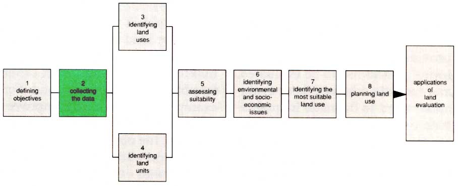
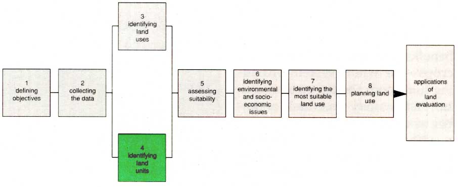
1. Defining objectives
2. Collecting the data
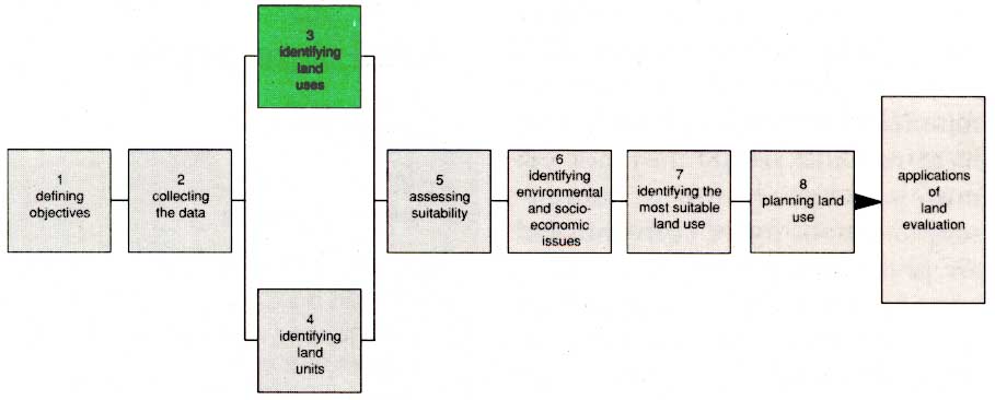
3. Identifying land uses
4. Identifying land units
5. Assessing suitability
6. Identifying environmental and socio-economic issues
7. Identifying the most suitable land use
8. Planning land use
'The essence of land evaluation is to compare or-match the requirements of each potential land use with the characteristics of each kind of land.'
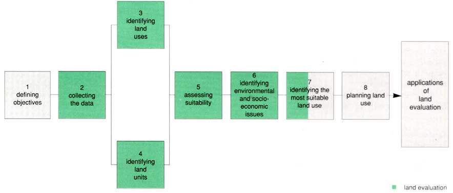
Land evaluation is part of the process of land-use planning. Each step is discussed separately in the pages that follow.
Once the objectives of the study have been established, the collection of basic data can begin. At this stage, there are two main aims: one is to catalogue the different types of land that exist in the study area; and the second is to identify the possible uses to which they might be put.
The essence of land evaluation is shell to compare or match the requirements of each potential land use with the characteristics of each kind of land. The result is a measure of the suitability of each kind of land use for each kind of land. These suitability assessments are then examined in the light of economic, social and environmental considerations in order to develop an actual plan for the use of land in the area. When this has been done, development can begin.
Land evaluation, strictly speaking, is only that part of the procedure that lies between stages two and six on the diagram below. Stage seven is a transitional step between land evaluation and land-use planning. The powerful interactions that occur between all the stages mean that the planning process must be approached as a whole. The requirements of the different kinds of use that are to be evaluated, for example, largely determine the range of basic data that must be collected before evaluation can begin. Later, the identification of suitable forms of land use provides the building blocks for land-use planning.
Ideas on how the land should be used are likely to exist before the formal planning process begins. These ideas, which often reflect the wishes of the local people, are usually included among the possible uses to be assessed in the evaluation and will thus influence the range of basic data that needs to be collected.
As the study proceeds, new ideas on the way the different types of land could be used will emerge. Not only will these need to be evaluated but, conceivably, additional basic data will need to be collected. The original objectives of the study may even need revising.
Thus, the overall procedure requires more than a simple passage through the flow chart. It is the norm rather than the exception that the procedure cycles backwards and forwards through the stages of the chart until the planners are satisfied that all important possible uses have been evaluated.
A wide range of specialist knowledge is needed to collect and analyse all the data relevant to land evaluation. The work is best undertaken by a multidisciplinary team that includes social and economic expertise as well as biophysical scientists. Ideally, such a team should work together throughout the study so that each member can influence the others with his or her special knowledge and viewpoint.
In practice it is not always possible to field the whole team at once. In this case, the physical aspects of land are usually studied and mapped first to provide a geographical framework into which the socio-economic dimensions are inserted later. A two-stage approach is obviously less well integrated and will take longer to complete.
The reliability of a land evaluation can be no greater than that of the data on which it is based. Ideally, fresh data should be obtained to answer all questions raised by the study, although time and expense usually prevent this being done as thoroughly as is possible. The one really important requirement is that the reliability of each data source is checked. Any shortcomings that are not subsequently made good should be highlighted in the evaluation report.
In order to be objective and, as far as possible, quantitative, land evaluation follows certain established procedures based on the concept of land 'qualities' and 'characteristics'. Land characteristics are single factors such as annual rainfall or soil texture/ which can be measured or estimated. Land qualities, on the other hand, are complex proper ties of the land such as moisture availability or fertility, produced by combination groups of land characteristics. Land suitability is rated for a given use by comparing the requirements of that use, which must of course first be identified, with the qualities of the land unit.
The evaluation process can be 'automated' and carried out quite rapidly once all the necessary data are available, by setting up a computerized data bank or geographical information system, and establishing rules or decision trees to carry out the matching process which produces the evaluation.
Land evaluation
concepts |
|
land suitability is evaluated
for specific types of land use |
land use may be defined either at
a general level (such as rainfed arable cropping) or as a
particular crop at a specified level of inputs |
evaluation includes a
consideration of inputs and projected outputs |
the level of material inputs is
defined in the evaluation as are land improvements such
as soil conservation or drainage and their overall impact
is taken into account in predicting crop yields or
outputs |
land evaluation requires
specialists of different disciplines |
the land evaluation team must
coordinate surveys and work in consultation with soil
scientists, agroecologists, socioeconomists and planners |
evaluation relates to the
environmental and socio-economic conditions of the area |
evaluation recommendations should
relate to existing farming systems and to changes in land
use which are technically feasible and socially and
politically acceptable |
suitability refers to use on a
sustained basis |
recommended land uses must not
cause soil erosion but must conserve the land for
long-term production |
evaluation involves comparison
of more than one land use |
improving the productivity of land
use systems may involve introduction of new crops,
changes in land management or other innovations in the
existing farming system |
'The most significant decisions at this stage relate to the levels of planning that the study must serve, because these determine the precision of evaluation and thus the intensity of every aspect of the investigation.'
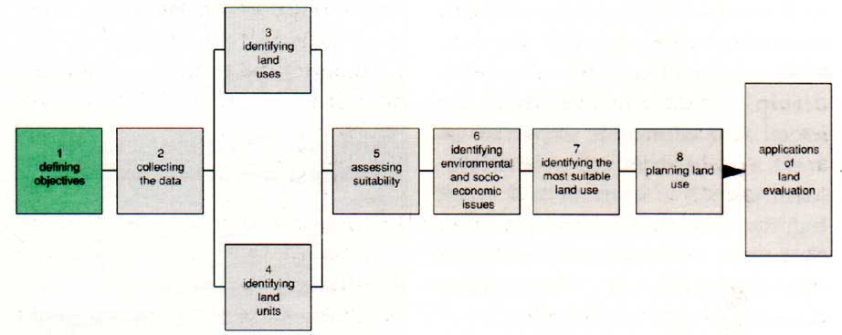
The definition of objectives is a critical step in the evaluation procedure. It largely determines how elaborate the study must be, how long it will take and how much it will cost. It also ensures that the investigations set off in the right direction, with a good chance of providing all the advice that the planner will need. The procedure allows for minor revision of the initial objectives in the course of a study but a major change at a late stage would be likely to involve repetition of field work at considerable cost.
The most significant decisions at this stage relate to the levels of planning that the must serve national, district, or individual farm because these determine the precision of evaluation required and thus the intensity of every aspect of the investigation. Any small increase in the intensity with which the study is carried out can represent a major increase in study duration and cost, so inappropriate detail must be avoided during the study. Often, the most efficient approach is to phase the study through successive stages of increasing detail.
A start might be made with a rapid overview of a whole region of possible interest before moving to more detailed investigation of smaller areas - each identified in the overview as having particular promise for the objectives in view. A third phase of very detailed investigations might be needed to allow planning of individual farms. Each phase requires its own defined objectives to meet the starting requirements of the next phase and, eventually, the most detailed needs of the study.
The objectives must establish the boundaries and thus the size of the study area. They must also provide a first selective list of the forms of land use to be evaluated, and indicate whether these evaluations need to be made in qualitative or quantitative form. The study team needs guidance on these issues because the choices must reflect the special interests of the planners and the aspirations of local people. Furthermore, as will be explained later, without this guidance the choice of land-use alternatives to be considered could be infinite.
In framing the objectives, the need for comparisons in land-use planning must be recognized. The prime objective of the study may be to establish the suitability of a particular kind of use, but this can be achieved most effectively by making comparisons with other feasible uses of the same land. For example, if major costly improvements such as new irrigation are planned, the objectives of the land evaluation should include comparison with existing unimproved uses of the land so that the advantages of the planned development can be truly assessed.
Environmental conservation is always an objective of land evaluation. It is assumed, therefore, that no form of land use will be judged 'suitable' unless it can be sustained on a long-term basis without significant detriment to the land.
Major stages in defining objectives Evaluation for land-use planning can be carried out on different scales, such as national, provincial or farm level. Objectives will be different at each of these levels, but the same approach is used to define objectives which in turn determine the 'best' land use for the area. The major stages are to:
|
'The range of information that could be relevant to land evaluation is huge, and collecting data which are not essential can be costly in both time and money.'
Reliable knowledge of land characteristics, and of the way these differ from place to place, is essential to good land evaluation. The kinds of data that may be needed are summarized in the box on the opposite page. In some parts of the world, much of this information is already available. Elsewhere, there is very little. Even if substantial local knowledge exists, however, some additional information will almost certainly need to be collected for any new evaluation study.
The range of data that could be relevant to land evaluation is huge, and collecting it can be costly, in both time and money. There are three main ways to minimize costs:
• focus on data that are essential to the evaluation;
• search out and make maxi mum use of existing data; and
• use new technology in data collection.
Selecting the right data is the most difficult of these economies, for it is not easy to know in advance which kinds of data will prove essential. If a need is not identified until late in the study, serious delays may ensue whilst the missing data are found.
Data selection is easier if the survey work can be phased through stages of increasing detail. A first examination of the entire area, aimed mainly at eliminating land areas that are irrelevant to the study, may well require very few kinds of data. This process can be very helpful in deciding what investigations and what data are essential for later stages. At any stage, opportunities to acquire additional data at reasonable cost should be accepted.
Seeking out existing data is not as easy as it sounds. Valuable data are often hidden in obscure archives and can be traced only by systematic enquiry. Once located, old data must be carefully compared with the present situation to establish their relevance and reliability. Satellite imagery, for example, sometimes reveals alarming inaccuracies in older maps. Despite these warnings, huge savings in time and money can be made by using earlier survey data in conjunction with such modern aids as remotely sensed imagery.
The new technology that is available for land evaluation consists mainly of the use of remote sensing and computers. Stereoscopic examination of paired, black and white, photographs obtained by conventional aerial photography - the best tested form of remote sensing - remains the mainstay for interpretation of landform, vegetation, land use, soils and geology, and for other purposes such as contouring.
Sources of data |
||
type of survey |
data source |
range of data |
satellite |
digital tapes, photographs, other
imagery |
water resources, vegetation, land
use, infrastructure, landform, soils |
aircraft |
photographs (conventional,
infra-red), radar imagery |
landform, soils, vegetation, land
use, farm boundaries, water resources, crops,
infrastructure |
ground |
reports, questionnaires, maps |
soil, climate, landform,
vegetation, land use, population, social and economic
data |
While the newer forms of remotely sensed imagery (such as infra-red and radar) may not yet match the precision or stereoscopic capability of conventional air photography, they have other advantages. Each image sensed from space covers a comparatively large area - especially helpful in analysing and mapping landform. Satellites return at regular intervals to obtain new imagery of the same sites, so that libraries of sequential imagery can be built up showing the changes at a single site over time. Satellites can now record at up to seven different wavelengths simultaneously. Radar wavelengths are particularly useful in the humid tropics because they can obtain images of the Earth through dense cloud.
Computers can now be used to store and manipulate the huge amounts of data needed in land evaluation. Tough, portable, micro-computers are being increasingly used to record, store, interpret, test and communicate data at the survey site itself.
The main impact of these new technologies has been to save time and money, and to extend the range and depth of land evaluation, allowing data 011 a greater complexity of land-use alternatives to be collected than was possible in the past.
However, many kinds of data have to be collected in traditional ways. The soil surveyor must dig or drill holes to describe the sequence of soil 'horizons' with depth. The hydrogeologist may have to drill deeper holes to prove the existence of suspected groundwater whilst hydrologists set up gauges on streams to measure surface water flow. The meteorologist has to rely on systematic measurements of change in the weather at established weather stations. Agriculturalists, economists and sociologists observe people in action in farms, villages and markets and, by means of questionnaires and other enquiries, establish the patterns of their business. Foresters and livestock specialists make inventories and observe how their respective resources are exploited, propagated and conserved. These and other scientists collect the central core of basic data on land much as they have done for decades.
What data are needed? Physical land resources
socio-economic issues
present land use
|
'The aim is to recognize and describe land utilization types that are either in existence or that could be developed.'
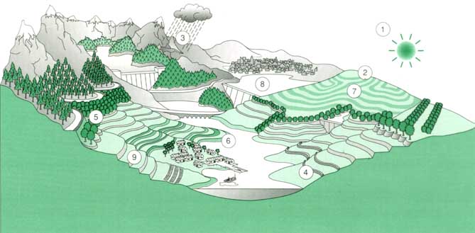
A plot of land can often be put to any one of several possible uses - but rarely with the same degree of success. One of the objectives of land evaluation is to inform this choice by assessing the suitability of each use for each land unit, and vice versa. The first step in this procedure, therefore, is to determine which forms of land use are worth considering.
In a reconnaissance study of a large area it may be sufficient to identify possible land uses in general terms, such as rainfed agriculture, irrigated agriculture, forestry and wildlife reserve, without further definition. Indeed, over a large area, the range of possible uses could be too large to handle if it were subdivided further. These sub-divisions are called major land-use types.
In more detailed studies, land use types have to be more carefully defined. Their definition must include details not only of the produce (or other objective) foreseen but also of the production method and the socioeconomic setting of production. These definitions are called land utilization types (LUTs).
The forms of land utilization that are to be evaluated, if not set out in the study objectives, need to be identified early on because this may have a bearing on the data that need to be collected. initially the descriptions can be fairly general: smallholder rainfed arable farming based on maize and cassava, improved village woodland, smallholder coffee farming and government nature reserve are typical examples.
As the work proceeds, the descriptions of the utilization types can be modified and elaborated in keeping with the overall precision of the study. Further utilization types may have to be added or substituted in the light of this new knowledge bearing in mind that such a change may require further data collection, possibly in areas where field work was thought to be completed.
Very intensive land evaluation studies could lead, by successive refinement, to the specification of utilization types that are virtually tailor made to each part of the study area. The final precise description of the farming systems concerned would then be a major part of the evaluation findings - tantamount to land-use planning. This is possible, however, only when quantitative agronomic studies are being made, and the relationships between land-use requirements and local land characteristics can be very closely examined. Normally, the aim is to recognize and describe land utilization types that are either in existence or that could be developed. Comparison of the present and future situations is important if development is planned. It is not possible to consider every form of use and management practice relevant to an area, so those that are chosen for evaluation are regarded as 'markers' against which the suitability of similar uses can eventually be judged.
Some forms of land use serve more than one objective simultaneously. In agroforestry, for example, trees are grown in close, mutually beneficial association with rainfed crops - the whole system providing fuelwood, shelter, erosion control and possibly fruits and / or timber, as well as arable crops.
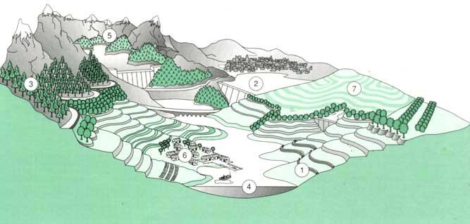
Major land uses, such as those shown in the diagram right, are identified first More detailed studies will then elaborate on land use, in some cases specifying even the exact farming systems to be used on specific areas of land, and describing the socioeconomic setting of production.
Key (1)
rainfed agriculture |
Other forms of land utilization, such as farming systems that combine livestock husbandry and arable cropping, are even more complex. Different uses occupying the land sequentially, or one use extends seasonally or periodically to different areas of land. Extensive grazing, irrigated agriculture, forestry and some other major kinds of land use also give rise to complications.
A selection of headings for the criteria that are taken into account in defining land-utilization types are shown on the right. In the matching process, land-use types are formally characterized and their qualities are compared with the requirements of land users.
Land-use types |
|
Characterized by: |
'user requirements': |
product |
physical |
|
• climate |
• land |
|
production system |
|
|
|
• inputs |
|
social setting |
social |
|
• rights and customs |
• farm size |
• managerial level |
• labour intensity |
|
• managerial level |
|
economic setting |
economic |
|
• capital requirements |
• input/output factors |
• availability of inputs |
• infrastructure |
|
'Land units, or land-mapping units, are areas with and qualities that differ sufficiently from those of other land units to affect their suitability for different land uses.'
Land units are areas of land with specific characteristics. They are normally represented within a boundary on a map in order to create visually a geographical framework, but land units can also be stored invisibly in computer memory, in terms of location and description.
Any area of land, no matter how its boundaries are defined, can be regarded as a land unit for purposes of land evaluation, provided the characteristics of the land enclosed can be adequately described. However, land evaluation can be performed more easily and its findings are likely to be more valuable if the land units on which it is based have been defined and mapped for the purpose, using available and specially collected data.
An enormous number of characteristics is required to describe a single piece of land adequately. Comparatively few of these characteristics are especially important in relation to a particular kind of land use. Of those that are, not all change at the same rate or in the same place. Thus there is often a surprising amount of choice in deciding where boundaries should be drawn. A judgement therefore has to be made on where the most significant changes occur. The aim is to enclose areas that are as nearly homogeneous as possible.
The problems are more complicated if, as is usually the case, several alternative types of land use are to be considered. It may then be necessary to make compromises in positioning the boundaries.
Some land qualities used to identify land units
In practice, land units are often defined by superimposing maps of different aspects of the land - such as climate, soils, vegetation and landform - and then drawing boundaries that best reflect the most important distinctions in the separate maps. Aerial photographs and satellite imagery are, like maps, visual summaries of land surface characteristics and they, too, are often used to divide an area up into its initial units - units that may have to be revised in the light of information on climate and from 'ground truth'.
The intensity of the study - the scale of the mapping and the degree of detail desired - is important in determining which land characteristics should be used to define the boundaries. For example, in an overview of a large region, differences in climate will largely determine these boundaries because differences in other factors, such as soils, are likely to be too localized to be investigated and mapped individually on such a small scale. Information on the nature and influence of these other factors, which may well change with climate, can be included in the description of the land units but will not determine their boundaries.
In contrast, if the evaluation is focussed on a small area, even minor differences in soils may be represented by separate land units whilst macro-climate will be assumed to be uniform across the area and will not, therefore, affect the land boundaries. Knowledge of local climate will be just as important for practical interpretation of the soil differences but, in a detailed study, climatic information is generalized and confined to the land unit description. At intermediate scales (around 1:250,000) landform is likely' to be decisive in locating boundaries, with both soils and climate contributing only to the description.
Land units can be described in terms of their characteristics, their qualities or both. A land characteristic is a fairly simple attribute that can be measured or estimated - such as mean annual rainfall or a particular texture of the soil. A land quality, on the other hand, is a complex attribute that usually reflects the interaction of many land characteristics - such as susceptibility to flooding or erosion and ability to retain nutrients. Each land quality has a distinctive influence on the suitability of land for a specified kind of use. Land qualities are very helpful in 'matching' land units with land-use requirements. Some of the land qualities important in the evaluation of rainfed crops are illustrated on page 14. The characteristics and qualities that are important in relation to some other forms of land use are dealt with on pages 24-33.
Major land qualities that are important in rainfed agriculture are shown in the illustration, left. Each of these qualities can be further subdivided; thus, the radiation regime would include measurement of both total radiation and day length, and moisture availability would include total moisture, critical periods and drought hazards.
Key (1)
radiation regime |
Typical description of
a land unit in an evaluation of suitability for rainfed
agriculture |
||
land quality |
land characteristic (in
growing season) |
value |
radiation regime |
mean daily sunshine |
6.5 hours |
temperature regime |
mean temperature |
22°C |
mean temperature in coldest month |
14.5°C |
|
moisture availability |
total rainfall |
750 mm |
relative evapo-transpiration
deficit |
0.21 |
|
oxygen availability |
soil drainage class |
well drained |