4.1. The Physical Framework
4.2. Assessment of Problems According to Terrain
4.3. Techniques and Benefits of Management
4.4. Applications and Uses of NRM Research
4.5. Three Cogent Questions for NRM Policy and Management Research
One of the advantages of a watershed approach is that it allows the spatial or geographical linkages to be readily identified. The idealised diagram in Figure 2 suggests that the following broadly defined terrain types can be used; (Sanchez and Nicholaides, 1981; Greenland et al., 1994).
(a) Steep uplands, high rainfall, fast rivers, deeply dissected, naturally forested, initially low population density. Problems: erosion, loss of forest, origin of major floods. Offsite effects: sediment load in rivers, siltation of lower dams, floods. Typically in the Himalayas, Andes, East African Highlands.(b)
(i) Rolling or plateau topography, low rainfall, arid or semiarid vegetation, rangelands or irrigated agriculture. Problems: tendency to desertification, wind erosion, surface crusting, water erosion and flash floods. Off-site effects: dust storms, channel erosion, sediment deposition. Typically Indus valley, Sahel.(ii) Rolling or plateau topography, moderate to good rainfall, rainfed agriculture and perennial tree crops, originally forest or moist savanna. Problems: acidity, poor structure and nutrient content of soils, poor distribution of rains, erosion under poor management. Typically West Africa,
(c)
(i) Flat topography, low rainfall, very small fall on river, naturally arid, irrigated agriculture Problems: siltation of river, unstable channel, floods, salt or sodium contents of soils. Off-site effects: pollution of ground water, saline downstream river. Typically lower Indus valley, Euphrates - Tigris rivers, lower Nile.(ii) Flat topography, high or moderate rainfall or high watertable, naturally forested. Problems: floods, impoverished and acid soils. Off-site effects: few. Typically lower Niger,
(d) Wetlands, with high watertables, flooded for part of the year. Often used for irrigated agriculture, with high-yielding, deep-water rice, and aquaculture. Problems: rice yields appear to be falling, for unknown reasons, and environmental problems are caused by methane production and potential impacts of sea level rise. Typically SE Asian river deltas.
There are four possible situations that might require research, but which all merge into each other without sharp distinctions. These need to be kept in mind in considering soils problems.
First, there is the soil under cultivation without immediate serious problems but with mediocre productivity, and which is likely to be degraded over time. The task is to enhance productivity with technologies that together form a sustainable agriculture. The success depends greatly upon the inherent resilience and stability of different soil types; Greenland et al. (1994) suggests that only 10% of tropical soils have the natural fertility to be suitable for continuous cultivation without enhancement. This has been a CGIAR task for many years, and it has developed considerable experience.
Second, there is the soil which has already been seriously damaged or degraded by poor management, and which needs reclamation or rehabilitation before it can become productive. The most common causes are probably excessive shortening of fallow periods in shifting cultivation, and loss of soil by water or wind erosion due to poor cultivation and conservation techniques on slopes. Productivity will have sharply declined (see Table 2).
Third, there is the marginal soil, which should probably not be taken into cultivation at all because of its infertility or susceptibility to damage, but is progressively more likely to be used because of population pressure. This will include very steep slopes, very sandy soils of poor structure, and soils in areas of little or irregular rainfall. Some of their problems will be similar to the degraded soils, but rehabilitation is unlikely to be cost-effective.
Fourth, there is still some potentially good unused land which is gradually being taken into cultivation, and the task is to ensure that this is done in a careful and efficient way so that its productivity is maximised. This would apply to some land in long-term fallow with shifting cultivation, some forest and some savanna land, much being in South America. However, even there, the new land very often has constraints that make it expensive to bring into cultivation, and make intensification of existing farmland more attractive (Couto, private communication).
(a) Steeplands. There are many examples of grave problems caused by population increase and movement onto steeplands. The classic case is N-W China, with the heavy erosion of the loess soils. Even more critical cases are now found in Nepal and the Philippines (Garrity and Agustin 1995) and in the Andes and Central America (CIAT 1995; Couto, private communication). Where these steep soils have not been cultivated before, and where the farmers may be incomers, there may be little or no local traditional guidance for farmers. Extension advice is rare, and may be mistaken, again because of lack of experience of these problems. As land pressure increases the fallow period shortens and the cropping period lengthens, so that the net landcover fraction decreases steadily (Table 1). Ultimately good cover does not regenerate. Where systems for mulching with branches from forest trees are in use, the gradual removal of forest makes the system unsustainable.
The standard way to use such land is by terracing or bunding. This may not be used because returns on the investment of labour and materials are perceived to be insufficient or too uncertain, or because of lack of knowledge, lack of organisation or funding, or simply because the speed of the degradative process overwhelms the farmers. In many cases the land is simply not appropriate for arable farming, and should be left in forest, or converted to tree crops (see Report of CGIAR Task Force on Sustainability 1995).
Uplands are typically a major source of river silt if their tree cover is removed, due to logging, harvesting of fuelwood, or for agricultural use. The consequence is that dams are rapidly made useless, and that heavy flooding and silt deposition occur.
(b)(i) Rolling land, low rainfall. The low average rainfall, high potential evapotranspiration and high variance of climatic parameters makes agriculture in this zone unavoidably risky without irrigation. The Report on CGIAR commitments to West Africa (McIntire, 1995) considered that the impact of research in this type of area had been weak. However, sustainable agriculture in this situation depends upon maximising the use of all water, and there are techniques for water harvesting or collection of runoff from occasional storms. The prospects of producing cultivars that are still higher yielding in droughts than present ones by breeding or genetic engineering need to be assessed. If the risk of frequent and damaging drought can be reduced, the farmer may find it worthwhile to invest in agronomic inputs. In dryland farming, soil fertility and water supply have to be fully integrated to maximise production.(ii) Rolling land, good rainfall. These areas are core agricultural parts of a watershed. The rainfall can encourage more intensified agronomy to give higher yields, but can also cause higher leaching of nutrients and agrochemicals. Perennial tree crops are an option with advantages for soil protection. The problems are the central ones of overcropping, too little fallow, and too few inputs. The use of pasture as an alternative to bush fallow may be advantageous in some areas where there is livestock. It would be useful to establish: how far the CGIAR System considers it has the biophysical solutions to intensification of agriculture in lands such as these; where application is not occurring for socioeconomic reasons; and, alternatively, where there are still biophysical problems that have to be solved.
(c)
(i) Flat land, low rainfall. The position of this terrain in the watershed should make irrigation a practical option, as in much of South-east and South Asia. The problems are poor distribution of water, salinity of soils and water, and loss of structure if sodium is a major exchangeable cation. A particular problem arises if there is dependency upon groundwater, and this has become saline. In principle there are biophysical solutions to most of these problems, though much adaptive research is always essential. The cost or the limited managerial capacity may, however, make these solutions impossible to apply. Some of the problems are the off-site result of actions higher up the watershed, in particular the siltation of dams and watercourses. Generally the management of irrigation systems leaves much to be desired, and this is a major cause of low yields. There have been encouraging improvements recently, usually associated with giving a greater role to the farmers themselves. IIMI has been active in this work. The problems are therefore socioeconomic and environmental rather than strictly biophysical (Greenland et al., 1994). Where the Green Revolution has been successful, there are now growing problems of contamination of groundwater with nutrients and pesticides. The solution for nutrients must lie in better control over the use of fertilisers, manure, intensive animal production units and other agricultural sources. For pesticides, much can be done by using only minimum inputs, but more fundamental solutions are to use Integrated Pest Management, with biological control measures.(ii) Flat land, good rainfall. Irrigation is probably not necessary in such areas, but there may be low insolation problems due to the cloud cover. The natural vegetation is probably forest, and tree crops are a valuable method of land use, providing varying degrees of protection to the soil. The heavy rainfall is likely to dilute agricultural pollutants, so that fewer problems are likely than in drier areas.
(d) Wetlands. These occur at most levels of a watershed, if the topography is appropriate, but most often in the lower river valleys or deltas. They often are the habitat for important wildlife, and are the subject of the international Ramsar Convention on conservation. Agriculture will again be largely wetland rice cultivation, and problems will be largely off-site ones from higher up in the catchment. This zone is well adapted to aquaculture; if this is intensive, it may itself become a source of nutrient pollution. If much irrigation is practised higher up the river, and the river water becomes saline, it is in this zone that the worst off-site effects are felt (El Ashry, 1980).
The above has assessed the problems of an idealised watershed in terms of topographical position. The situation can also be analyzed in terms of the four main outputs from each land use unit of the watershed to the units below, as listed in terms of the four main thrusts, and shown in the four lines emerging from each land use unit in Figure 1. For each line, there are actions that can be taken to improve or ameliorate the situation, and these are now discussed. It is important to remember that most real-life problems are site-specific, and the actions will have to tailored to the local conditions by adaptive research. Further, all these processes are interlinked, and very few of these techniques can be applied without some form of knock-on effect elsewhere.
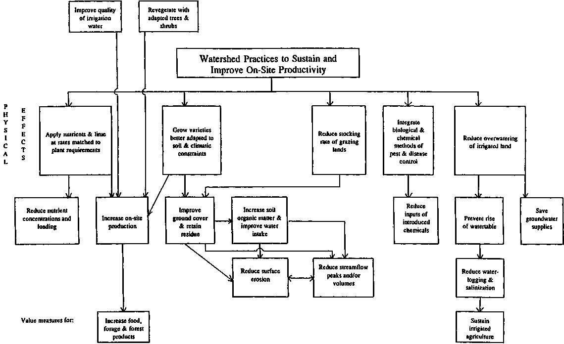
Production outputs are the first line. These are the main, but only partial, test of the success of agricultural intensification. A main objective of research and extension is to increase yields, or at the very least to prevent declines such as have been recorded in Africa (Table 1). The tools available for this are set out schematically in Figure 3. Different boxes in these schemes will be applicable to different parts of the idealised watershed in Figure 2.
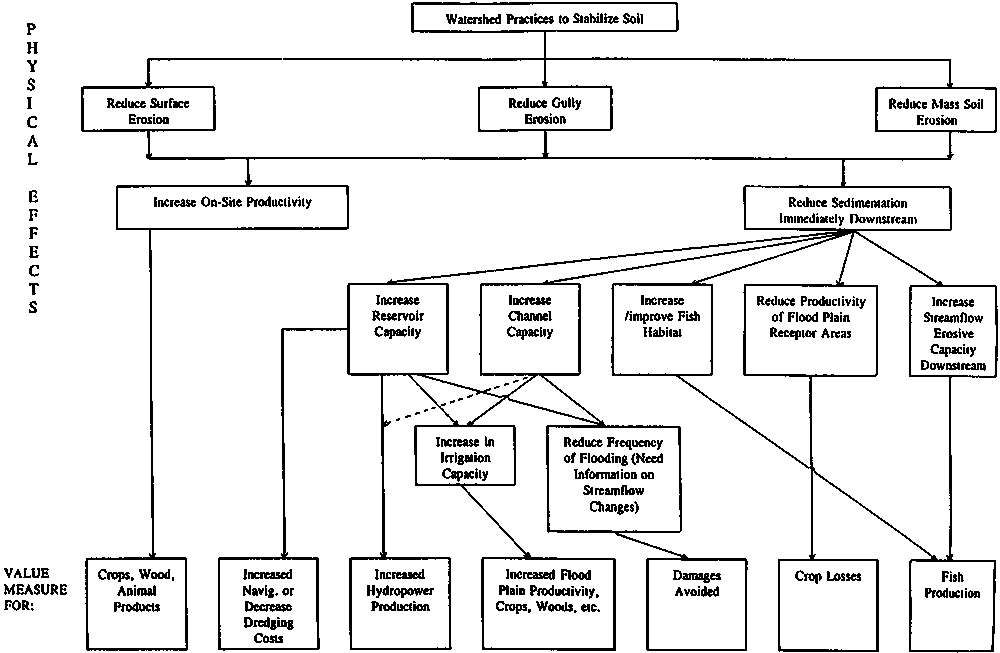
The remaining part of the test of success is to minimise the other three lines. The consequences of water-erosive processes are schematically presented in Figure 4. Prevention of soil loss can be done by a number of well-known techniques, which need selection of the most appropriate, and adaptation to local conditions. The impacts of erosion are felt on-site, both where soil is lost and where it is deposited, and in other land use units where silt is deposited, on fields, in watercourses and in dams.
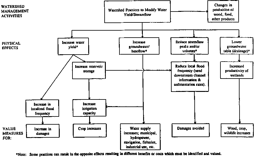
The third line represents water flow rate and flow pattern. Apart from major interventions such as dams and channel alterations, water flow can be modified by altering the rate at which water reaches the river and affects the hydrograph. This can be done by altering land use (for example, from forestry to grassland) or by changing the "first partition point," between infiltration and runoff by altering the soil surface properties with cultivation, mulches, SOM level, water ponding or others. The benefits of this better control are set out in Figure 5.
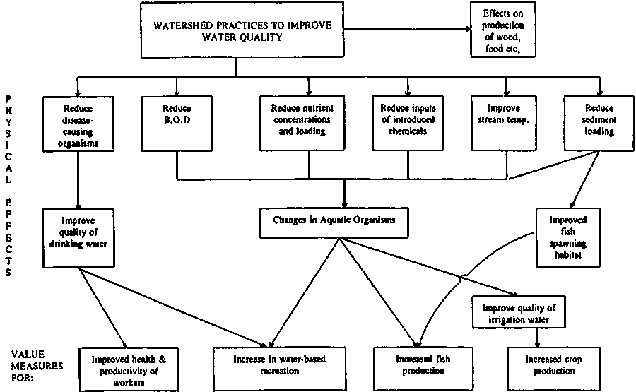
Water quality is the fourth line. This can be controlled by minimising the use of fertilisers and agrochemicals, controlling feed lots, stopping large inputs of organic material to watercourses, preventing accidental spillages and managing irrigation systems to control saline drainage water. The benefits of successful control for downstream land users are in Figure 6.
In fact, water quality and quantity are closely linked. In a simple case, the concentration peak that travels downstream in a river after a pollution incident will be dispersed at a rate that depends upon the volume of water, its flow pattern and the river's course. All these processes must therefore be seen as a network of interactions. This complexity is the main challenge of integrated watershed work, and any intervention with a single objective raises the danger of unforeseen problems. Sometimes the results are totally unexpected, as with the damage suffered by Mediterranean fisheries when the silt load of the Nile was reduced by the building of the Aswan dam.
The above discussion has focused on the agricultural and forestry land uses. This idealised watershed will almost certainly have cities and towns. These will all have demands for water of acceptable purity, for domestic and industrial use. The waste systems will also produce sewage, which has to be purified, and the effluent fed back into the river - these are potential point sources of heavy pollution. They are probably even more likely than agricultural pollution to cause eutrophication, excessive algal growth and possible anaerobiosis in the rivers and lakes. The management of surface waters in these cases is itself a difficult and professionally challenging task (Ryding and Rast, 1989). Furthermore, the cities will contain soils, and the management and use of urban soils is a growing issue (Bullock and Gregory, 1991).
Figure 2: An Idealised Catchment
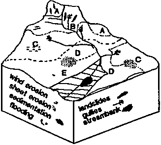
Source: Perrens and Trustrum (1984)
The value and applications of NRM research on a world scale are incontrovertible. They range from making land agriculturally useful by detecting specific deficiencies, for example copper in Australian soils, to the understanding of hydrology and soil physics that allow irrigation schemes to be designed. In agricultural terms, NRM and production research overlap, and often fuse. This research over decades has built up a considerable knowledge bank on soil management, erosion control, river management and groundwater use, and much applied and adaptive research in the less-developed world has drawn directly on this. In some important cases this adaptation has been extremely successful, as is represented by the Green Revolution, in which improvements in germplasm, plant nutrition, plant protection and water supply all had their part.
It is noted in the main report of this paper that advances in application often do not result immediately from current research, but that all of them draw upon the bank of knowledge that has been stored up by previous research. This is quite appropriate for strategic research, because it is intended, by definition, to produce knowledge of the underpinning or cutting-edge type, rather than immediate solutions. It is more a cause for concern if applied, or especially if adaptive research is not used. However, there do appear to be large areas where NRM research results have simply not been used. It is usual to blame this on the proposition that the proposed solution is socioeconomically difficult to apply, or simply unprofitable, or that conditions in these areas are so different from those elsewhere that the knowledge bank cannot be applied, or that the solutions it provides prove unreliable or partial.
Where the socioeconomic conditions are favourable, so that farmers can get a sufficient cash return for their work, there are successes, such as the well known Machakos work (Tiffin et al., 1993). A number of small-scale pump- or gravity-fed irrigation schemes in Mali and Kenya have also been successful (Muchena, private communication). These depended variously on sound characterisation of the environment, and on participatory approaches with farmers and local authorities. The watershed work in East Africa in the 1950s and 1960s provided essential underpinning information concerning land uses, such as that, in particular locations, indigenous forest could be replaced by softwood or tea plantations without affecting the water yield of the watersheds, or damaging the soil. The level of erosion protection that was necessary for cultivation, and the acceptable level of grazing, was specified. Where these results were applied and followed, they were successful, but elsewhere they were ignored.
A recent update on the situation in Kenya (Pretty et al., 1995) shows how successful the catchment approach has been when consistently applied in a fully participatory way, as is also reported in Section. 4.5 This emphasizes how often major programmes in soil conservation have not been followed through, and have been allowed to deteriorate when the farmers who should benefit are not convinced of the value of the work and of their own role. It is clear that sound technology and biophysical analysis can be successfully applied when the social conditions are right. As an example of this success, the imports of maize to the Machakos district have decreased by more than half on a per capita basis over the period since 1945 during which the population has increased threefold. A somewhat similar report is given by Manu et al., (1994) for a watershed in the Niger. Again simple but well-adapted and basically sound technology worked very well when applied by enthusiastic and convinced farmers, and produced much improved crops. The project did however demonstrate that external nutrient inputs were essential to sustain yields, in line with the discussion in this paper. Similarly, the Parana Rural Project of the World Bank has used tested and adapted technology on 1150 microcatchments, with good results for soil and water conservation (Couto, private communication).
An excellent example of a "catchment" problem at a totally different scale of the whole of Egypt is discussed by Biswas (1995). The uses of land and water resources are inextricable interrelated, and most of the agricultural problems relate to water quantity and quality, and the overall sustainability of the system is dependent on these. Scientific water management is here essential.
There are clearly many situations where existing strategic knowledge can be and has been used for applied and adaptive research, and has produced biophysically successful results. Much of the work in applying this basic information can probably be described as adaptive research. However, it is rarely a question of going into the field and making measurements according to a standard technique and applying solutions from a textbook. Professional scientific understanding, and the ability to modify procedures and technologies according to the properties of a particular area, are essential for this type of work.
Figure 3: Priorities related to sustaining or increasing on-site productivity
Figure 4: Priorities related to increasing soil stability (from Gregersen et al., 1987).
Where existing methods have not been applied it is logical to call for simpler, cheaper and easier methods, and research should certainly be directed towards discovering these. However, there is a point beyond which it is unreasonable to expect cheaper and easier solutions, if the biophysical situation is in fact technically difficult and complex. If better or cheaper biophysical solutions are not readily provided, it may be possible to use socioeconomic interventions that make the existing lowest-cost biophysical solution acceptable.
If much-superior biophysical solutions are not available, policy interventions that modify the socioeconomic circumstances may still be possible, so that modest low-cost biophysical solutions become more acceptable. It is difficult to assess exactly where research stands at present on these issues, and it is for this reason that this paper suggests that a stock-taking by CGIAR would be useful. As is clear from 4.5, biophysical research alone can rarely solve problems in the real world, but it is very difficult to solve any of them if the biophysical basis is not available and correct.
To close this short review of problems, reference is made to an analysis of relevant World Bank project experience (OED 1989). From recent audits of a set of 335 agriculture and forestry projects, 8% had adverse results involving soil erosion or salinisation. Of the various adverse results, shortfalls in performance were attributed to one or more of inter alia inadequate knowledge of: physical conditions (42%); techniques (28%) and; social institutions (12%). The stakes for developmental interventions are large indeed, and the returns to improving knowledge of NRM phenomena are likely to be great.
The economic, social, policy and public management and administrative dimensions of the topics outlined in section 4.3 are naturally wide-ranging and are in the research agenda of many concerned agencies, governmental and non-governmental. Within the CGIAR System, the broadest programme of work is that of IFPRI on evaluating trends in tropical land degradation and improvement. This work is being given scientific and empirical underpinning through the new collaborative links between IFPRI and other CGIAR Centres active in land research. As IIMI takes on the new directions promised by its Director General designate, its research links to IFPRI on water management will also strengthen. The present status of CGIAR work is taken up in the review of this Study prepared by the TAC Secretariat (Document No: SDR/TAC:IAR/95/10), and is only touched upon in section 5. The present section sets the scene for considering socioeconomic and policy and public management research work by posing and answering three broad questions, which in the event are especially related to management.
Question I: What issues can best be addressed at the international level?
Natural resource management issues are primarily national and local ones. They can usefully be studied comparatively and cross-nationally, but they are invariably quite political, or have political implications. Thus, solutions need to be developed quite inductively (in a learning process mode, as Korten (1980) has proposed) and in accord with national and local traditions, cultures and values, not to mention their respective and often unique biophysical conditions.
This said, international institutions can play a valuable role in this area, affecting the climate of opinion through their research and publications, and improving analysis through the development of concepts, methods and measures. The first is probably the most important, though it is hardest to plan or to prove.
In the area of irrigation water management, for example, a significant movement has been evident toward new, more participatory, more efficient and more effective management systems over the past 20 years (Meinzen-Dick et al., 1994). This was initiated with Ford Foundation support in the Philippines, India, Nepal and Indonesia; it was supported by donors, first USAID in Sri Lanka, Indonesia and Nepal, and then the World Bank in the Philippines and elsewhere (Korten and Siy, 1988; Uphoff, 1992). This effort is presently being supported by IIMI under the rubric of Turnover. In the course of this period, some successful examples of participatory irrigation management were initiated and documented. Cross-national comparisons were made, supported by FAO, Asian Development Bank and other institutions, in addition to those named above.
Over time, decision-makers and state sector managers in less-developed countries have confronted a growing body of evidence and analysis that pointed the way to more effective and beneficial irrigation management (Uphoff 1986a; Singh 1991; Parlin and Lusk 1991). New assumptions have come to be widely shared about the feasibility and desirability of adopting less bureaucratic approaches.
With regard to watershed management, similar in this respect to forest management, there is a long tradition of technocratic perspectives and control. Indeed, the concept and strategy of bureaucratic reorientation (Korten and Uphoff, 1982) was prompted by experience with forest management agencies that was similar to what was observed with irrigation departments in Asian countries. A similar progression, though slower, has also been apparent in the forestry area, as forest agencies in many places have come to recognise that the resources they are responsible for can be more beneficially and effectively managed in cooperation with persons living in and around forested areas (Cernea, 1989; Arnold and Dewees, 1995). A similar pattern has occurred in terms of rangeland management, recognising that user participation is the key to success, as is increasingly well documented, for instance, in ILCA/ILRI publications and its African pastoral research programmes, and in the ICARDA/IFPRI work in the Middle East steppes.
Watershed management is now receiving similar attention, and lessons from other NRM areas are being brought into this domain mutatis mutandis - and sometimes not in this way, being simply transferred from other domains, which is a prescription for difficulties, since different areas as well as different resources require management systems that are adapted to the particular biophysical and socioeconomic circumstances. There is more interest now in participatory approaches than there was some ten years ago (e.g., Sample 1993; World Bank 1995), and this reflects in part the actions of international institutions and researchers who have raised issues and examined alternatives.
Certain important issues in NRM such as land tenure can be identified as candidates that international institutions should study and provide advice on. But it is hard to say that these can be "best" addressed at the international level unless it is clear that they will not be (adequately) tackled at national and sub-national levels, so the international level only becomes the best by default. In fact, the research community is international, and every encouragement should be given to researchers around the world, in their respective national and local settings, to try to illuminate important issues such as land tenure and its impact on sustainable NRM. But this is not necessarily something done "at the international level." As is discussed in section 5.5, international institutions could well contribute to better NRM by supporting networks of national and local researchers. But this can include research done at and by CGIAR Centres in the "classic" CGIAR mode.
Question II: What have been the successes in this area, and why?
Resource management issues naturally differ from country to country but, even where they are similar, performance varies greatly because of significant institutional differences. Attempts to generalise about successes or otherwise are thus fraught with difficulties, but must be addressed to help to define roles for the various potential actors, local, national, and international. Needless to say, there are many actors who have explored their possible roles, although the deliberations are not always documented in the public domain. These include planning documents for concerned NGOs, institutional development documents for governments considering, for instance, how best to set up environmental protection agencies, and so on. One of the players, until recently a somewhat coy one in this area, is the World Bank. It was long and persuasively argued that the Bank had neither the mandate to intervene in matters so deeply rooted in national culture and policies, nor the technical and financial clout to make sufficient a difference. But all this changed radically in the late 1980s as signalled, for instance, by the creation of its Environment Department and counterpart regional environmental operational units. In the process of entering upon these new institutional arrangements, the Bank took various steps to consider its position in resource-management related lending, which has now become strongly oriented to environmental interventions. This included consideration of soil-conservation interventions and policies (Anderson and Thampapillai, 1990; Sfeir-Younis and Dragun, 1993) and it (through its Operations Evaluation Department (OED)) undertook a review of investment experiences pertaining to renewable resource management in agriculture (OED 1989). This report includes a dozen country case studies, as well as syntheses of cogent issues, and the work has guided a proliferation of environmentally oriented lending operations that now occupy a significant part of the Bank's portfolio, in agriculture and other sectors, and (reflecting a persistent theme brought out in the studies) feature strong attention to ensuring participatory approaches, recently enshrined in the World Bank (1995) Participation Sourcebook.
Rather than review this OED review, the question presently posed can be answered indicatively, and still more satisfactorily than could the first question be, by discussing three quite different examples of success in watershed management. These come from India, Sri Lanka and Haiti, and offer useful guidance. None of these cases is as "old" as would be ideal before concluding that they are "successful" but they are still instructive. A number of very short descriptions of innovative watershed management programmes in Africa, Asia and Latin America are available in Hinchcliffe et al. (1995), but they are too cursory to present and analyze here. The common denominator in the cases reported there is participatory management. Readers familiar with such case examples might choose to skip to Question III below.
RAJASTHAN, INDIA In 1991, the Government of the Indian state of Rajasthan created a new multidisciplinary department of Watershed Development and Soil Conservation, building on the Soil Conservation wing of the Agriculture Department and drawing in staff then from other departments. The programme had substantial funding available from the central government's National Watershed Development Programme for Rainfed Areas and a World Bank-funded Integrated Watershed Development Project.
Within two years, it was carrying out conservation and development work on over 100,000 ha in over 250 locations (Krishna, 1995). It emphasised local participation through User Committees that were facilitated by department staff. Rules and procedures for snaring costs and benefits among local residents, and between them and the government agency, were worked out consultatively, with different formulas adopted in different locations. In both 1993 and 1994, the programme was awarded a Certificate of Merit from the National Productivity Council of the Government of India for its development of appropriate technology and for its high degree of community participation.
A very decentralised approach was taken, with the delimitation of 250 watersheds averaging about 4,000 ha each. A multi-disciplinary (multi-departmental) team was assigned to each watershed, to work with the villagers residing therein. Great encouragement was given to be experimental and to innovate, with the result that a visiting GOI official spoke of "a widespread unleashing of the creative talent of field staff." (Krishna, 1995). The programme expanded rapidly, to cover ten times the area previously served by soil conservation schemes, and this was possible with staff reorientation and enthusiasm, and with village response.
Krishna considers as the main factors in the rapid success: (a) the experimental and adaptive approach taken to technological innovation, (b) the rapidly and strongly enforced administrative coordination, and social organisation among government agencies, and (c) the attention and support given to social organisation, i.e., to user and community participation. Whether the programme will retain its operational and philosophic thrust without his leadership is something yet to be assessed. But this case has shown what even a bureaucracy known to be rather lethargic and a set of communities known to be quite traditional and isolated can achieve in short order.
SCOR PROJECT, SRI LANKA In 1990, the International Irrigation Management Institute was contracted by USAID to design a new kind of NRM project. USAID's previous support of a water management project focused on the Gal Oya irrigation system (1979-85) had shown good results by engaging water users in a multi-tiered structure of organisation, starting at the field channel level and extending upwards. The largest and one of the most run-down irrigation systems in the country had become one of the best managed within a few years, doubling the efficiency of water use (Uphoff, 1992).
After extending this participatory irrigation approach to four more major irrigation schemes (in Polonnaruwa district) through a follow-on project (1986-91), USAID and IIMI were interested in tackling the resource management problems of whole watersheds in a participatory manner, to see how far the methods developed inductively, i.e., in a learning process mode, in Gal Oya could be extended beyond irrigation.
Two whole watersheds were chosen as pilots for the Shared Control of Natural Resources, known as SCOR: Huruluwewa in the North Central Province, and Nilwala in the Southern Province. Each had a major irrigation system downstream that would be jeopardised in the long run if shifting cultivation continued in the upper catchment area and accelerated the deforestation and erosion already evident there. Sub-watersheds in the range of 75 to 600 ha were identified (similar in scale to those in Rajasthan). The project was not implemented by a single department as in Rajasthan. Rather, IIMI recruited interdisciplinary teams of professionals with a variety of skills and backgrounds, but all committed to a participatory approach (SCOR 1995).
SCOR combined participatory assessments of present land and water use patterns, capabilities of resource user groups and support services, socioeconomic status, status of resource degradation, and potential for development, with more sophisticated geographic information system (GIS) technology. Persons were recruited, trained and deployed in the field as "catalysts" (as in Gal Oya) to work with communities to promote social organisation. Here they worked not just with irrigation water users but also with upstream resource users.
To assess progress and success, the project is monitoring sediment concentration and sediment load in the streams and rivers of the respective watersheds, changes in soil fertility and soil loss, biomass, water quality, and rainfall runoff and infiltration; water use efficiency in agricultural activities, factor productivity and profitability, cropping intensity, and cost reduction/value added; and effects of land (including common property) covered by group activities in terms of production and protection, value of investments made by user groups, number and type of commercial activities undertaken by groups, number of policy and procedure changes associated with project and user activities, and returns to shared control of land and water resources. The strategy is characterised as seeking an effective balance and blend of technologies, organisations and resources.
This is quite a dramatic step forward toward integrated management of soil and water resources. While it is operating on a smaller scale than the Rajasthan case, it is similarly interesting because of its promotion of commercial enterprises that are intended to give greater value to natural resources in a way that should create incentives for their conservation, and because it is linking upstream and downstream resource users into a common forum to assess and decide on all forms of NRM. Implementation is involving all relevant government agencies and the several levels of local government that have jurisdiction within the watersheds, so that the new people's organisations will have understanding and support from public-sector agencies.
MAISSADE WATERSHEDS, HAITI Beginning in 1989, staff of Save the Children, an international NGO, began meeting with landowners in 22 small, multi-owner watersheds (averaging 9 ha in area) in the central plateau of this impoverished country. The region was quite hilly (average 12 percent slope), and soil erosion was contributing to steadily declining agricultural yields.
Although Haiti is not known for collective action, a majority of the landowners were members of informal, self-organised and self-governing farmer co-operatives known as groupman (with 8 members on average). The average size of holding was 2.5 ha, spread in usually three separate parcels. A survey showed that the average watershed in the area had 9 agricultural parcels with 9 different landowners (White and Runge 1995).
Transboundary erosion was common in these watersheds and could hardly be avoided where the soil infiltration rate was low and there were few if any soil conservation structures. All but the topmost farmers both lost and received soil through erosion, creating a perverse kind of interdependence. Downhill farmers in principle could benefit, but the rapid runoff itself caused problems, and the spread of gully erosion as well as sheet erosion was a threat to most farmers on these hillsides. (See also White, 1992b; and White and Quinn, 1992, on the watershed programme.)
State efforts to curb erosion had proved ineffective, according to Murray (1979). Yet this NGO programme proved quite successful in mobilising local voluntary labour to construct checkdams, working with rural residents on the basis of informal cooperative action that they were familiar with (groupman). Within two years, 10 of the principal ravines had been treated, with partial treatment of another seven, while five remained without much soil conservation accomplished.
A total of 590 checkdams were constructed by the groups, averaging 27 dams per watershed, which were estimated to retain an average of 39 t/ha/y of soil (White and Jickling 1992). The amount of labour mobilised on a voluntary basis for soil conservation was impressive: 32 person-days per year from landowners. Perhaps more impressive was the voluntary contribution of 18 person-days per year from persons who did not own land in the watershed. Building on traditions of cooperation and mutual self-help, there was a substantial community effort to counter the effects of erosion that were visibly eating up future production possibilities.
White and Runge (1994) report that project support of the watershed activity ceased after two years "due to political instability and government repression of peasant groups." Yet despite this adverse climate, when White carried out a survey two years after the halt in support he found that groups remained active in 12 of the 22 watersheds (White and Runge, 1995).
The Haiti case is considered a success not because of the large scale of operation as in Rajasthan, or the innovative institutional development as in Sri Lanka, but because (a) it operated under very adverse sociopolitical conditions and in a physical environment where soil conservation and watershed protection was so urgently needed, and (b) it showed possibilities for collective action that had hardly been considered possible by most social scientists and most policy-makers. Extremely poor and isolated rural people were willing to invest labour and organisational effort to preserve as best they could their agricultural possibilities for the future.
Question III: What are the ingredients for success?
Discussion of this question could be long indeed, mirroring such 200-odd page treatments such as that of OED (1989) but, for brevity, the ingredients are simply listed here with only minimal discussion.
· All three of the above case examples built upon the foundation of participatory local organisation. These were formally recognised in two cases and left quite informal in the third, partly because rural organisations were at some risk under Haitian conditions in the late 1980s. In all three cases, rural people when approached with respect and a spirit of cooperation, rather than of technocratic management and control, responded positively.· How rural communities were approached was important in all three cases. Specially trained catalysts were used in Sri Lanka, building on some years of experience with this approach there, whereas NGO staff with a non-bureaucratic orientation were used in Haiti. It is impressive that, in the Rajasthan case, government personnel were somehow persuaded to adopt unofficious manners and to engage rural communities in a fairly collegial manner.
· The outside agencies took a firmly interdisciplinary approach and also stressed inter-departmental coordination and cooperation.
· All three programmes worked in a learning process mode, with some advance plans but a willingness to adapt and change plans as experience provided new insights and presented new challenges. It is unlikely that a "blueprint" approach can devise a successful strategy for watershed management/soil conservation under many conditions (cf. Critchley et al., 1992).
· The programmes gave attention to appropriate technologies, being very experimental and taking local people's advice and ideas into account. Especially when dealing with soil and water, as well as trees and grasses, one cannot violate technical requirements and limitations. But it was particularly important to devise an appropriate "fit" between the technologies being promoted and the organisational channels developed for management.
· The method of diffusion of innovation was more horizontal than vertical, with provision made for farmers and communities to visit each other and exchange experience. While it true that "seeing is believing," it is also very persuasive to learn about success from people "like yourself." Observation tours were important in all three programmes.
· It was helpful that in Haiti, the programme could build on indigenous 4 institutions, and this seems generally a successful approach. However, in the other two cases, it was possible to establish new bodies, user committees, groups or organisations.
· Such successes are not achieved with average or typical persons in top roles. The proof of outstanding leadership is that other persons within the programme perform at levels above and beyond what they would do with others in top roles.
· A further element going along with this preceding point is bureaucratic reorientation that redirects the thinking and efforts of the implementing organisation (Korten and Uphoff, 1982; Uphoff, 1992). This is most important where a government agency is responsible for carrying out the watershed management programme.
Other comparisons and observations could be made, but these points sketch a picture of the kind of strategy that is most likely to promote effective public management and to help develop institutional capacities at various levels to achieve better utilisation and protection of soil and water resources.
International agencies can attempt to support processes of bureaucratic reorientation, for example, or can lobby for the right of free association where this is denied or constrained, and its lack inhibits effective user groups. But such issues are intrinsically political and thus do not sit readily in the portfolio of activities of centres so studiously and jealously apolitical as those of the CGIAR. A more effective approach is the indirect one of building up a broadly-shared consensus that supports the kind of watershed management strategies that effectively involve resource users in decision making and implementation.