Key results of the GIS analyses are presented in this section. The results are classified into the following categories: VS (very suitable), S (suitable), MS (marginally suitable), and US (unsuitable). In order to provide a comprehensive analysis, the results are presented separately by country and continental levels. Furthermore, in order to follow the structure of the preceding methods section, results have been partitioned by fish farming system and by fish species. In other words, factors important for the development and operation of fish farms are evaluated separately from the crops/y results. This results layout is similar to that used by Kapetsky and Nath(1997), and allows examination of the estimates of the quality of land for fish farming in ponds irrespective of the species used. Conversely, the same rationale applies for a separate evaluation of the crops/y potential of each fish species. Finally, the combined models and the overall coincidence among them for the three fish species are also considered separately. Procedures for the statistical results and grid outputs are available in Appendix 8.11 and 8.12 respectively.
Result descriptions include 49 African countries. However, for simplicity and clarity, only those countries where inland fish farming is most favourable are presented in all histograms below (i.e. 30 are presented).
Differences in thresholds, models and data used between the previous African study (Kapetsky, 1994) and the present one do not allow direct comparison of the factors used in the evaluation. Nevertheless, it was possible to make a general comparison among submodels, because they were developed to meet the same objectives (e.g. to identify areas where water was most available).
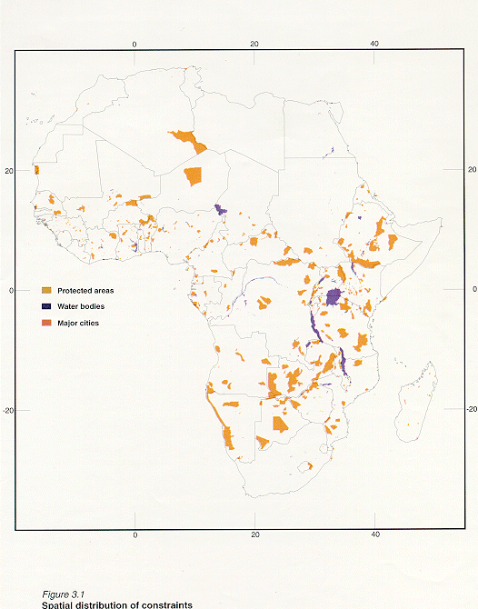
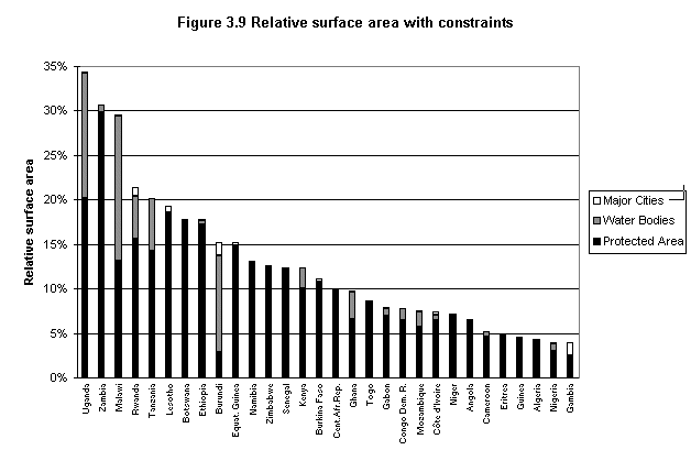
Constraints were identified in all African countries. The largest constraint area is occupied by the protected areas, about 6 % of continental Africa (Table 3.1). These are distributed across Africa, with the largest surface areas in South-eastern Africa, and with the smallest surface areas located west and north of the equator (Figure 3.1).
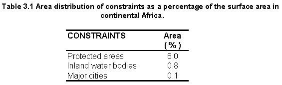
Large inland water bodies occupy about 0.8% of Africa, and are distributed across the entire continent. However, water bodies with the largest surface area occur in South-eastern Africa.
Major cities take up only 0.1% and are distributed across the continent. The highest density of major cities is in the Northwest part of Africa.
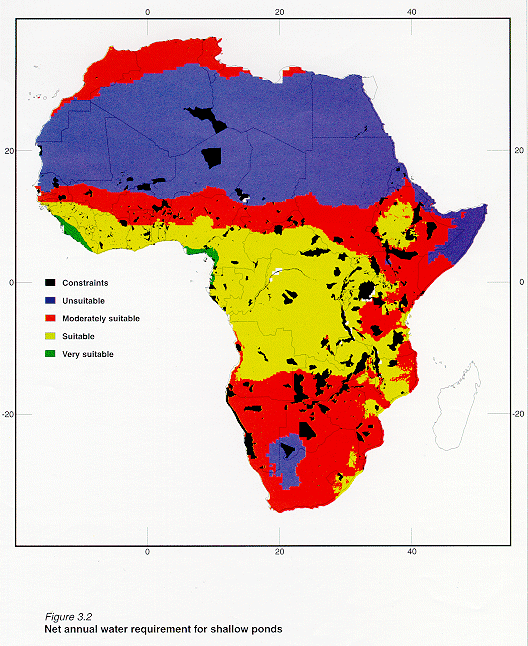
Water requirement is the most limiting of all submodels at the very suitable level, with about 0.6% of the African surface being classified as VS; however an additional 27% is rated S (Table 3.2). The coastal fringes of NW Africa and Central Africa have the highest potential for pond water supply (Figure 3.2). This is particularly significant since water requirement was the most important submodel in the small-scale model and was ranked second in importance for the commercial model. The spatial distribution of water availability is similar to that in the previous African study (Kapetsky, 1994).
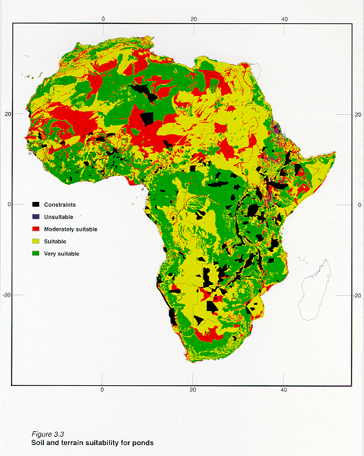
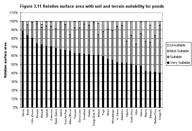
Except for cities and roads, soils are the most limiting factor at the VS level (about 1.6%) of the African surface (Table 3.3), but 42.5% of the surface area rates suitable. Slope is the least limiting factor with about 93% of the African surface area being rated as VS (Table 3.3). The combination of soils and slopes (soil and terrain submodel) suggests that about 40% is very suitable and 41% suitable (Table 3.2). Very suitable soils and terrain are distributed throughout continental Africa and only a small surface area (about 0.7%) was found to be unsuitable (Figure 3.3). The overall soils results are comparable to the previous African study (Kapetsky, 1994; Table 3.2).
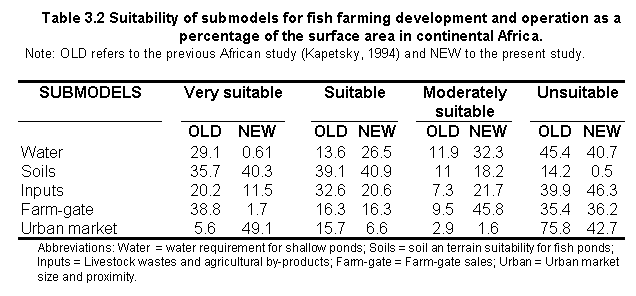
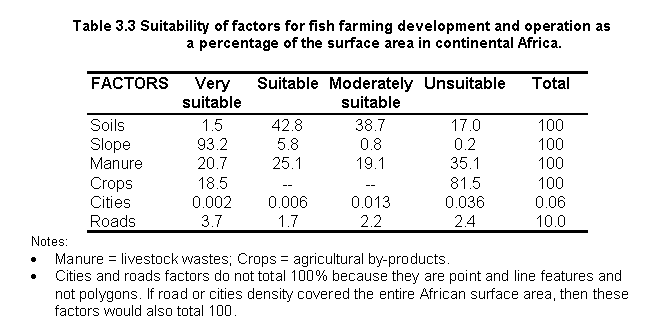
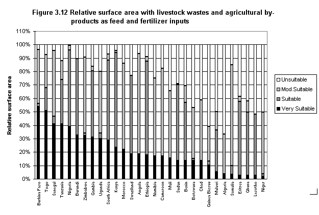
21% of the surface area in Africa rates VS in terms of livestock waste potential; an additional 25% rates S (Table 3.3). Cropland areas that were classified as VS total about 19% of the African surface area (Table 3.3) and occur in broad bands across the continent, particularly throughout a large part of Southeast Africa. Combining manure together with the crops resulted in 12% and 21% of the area being respectively classified as VS and S (Table 3.2). Clearly, the spatial distribution of the very suitable areas in this submodel was greatly influenced by the crops distribution (Figure 3.4). Despite the percentage area differences between the current study and the previous one (Kapetsky, 1994; Table 3.2) it was confirmed that the very suitable areas in both studies were similar.
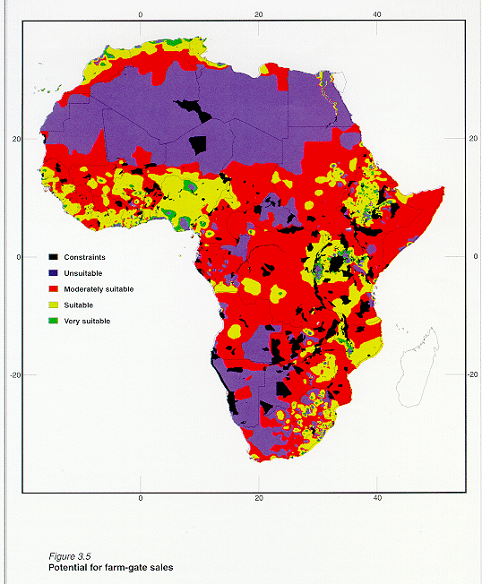
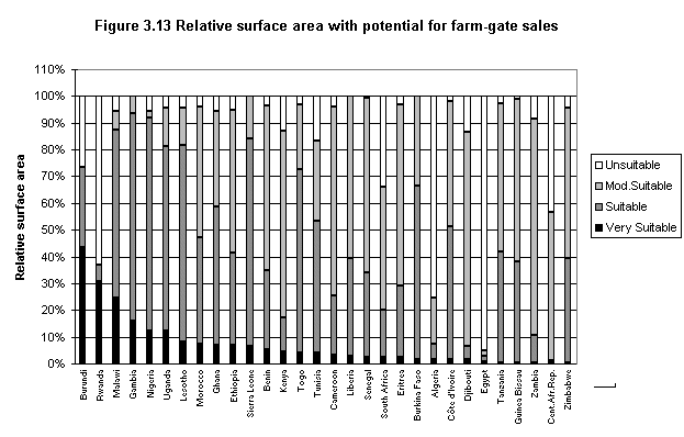
Farm-gate sales is the second most limiting submodel at the VS level, with only 1.7% of the area capable of supporting markets for farm-gate sales; further only an additional 16% rates suitable (Table 3.2). Areas with very suitable markets are patchily distributed in Morocco, West Africa, Central Africa south of the equator and South-eastern Africa (Figure 3.5). Large differences were found for the farm-gate sales factor between the present and the previous study except for areas classified as suitable (Table 3.2).
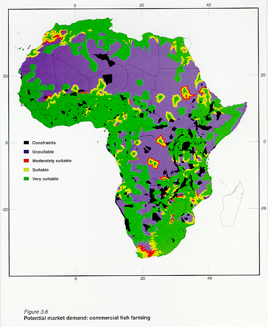
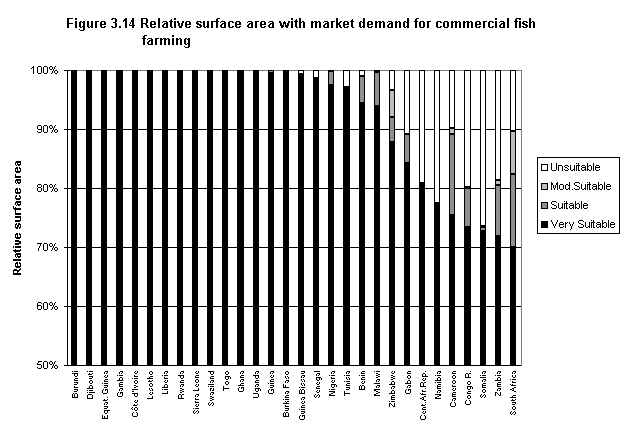
Most major cities in Africa are ranked as unsuitable (Table 3.3) with regard to supporting a high market potential. However, this is not the case for roads, because a highest percentage of the surface area was ranked VS (Table 3.3). When these two factors are combined to assess the urban market potential, results suggest that this submodel was the least limiting, with 49% of the African surface area being rated VS (Table 3.2). In other words, 49% of the continent is within reasonable proximity of large urban centres that could be important for commercial fish farming development. As was the case with farm-gate sales, this submodel also has a patchy distribution attributable to the spatial distribution of the major cities and roads (Figure 3.6). Significant differences were found between the present study and the previous one, both in terms of area and spatial distribution (Table 3.2).
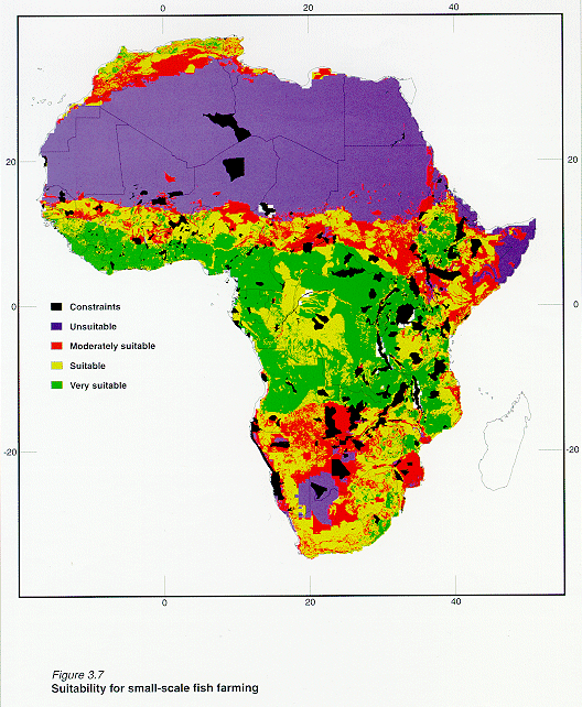
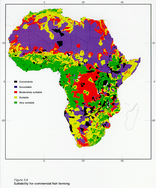
Results from the farming system models (Table 3.4) show that both small-scale and commercial models present similar areal distributions (i.e. in terms of percentages) for each of the four suitability classes. Both models show that very suitable sites occur in about 23% of the surface area across the continent, particularly in many parts of Southeast Africa; however, there are some clear spatial distribution differences (Figure 3.7 and figure 3.8). This is because the small-scale model is clearly influenced by the importance of the water requirement submodel, whereas the commercial model is influenced by the urban market size and proximity submodel. The latter influence is evident in the patchy distribution of some suitable areas.
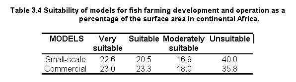
In comparison to the results obtained herein, Kapetsky (1994) found that 31% of the African surface contains areas that are apt for warm-water fish farming at a small-scale level and 13% at a commercial level. For both studies, very suitable sites occur across Africa, north and south of the equator. However, because the previous study was limited to warm water fish species (Nile tilapia and African catfish), it did not show any fish farming potential in Morocco and Southeastern Africa, unlike the current study.
Uganda, Zambia and Malawi stand out as countries with the largest extent of constraint areas (Figure 3.1 and figure 3.9). Zambia has the highest portion of protected areas (about 30% of its surface; Figure 3.9). Three countries (Malawi, Uganda and Burundi) have about 10 - 16 % of their areas containing large inland water bodies. Finally, Gambia, Burundi and Rwanda are countries with the highest concentration of major cities.
Water requirement
Only one country, Sierra Leone, has a large area (about 60%) that is VS for water requirement and only 6 other countries score VS for 3 to 40% of their area (Figure 3.2 and figure 3.10). However, there are 25 countries that have 25% or more of their areas classified as S. Thirteen countries have no areas that score VS and relatively small areas that score S to MS for water requirement. In this regard, Egypt and Mauritania stand out as countries with 100% of their area classified as US, implying that water availability is likely to be a serious constraint in these countries (Figure 3.10).
Soil and terrain suitability for ponds
24 countries score VS (50% or more of their area) and 16 others score VS (25-50%) for this category of factors (Figure 3.3 and figure 3.11). Only five countries(Sudan, Egypt, Botswana, Chad and Djibouti) have very small surface areas that score VS (less than 15%; Figure 3.11).
Inputs
Burkina Faso and Togo are particularly favoured for inputs (Figure 3.4) and have about 50% of their area scored as VS. Eight additional countries have areas from 30 to 40% that score VS (Figure 3.12). Twenty-one countries have 25% or more of their areas that score S. However, 40 countries possess areas (10% or more) where inputs are potentially insufficient. Libya and West Sahara stand out as having nearly 100% of their area scored as US.
Farm-gate sales
Farm-gate sales seem to be limiting at the VS level (Figure 3.5), with only Burundi having 40% of its national area scored as VS (Figure 3.13). Only five countries (Rwanda, Malawi, Gambia, Nigeria and Uganda) have from 10 - 31% or more of their area scored as VS (Figure 3.13). Nevertheless, 24 countries have 25% or more of their areas scored as S. Egypt, Libya and West Sahara are notably lacking in market opportunities for farmed fish .
Urban market size and proximity
A large number of countries seem to be within reasonable proximity to large urban centres where there could be important markets for commercial fish farming development (Figure 3.6). 12 countries have 100% and eight additional countries have nearly 100% of their national areas scored VS for this factor (Figure 3.14). Most of the other countries have between 15 to 90% of their area scored as VS. Sudan was the only country with less than 15% of its surface area categorized as VS (Figure 3.14).
Small-scale model
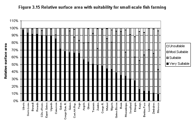
Of the 49 countries included in this study, 42 possess at least some land scored as VS (Figure 3.7). Among these, 16 countries that have 50-97% of their areas scored as VS. Liberia, Sierra Leone, Burundi, Rwanda and C�te d'Ivoire stand out as the top five countries within this category (Figure 3.15). In addition, nine countries have 30-50% scored as VS and another 22 countries have 25% or more of their areas scored as S (Figure 3.15).
Commercial model
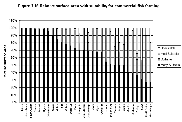
In all, 46 countries have at least some of their land scored as VS (Figure 3.8). Among these, 21 countries have between 50% and 99% of their areas classified as VS. The top six countries for the VS category were: Liberia, Sierra Leone, Equatorial Guinea, Rwanda, Burundi and Uganda (Figure 3.16). Nine countries were found to have 30-50% scored as VS and another 19 have 25% or more of their areas scored as S (Figure 3.16).
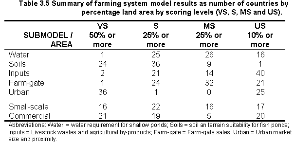
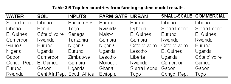
Table 3.5 summarizes results of the farming system models, in terms of the number of countries with corresponding percentages of land area in the different suitability levels. Table 3.6 lists the top ten countries (in rank order) that were found to possess the highest potential in terms of the quality of land for fish farming in ponds irrespective of the species used.
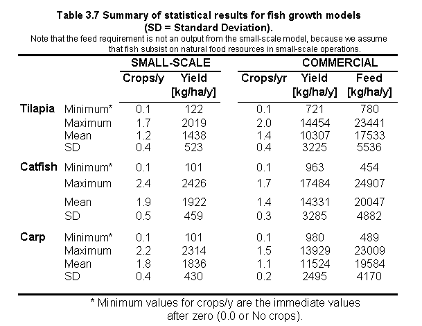
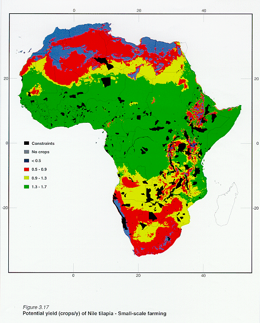
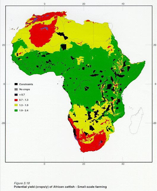
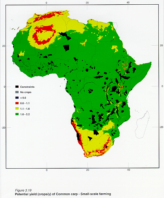
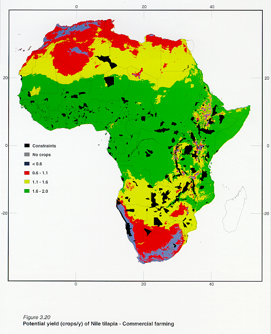
Statistical results of the fish growth models are presented for reference in Table 3.7. However, the primary output from the growth model that is of interest in the current study is the yield (in crops/y) for the three different fish species in different regions. Hence, these outputs are discussed below for each of the scenarios used to define commercial and small-scale aquaculture operations. For simplicity, crops/y results are separated into quarter (Q) parts of the ranges obtained for small-scale and commercial operations.
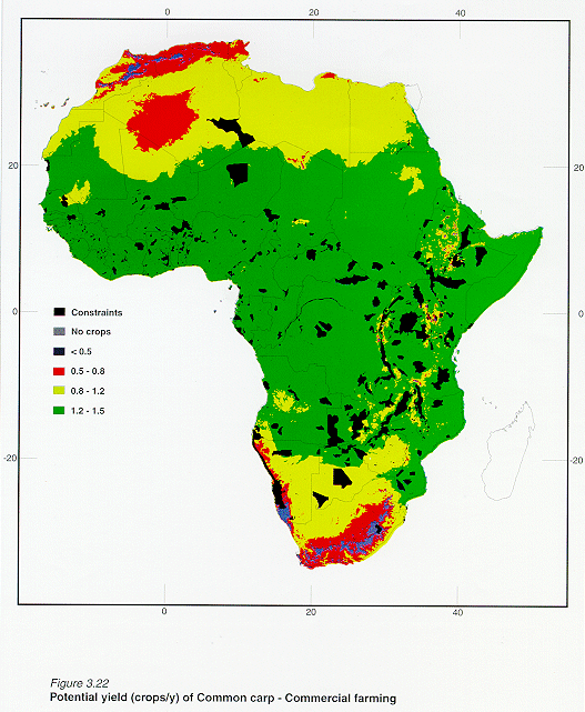
Over 50% of Africa has land areas with 1stQ yields for the three fish species and for both types of farming systems. The largest surface areas scored in the 1stQ yield range were found for Common carp and African catfish (Table 3.8). For small-scale farming, Common carp stands out as having the largest surface area scored in this yield range (about 76%) and for commercial farming African catfish and Common carp have similar surface areas (70 and 66% respectively).
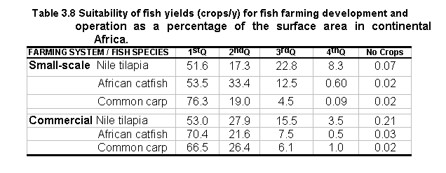
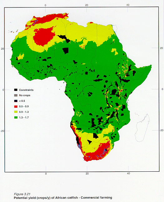
The spatial distribution of the 1stQ yield ranges are very similar for the three fish species (Figures 3.17, 3.18, 3.19, 3.20, 3.21, 3.22) with most of these sites distributed across Africa, north and south of the equator. Common carp and African catfish have similar results for both small-scale and commercial systems; however, the primary difference is that areas with 1st Q suitability are higher for the former under small-scale conditions (Table 3.8). For commercial systems, African catfish apparently have higher potential compared to Common carp. The spatial distributions for the two types of farming systems for Nile tilapia (Figure 3.17 and 3.20; Table 3.8) are similar. However, the small-scale system does show larger spatial areas in the 4thQ yield range for this species (Table 3.8). When comparing Common carp and African catfish to Nile tilapia, more surface areas in the 4thQ yield range for the latter species appear in North Africa (Morocco and Algeria), Southern Africa (Namibia) and in East Africa (Ethiopia, Kenya, Uganda and Tanzania).
Small-scale farming
Nile tilapia
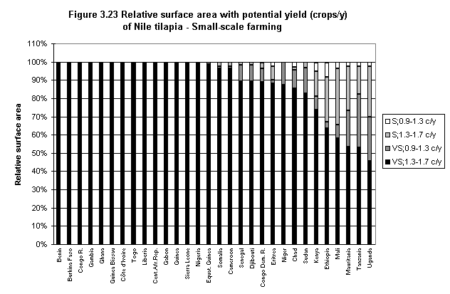
The spatial distribution of small-scale culture opportunities for Nile tilapia (Figure 3.17) is considerably more restrictive
compared to the other two species (Figure 3.18, 3.19). However, 1stQ yields of 1.3 to 1.7
crops/y can be obtained in 50% or more of 29 countries, eight of which possess 1stQ
yields in 100% of their surface area (Figure 3.23).
Zambia, Angola and Mozambique stand out as having 2ndQ yields from 50 to 70% of
their area. Only Lesotho and Tunisia offer no possibilities for yields in the 1stQ
and 2ndQ ranges.
African catfish
32 countries have 50% or more of their land area with 1stQ yields of 1.9 to 2.4 crops/y. Ten countries possess 1stQ yields in 100% of their surface area (Figure 3.18). Moreover, an additional 12 countries have 2ndQ yields from 50 to nearly 100% of their surface area (Figure 3.24). Only Lesotho offers no possibilities for yields in the 1stQ and 2ndQ ranges.
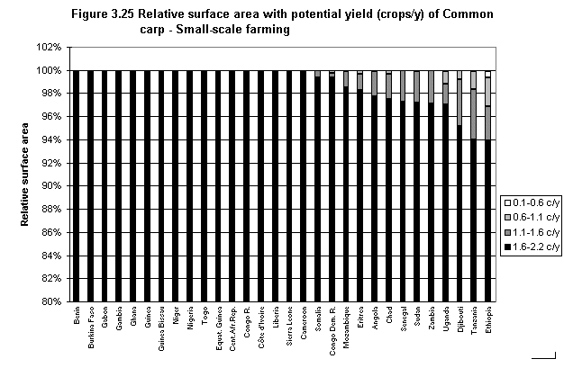
Common carp
Opportunities for small-scale farming of Common carp are extensive (Figure 3.19). 39 countries possess 50 to 100% of their land area with 1stQ yields of 1.6 to 2.2 crops/y, 16 of which have 1stQ yields in 100% of their surface area (Figure 3.25). An additional seven countries contain 2ndQ yields in 50% or more of their area (Figure 3.25). Lesotho is the only country with no possibilities in the 1stQ range.
Commercial farming
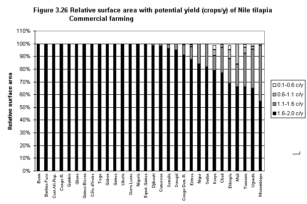
As was the case for small-scale farming, the spatial distribution of Nile tilapia (Figure 3.20) is more restrictive compared to the other two species (Figure 3.21, 3.22). However, the same group of Central African, SE and NW African countries maintain 1stQ crops/y potential. With the exception of eight countries, all African countries are disadvantaged at the 1stQ range (Figure 3.26).
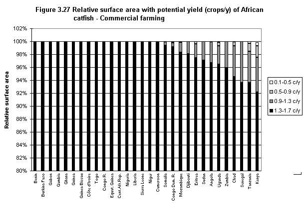
The spatial pattern of African catfish (Figures 3.21 and 3.27) is similar to that of Common carp (Figures 3.22 and 3.28); however, 1stQ crops areas are larger for African catfish.
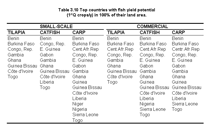
In summary, as would be expected for a species with a relatively wide temperature range for growth, the spatial distribution of Common carp culture is greater compared to the other species (Table 3.9). Common carp and Nile tilapia contrast greatly in the spatial distribution of fish yield potential for both types of culture systems. Nile tilapia is apt for small-scale and commercial farming in as many countries as Common carp and African catfish, but Nile tilapia potential extends over a much smaller area (Table 3.9). The countries which possess 1stQ yields in 100% of their surface area are listed by species in Table 3.10.
All countries have at least some capability to support a reasonable range of yields except for Lesotho which offers no possibilities in the 1stQ and 2ndQ yield ranges.
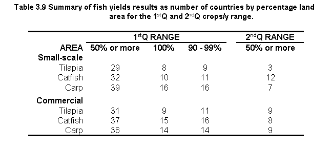
Despite the constraints imposed by meeting the requirements of the farming system models along with those of favourable for fish yields, over 15% of Africa has land areas scored as VS-1stQ for the three fish species and for both types of culture systems (Table 3.11). The largest surface area scored in the VS-1stQ combinations was found for Common carp in the small-scale model. Nile tilapia stands out as being markedly more restrictive than the other two species in the VS-1stQ; however, the opposite occurs in the VS-2ndQ and VS-3rdQ combinations (Table 3.11).
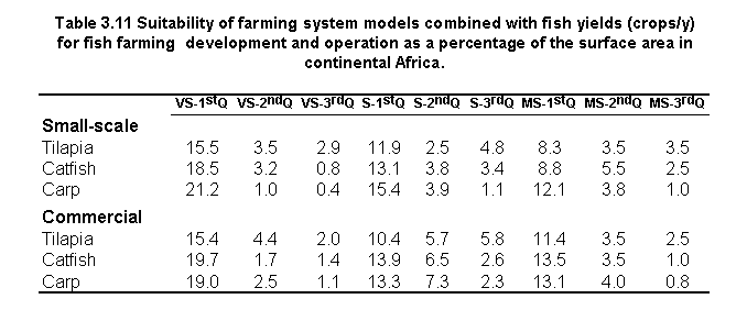
With regard to the S-1stQ and S-2ndQ combinations, Nile tilapia potential again extends over a smaller area in comparison to the other two species (Table 3.11).
Much of the relatively high yield potential is lost and assigned to other combinations as in the case of land areas scored as MS-3rdQ, where Nile tilapia has a higher potential compared with the other two species.
The influence of the two types of farming system models on fish yield output is clearly shown in the spatial pattern of the combined results
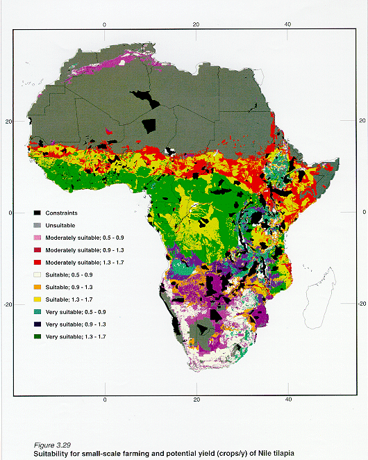
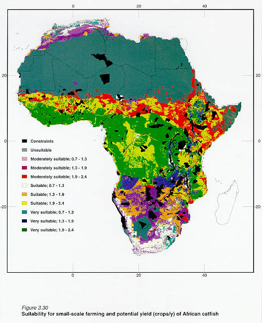
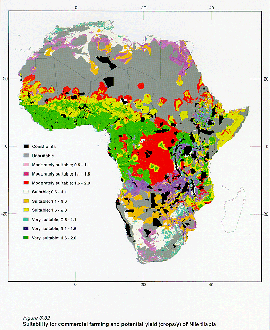
(Figures 3.29, 3.30, 3.31, 3.32, 3.33 and 3.34). The major difference between the two culture systems is that the commercial results show patchy distributions attributed to the urban market size and proximity submodel, a feature that is not present in the small-scale model results.Very suitable sites with 1stQ yield ranges for small-scale farming of the three fish species are located across Africa between 14o - 20o S and 17o _ 40o E. Very suitable locations with 1stQ yield ranges for commercial farming are also located within this geographical range. However, the importance of the urban market size and proximity submodel does identify other areas not identified in the small-scale model as having higher or lower potential such as the Democratic Republic of the Congo and South Africa respectively.
The maps previously presented (Figures 3.29, 3.30, 3.31, 3.32, 3.33 and 3.34) indicate all combinations of model outcomes from VS to US and crops/y outcomes for the 1st, 2nd, 3rdQ and 4thQ ranges. However, in order to draw attention to those areas of Africa where inland fish farming is most favourable, as well as for simplicity and clarity, only the highest ranking combinations are discussed below at a country-level. These are restricted to areas that scored VS or S for the farming system models and areas that are apt for fish crops in the 1stQ and 2ndQ ranges of crops/y.
Small-scale farming
Nile tilapia
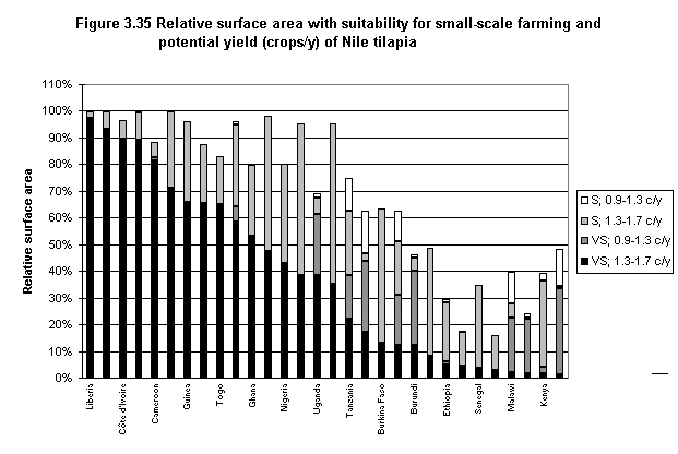
Potential areas for small-scale farming of Nile tilapia have a smaller spatial distribution when compared to the other two species (Figures 3.29, 3.30, 3.31, 3.32, 3.33 and 3.34). Only 11 countries were scored as VS-1stQ in 50% or more of their surface area; however, the ranks of these countries are quite similar to the other species. Moreover, there are 12 countries that have at least 25% of their area that provide S-1stQ possibilities and another six with at least 10% of their area being S-2ndQ (Figure 3.35).
African catfish
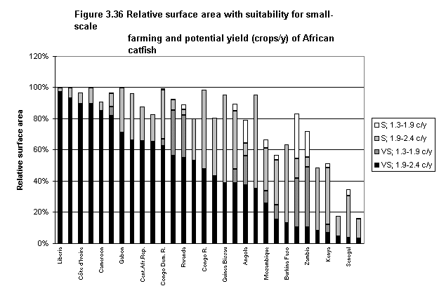
14 countries have 50% or more of their land area scored as VS-1stQ and an additional seven countries possess this score in more than 25% of their area (Figure 3.30). There are 15 countries that exceed S-1stQ possibilities over 25% of their national areas and eight more that scored S-2ndQ in at least 10% of their area (Figure 3.36).
Common carp
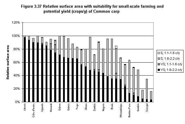
The results for this species are quite similar to those of African catfish in terms of spatial distribution and the rank order of the countries by area (Figures 3.31 and 3.37); however, a few more countries which offer VS-1stQ and S-1stQ possibilities are favoured for Common carp.
Commercial farming
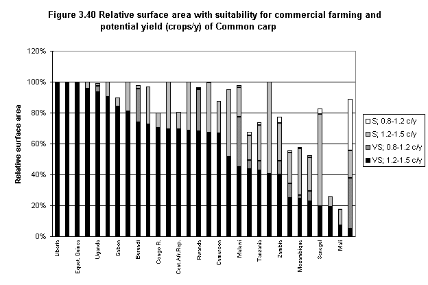
The commercial farming results are similar to those for small-scale farming, except that the spatial distribution of the potential sites for commercial farming is greater for the VS-1stQ, VS-2ndQ and S-2ndQ ranges. Sixteen countries have more than 50% of their area that is VS-1stQ for Nile tilapia (Figure 3.38), whereas there are 19 and 18 countries for African catfish and Common carp respectively in the same category (Figures 3.39 and 3.40). In all there are 11 countries that meet or exceed S-1stQ requirements for 25% or more of their national areas for African catfish, nine for Common carp and eight for Nile tilapia.
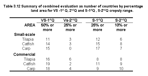
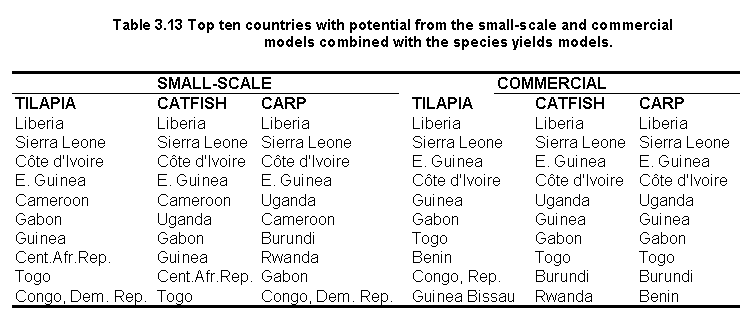
Table 3.12 provides a summary of the combined outputs as number of countries per percentage land area for the different suitability levels. Table 3.13 lists the top ten countries which were found most favourable for inland fish farming in these land quality-fish yield combinations. From the latter list, it is evident that the ranks of the countries are quite similar when comparing fish farming potential among the three species and between the two farming systems. Liberia, Sierra Leone, C�te d'Ivoire, and Equatorial Guinea, were found to be most favourable for the three fish species and for both culture systems.
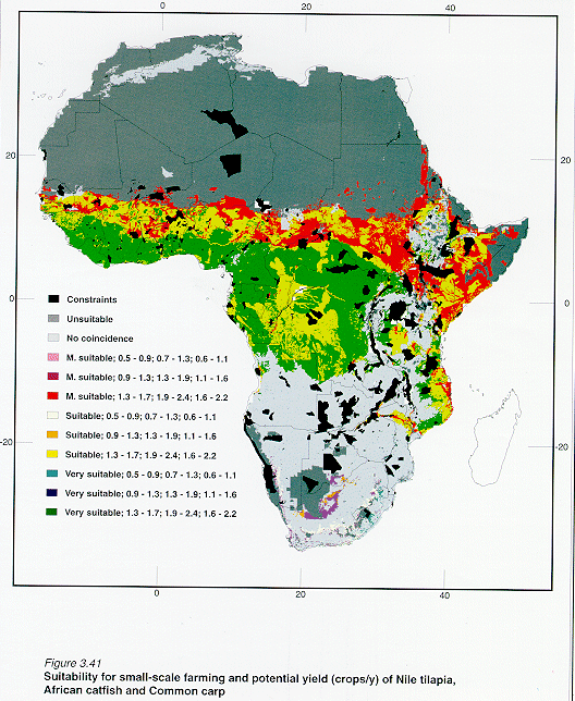
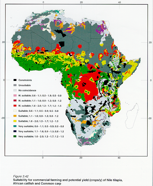
The fish yield outputs (crops/y) presented above for all three fish species were aggregated into four equal length quarters according to their respective crops/y yield ranges. This evaluation was made separately because one may want estimates of fish farming potential according to the species used. However, it is difficult to evaluate the coincidence among fish yields for the three species due to the differences in crops/y yield ranges. To evaluate such coincidence, the results of the combined evaluation (Figures 3.29, 3.30, 3.31, 3.32, 3.33 and 3.34) were combined to identify sites where fish farming is most favourable for the three species by culture system. Thus, Figures 3.29, 3.30 and 3.31) were combined to create a small-scale farming scenario (Figure 3.41) and Figures 3.32, 3.33 and 3.34 were combined to obtain the commercial scenario (Figure 3.42).
Overall, the bulk of the areas scored as VS-1stQ for the three fish species and for both types of culture systems were located in Central and NW Africa between 12o -10o S and 17o - 35o E (Figures 3.41 and 3.42). Other areas outside this geographical range containing this suitability score, but with smaller spatial areas, were located in Ethiopia, Kenya, Tanzania and Mozambique.
The main difference between the two types of farming systems was found in Central Africa (e.g. the Democratic Republic of the Congo), where there is a considerable decrease in areas scored as VS-1stQ and S-1stQ for the commercial model, but much of this potential is gained in the north, at about 12-14oN, where small-scale farming is less suitable.
The results (Table 3.14) show that 37 % of the African surface contains areas with relatively high potential for small-scale farming of Nile tilapia, African catfish and Common carp, and 43% of the African surface has potential for commercial farming for these three species.
Areas with the highest correspondence for each farming system and with the highest suitability score (VS-1stQ) were identified in about 15% of continental Africa (Table 3.14). Similarly, over 10% of the African surface was scored as S-1stQ .

Small-scale and commercial farming
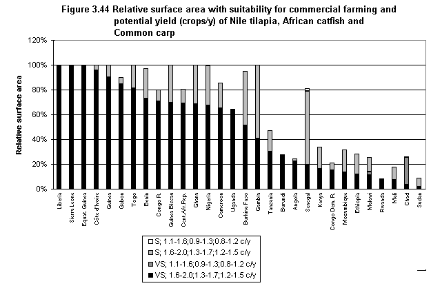
Potential areas for small-scale fish farming have a smaller spatial distribution (Figure 3.41) when compared to commercial farming (Figure 3.42). Only 11 countries possess 50% or more of their national area scored as VS-1stQ for small-scale farming compared to 16 for commercial farming (Figure 3.43 and 3.44). However, the opposite occurs for those areas scored as S-1stQ since small-scale farming has 4 more countries in this suitability category (Table 3.15).
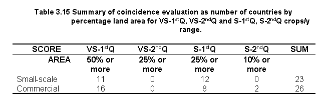
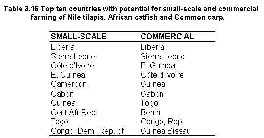
Table 3.16 provides a list of the top ten countries (in rank order) which were found to be most favourable for inland fish farming of the three fish species for each type of farming system. The list shows that Liberia and Sierra Leone were ranked as the top two countries for both types of culture systems. Two countries (C�te d'Ivoire and Equatorial Guinea) were also high on the top ten list for both small-scale and commercial farming systems.
For clarity, verification results are presented separately by general and water temperature categories. In addition, general verification results are presented from another perspective: verification by existing farm locations and by the number of farms at a county-level.
Results are presented for the three fish species and for both types of farming systems. However, because most of the fish farms for which information was available for verification are reported to raise Nile tilapia, the farming potential of this species is the focus of the discussion below.
ZIMBABWE
Verification work required locations of the fish farms and attribute data. The
locations were obtained by visiting farm sites with a GPS receiver. The objective of the
work was to locate and characterise a number of farm sites and operations among areas that
differed from one another in terms of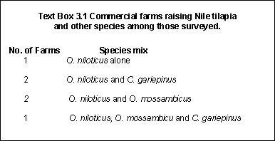 water requirement, terrain, availability of
inputs, farm-gate sales, proximity to roads and markets, water temperature and fish
weights at harvest. Characterisation of the farms was based upon the description of the
factors (e.g., water requirement) and thresholds established in this study.
water requirement, terrain, availability of
inputs, farm-gate sales, proximity to roads and markets, water temperature and fish
weights at harvest. Characterisation of the farms was based upon the description of the
factors (e.g., water requirement) and thresholds established in this study.
A total of 9 commercial fish farms were visited across Zimbabwe. Farm selection was based on an inventory of commercial fish farms (57 in total) carried out by Balarin, Chisawa and Evans (1997). Contrary to information from the latter inventory, field verification work by Zimudzi (1997) found that some farmers had never practised fish farming on any scale except to stock a few ponds. Due to time and resource limitations no small-scale fish farms were visited. Moreover, although 9 farms were visited, only 6 were operational and therefore only the results for these are presented below.
Most farms visited either exclusively or predominantly raised Nile tilapia (Oreochromis
niloticus) (Text box 3.1). Although some farms r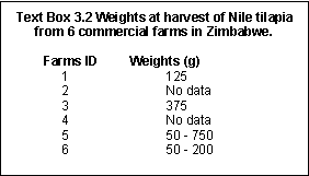 aised
O. mossambicus, it is not a popular species for culture due to excessive
recruitment and slower growth rate. In two instances, Clarias gariepinus was
stocked to control the breeding of both O.mossambicus and frogs.
aised
O. mossambicus, it is not a popular species for culture due to excessive
recruitment and slower growth rate. In two instances, Clarias gariepinus was
stocked to control the breeding of both O.mossambicus and frogs.
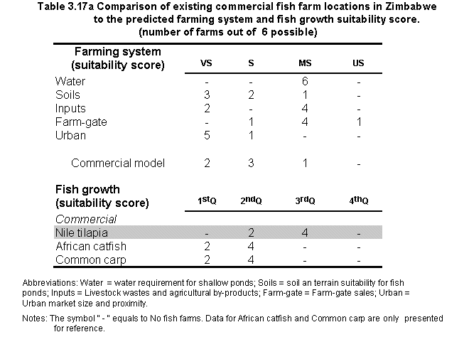
The weights at harvest of Nile tilapia varied considerably among the six commercial fish farms from a minimum weight of 50 g to a maximum of 750 g (Text Box 3.2). The evaluation for commercial farming of Nile tilapia showed that most farms were found in areas scored as MS among the land quality factors (Table 3.17a).
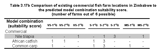
All except one of the farms scored VS for urban market size and proximity, but water requirement was found to be the most limiting factor for all the farms (Table 3.17a). Despite this, the outcome of the commercial model showed that 3 of the 6 farms were in areas scored as S. Moreover, 2 farms were in grid cells predicted to yield crops of Nile tilapia in the 2ndQ range and 4 in the 3rdQ range (Table 3.17b). The combined evaluation showed that 4 of the farms are located in areas that scored S, one in the 2ndQ range and three in the 3rd Q. In addition, one farm was located in an area scored as VS, with yield ranges in the 3rd Q. None of the farms were located in areas where potential for farming of the three species coincided.
Database verification
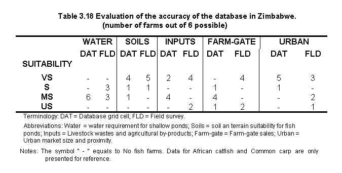
To evaluate the accuracy of the database developed in this study, information obtained by Zimudzi (1997) was scored according to the thresholds first established in the methods section of this study. This approach enabled a comparison among the scores obtained from the six farms visited with those defined in the database.
Lack of field data did not allow the development of a quantitative estimate of the accuracy of the database. However, from indicative analyses (Table 3.18) it was found that soils and slopes had the highest accuracy (i.e., 4 farms that scored VS on the field were located in 4 grid cell sites also scored as VS). Water requirement predictions were also found to be accurate, water is in most cases insufficient due to low-rainfall conditions. Lowest accuracy was found for farm-gate sales because higher suitability was found on the field, and this was also found to be the case for inputs. Conversely, scores for urban size and proximity to markets were found to be lower in the field. For example, one of the farmers has to travel 175 km one way to an urban market.
KENYA
All of the 31 small-scale farms for which information was available raised Nile tilapia. Moreover, according to Marquet, Achieng and Obuya (1996) African catfish is also very acceptable in this area, but only a few farmers can raise this species because very few fry survive and adequate information on managing fry ponds is not available.
The outcome of the comparison shows that the majority of farms were located in areas scored as VS among the factors selected for evaluating the quality of the land (Table 3.19a).
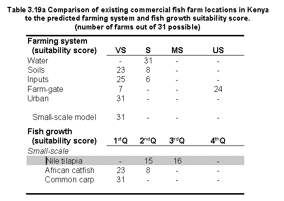
All farms were located within easy reach of urban markets. Twenty four farms were scored US for farm-gate sales because they were located in high population density areas where the land could be too expensive for small-scale farming, however, a high population density also implied a potential market source (see section 2.3.5 above). Moreover, of the 24 farms, 17 were located in areas having 301 - 450 i/km2 meaning that the population density thresholds were slightly higher than the VS threshold of 150 - 300 i/km2, (see Text Box 2.9 in section 2.3.5 above). Likewise, in spatial terms, the farms were very close or adjacent to the VS areas. In conclusion, the 24 farms classified as US for farm-gate sales could be re-classified as MS by a slight increase of the limit at which land would become to expensive (i.e. 300 i/km2).
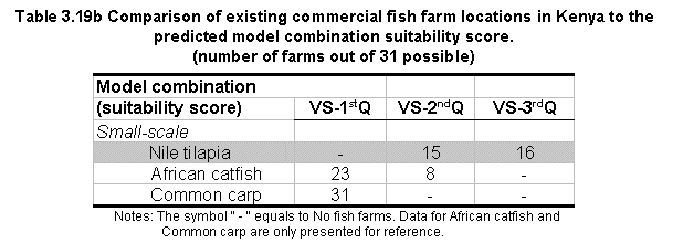
All of the farms were in grid cell sites scored as VS by the small-scale model (Table 3.19a) and 15 farms were in cells predicted to yield crops in the 2ndQ range; and an additional 16 predicted yields in the 3rdQ range. The combined evaluation (Table 3.19b) showed that 15 farms were located in areas scored as VS-2ndQ and 16 additional farms possess a score of VS-3rdQ. None of the farms were located in areas where potential for farming of the three species coincided.
UGANDA
Data on fish farming in Uganda (Candia, 1997) were only available for Arua district by
the number of fish farms at a county-level (Text Box 3.3). All of the 202 farms are
reported to raise Tilapia alone and most of the farms were using small-scale methods for
culture.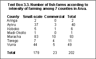
Digital data for county boundaries was not available for Arua district, so these data were digitized from a paper map at a 1:1,500,000 scale (Department of Lands and Surveys, 1986). Once the data were digitized, the database was transformed to the base grid (i.e., grid cell size of 3 minutes and Lat/Long. projection).
The objective was to examine the areas covered by each fish farming suitability class for Nile tilapia for each county in Arua, and then to compare this with the number of fish farms by district (Text Box 3.3).
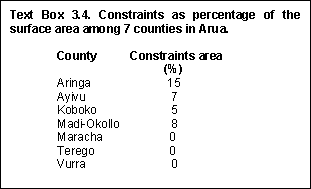
Protected areas were identified in 4 of the 7 counties in Arua district, with the largest surface area in Aringa comprising about 15% of the county (Text Box 3.4).
The verification results show that among the land quality factors, the least limiting factor is the urban market; all seven counties scored VS in 100% of their area (Table 3.20). In contrast, the most limiting factor is the inputs, as five counties have 35 to 100% of their surface area scored as US.
The commercial model shows that very suitable sites occur in all counties in 100% of their area. Good, but lower potential was found for small-scale farming (i.e., four counties with 100% at the VS level).
The spatial distribution of fish farming opportunities for Nile tilapia are extensive in that almost all the counties possess 1stQ yields in 100% of their surface area for both small-scale and commercial farming (Table 3.20). Similarly, the outcome of the combined evaluation is also very positive. All counties except Vurra for the small-scale model combination had most, if not all of their land area scored as VS-1stQ for both culture systems. Interestingly, the potential for the culture of the three species is also high as indicated by the coincidence evaluation.
To verify the predictions, it was assumed that the greater the number of fish farms the higher the potential for fish farming. However, it was difficult to corroborate this assumption in order to pin-point the county with the highest number of fish farms (i.e., Maracha) because all the predictions showed similar potential for all counties. This difficulty is attributable to two sources:
a) the use of choropleth data (i.e., data that cover a large area), and
b) the lack of data on all farm characteristics such as availability of inputs.
Despite this difficulty, the results do confirm the fact that Arua is one of the districts of Uganda with considerable aquaculture potential as concluded by Candia (1997).

The water temperature predicted in this study for a grid cell characterises its entire area primarily based on air temperature (see Appendix 8.1 for details of air temperature). Monthly maps and statistical results of the water temperature predictions at a continental-level are presented in Appendix 8.8. However, for verification purposes, the database was queried for water temperature predictions for 3 countries where a general verification was conducted as described above; additionally, water temperature data for Malawi was also included (Table 3.21).
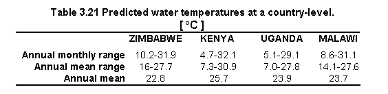
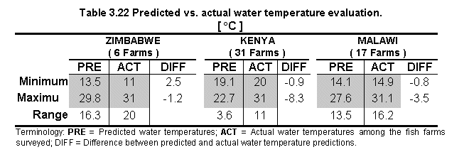
In order to compare predicted and actual water temperature values, the database was queried for those grid cells where existing fish farms were located. Farm data on water temperature were not available for Uganda, but data from Malawi were available (Table 3.22).
The comparison shows that predictions for minimum water temperatures were found to be in close agreement with the actual values. Predicted maximum temperatures were lower than actual values (Table 3.22), particularly for Kenya. This may be due to the fact that the comparison for this country was done between predicted water temperature (based on mean air temperatures calculated over a large number of years) and actual water temperature for the month of July 1996 alone. Significant variations can occur from year to year in the annual pattern of both air and water temperatures (see also Appendix 8.8). All in all, the comparison shows that there is a tendency towards both lower values and a narrower range for predicted temperatures. This tendency was also found in the Latin America study by Kapetsky and Nath (1997) and in part may account for poor predictions of fish yields in the grid cells where active fish farms exist. Despite this, and as opposed to the Latin America study, the present one did not find any fish farms located in grid cells predicted as US for fish farming which, in turn, implies that there was an increase in the accuracy of the water temperature predictions.
![]()
![]()
![]()