FIRMS Marine Resources inventories placemarks
FIRMS Fishery resources placemarks
Simple
- Date (Publication)
- 2024-07-03
- Edition
-
2024.1.0
- Citation identifier
- firms_resource_placemarks
- Cited responsible party
-
Organisation name Individual name Electronic mail address Role Food and Agriculture Organization of the United Nations
Owner
- Presentation form
- Digital map
- Purpose
-
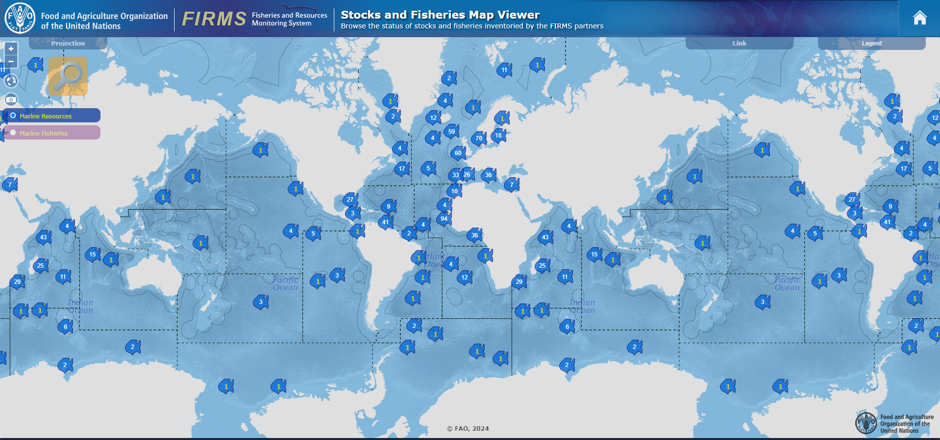
The purpose of this dataset is to show the geographic coverage of FIRMS resource inventories.The dataset can be visualized at https://www.fao.org/fishery/geoserver/factsheets/firms.html?layer=resource
- Status
- published
- Point of contact
-
Organisation name Individual name Electronic mail address Role Food and Agriculture Organization of the United Nations
Owner Fisheries and Resources Monitoring System (FIRMS) Secretariat
Publisher FAO - Statistics and Information Branch (NFIS)
Emmanuel Blondel
Point of contact FAO - Statistics and Information Branch (NFIS)
Aureliano Gentile
Point of contact
- Maintenance and update frequency
- As needed
- Resource format
-
Name Version application/zip
- Use limitation
-
The terms and conditions are available at https://www.fao.org/contact-us/terms/en
- Use limitation
-
Disclaimer: The designations employed and the presentation of material in the map(s) are for illustration only and do not imply the expression of any opinion whatsoever on the part of FAO concerning the legal or constitutional status of any country, territory or sea area or concerning the delimitation of frontiers or boundaries
- Use limitation
-
Usage subject to mandatory citation: © FAO, 2024. FIRMS Marine resource inventory geographic placemarks. In: FAO - Fisheries and Aquaculture Division (NFI) [online]. Rome. Updated 2024-07-03 [Cited <DATE>] https://www.fao.org/fishery/geonetwork?uuid=firms_resource_placemarks
- Spatial representation type
- Vector
- Language
- English
- Character set
- UTF8
))
- Reference system identifier
- EPSG / 4326
- Topology level
- Geometry only
- Geometric object type
- Point
- Geometric object count
- 931
- Distribution format
-
Name Version application/zip
- Distributor contact
-
Organisation name Individual name Electronic mail address Role FAO - Statistics and Information Branch (NFIS)
Emmanuel Blondel
metadata
- OnLine resource
- Hierarchy level
- Dataset
- Statement
-
The data management workflow was automated using the geoflow R package (available at https://github.com/r-geoflow/geoflow) using the following steps
- Description
-
FIRMS inventories were accessed from the API (available at https://www.fao.org/fishery/monikerj/firms/firmsmarineresources). Reference geospatial layers were accessed from the FAO Fisheries & Aquaculture GeoServer (available at https://www.fao.org/fishery/geoserver) using the OGC Web Feature Service protocol
- Rationale
-
Access
- Description
-
Geographic placemarks were processed and compiled using the RFirmsGeo R package (available at https://github.com/openfigis/RFirmsGeo)
- Rationale
-
Processing
- Rationale
-
Upload and publication[Geographic placemarks are published as geospatial layer in the FAO Fisheries & Aquaculture GeoServer (available at https://www.fao.org/fishery/geoserver). Geographic information metadata is made available in the FAO Fisheries & Aquaculture GeoNetwork (available at https://www.fao.org/fishery/geonetwork) and through the GeoInfo portal (available at https://www.fao.org/fishery/geoserver/geoinfo/)]_
- Compliance code
- Yes
- Language
-
eng
- Included with dataset
- No
- Feature catalogue citation
Metadata
- File identifier
- firms_resource_placemarks XML
- Metadata language
- English
- Character set
- UTF8
- Hierarchy level
- Dataset
- Date stamp
- 2024-12-18T01:44:48
- Metadata standard name
-
ISO 19115:2003 Geographic information - Metadata
- Metadata standard version
-
ISO 19115:2003
- Metadata author
-
Organisation name Individual name Electronic mail address Role FAO - Statistics and Information Branch (NFIS)
Emmanuel Blondel
Point of contact
- Dataset URI
-
firms_resource_placemarks
Overviews


Spatial extent
Provided by
