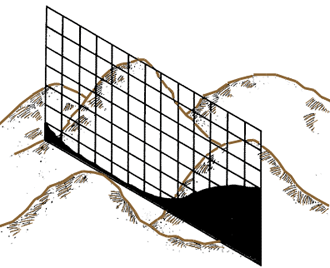
Horizontal area
Cross-section area
1. One of the main purposes of your topographical survey may be to determine the area of a tract of land where you want to build a fish-farm. From existing topographical maps, you may need to calculate the area of a watershed or of a future reservoir (see Water, Volume 4 in this series).
Note: in land surveying, you should regard land areas as horizontal surfaces, not as the actual area of the ground surface. You always measure horizontal distances.
2. You will often need to know the areas of cross-section profiles to calculate the amount of earthwork you need to do.
|
Horizontal area
|
Cross-section area
|
3. You may determine areas either directly from field measurements, or indirectly, from a plan or map. In the first case, you will find all the measurements of distances and angles you need by surveying, and you will calculate the areas from them. In the second case, you will draw a plan or map first (see Chapter 9). Then you will get the dimensions you need from the scale, and determine the area on that basis.
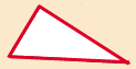
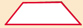
4. There are several simple methods available for measuring areas. Some of these are graphic methods, where you compare the plan or map of the area you need to measure to a drawn pattern of known unit sizes. Others are geometric methods, where you use simple mathematical formulas to calculate areas of regular geometrical figures, such as triangles, trapeziums*, or areas bounded by an irregular curve.
Note: a trapezium is a four-sided polygon with two parallel sides.
5. The simple methods will be described in detail in the next sections. They are also summarized in Table 13.
|
Triangle
|
Trapezium 1

|
|
|
Trapezium 2
|
Irregular area

|
|
TABLE 13
|
10.2 How to use the strips method for measuring areas |
||
|
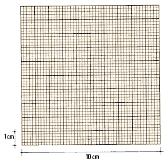
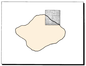
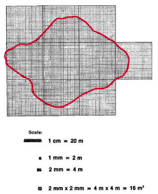
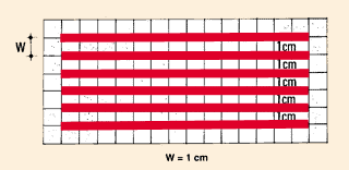
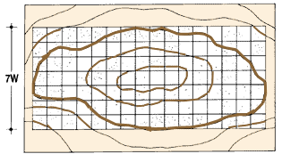
1. Get a piece of transparent paper, such as tracing paper or light-weight square-ruled millimetric paper. Its size will depend on the size of the mapped area you need to measure. 2. On this paper, draw a series of strips, by drawing a series of parallel lines at a regular, fixed interval. Choose this strip width W to represent a certain number of metres. You can follow the scale of the plan or map to do this. |
 |
|
|
Example Scale 1: 2 000; strip width W = 1 cm = 20 m. Note: the smaller the strip width, the more accurate your estimate of the land area will be. 3. Place the sheet of transparent paper over the plan or map of the area you need to measure, and attach it securely with drawing pins or transparent tape. |
Scale: 1: 2.000
 |
|
|
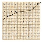
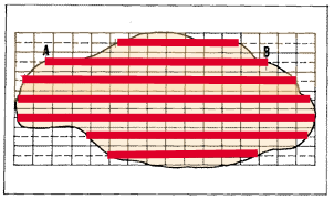
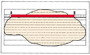
4. For each strip, measure the distance AB in centimetres along a central line between the boundaries of the area shown on the map. 5. Calculate the sum of these distances in centimetres. Then, according to the scale you are using, multiply to find the equivalent distance in the field, in metres. |
 |
|
|
Example Scale is 1 :2000 and 1 cm = 20 m. |
 |
|
|
6. Multiply this sum of real distances (in metres) by the equivalent width of the strip W (in metres) to obtain a rough estimate of the total area in square metres. Example Sum of equivalent distances is 320 m. Note: 10000 m2 = 1 hectare (ha) 7. Repeat this procedure at least once to check on your calculations. |
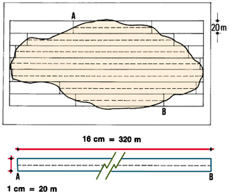 Total area = 320 m x 20 m = 6400 m2 |
|
1. When you need to measure areas directly in the field, divide the tract of land into regular geometrical figures, such as triangles, rectangles or trapeziums. Then take all the necessary measurements, and calculate the areas according to mathematical formulas (see Annex 1). If a plan or map of the area is available, you can draw these geometrical figures on it, and find their dimensions by using the reduction scale.
2. In the first manual in this series, Water for Freshwater Fish Culture, FAO Training Series (4), Section 2.0, you learned how to calculate the area of a pond using this method. In the following steps, you will learn how to apply it under more difficult circumstances.
 |
 |
|
 |
 |
Measuring areas by triangles |
||||
|
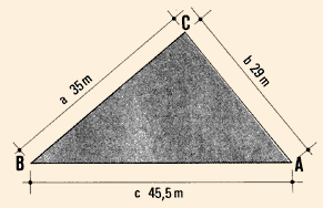
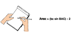
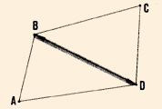
3. You can easily calculate the area of any triangle when you know the dimensions of:
where s = (a + b + c) ÷ 2; Example If a = 35 m; b = 29 m; and c = 45.5 m. Then s = (35 m + 29 m + 45.5 m) ÷ 2 = 54.75 m Area2 = 54.75 m (54.75m - 35 m) (54.75 m - 29 m)(54.75
m - 45.5 m) Area = Ö(257 555 m4) = 507 m2
|
|
|||
|
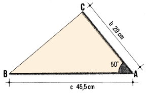
Example If b = 29 m; c = 45.5 m; and angle BAC
= 50°. |
|
|||
|
Sine values of angles
|
|
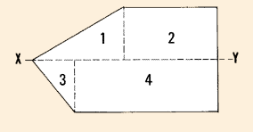
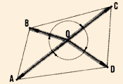
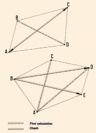
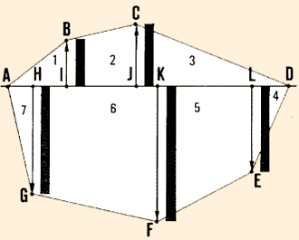
4. Subdivide the tract of land into triangles. For a four-sided area, you can do this in two ways.
|
Two triangles
 |
|
|
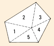
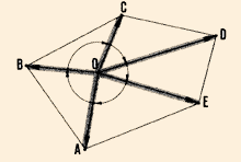
5. On a land tract with more than four sides, you can subdivide its area into triangles:
|
Radiation from a central station
|
|
|
Radiation from a central station
 |
Radiation from a lateral station
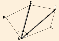 |
|
6. Check on your calculations. If you have found the area by using two opposite angles, use the first procedure. If you have proceeded by radiating, use the second.
|
 |
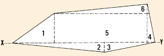
Using a base line to subdivide land areas |
||||||||||||||||||||||||||||||||||||||||||||||||||||||||||
|
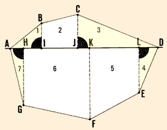
7. When the shape of the land is polygonal*, you should usually subdivide the total area you need to measure into a series of regular geometrical figures (1-7 in the example) from a common base line AD. You will lay out offsets from the other summits of the polygon* which are perpendicular to this base line to form right triangles 1,3,4 and 7, and trapeziums 2, 5 and 6. 8. When you are choosing a base line, remember that it should:
|
Area = (base x height) ÷ 2
 |
|||||||||||||||||||||||||||||||||||||||||||||||||||||||||
|
9. Calculate the area of each right-angled triangle*, using the formula:
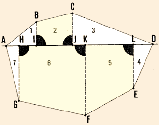
10. Calculate the area of each trapezium, using the formula:
where:
|
Area = Height x (base 1 + base 2) ÷ 2
 |
|||||||||||||||||||||||||||||||||||||||||||||||||||||||||
|
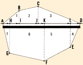
11. Add together all these partial areas to find the total land area. You should use a table to enter alI the basic dimensions for both right triangles (one base) and trapeziums (two bases), as shown in the example. Example
Base line (in m) |
 |
|||||||||||||||||||||||||||||||||||||||||||||||||||||||||
Base line (in m)
|
 |
|||||||||||||||||||||||||||||||||||||||||||||||||||||||||
1TR = right-angled triangle; TP trapezium |
||||||||||||||||||||||||||||||||||||||||||||||||||||||||||
Subdividing land areas without base lines |
||||||||||||||||||||||||||||||||||||||||||||||||||||||||||
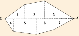
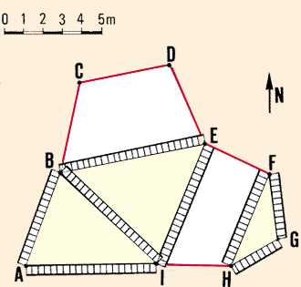
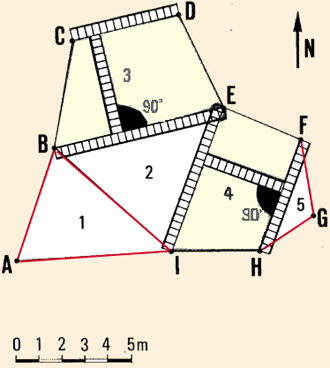
| 12. When the shape of the land is more complicated than the ones you have just learned to measure, you will have to use more than one base line, and subdivide the area into triangles, and trapeziums of various shapes. Usually there will be no existing right angle for you to work with and you will have to calculate the area of the trapeziums by taking additional measurements, which will determine their heights along perpendicular lines. |
 |
|||||||||||||||||||||||||||||||||||||||||||||||||||||||||
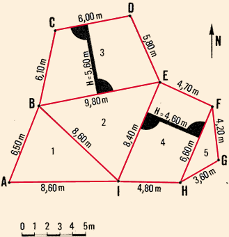
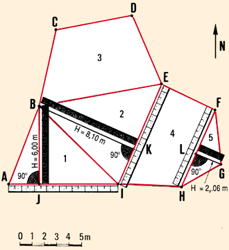
Example
Land tract ABCDEFGHIA along a river is subdivided into five lots 1-5 representing three triangles (1,2,5) and two trapeziums (3 with BE parallel to CD, and 4 with EI parallel to FH). The land boundary forms a closed polygon, which has been surveyed as shown.
|
13. Calculate the areas of triangles 1, 2 and 5, using the lengths of their three sides and the following formulas:
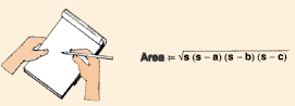
Example Take measurements of the sides of the triangles, as necessary. Apply the formula area = Ös(s- a)(s- b)(s-c) in the following table:
|
 |
||||||||||||||||||||||||||||||||||||||||||||||||||||||
|
14. Calculate the areas of trapeziums 3 and 4, determining their heights and base lengths, and using the following formula:
Example Measure the heights and bases of the trapeziums, as necessary. Apply the formula in the following table:
15. Add the total area of the triangles (step 12) to the total area of the trapeziums (step 14) to obtain total land tract area. Example Total area of triangles = 667337
m2 |
 |
||||||||||||||||||||||||||||||||||||||||||||||||||||||
|
16. Another way of making the calculations easier is to measure from a plan the height of each triangle along the perpendicular laid out from one angle summit to the opposite side (called the base). Then, to calculate each triangle area as:
Enter all the data in a single table, as explained in step 11, above. Example From a plan, measure heights BJ, BK and LG for triangles 1,2, and 5, respectively. Enter all the data in the following table:
The total area of the land tract is 145.36 ha, which is slightly different from the previous estimate (see step 15). This was caused by scaling errors when measuring from the plan, which in this case are small enough (0. 11 ha or 0.07 percent) to be permissible. |
 |
||||||||||||||||||||||||||||||||||||||||||||||||||||||
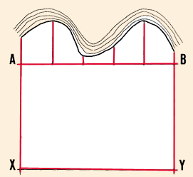
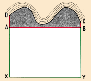
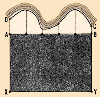
3. Set out straight line AB joining the sides of the tract of land and running as closely as possible to the curved boundary. To determine the irregular area ABCDA, proceed as follows.
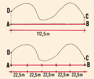
4. Measure distance AB and subdivide it into a number of regular intervals, each, for example, 22.5 m long. Mark each of the intervals on AB with ranging poles.
Note: the shorter these intervals are, the more accurate your area estimate will be.
 |
 |
|
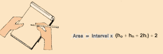
5. At each of these marked points, set out a perpendicular line joining AB to the curved boundary. Measure each of these offsets. 6. Calculate area ABCDA using the following formula:
|
 |
||
|
where:
|
 |
||
|
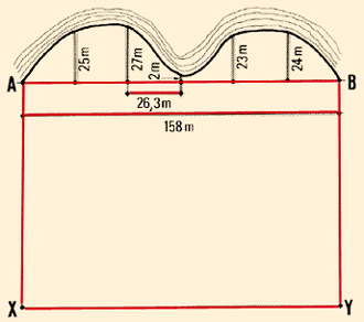
Example Interval = 112.5 m ÷ 5 = 22.5 m Note: remember that you must still calculate the area of AXYBA and add it to the area of ABCDA to get the total area DAXYBCD. |
 |
||
|
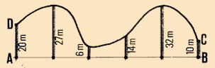
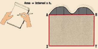
7. If you can lay out line AB so that it touches the two ends of the curved boundary, your calculations will be much simpler. In this case, ho and hn are both equal to zero, and the formula becomes:
where hi is the sum of the lengths of all the intermediate offsets. |
 |
||
|
Example Interval = 158 m ÷ 6 = 26.3 m Note: remember that you must still calculate the area of AXYBA and add it to the area of the curved section to get the total area. |
 |
![]()