![]()
![]()
![]()
3.1 Slopes
3.2 Elevation of a point
3.3 Contour lines
3.4 Maps
3.1.1 Definition
3.1.2 Method of expressing slopes
3.1.3 Cross slopes
A slope is the rise or fall of the land surface. It is important for the farmer or irrigator to identify the slopes on the land.
A slope is easy to recognize in a hilly area. Start climbing from the foot of a hill toward the top, this is called a rising slope (see Fig. 46, black arrow). Go downhill, this is a falling slope (see Fig. 46, white arrow).
Fig. 46. A rising and a falling slope

Flat areas are never strictly horizontal; there are gentle slopes in a seemingly flat area, but they are often hardly noticeable to the naked eye. An accurate survey of the land is necessary to identify these so called "flat slopes".
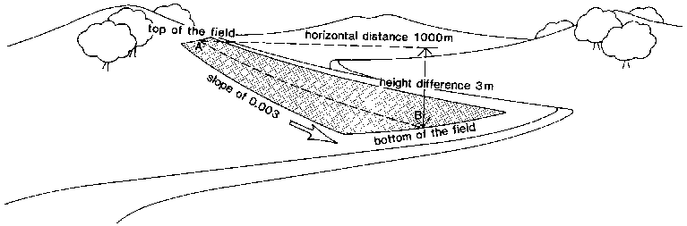
The slope of a field is expressed as a ratio. It is the vertical distance, or difference in height, between two points in a field, divided by the horizontal distance between these two points. The formula is:
|
|
An example is given in Fig. 47.
Fig. 47. The dimensions of a slope

The slope can also be expressed in percent; the formula used is then:
|
|
Using the same measurements shown in Fig. 47:

Finally, the slope can be expressed in per mil; the formula used is then:
|
|
with the figures from the same example:

NOTE:
|
Slope in ‰ = slope in % x 10 |
QUESTION
What is the slope in percent and in per mil of a field with a horizontal length of 200 m and a height difference of 1.5 m between the top and the bottom?
ANSWER

Field slope in ‰ = field slope in % x 10 = 0.75 x 10 = 7.5‰
QUESTION
What is the difference in height between the top and the bottom of a field when the horizontal length of the field is 300 m and the slope is 2‰.
ANSWER

thus: height difference (m) = 0.002 x 300 m = 0.6 m.
The following table shows a range of slopes commonly referred to in irrigated fields.
|
Slope |
% |
‰ |
|
Horizontal |
0 - 0.2 |
0 - 2 |
|
Very flat |
0.2 - 0.5 |
2 - 5 |
|
Flat |
0.5 - 1 |
5 - 10 |
|
Moderate |
1 - 2.5 |
10 - 25 |
|
Steep |
more than 2.5 |
more than 25 |
Place a book on a table and lift one side of it 4 centimetres from the table (Fig. 49a). Now, tilt the book sideways (6 cm) so that only one corner of it touches the table (Fig. 49b).
Fig. 49a. Main slope

Fig. 49b. Main slope and cross slope

The thick arrow indicates the direction of what can be called the main slope; the thin arrow indicates the direction of the cross slope, the latter crosses the direction of the main slope.
An illustration of the main slope and the cross slope of an irrigated field is shown in Fig. 50.
Fig. 50. The main slope and cross slope of an irrigated field

In figure 51, point A is at the top of a concrete bridge. Any other point in the surrounding area is higher or lower than A, and the vertical distance between the two can be determined. For example, B is higher than A, and the vertical distance between A and B is 2 m. Point C, is lower than A and the vertical distance between A and C is 1 m. If point A is chosen as a reference point or datum, the elevation of any other point in the field can be defined as the vertical distance between this point and A.
Fig. 51. Reference point or datum "A"

Thus, the height or elevation of B, in relation to the datum A, is 2 m and the elevation of C, also related to the datum A, is 1 m.
As a reminder that a point is above or below the datum, its elevation is prefixed by the sign + (plus) if it is above the datum, or - (minus) if it is below the datum.
Therefore, in relation to the datum A, the elevation of B is +2 m and the elevation of C is -1 m.
A bench mark is a permanent mark established in a field to use as a reference point. A bench mark can be a concrete base in which an iron bar is fixed, indicating the exact place of the reference point.
A bench mark can also be a permanent object on the farm, such as the top of a concrete structure.
In most countries the topographical departments have established a national network of bench marks with officially registered elevations. All bench mark heights are given in relationship to the one national datum plane which in general is the mean sea level (MSL) (see Fig. 52).
Fig. 52. A bench mark (B.M.) and mean sea level (M.S.L.)

EXAMPLE
In Figure 52, the elevation of point A in relation to the bench mark (BM) is 5 metres. The BM elevation relative to the mean sea level (MSL) is 10 m. Thus, the elevation of point A relative to the MSL is 5 m + 10 m = 15 m and is called the reduced level (RL) of A.
QUESTION
What is the reduced level of point B in Figure 52.
ANSWER
The elevation of B relative to BM = 3 m
The elevation of BM relative to MSL = 10 m
Thus, the reduced level of B = 3 m + 10 m = 13 m
QUESTION
What is the difference in elevation between A and B? What does it represent?
ANSWER
The difference in elevation between A and B is the reduced level of A minus the reduced level of B = 15 m - 13 m = 2 m, which represents the vertical distance between A and B.
A contour line is the imaginary horizontal line that connects all points in a field which have the same elevation. A contour line is imaginary but can be visualized by taking the example of a lake.
The water level of a lake may move up and down, but the water surface always remains horizontal. The level of the water on the shore line of the lake makes a contour line because it reaches points which are all at the same elevation (Fig. 53a).
Fig. 53a. The shore line of the lake forms a contour line
Suppose the water level of the lake rises 50 cm above its original level. The contour line, formed by the shore line, changes and takes a new shape, now joining all the points 50 cm higher than the original lake level (Fig. 53b).
Fig. 53b. When the water level rises, a new contour line is formed
Contour lines are useful means to illustrate the topography of a field on a flat map; the height of each contour line is indicated on the map so that the hills or depressions can be identified.
3.4.1 Description of a map
3.4.2 Interpretation of contour lines on a map
3.4.3 Mistakes in the contour lines
3.4.4 Scale of a map
Fig. 54 represents a three-dimensional view of a field with its hills, valleys and depressions; the contour lines have also been indicated.
Fig. 54. A three-dimensional view
Such a representation gives a very good idea of what the field looks like in reality. Unfortunately, it requires much skill to draw and is almost useless for the designing of roads, irrigation and drainage infrastructures. A much more accurate and convenient representation of the field, on which all data referring to topography can be plotted, is a map (Fig. 55). The map is what you see when looking at the three-dimensional view (Fig. 54) from the top.
The arrangement of the contour lines on a map gives a direct indication of the changes in the field's topography (Fig. 55).
Fig. 55. A two-dimensional view or map
In hilly areas, the contour lines are close together while they are wider apart on flat slopes. The closer the contour lines, the steeper the slope. The wider the contour lines, the flatter the slopes.
On a hill, the contour lines form circles; whereby the values of their elevation increase from the edge to the centre.
In a depression, the contour lines also form circles; the values of their elevation, however, decrease from the edge to the centre.
Contour lines of different heights can never cross each other. Crossing countour lines would mean that the intersection point has two different elevations, which is impossible (see Fig. 56).
Fig. 56. WRONG; crossing contour lines
A contour line is continuous; there can never be an isolated piece of contour line somewhere on the map, as shown in Figure 57.
Fig. 57. WRONG; an isolated piece of contour line
To be complete and really useful, a map must have a defined scale. The scale is the ratio of the distance between two points on a map and their real distance on the field. A scale of 1 in 5000 (1:5000) means that 1 cm measured on the map corresponds to 5000 cm (or converted into metres, 50 m) on the field.
QUESTION
What is the real distance between points A and B on the field when these two points are 3.5 cm apart on a map whose scale is 1 to 2 500? (see Fig. 58)
Fig. 58. Measuring the distance between A and B
ANSWER
The scale is 1:2 500, which means that 1 cm on the map represents 2 500 cm in reality. Thus, 3.5 cm between A and B on the map corresponds to 3.5 x 2 500 cm = 8 750 cm or 87.5 m on the field.
![]()
![]()
![]()
 ..... (14a)
 ..... (14b)
 ..... (14c)