


An increasing number of international and regional processes are requesting forest related information from countries on structure and multiple functions of forests and the civil society is increasingly concerned about forest resources and wants to be informed on sustainability of forests and its goods and services.
The thematic assessment component of FRA 2005 basically attempts to serve the above diverse demands of international process and agencies as well as civil society at large. In doing so, it plans to assess the state of forest resources, their goods and services in a country against six of the seven Thematic Areas or Criteria (CICI, 2003) common to all the nine regional processes of Criteria and Indicators. Such thematic assessment expects to provide comprehensive inputs to develop effective national policies and strategies for sustaining forest resources and to maximize their social, economic and ecological benefits. The example also presents an optional alternative process (integrated assessment) that leads to a review of the sustainability of forest resources in a country.
This section first presents the information collection process for thematic assessment of forest resources, which is followed by an analytical phase indicating changes over time with the help of temporal trends. Finally the section presents national official opinion on the state of forest based on the past and forecasted trends
The National Forest Act (Act No. 84 of 1998) mandates the government, among its other obligation in terms of the forests, to monitor and report on the state of the resources. In response to this requirement, a formalised biogeography-floristic classification of the South African indigenous forest was developed by the Centre for Scientific and Industrial Research (CSIR). This was based on analysis of information from over 4500 plots from 427 forests around the country. The same institution was also commissioned to develop a classification system for woodlands for the purposes of policy, management and monitoring. The new woodland classification, classified woodlands to include those types ranging from wooded grasslands (between 5% and 10% canopy cover) to thickets (vegetation with over 75%) canopy cover but which do not meet the other criteria required to be defined as natural forests. The classification derived for woodlands is based upon the dominant structural features of the vegetation, and on the functional characteristics, i.e. the prevailing adaptation among the plants to their environment, as well as the dominant family or genus of trees in the vegetation.
National variables |
Extent of forest by forest type |
Regional variables |
Biomass |
National variable |
Source |
Reliability |
Year |
Area Indigenous forests |
National mapping, 2000. Department of Water Affairs and Forestry. Pretoria |
Reliable |
2000 |
Forest types |
Department of Water Affairs and Forestry, 2002 Classification System for South African Indigenous Forests |
Reliable |
2002 |
Woodlands types |
Unpublished state of the forest report |
Reliable |
2003 |
Area of woodlands |
Le Roux P.J. 1979: Supply of fuelwood for rural population in South Africa: Paper presented at seventh meeting of the SARCCUS Standing Committee for Forestry |
Not reliable |
|
Area of plantation |
Commercial Round wood timber Statistics. 2000/01 Department of Water Affairs and Forestry |
Reliable |
1990, 2000 |
Regional Variable | |||
Biomass |
|||
Table: Extent of natural and woodlands forest by type (2000)
Indigenous Forest type |
Area (ha) |
Actual Woodland classes |
Area (ha) |
Southern Afrotemperate |
80,542 |
High-altitude Acacia |
10,234,306 |
Northern Afro temperate |
14,635 |
Low-altitude Acacia |
2,351,012 |
Northern Mistbelt |
65,240 |
Kuruman |
752,674 |
Southern Misbelt |
114,520 |
Ghaap Plateau |
2,163,103 |
Scarp |
177,237 |
Southern Renosterveld |
18,056 |
Northern Coastal |
51,330 |
Waterberg |
1,224,270 |
Southern Coastal |
15,000 |
Low-altitude Combretum |
7,929,347 |
Lowveld riverine |
4,387 |
Soutpansberg |
429,213 |
Swamp |
4,843 |
Spekboom |
801,883 |
Mangove |
673 |
Northern Succulent |
521,366 |
Licuati sand forest |
6,000 |
Southern succulent |
552,637 |
Total |
534,407 |
Mopane |
2,324,449 |
Total |
29,302,316 |
Table: Plantations area by species
Type of Species |
1985 |
1990 |
1995 |
Softwood species |
670,356 |
671,562 |
705,227 |
Eucalyptus species |
401,912 |
538,485 |
526,248 |
Wattle species |
126,642 |
115,198 |
107,944 |
Other species |
8,678 |
7,991 |
12,341 |
Total |
1,207,588 |
1,333,236 |
1,351,760 |
Table: Total Forest Area by forest types in South Africa
Forest Type |
1990 |
1995 |
2000 |
% |
Forest |
513,693.97 |
524,045.87 |
534,407 |
0.0193881 |
Woodlands |
31,609,880.65 |
30,456,095.30 |
29,302,316 |
-0.0393750 |
Plantations |
1,200,000.00 |
1,333,236.00 |
1,350,000 |
0.0407407 |
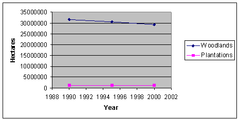
Fig. 1: Temporal changes in plantation and woodlands area from 1986 to 2000
Comparison between global trends and national trends in terms of forest cover change indicates that forest cover has not changed very much over the past 10 years. For example, indigenous forest area showed an annual increase of about 1.9%, woodlands a decline of 3.9% and plantations about 4%. The increase in area of indigenous forest can be attributed to the fact that area less than 10 hectares are now being accounted for in the National Forest Inventory whilst the decrease in the area under woodlands are due to degradation and conversions into other land use.
The extent of woodlands has declined at an annual rate of 230,000 hectares from 1974 to 2000 suggesting total woodland cover change of almost 20% over the same period. The general trends with regards to indigenous and plantation cover has however remained stable. The slight change in the extent of forest cover in South Africa can mainly be attributed to change in the extent of woodlands
Pest and disease data for plantations was obtained through questionnaires. Information on extent and condition of forest was obtained through the National Land Cover Project and the indigenous forest type classification project. Information on infestation and cost to control infestation was obtained through literature review.
National |
1. Condition of natural/woodlands forest canopy |
2. Population structure of target species |
3. Extent and connectivity of natural ecosystems |
4. Rehabilitation of degraded forest |
5. Impacts of pests and diseases |
6. Negative impacts of fire |
7. Infestation by alien invader plants |
8. Soil conservation |
9. Pollution levels |
Regional |
1. Percentage of forest ecosystem with or without regeneration |
2. Trends in yields of forests and agricultural produce |
3. Percentage of forest area encroached by human activities |
4. Percentage of forest ecosystem with or without regeneration |
5. Percentage of the population employed in crop and livestock farming |
Variable |
Source |
Reliability |
Year |
Plant invasive |
Van Wilgen B.W., Richardson D.M., LE Maitre D.C., C. Marais., Magadlela D. 2001. The economic consequences of alien plant invasion: Examples of impacts and approaches to sustainable management in South Africa. Environment, Development and Sustainability 3. 145-168. Kluver Academic Publishers. Netherlands. |
Reliable |
2001 |
Cost of clearing invasive |
http://fred.csir.co.za/plants/global/continen/africa/safrica/bigpic/costclear |
2002 | |
|
Cost of fire |
|||
|
Extent of forest type occurring in protection areas |
Bailey, C.L., Shackleton, CM., Geldenhuys C, J., Moshe D., Fleming G., Vink E.R., Rathogwa N, R., Cawe, S.G. 1999. Guide to and summary of the meta-database pertaining to selected attributes of South African Indigenous Forest and woodlands |
Reliable |
1990 |
|
Extent of natural and woodlands forest by type |
Von Maltitz G. et al. 2003. Classification System for South African Indigenous Forests. CSIR. Environmentek |
Reliable |
2002 |
|
Condition of natural/woodlands forest canopy |
Department of Water Affairs and Forestry. 2003. Unpublished state of the forest report |
Reliable |
2001 |
|
Nutrient cycling |
|||
|
Canopy cover of forest |
Department of Water Affairs and Forestry. 2003. Unpublished state of the forest report |
||
|
State of environment of south Africa |
Table: Extent of natural and woodlands forest by type
|
Type Indigenous Forest31 |
Area in ha |
Type of woodland |
Area protected by State organs |
|
Southern Afrotemperate32 |
80,542 |
High-altitude Acacia |
1,205,132 |
|
Northern Afro temperate |
14,635 |
Low-altitude Acacia |
751,712 |
|
Northern Misbelt |
65,240 |
Kuruman |
9,410 |
|
Southern Misbelt |
114,520 |
Ghaap Plateau |
3,496 |
|
Scarp |
177,237 |
Southern Renosterveld |
4,582 |
|
Northern Coastal |
51,330 |
Waterberg |
267,798 |
|
Southern Coastal |
15,000 |
Low-altitude Combretum |
1,404,760 |
|
Azonal |
|
Soutpansberg |
82,996 |
|
Lowveld riverine |
4,387 |
Spekboom |
84,379 |
|
Swamp |
4,843 |
Northern Succulent |
11,652 |
|
Mangove |
673 |
Southern succulent |
39,160 |
|
Licuati sand forest |
6,000 |
Mopane |
1,121,037 |
|
Total |
534,407 |
Total |
4,986,114 |
Table: Area converted out of timber production by species (in ha)
|
SPECIES |
1990 |
2000 |
|
Softwood |
776 |
4,767 |
|
E. Grandis |
504 |
800 |
|
Other Eucalypts |
2,418 |
n/a |
|
Wattle |
922 |
939 |
|
Other |
133 |
7 |
|
TOTAL |
4,753 |
6,513 |
Table: Area of woodlands degraded and converted to other land use
|
Woodland class |
Degraded |
Converted woodland |
Actual woodland |
Total |
|
High-altitude Acacia |
1,858,908 |
7,554,361 |
10,234,306 |
19,647,575 |
|
Low-altitude Acacia |
470,337 |
2,022,868 |
2,351,012 |
4,844,217 |
|
Kuruman |
2,831 |
548,484 |
752,674 |
1,303,989 |
|
Ghaap Plateau |
81,241 |
94,779 |
2,163,103 |
2,339,123 |
|
Southern Renosterveld |
1,701 |
114,119 |
18,056 |
133,876 |
|
Waterberg |
11,396 |
0 |
1,224,270 |
1,235,666 |
|
Low-altitude Combretum |
1,139,426 |
794,869 |
7,929,347 |
9,863,642 |
|
Soutpansberg |
49,657 |
0 |
429,213 |
478,870 |
|
Spekboom |
57,331 |
718 |
801,883 |
859,932 |
|
Northern Succulent |
202,028 |
567,650 |
521,366 |
1,291,044 |
|
Southern succulent |
82,827 |
324,012 |
552,637 |
959,476 |
|
Mopane |
26,887 |
|
2,324,449 |
2,351,336 |
|
Total |
3,984,570 |
12,021,860 |
29,302,316 |
45,308,746 |
Source: DWAF 2000
Table: Summary table of the status of conditions of indigenous forest by forest group
|
Forest Type |
Condition/Status |
|
Western Cape Talus Forests |
Most patches are protected within nature reserves |
|
W. Cape Afrotemperate |
1. Generally conserved in conjunction with fynbos. |
|
Southern Cape Afrotemperate Forests |
1. Largest portion well protected and managed within a system of strict nature reserves and areas for sustainable exploitation. |
|
Marekele Afrotemperate Forest |
Well preserved |
|
Northern Highveld Forests |
Insufficient data to assess either the extent of use or conservation status. Most of the forest patches are within conservation areas |
|
Drakensberg Montane Forests |
Well preserved in nature reserves of Ezemvelo KZN Wildlife uKhahlamba-Drakensberg Park. |
|
Northern KwaZulu-Natal Mistbelt Forests |
Protected in a number of nature reserves found along the Low Drakensberg and in Ngome N.R. |
|
Northern Mistbelt Forests |
1. Well conserved in the Magoebaskloof under DWAF management and private ownership. 2. Threatened along the North Eastern Escarpment in previous Lebowa areas. 3. Well conserved in the Soutpansberg, excluding areas in communal land where subsistence agriculture and fire wood collection is not controlled. |
|
Mpumalanga Mistbelt Forests |
1. Occur on state land and are protected. 2.Those occurring on private land have been declared Natural Heritage Sites |
Source: DWAF. 2002
Impacts of pests and diseases:
Table: Area of plantations affected by pests and diseases
|
1987 |
1999/00 |
2000/01 |
2001/02 | |
|
Insects |
202 |
41 |
165 |
470 |
|
Diseases |
200 |
51 |
202 |
134 |
Negative impacts of fire:
Table: Number and area of sites negatively affected by fire
|
|
1986/87 |
1999/00 |
2000/01 |
2001/02 |
|
Number of occurrences |
39 |
3,265 |
3,540 |
3,128 |
|
Hectares |
32,037.6 |
2,0221 |
17,266 |
16,727 |
Table: Change in fire protection expenditure
|
1987 |
2000 |
cost of protection | ||||
|
1987 |
2000 | |||||
|
Province |
No of occurrences |
Area in ha |
No of occurrences |
Area in ha |
R/ha |
R/ha |
|
Western cape |
5 |
0.16 |
65 |
1,851 |
0.03 |
94.25 |
|
Southern cape |
17 |
178.61 |
147 |
314 |
3.58 | |
|
Eastern Cape |
13 |
932.02 |
162 |
3,477 |
63.9 | |
|
KwaZulu Natal |
54 |
7.03 |
1,900 |
3,327 |
0.51 |
133.99 |
|
Zululand |
63 |
41 |
254 |
1,342 |
1.06 |
117.47 |
|
Central district |
41 |
230 |
18 |
814 |
3.2 |
103.92 |
|
Mpumalanga |
41 |
92.49 |
850 |
5,464 |
0.62 | |
|
Limpopo |
15 |
9.59 |
125 |
101 |
1.34 |
96.27 |
|
|
249 |
1,490.9 |
3,521 |
16,690 |
|
|
|
Average for South Africa |
4.02 |
108.91 | ||||
Table: Fire Protection Cost: Catchments area
|
1987/86 |
2000 | ||
|
Province |
Area Protected (in ha) |
Cost/ha |
Cost/ha |
|
Western Cape |
717,859 |
0.3 |
No information |
|
Southern Cape |
548,452 |
2.08 |
|
|
Natal |
202,000 |
0.79 |
|
|
Eastern Cape |
38,977 |
2.94 |
|
|
Limpopo |
22,009 |
2.64 |
|
|
Total |
1,529,297 |
0.74 |
|
Infestation by alien invader plants:
Table: Infestation area and stand densities of alien plant invader species
|
Province |
Total area in 000 ha |
Area infested in 000 ha | |
|
1986/87 |
2000 | ||
|
Western Cape |
12,931 |
373 |
3,727 |
|
Eastern Cape |
16,986 |
7 |
671 |
|
KZN |
9,212 |
24 |
922 |
|
Mpumalanga |
7,957 |
23 |
1,277 |
|
Limpopo |
12,214 |
8 |
1,178 |
|
Free State |
12,993 |
|
166,308 |
|
Gauteng |
1,651 |
|
22 |
|
Northern Cape |
36,198 |
|
405 |
|
North West |
11,601 |
|
1,702 |
Source: Plantation, catchments and drift sand
Table: Cost per hectares of controlling invading plants
|
PROVINCE |
Cost of control |
Cost per ha | ||
|
1986 |
2000 |
1986 |
2000 | |
|
RM |
R M |
R/ha |
R/ha | |
|
Western Cape |
0.692 |
2,884 |
1.85 |
773.75 |
|
Eastern Cape |
0.152 |
723.22 |
20.12 |
1076 |
|
KZN |
0.541 |
765.67 |
22.10 |
830.44 |
|
Mpumalanga |
0.28 |
477.75 |
12.06 |
373.88 |
|
Limpopo |
0.059 |
525.58 |
6.75 |
446.03 |
|
Free State |
|
127.03 |
|
763.85 |
|
Gauteng |
|
57.63 |
|
2,610.75 |
|
Northern Cape |
|
1,114.6 |
|
2,751.01 |
|
North West |
|
297.39 |
|
446.03 |
|
Total |
|
6,972.87 |
|
1,119.0822 |
Table: Cost per ha in real prices of controlling invading plants
|
Provinces |
Cost per ha | |
|
1986 |
2000 | |
|
Western Cape |
7.16 |
773.75 |
|
Eastern Cape |
77.92 |
1,076.00 |
|
KZN |
85.59 |
830.44 |
|
Mpumalanga |
46.71 |
373.88 |
|
Limpopo |
26.14 |
446.03 |
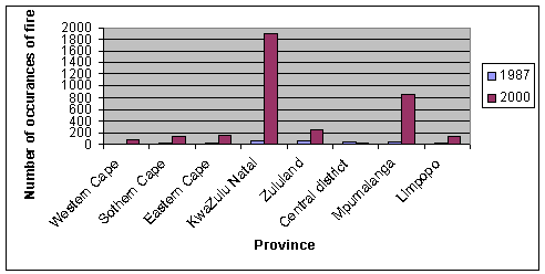
Fig.2: Comparison of number of occurrences of fire by province between 1990 and 2000
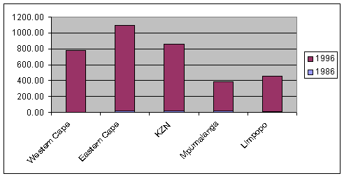
Fig.3: Comparison of cost per hectare of controlling invading plants between 1986 and 2000.
Regional:
No information available for areas of forests and other wooded lands managed for scenic and amenity purpose.
Most of the indigenous forests are well protected, except for a few forests which have been invaded by communities. Woodlands are however, still the most affected ecosystem in South Africa indicating that almost 35% of the total have been converted to other land use or degraded. The National Forest Act (NFA No.84 of 1998) recognises these negative trends and provides the Minister of Water Affairs and Forestry with powers to intervene urgently to prevent deforestation and to rehabilitate deforested areas.
Although the number of occurrences of fire in plantations has increased tremendously from 1986/87 to 2002, the actual total area affected has declined. This can be attributed to an increase in fire protection and conservation investments by the forest industry. The total land area infested by alien invasive though, has increased (by 97%) over the same period with Western Cape Province the most infested. Most plantations were severely affected by insects in 2001 whilst the rate of areas affected by diseases seems to have declined.
Frequency of fire occurrences in plantations were mostly found in the Kwa-Zulu Natal provinces followed by Mpumalanga. Although the number of occurrences was higher in Kwa-Zulu Natal, the actual area damaged was small as compared to Mpumalanga. This may be attributed to several factors, one of which is speedy reaction to fire alarm and the actual investment in forest protection and conservation. No reports on disease and insects effect on indigenous forest are available at national level, whilst there is fluctuation in the number and the area affected by insects and diseases in plantations. Invasive species seem to be a problem, affecting almost 10 million hectares of land in South Africa.
The IUCN red Data List system of categories and criteria were used for the purpose of publishing Southern African Red Data List. The system used consists of eight categories. The placement of taxan in each category was justified according to certain criteria that applied. Bailey et al, 1999, reports that the information on the protection status of the South African woodlands was compiled using the National Register of Protected Areas in South Africa (Wahl & Naudè 1996). Conservation officers in the nine provinces were consulted in the process. Where there were discrepancies, between these two sources, the data from the National Register was used. The National Register of Protected Areas forms part of the national data bank for national conservation planning in South Africa. This database is kept and maintained by the Department of Environmental Affairs and Tourism. When calculating the size of protected areas/reserves within woodlands, certain errors were encountered because the actual area of woodlands in the reserve could not always be determined. This can be attributed to the fact that it was not possible to digitise the exact boundary and locality/position of certain reserves. The ill defined boundary reserves were relatively small compared to the total area for which calculation were done, and as such were excluded. There were a total of 12 such reserves nine of which was found in the Limpopo provinces. This may have resulted in a possible underestimation of the area.
|
National |
|
1. Implementation of forest protection plans |
|
2. State of forest protection |
|
3. Extent of natural and woodlands forest by forest type |
|
4. Extent of forest type occurring in protection areas |
|
5. Presence of specific organism as bio monitoring indicators |
|
6. Status of forest dwelling species at risk of not maintaining viable breeding population |
|
Regional |
|
1. Conservation area outside protected areas |
|
2. Areas lost annually of forest ecosystem containing endemic species |
|
3. Resource exploitation system |
|
4. Average number of provenance |
|
5. Population level of key species across their range |
|
6. Degree of management of genetic resources |
|
National variable |
Source |
Reliability |
Year |
|
IUCN categories of woodlands |
Bailey, C.L., Shackleton, CM., Geldenhuys C, J., Moshe D., Fleming G., Vink E.R., Rathogwa N, R., Cawe, S.G. 1999. Guide to and summary of the meta-database pertaining to selected attributes of South African Indigenous Forest and woodlands |
||
|
Canopy cover of forest |
Department of Water Affairs and Forestry. 2003. Unpublished state of the forest report |
||
|
State of environment of south Africa |
|||
|
Implementation of forest protection plans |
Annual report. 1986/87. Department of Environmental affairs. Government Printer, Pretoria |
Reliable |
|
|
State of forest protection |
ditto |
Reliable |
|
|
Forestry protection cost |
Rusk GD, Pennefather M, Cronje CA, Meyer WK. 1996. Forestry Costs in South Africa. The Green Gold Crop Pietermaritzburg |
Reliable |
Table: Extent of protected indigenous forests and woodlands by type
|
Type Indigenous Forest33 |
Area in ha |
Type of woodland |
Area under Protection by organs of state |
|
Southern Afrotemperate34 |
80,542 |
High-altitude Acacia |
1,205,132 |
|
Northern Afro temperate |
14,635 |
Low-altitude Acacia |
751,712 |
|
Northern Misbelt |
65,240 |
Kuruman |
9,410 |
|
Southern Misbelt |
114,520 |
Ghaap Plateau |
3,496 |
|
Scarp |
177,237 |
Southern Renosterveld |
4,582 |
|
Northern Coastal |
51,330 |
Waterberg |
267,798 |
|
Southern Coastal |
15,000 |
Low-altitude Combretum |
1,404,760 |
|
Azonal |
|
Soutpansberg |
82,996 |
|
Lowveld riverine |
4,387 |
Spekboom |
84,379 |
|
Swamp |
4,843 |
Northern Succulent |
11,652 |
|
Mangove |
673 |
Southern succulent |
39,160 |
|
Licuati sand forest |
6,000 |
Mopane |
1,121,037 |
|
Total |
534,407 |
Total |
4,986,114 |
Implementation of forest protection plans:
Table: Area of forest by type, number of hectares per forest protection person and protection expenditure
|
Area of forests |
Forest protection cost |
||||
|
Forest type |
196/87 |
2000 |
86/87 |
1996 |
% change in Cost of protection |
|
ha |
ha |
R/ha |
R/ha |
||
|
Indigenous forest |
507,496.7 |
533 669 |
0.74 |
? |
|
|
Woodlands |
32,422,15235 |
29,302,316 |
n/a |
n/a |
|
|
Plantation |
261,477.7 |
1,357,760 |
14.99 |
154.71 |
90% |
There is no latest available data on the cost of protection and conservation for woodlands and indigenous forestry, however, the 1986/87annual report by the Department of Environment Affairs indicates the average total cost per hectare for catchments areas as R0.74/ha. This figure also includes declared mountain catchments areas. The cost to protect and conserve plantations increased from R14.99 to R151.74 (90%), between 1987 and 1996, an increase of about 70% in the cost of protection.
Table: Number and type of reported transgressions (by category) in terms of the Environmental Conservation Act, 1982 (Act 100 0f 1982) and National Forest Act No.84 0f 1998
|
Reported transgression |
1986/87 |
2000/01 |
|
EVA 1982 |
NFA 1998 | |
|
Unlawful lighting of fire |
100 |
No national figures |
|
Theft |
65 |
|
|
Trespass |
909 |
|
|
Beer-brewing and illegal liquor sales |
27 |
|
|
Poaching |
21 |
|
|
Assault |
30 |
|
|
Unlawful grazing |
1,265 |
|
|
Malicious damage to property |
17 |
|
|
Littering |
9 |
|
|
Felling of protected trees |
75 |
|
|
Other |
63 |
|
|
Total number of trespasses |
2,581 |
|
|
Total number of prosecutions |
1,638 |
|
|
Total number of convictions |
1,587 |
Reported numbers of transgressions for recent years are collected at Forest Management Units by some regional foresters but have not yet been aggregated at national level to indicate national trends. However, an example of the type and extent of forest transgressions in South Africa was captured in the annual report of 1986/87 in compliance with the requirements of the Environmental Conservation Act (Act 100 of 1982). According to this information, a total of 1 587 transgressions were made in 1987, the highest of which was unlawful grazing. Indications are that this pattern still exists to date. The National Forest Act (NFA no84 of 1998) requires that the number and type of transgressions be reported at national level for the purpose of reporting and policy revision to address negative trends. Some measures that have been taken to address illegal transgression, uses and access are the issuing of licences and exemption for forests goods and services required for commercial and domestic purposes respectively to comply with the requirements of the Act.
Table: Conserved area and number of Red Data book taxa in South African hot-spots
|
Red data book taxa |
Area conserved (%) |
Number Extinct |
Other |
|
Wolkberg |
13.3 |
0 |
32 |
|
Maputaland |
10 |
? |
? |
|
Eastern Mountain |
5.5 |
0 |
27 |
|
Pondoland |
7 |
0 |
33 |
|
Albany |
6.5 |
1 |
51 |
|
Succulent Karoo |
2 |
18 |
978 |
|
Cape: Lowlands mountain |
3 |
29 |
1,406 |
Table: Number of Endemic Tree Species in each Forest Group
|
Forest Group |
Number |
|
Southern Afrotemperate Group |
20 |
|
Northern Afro temperate Group |
3 |
|
Northern Mistbelt Group |
12 |
|
Southern Mistbelt Group |
6 |
|
Scarp Group |
44 |
|
Northern Coastal Group |
0 |
|
Southern Coastal Group |
3 |
|
Total |
88 |
Table: Change in status of taxa in Each Red Data List in South Africa
|
1980* |
1995* |
2002** (taxa) | |
|
Extinct |
39 |
56 |
15 |
|
Endangered |
104 |
241 |
77 |
|
Vulnerable |
165 |
422 |
322 |
|
Rare |
521 |
1,322 |
92 |
|
Indeterminate |
259 |
378 |
334 |
|
Insufficiently known |
805 |
849 |
108 |
|
Total |
1,893 |
3,268 |
948 |
Source:
* Figures from the National Environment
Report.
** Figure from the Southern African Plant Red Data List
(2002).
Table 15: The number of plant species for which national recovery plan is required
|
Category |
1990 |
1995 |
200036 |
% Change |
|
Number of threatened plants |
2,215 |
3,268 |
3,973 |
44% |
|
Number of threatened tree species |
37 |
65 |
72 |
49% |
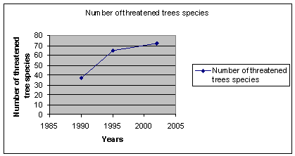
Fig.4: Temporal changes in the number of threatened tree species from 1990 -2002
31
All indigenous forests are legally protected.
32 Same as
above
33 All indigenous
forests are legally protected.
34 Same as above
35 Estimates from Le
Roux (1979).
36
2002 for 2000
