


This section provides information first on the method and approach chosen to identify and assess the complementary national variables and then presents the national data and its assessment including the global variable.
The for identification and assessment of variables, India through FSI used the Group Convergence Method (Govil, 2002). Two workshops were organized one for briefing and explaining and second for implementation of Group Convergence Method to arrive the finalist of identified variables. Temporal trends were developed and GCM was used to assess the state and change in these variables with respect to sustainability of forest resources.
Following national variables in addition to the two global variables (Protective Forests and Protective Other wooded lands) have been identified as complementary national variables that are essential to explain the state of Protective Function of Forests in India.
a. Extent of Forests under Watershed Treatment
b. Status of Forest Soil Fertility
c. Extent of Degraded Forests
d. Ground Water Table in vicinity of Forest
e. Extent of Forest in Hilly Region
f. Extent of Forest in Mangroves
Additional Variable |
Source |
Extent of Forests under Watershed Treatment |
Report of the Working Group on Watershed Development, Rainfed Farming and Natural Resources Management for the Tenth Five Year Plan, Government of India, Planning Commission, August 2001. |
Black, P. E. 1996. Watershed hydrology, second edition. Ann Arbor Press, Chelsea, MI. | |
Status of Forest Soil Fertility |
No national level information is available |
Extent of Degraded forests |
SFR, 1987. State of Forest Resources 1993. Forest Survey of India, Ministry of Environment and Forests, Government of India. |
SFR, 1989. State of Forest Resources 1993. Forest Survey of India, Ministry of Environment and Forests, Government of India. | |
SFR, 1991. State of Forest Resources 1993. Forest Survey of India, Ministry of Environment and Forests, Government of India. |
(follows from previous)
SFR, 1993. State of Forest Resources 1993. Forest Survey of India, Ministry of Environment and Forests, Government of India. | |
SFR, 1995. State of Forest Resources 1995. Forest Survey of India, Ministry of Environment and Forests, Government of India. | |
SFR, 1997. State of Forest Resources, 1997. Forest Survey of India, Ministry of Environment and Forests, Government of India. | |
SFR, 1999. State of Forest Resources, 1999. Forest Survey of India, Ministry of Environment and Forests, Government of India. | |
SFR, 2001. State of Forest Resources, 2001. Forest Survey of India, Ministry of Environment and Forests, Government of India. | |
Ground Water Table in Vicinity of Forests |
Francis Hilary Raj, Mathur, H. N. and Rajagopala, K (1984).Some hydrological investigations on blue gum (Eucalyptus globulus) at Osamund (Nilgiri).Proc: National Seminar on Eucalyptus,Jan-30-31,1984, Kerala Forest Research Institute, Peechi. |
Goel, P.K and Singh H.B (1996). Impact of soil conservation measures on ground water availability. Indian J.Soil Cons., 24(1). | |
Khepar, S.D et al. (2001). Impact of soil and water conservation work on ground water regime in Kandi Area of Punjab. Jr.Soil and Water Conservation , 45(3&4). | |
Mallikarjunappa Gouda, D.S.,Maurya, N. L, Belgami, M.I., Chidanand, P. Mansur and Kubsad,V.S (1992).Impact of water harvesting structures (Nala Band)on ground water recharge.Indian J Soil Cons.,20(3). | |
Extent of Forest In Hilly Region |
SFR, 1995. State of Forest Resources 1995. Forest Survey of India, Ministry of Environment and Forests, Government of India. |
SFR, 1997. State of Forest Resources, 1997. Forest Survey of India, Ministry of Environment and Forests, Government of India. | |
SFR, 1999. State of Forest Resources, 1999. Forest Survey of India, Ministry of Environment and Forests, Government of India. | |
SFR, 2001. State of Forest Resources, 2001. Forest Survey of India, Ministry of Environment and Forests, Government of India. | |
Extent of Forest in Mangroves |
SFR, 1987. State of Forest Resources 1993. Forest Survey of India, Ministry of Environment and Forests, Government of India. |
SFR, 1989. State of Forest Resources 1993. Forest Survey of India, Ministry of Environment and Forests, Government of India. | |
SFR, 1991. State of Forest Resources 1993. Forest Survey of India, Ministry of Environment and Forests, Government of India. | |
SFR, 1993. State of Forest Resources 1993. Forest Survey of India, Ministry of Environment and Forests, Government of India. | |
SFR, 1995. State of Forest Resources 1995. Forest Survey of India, Ministry of Environment and Forests, Government of India. | |
SFR, 1997. State of Forest Resources, 1997. Forest Survey of India, Ministry of Environment and Forests, Government of India. | |
SFR, 1999. State of Forest Resources, 1999. Forest Survey of India, Ministry of Environment and Forests, Government of India. | |
SFR, 2001. State of Forest Resources, 2001. Forest Survey of India, Ministry of Environment and Forests, Government of India. |
This section provides information on each of the identified additional variables. It contains relevant definitions, source and source data, temporal trends and its assessment.
Treatment of watershed areas helps to maintain its hydrological regime and includes conservation and development of forest areas. Treatment spans activities like control measures for soil and water erosion and controlled access or disturbances to fragile areas. The Extent of Forest under such Treatment of watersheds is an important variable to monitor protective services of forests.
Definition (No standard definition available)
Term |
Definition |
Watershed |
A watershed is an area in which the natural hydrological boundaries drain to a common point on a watercourse, usually a confluence of streams or rivers (also known as drainage area or, catchment). |
Treatment (Management) |
The planned manipulation of one or more factors of the natural or disturbed drainage so as to effect a desired change in or maintain a desired condition of the water resource. (Black, 1996) |
Transformation Not needed
Data and Temporal Trends
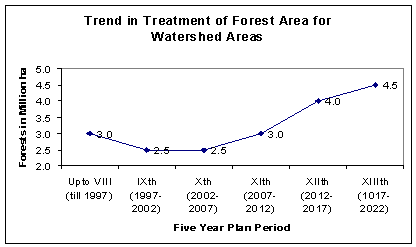
Following figure indicates the magnitude of treatment in successive Five Year Plans including level of the activity proposed for future plans.
Assessment
The temporal trend indicates increasing commitment of government to address the issue of protection to watershed areas.
Forests protects and contribute to soil fertility. Monitoring of the trend of soil fertility or the productive potential of forest soils is necessary to measure the trend in capacity of the forest to provide necessary protection and conservation to soil resources. In other words it is a direct measure of one of the protective function of the forests.
Definition: (Not standard national definition is available)
Term |
Definition |
Forest Soil Fertility |
The forest productive capacity of a soil. Explanation: It depends on those factors in the soil that determine its crop production potential. Such factors are the presence of essential plant nutrients in available form and in a suitable balance; the proper micro-biological status of the soil to provide healthy environment for the release of plant nutrients; and freedom from any toxic or injurious agents, conditions or substances in the soil. |
Transformation Not needed
Data and Temporal trend
The fertility of forest soil is normally measured through the level of N, P and K as well as Ph of soil and is well documented. Although forest soils in India have been studied in detail but they are mostly one time period studies and do not provide information on temporal trend.
Assessment
Assessment is not possible due to lack of data. It is suggested that temporal data on this variable be collected to monitor the fertility level at regular interval of time. It will facilitate in time diagnosis of start of any degradation process, such conditions may be indicated by lower levels of availability of N, P, and K , and or with large changes in Ph. of soil (taking it to very high or very low values) .
Healthy forests are necessary to maintain their protective flows. Over use, misuse, and or unscientific use of forests leads to transformation of forest into degraded forests. Monitoring of extent of degraded forest is important because increases in area of degraded forest provide direct indication of loss in the protective flows from forests.
Definition (Not standard national definition is available)
Term |
Definition |
Degraded Forest |
Forest with its reduced capacity to provide goods and services. |
Transformation Not needed
Data and Temporal Trend
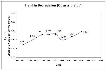
The Open forests and scrub forest may exist either due to ecological conditions or due to degradation of dense forests. To distinguish between the two processes, it may be assumed that changes in open and scrub forests over small periods of time like two years of biannual survey of FSI may be due to improvement or degradation in forests and not due to ecological changes. FSI uses the ratio ( a unit and scale free dimension) of open and scrub forests to dense forest to develop trends because it is difficult to compare data over time when it comes from different resolutions and scale, as in case of data on forest cover.
Assessment
The temporal trend indicates an increase trend in degradation of forests which is not a good sign for the forest resources of the country.
Forest affect and get affected by the ground water regime. Ground water resources in India are depleting at very fast rate and the condition is like to worsen in future with increase in by 50% over the next 20 yrs. Monitoring of ground water in areas near to forest is therefore very important for ensuring sustainability of forest resource.
Definition (No standard national definition is available)
Term |
Definition |
Ground Water |
All subsurface water that fills the pores, voids, fractures, and other spaces between soil particles and in rock strata in the saturated zone of geologic formations. (http://ohioline.osu.edu/aex-fact/0460.html) |
Water Table |
The surface of the body of unconfined ground water where the hydrostatic pressure is equal to atmospheric pressure. The water table is the boundary between the saturated and unsaturated zones and fluctuates according to season and rainfall. (http://oaspub.epa.gov/trs/trs_proc_qry.alphabet) |
Water level |
The water-surface elevation or stage of the free surface of a body of water above or below any datum, or the surface of water standing in a well, usually indicative of the position of the water table or other potentiometric surface. (http://ohioline.osu.edu/aex-fact/0460.html) |
Transformation Not necessary as data is not available
Data and Temporal Trend
Necessary and sufficient information on this variable is not available therefore it is difficult to develop temporal trends.
Assessment
No assessment is possible as national level information on this variable is not available. However, there is a public consensus based on local studies that level of ground water in India has an overall declining temporal trend.
The variable helps to understand the existence of protective forest cover to conserve soil and water regimes in hill regions which are fragile landscapes of India. The monitoring of forest cover in hills is important for long term sustainability of hilly landscapes.
Definition
Term |
Definition |
Hilly Region |
A region above 500 meter altitude |
Transformation Not needed
Data and Temporal Trend
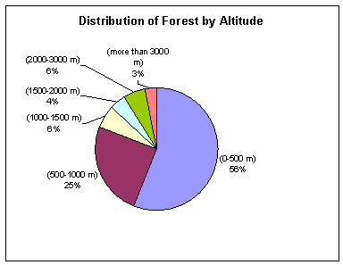
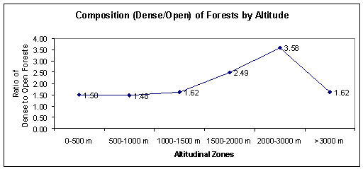
The Himalayan eco-system is a fragile ecosystem and its fragility increases with altitudes. FSI has digitized 500 M contours and identified the following distribution as well as composition (ratio of dense forest to open) of forests by altitude zones.
Assessment
The temporal trend in last three assessments relating to data period of 1994, 1997 and 2000 indicates that forest cover in the hilly region of India is roughly constant at 37 percent, which is a good indication for sustainability of the forest resources in the hilly regions of India.
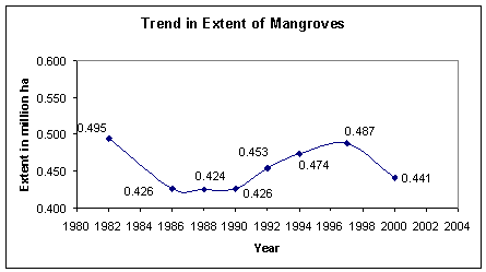
Mangrove forests are bio-diverse wetland forest ecosystems with muddy substratum of varying depth for their growth. They protect coastal area by checking soil erosion from tidal action of waves, strong winds and cyclone and also support livelihood of local people.
Definition
Term |
Definition |
Mangroves |
Salt tolerant forest ecosystem found mainly in tropical and sub- tropical coastal and/or inter-tidal regions. |
Mangrove Cover |
Area covered under mangrove vegetation as interpreted digitally from remote sensing data. It is classified into dense mangrove cover (canopy density over 40 percent) and open mangrove cover (canopy density from 10 to 40 percent). |
Transformation Not needed
Data and Temporal Trends
Expect for periodic survey by FSI, there are very few studies on Mangroves in India. Following figure presents the extent of mangroves in India based on biannual surveys by FSI.
Assessment
One of the many explanations for the above temporal changes is that it is mainly due to change in resolution of satellite imageries and increase in scale of interpretation. It means that its area has increased because small additional patches of mangrove could be identified and its area has decreased because small patches of non-mangrove areas were detected within earlier demarcated mangrove areas. Therefore, it may be better to treat these changes as fluctuations and not a trend.
