![]()
![]()
By Mr. IVAN KATAVIC,
PRIORITY ACTION PROGRAMME REGIONAL REGIONAL ACTIVITY CENTER
1. MEDITERRANEAN ACTION PLAN: A COMMON EFFORT
Adverse effects of the concentrations of people along the coast and their activities on fragile coastal ecosystem s have become a world problem. This is however particularly true for the regional seas such as the Mediterranean in which geomorphological characteristics do not allow the regeneration of the ecosystems at a pace required by the intensity of human activities along the coast. The resulting processes which have led to irrevocable degradation of the Mediterranean forced the Mediterranean countries sharing the problem to launch an action plan for urgent interventions where there are imminent dangers, but also to create favourable conditions on a long run to reverse negative trends and eliminate causes of dangers.
However , the final impulse to the creation of the Mediterranean Action Plan (MAP) came from the Stockholm Conference of the United Nations held in 1972 under the title «Only One Earth ». The Conference adopted the Action Plan of the United Nations for Human Environment. Following this Plan, General Assembly of the United Nations decided to establish the United Nations Environment Programme (UNEP) which was to have a catalytic and coordination role in the protection and enhancement of the environment, departing from the basic principle that it could and should be achieved primarily through a rational development and optimum use of resources, by a permanent monitoring of the state of the environment and by improving knowledge about the processes in ecosystems. In developing its programme, UNEP has given priority to the oceans and regional seas and established a special Programme of Regional Seas. Today, the Programme covers the protection of 10 regional seas through the cooperation of coastal stales, with the support of UNEP, other specialized agencies of the UN system and other international and non-governmental organizations.
The Mediterranean, being one of the regional seas, became the first regional programme of UNEP, with the cooperation of 17 out of 18 Mediterranean countries, and the European Community, the Mediterranean Action plan was born, its legal framework being the Convention on the Protection of the Mediterranean sea against pollution, which was signed in Barcelone in 1976 and came into force in 1978. These Convention is proof enough that the Mediterranean countries were and are ready to put aside their differences and join in a common effort to protect their sea. Structurally, MAP consists of the following components:
legal, which includes a series of legally-binding treaties to be drawn up and signed by Mediterranean countries;
scientific, which includes creation of a pollution monitoring and research network, and
socio-economic within which a programme has been drawn up that would reconcile vital development priorities with a healthy Mediterranean environment.
On this basic structure lies the organization of MAP (Figure 1) which, in addition to the coordinating Unit (MEDU) in Athens, includes five regional activity centres;
- MEDPOL (Athens Greece) is a comprehensive long-term monitoring and research programme which is also in charge of the Protocol dealing with pollution from land-based sources.
- Blue Plan (Sophia Antipolis, France) - BP is a programme which explores the long-term evolution of the relationship between development and the environment in the Mediterranean. Its most important function is to come up with a set of realistic scenarios for sustainable, integrated social and economic development of the Mediterranean region.
- Priority Actions Programme (Split Yugoslavia) - PAP is carrying out practical actions which are expected to yield immediate results. Its aim is to contribute through the exchange of available experience and cooperation among enhancement of Mediterranean environment, to the strenghening of national and local capacities for planning and management of coastal zones, and to the alleviation of the existing socio-economic inequalities among integrated planning and management of coastal zones which is being implemented in coastal area management programme s (CAMPs) in a number of Mediterranean countries.
- Regional Oil-Combating Centre (Manoel Island Malta) - ROCC assists in the formulation of national and sub-regional oil-pollution contingency plan, providing training in oil pollution control and, in cases of emergency, helping to coordinate the technical response of governments to accidents.
- Specially Protected Areas (Tunis Tunisia) - SPA, assists the governments in applying the Protocol concerning Mediterranean Specially Protected Areas. The Protocol provides special protection to endangered Mediterranean animals and plants as well as whole areas considered vital to their survival.
2 SOCIO-ECONOMIC COMPONENT OF MAP: DEVELOPMENT HARMONIZED WITH ENVIRONMENT.
Interaction between human efforts to improve the well-being and the capacities of environment to sustain these efforts continuously appears throughout the human history, However, in recent times these interactions have risen beyond the level of comparatively simple and narrow local phenomena.In the Mediterranean basin too, the increasing degradation of the environment frequently extends beyond the local and national borders. Of course, studying this phenomenon (environment degradation) without going deep into its causes (development activities) can bear short-term results only. Understanding of development and environment as a single process has become the rationale and philosophy of the Mediterranean Action Plan. Dr.Mostafa K.Tolba, Executive Director of UNEP, gave a substantial support to such an understanding in his paper on the preliminary ideas on refocusing of MAP activities on evironmentally sound integrated planning and management «…. formulation of macro-economic policies must take into account from their conceptual stage, the net impact of such policies on enviromental quality and the national resources base (…) just as environment policies, from their conception, must take account of the potential impact on the management and planning of coastal zone development, tourism, etc… Their output, incentive system and profits» (1988).
The socio-economic component of MAP is being implemented through the activities of two centres and, it may be stated, on two levels :
The Blue Plan is a programme of prospective studies, using scenario methods related to development-environment interrelations with the years 2000 and 2025 as time horizons, with the objective of providing inputs to global (Mediterranean), development, planning and management.
The Priority Actions Programme is an active-oriented programme within which concrete tasks in individual countries of the Mediterranean region are materialized on the basis of an integrated appoach to coastal zone planning.
UNITED CONFERENCE ON THE ENVIRONMENT STOCHOLM 1972
↓
UNITED NATIONS ENVIRONMENT PROGRAMME UNEP 1972
↓
CONVENTION FOR THE PROTECTION OF THE MEDITERRANEAN SEA AGAINST POLLUTION BARCELONA 1975–1976
↓
MEDITERRANEAN ACTION PLAN - MAP
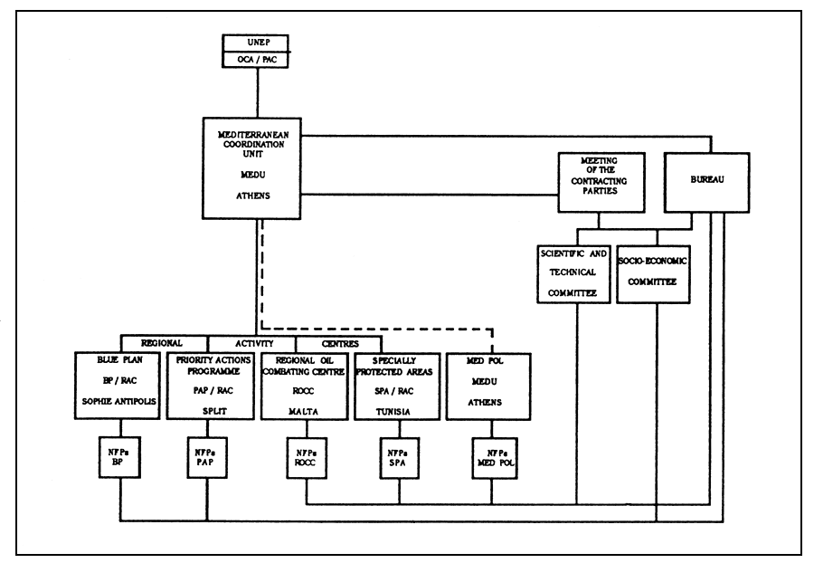
Figure 1 : Mediterranean Action Plan - organizational chart
Regardless of the «macro» and the «micro» level of activities carried out in these two centres, there is a notable complementarity of their «outputs» : The Blue Plan provides the global guidelines of socio-economic development and impacts of development on the environment in the Mediterranean region while PAP tests them on practical cases (CAMPs). Further is a brief description of the organization of PAP, its integrated approach to coastal zone planning, and CAMPs on which this approach is tested.
3 THE PRIORITY ACTIONS PROGRAMME : PRACTICAL APPROACH TO ENVIRONMENTAL PROBLEMS :
PAP is not a research programme. Through a network of institutions and experts, it uses the knowledge and experience existing in the Mediterranean countries for launching immediate actions in individual countries of the region.

Figure 2 : Priority Actions Programme - organizational chart
PAP has geared its effort towards the harmonization of activities and cooperation with relevant agencies of the UN system, and with other competent and interested international organizations. As a result, PAP succeeded in establishing cooperation with ALECSO, FAO, UNESCO, UNDRO, UNCHS, UNIDO, WHO, WTO, the World Bank, and with about 50 Mediterranean and other international institutions. PAP is carrying into effect its activities through a network of more than 350 Mediterranean experts officially nominated by their respective governments.
The activity of PAP covers 6 priority fields selected and agreed upon by the Contracting parties to the Barcelone Convention. Those are:
- water resources;
- human settlements;
- soil protection;
- tourism;
- aquaculture;
- renewable sources of energy.
Within these priority fields, PAP is conducting 10 priority actions :
Water resources management in the islands and isolated coastal areas;
integrated planning and management of coastal areas;
rehabilitation and reconstruction of the historic settlements;
land use planning in earthquake zones;
solid and liquid waste mangenent;
soil erosion and protection;
development of tourism harmonized with the environment;
environmental approach to aquaculture development;
application of renewable sources of energy;
environmental impact assessment.
In the course of the Programme efforts, apart from various specific issues, a common 3-phase methodological approach crystallized in the implementation of each priority action. The first phase regularly covers fact finding and identification of possibilities for the exchange of experience through national reports, synthesis reports, meetings of Mediterranean experts, and seminars. The second phase is dedicated to in-depth studies, organization of seminars and workshops for the exchange of so obtained experience. The third phase refer to the implementation through direct exchange of experience and cooperation on specific and selected subjects through concrete studies and projects, through workshops, preparation of manuals and guidelines, and through training. A specific form of Mediterranean multilateral cooperation. Such a methodological concept has been supported by a systematic approach, a satisfactory geografic representation of participating countries, and a gradual advancement in work. The general methodological approach to each priority action is shown in Figure 3.
By the end of 1987, all the priority actions became fully fledged. National reports and a number of selected case studies commissioned in the frame of each priority action were completed and evaluated at respective meetings, seminars and workshops. Responding to the request of interested countries, a number of expert missions were envoyed to assist and work with local institutions in resolving problems of specific interest. Particular effort was employed in setting up professional and methodological basis in each priority action for merging and interlinking the obtained knowledge within the process of integrated planning and management of coastal areas.
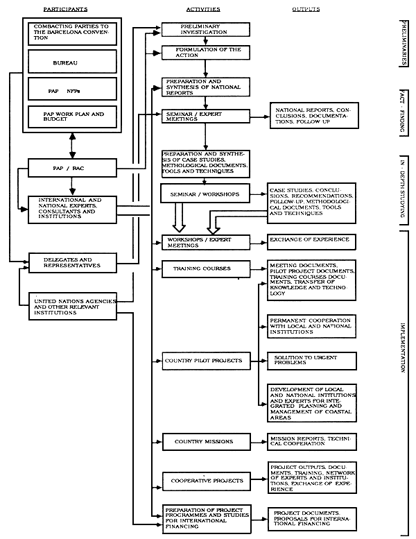
Figure 3: Priority Actions - methodological approach
4 INTEGRATED PLANNING : A TOOL FOR AN ENVIRONMENTALLY SOUND MANAGEMENT OF MEDITERRANEAN COASTAL AREAS
MAP is gradually orienting its activities towards the integrated planning and management of the resources of the Mediterranean coastal areas. This refocusing of the activities corresponds to the decision of the Intergovernmental Meeting on the Protection of the Mediterranean (Barcelona, January 28 – February 4, 1975) to include the «integrated planning of the development an management of the resources of the Mediterranean basin» as one of the central objectives and cornerstones of the MAP.
Most of MAP's past activity has been focused on the monitoring of the state of the sea and interventions aimed at improving the state of the natural systems. The emerging understanding that the sources of problems are mostly land-based has led to refocusing MAP on activities carried out in coastal zones. Harmonization of global development with receptive capacity of the environment calls for a rational management of resources as its practical application. This is need is based on the awareness that the Mediterranean resources are limited, the natural systems fragile, development pressures exceptionally high and that there is a significant interdependence between all these components. They make the basic constituents of the integrated approach to planning and management of coastal areas.
Understanding that the protection and enhancement of coastal areas and their environment can be achieved only through a rational development which uses integrated planning as its major tool, PAP has placed a special emphasis upon its priority action «Integrated planning and management of the Mediterranean coastal areas».
Experience gained in this action has resulted from analysed and synthetised national reports obtained from 13 Mediterranean countries, from a dozen selected case studies, and a number of methodological studies.
The collected information indicates that in majority of Mediterranean countries the integrated planning process in coastal zones has not fully been applied. Modern techniques and methods as tools of integrated planning have not yet been fully utilized. A large part of the coastal strip calls for proper development and management plans, where as the majority of completed plans deal with the coastal zones alone without taking into account the atmosphere, the adjacent marine areas(sea use), and the hinterland.
The existing state of planning and management of Mediterranean coastal areas has called for an attempt at creating a common methodological basis for integrated planning applicable in the Mediterranean countries regardless of their different social and economic conditions of development. A document «Common Methodological Framework for Integrated Planning and Management in Mediterranean Coastal Areas» has been prepared.
It was meant to be a platform for a concerted action of the Mediterranean countries with the aim of establishing such a planning process which would make possible the harmonization of development objectives with the imperatives of an optimal use of resources. However, this document has been designed as a methodological«umbrella» of the integrated planning process which is, due to differences, specificities and needs of Mediterranean region, in its initial phase of definition. In the present moment, preparing a document of a more detailed level of elaborating(such as, for example, guidelines or a manual) would be an overambitious aim. It necessarily stays with a general explanation of the integrated planning process without going deeper into explaining the scope of its individual components. This level of elaboration would enable an easy understanding of the essence of the process, as well as the possibilities of its flexible application, adjustment or extension in specific Mediterranean situations and environments.
The integrated planning is a step forward in relation to the hitherto predominant types of planning. Contrary to the sectorial planning, such as separate economic, social an physical planning, the integrated planning strives for analytical understanding and establishment of interrelations and coordination among major development components. This secures a comprehensive coverage of a whole range of human activities in a given area.
The integrated planning is expected to provide a consistent and long-term framework for achieving a wished-for structure of the area's development which will be capable of incorporating and integrating economic, social, spatial and environmental components. At the same time, it should (a) provide instruments for achieving the inner balance in terms of location and distribution of activities, population, physical and social infrastructure while conserving, to the highest possible degree, the natural environment, and (b) offer a rationale for setting up a permanent environmentally sound management of the area's resources.
The character of integrated planning is process-and action-oriented.
The process-oriented character of integrated planning means that the preparation of an ultimate product-plan, as an ideal state which is to be reached in a certain future time, should not be its objective. Rather, the planning activities to be continuously carried out with the aim of achieving a permanent and environmentally sound management of all resources in a given area. This process incorporated several phases, namely, evaluation of the existing state and trends; formulation of goals and objectives; definition of the planning strategy, detailed proposals and policies; assessment of plan feasability and implementation; monitoring and control over plan implementation.
Continuity of planning implies a cyclic repetition of these phases or modification of planning solutions should the monitoring register changes of the conditions which necessitated these solution to have been of flexibility which is crucial for a realistic planning. Needless to say, the development strategy planning process calls for a corresponding organizational and institutional structure.
The action-oriented character of integrated planning stems from its concern being focused on the most critical problems of the planning area (identified in the initial stages of planning), and on their resolution effectuated through specific projects which should start off as soon as their organization and financial support are secured.
5 COASTAL AREA MANAGEMENT PROGRAMMES: PROBLEM-SOLVING ACTIVITES
Coastal Area Management Programmes (CAMPs) present a new form of advanced collaboration of PAP and MAP with national and local institutions and experts aimed at creating conditions for introducing or developing the process of integrated planning and environmentally sound management of Mediterranean coastal zones.
PAP has chosen the«bottom-up» approach to inauguration of the integrated planning process in the Mediterranean region. Namely, following the analysis of the state of integrated planning in the Mediterranean countries, a document was prepared which defines the basic principles of integrated planning («A Common Methodological Framework for Integrated Planning and Management of Mediterranean Coastal Areas»), and then a selection was made of areas suitable as pilot zones which had been proposed by the Mediterranean countries; Areas suitable for installing CAMPs have to be specific in terms of development problems and their impact on the state of environment, and there must be a need expressed for a short-and long-term solution of these problems. At the same time, these areas have to be typical so that the experience in resolving the problem faced there could be used in the entire Mediterranean coastal zone. It is essential that the countries confirm their interest in launching CAMPs on their respective territories, and to allow further dissemination of crucial and typical outputs arrived at through the programmes.
CAMPs have been broken into: (a) preparatory phase (collection of data, information on the state of problems, acquisition of knowledge on national co-financing, formulation of a consistant programme); (b) programme implementation (preparation of interim planning documents, immediate recovery proposals, setting up of database, training of local experts in methodologies, tools and techniques of integrated planning, preparation of EIAs hazard assessment and risk management studies, preparation of coastal zone scenarios, and preparation of an integrated plan proposal): and (c) follow up focusing on the management problems and, eventually, launching of the integrated plan.
It is clear that a programme such as PAP cannot meet such an ambitious goal. This is why cooperation with local authorities, institutions, experts and general public of the Mediterranean region becomes an imperative objective.
Among the reasons why the cooperation with local experts and institutions is essential, the following should be pointed out:
- Local experts are frequently the most competent persons for identifying the current problems of the project area. By making use of their knowledge the time otherwise needed for the analytical phases of the plan is considerably reduced.
- Involvement of local experts from the outset secure the planning to continue after PAP and MAP specialists have left the project area.
- Training of local experts either in planning tools or techniques is thus provided at a relatively low cost.
In carrying out CAMPs, the role of PAP and MAP (the centres which have developed a large network of relevant activities, institutions and experts) is primarily catalytic. While keeping in mind that their financial resources are limited and hardly sufficient for an all-inclusive inauguration of the process of integrated planning the management of resources in Mediterranean coastal areas, it should be emphasized that these programmes are still capable of assisting in the creation of a solid basis for further larger interventions. Their catalytic role lies in(a) galvanizing interest of local as well as national authorities, institutions and expert in cooperation; (b) making international knowledge and technologies available; (c) procuring necessary support for expertise, training and minimum equipment which some countries are not capable of providing due to unfavourable balance of payments; (d) introducing techniques and tools for environmentally sound management; (e) cooperating with international funding institutions; (f) accentuating problems of an area by placing them in a wider national and international context; and (g) generally, promoting the environmental awareness.
The activities of PAP and MAP cover a whole set of diverse development-versus-environment problems which may appear in selected areas. A substantive contribution of PAP may relate to the use of experience gained in the frame of its priority actions. Inputs of other MAP components (MEDPOL, LBS, Blue Plan, ROCC and SPA) can be also provided. In accordance with their possibilities, PAP and MAP will secure the application of international knowledge through the involvement of international experts, training of national experts and representatives in other countries, provision of necessary minimum equipment for use over the duration of projects, cooperation in the formulation of proposals for international financial support, etc.
CAMPs are expected to yield the following outputs:
- a permanent cooperation of local and national institutions will be developed with Mediterranean experts and institutions as well as with international organizations using primarily integrated planning as a tool, this cooperation will be focussed on the establishment of an environmentally sound management of resources;
- answers to some priority issues of a CAMP will be given within a relatively short time;
- in the conditions of stringent finances which is the problem common to PAP, MAP and the countries of the region, analysis of existing problems and solutions to urgent ones, preliminary studies for integrated plans, programme proposals, etc…, will be obtained at a relatively low cost, as well as a sound basis for seeking international financial support for follow-up activities;
- introducing PAP/MAP experiences in selected areas will be a practical test of gained kowledge;
- local experts will be trained and institutions prepared to become the core of a future permanent cooperation in the system of integrated planning and environmentally sound management on the local, national, and finally, international level.
Pap and Map started off in 1988 with the site-specific CAMPs in Turkey (the Bay of Izmir), Syria (the entire coastal zone), Yugoslavia (the Kastela Ba) and Greece (the insland of Rhodes). The project with Tunisia and Egypt are in the process of defining.
A brief summary will be given for the projects which have started in 1988.
«The Kastela Bay» CAMP. This project is intended as a contribution to the national project «Rational Management of Natural Resources of the Kastela Bay-Yugoslavia». The project has been developed and implemented by the University of Split, in cooperation with the Yugoslav Academy of Arts and Science, and with support by local, republic and federal funds. A part of financing is provided by EEC and the World Bank. The project is wide reaching participation of a large number of reputed national institutions. The project covers wider areas of the towns of Split, Trogir, Solin and Omis located on the Adriatic coast, with the surface area of approximatively 1500 Km2 and 350,000 inhabitants. The coastal area is mostly urbanized with the addition of numerous industries and with a well developed tourism on its outskirts. Due to the spreading of town and development of industry, as well as discharging of only primarily treated wastewaters, the Kastela Bay is very polluted with frequent euthrophication in its easternmost part.
PAP cooperation with the project regards the assessment of the assimilative capacity of the bay, definition of criteria for quality and model of discharging treated wastewaters, training on an preparation of a parts of GIS on PC hardware using ARC/INFO software, preparation of a pilot EIA and pilot study on risk assessment and management, and creation of the basis for dynamic coast inventory. implementation of the PAP part started in 1988 and should end in 1992.
«The Izmir Bay» CAMP. This project contains a number of parallel on-going national and internationally supported projects regarding the monitoring of the state of the bay, oceanographic studies, project of urban wastewaters collection, treatment and discharging, and the recovering of the Inner Bay which is largely eutrophicated. The project covers the area of the Metropolitan Municipality of Izmir, located around the Bay of Izmir in the Aegean Region of the Western Coast of Turkey. The population amounts to approximatively 1,6 Million with a tendency of constant growth (448 annually) so that it is estimated at 2.5 Million in the year 2000. The city is a strong into the bay without any treatment. Tourist activity is intensive in the surrounding area. The national and local authorities have been making great efforts to improve that state.
The PAP input regards the cooperation in the harmonization of the on-going projects into a single project, preparation and implementation of the project of recovery of the Inner Bay, training of local experts and the preparation of an interim study of the integrated plan, preparation of an EIA for sewerage system and discharge of treated wastewaters in the bay, and training on and preparation of a part of GIS using PC-ARC/INFO. The implementation of the PAP part started in 1988 and should be completed in 1992.
«The Syrian Coastal Region». This project has been prepared by PAP in cooperation with the Syrian authorities (Ministries of Environment, Planning and Tourism). It covers the entire watershed of the Syrian coast with the length of 183 kms, and the population amounting to 1.3 million. It is a zone rich with natural resources, and with significant development potential. There is a number of large towns (Lattakai, Tartous, Banyas) where the industry is concentrated,. The coast has all the prerequisites for a strong development of tourism. The towns and industries cause environmental pollution, especially of the adjacent sea.
Since this area has not so far been covered by plans at a regional level, the project has been conceived so as to prepare, on the basis of available information, an interim study for the entire area, which should serve as the basis for the preparation of an integrated plan. The study will follow the methodological framework for integrated planning and, among others, it has to provide the assessment of the state of the environment, proposals of immediate measures for the recovery of the threatened areas and elimination of critical sources of pollution, proposals of possible models of development, and the proposal of the land use of the immediate coastal area.
The draft of the study is finished and upon editing will be submitted to the Syrian Government for clearance. After this study, the plan of protection and management of the coastal strip will be prepared.
The project also envisages the preparation of a pilot EIA, training on and the preparation of a part of GIS using PC ARC/INFO, survey of pollution of the coastal sea (MEDPOL), definition of the specially protected areas, and proposal of protection measures (SPA). The implementation of the project started in 1988 and is expected to be completed by the end of 1991.
«The Island of Rhodes» CAMP. This project was conceived as a MAP project, which means that it envisaged the inputs by all MAP components from the very start of the activities. The project covers the Greek island of Rhodes, situated in the south-eastern corner of the Aegean Archipelago at a short distance from Asia Minor. The island covers an area of 1400 km2 and has about 90 000 inhabitants. International tourism is the principal activity in the island. Besides the historic town of Rhodes, there are many other historic settlements and archaeological sites in the island. The booming development of tourism is a threat with regard to the pollution of air, beaches and the coast. It also causes the problems of water supply and the management of water ressources of the island. Other prominent problems regard the discharge or treated wastewaters, solid waster disposal, and protection of historic heritage.
In its first phase, the project will attempt to concentrate on specific problems related to surveying sea pollution, water ressources management, solid protection of historic heritage.
In the second phase, training on and preparation of a part of GIS and of an interim study for the integrated plan of the island is envisaged. The ultimate objective of the project is to prepare a proposal of the integrated plan and to create conditions for the preparation of the plan. The implementation of the project started in 1980, and is expected to be completed by the end of 1992.
6 CONCLUSION: A BETTER MEDITERRANEAN
MAP and PAP, the important rings in the chain of activities which are an expression of the common aspirations of the Mediterranean countries to leave to their future generation the sea-a legacy if not undamaged and perfectly clean then at least in not a worse state than it is now-have fully appreciated the importance of understanding the processes taking place on land but seriously affecting the sea. In these activities integrated planning has a crucial role as a tool for upgrading the resource management. That is the reason why all MAP activities have been refocused on integrated planning; PAP has been led by this idea from the very begining.
Currently, all this is being tested in practice and it is hoped the results will prove that we have chosen the right way. Of course, neither MAP nor PAP alone are capable of providing better conditions of living for the future generations. Without cooperation of the Mediterranean countries, in which MAP and PAP have a catalytic role, it is hardly possible to achieve much. Finally, mentioning this particular event in Sabha should not be omitted as it surely adds to the promotion of environmental awareness and to the achievement of our common goal-a better Mediterranean.
By Mr. MICHAEL NEW
FAO
SUMMARY OF PRESENTATION
THE ASEAN AQUACULTURE DEVELOPMENT AND COORDINATION PROGRAMME
(AADCP)
AADCP is part of the EC development aid programme in ASEAN. The concept, which is novel in aquaculture development, involves the twinning of pairs of institutes (one EC, one ASEAN) with complementary experience and interests in aquaculture research, training and extension and information exchange. Although networking is a term which has never been applied to the project it is, in fact, operating as a network which involves institutes in both developed and developing nations.
The Participants in AADCP are 6 institutes in ASEAN, 2 in the Philippine and 3 in the E.C. ASEAN institutes are government stations controlled by the Department of Fisheries while, in the EC, 2 institutes are universities and one a government research organization. Brunei Dorussaleaw does not have a participating institute but individual (as also from outside the participating institutes in the other ASEAN countries) can also training courses and workshops and the project can provide consultants to all ASEAN nations.
Although the aquaculture of the EC and ASEAN would at first seem very different in character, particularly in terms of climate, species cultured, and techniques employed there are some interesting similarities in other respects:
| ASEAN (6) | EC (12) | |
| POPULATION (1990) | 324 Million | 347 Million |
| AQUACULTURE PRODUCTION (1989) | 1.0 MILLION mt | 0.9 Million mt |
| PER CAPITA ANNUAL FISH CONSUMPTION | 20 Kg | 20 Kg |
In addition, all the EC institutes have other interest in aquaculture in developing countries, ASEAN and EC are significant trading partners, and there are quite a few ASEAN-EC joint Ventures in aquaculture. The project exposes EC scientists to working with tropical species in the tropics and ASEAN scientists to EC aquaculture research and technology. The project also provides a tropical-tropical interface between ASEAN and EC aquaculture in the sense that one component twins Tahiti as well as metropolitan France with Singapore.
The donor budget for the five year life of the project, ending in December 1994, is ECU 6.77 Million (approximately US $ 8.93 Million). Host funds, mainly in kind, are ECU 3.66 Million (US $ 4.75 Million). The AADCP is the largest regional project in S.E Asia and one of the few fisheries projects supported. Most EC development aid support and fisheries goes to the Lomé countries, specifically in Africa.
The activities of the AADCP include:
- staff exchange both between ASEAN and EC (two-way) and within ASEAN itself. This is an extremely significant feature of the project (27 m/m);
- provision of equipment to ASEAN institutes (US $ 1.8 Million);
- 9 postgraduate fellowships for ASEAN Nationals;
- 10 workshops - 5 in EC, 5 in ASEAN;
- more than 500 m/m of training courses;
- joint research;
- 280 m/m of technical assistance from the participating EC institutes, consultants, and project coodination staff;
- dissemination of information.
Each pair of institutes is concerned with a different aspects of aquaculture development:
| 1. | Indonesia - France | : | brackishwater aquaculture, site selection technology and monitoring of impact; |
| 2. | Malaysia - Netherlands | : | increasing production from lakes and reservoirs through fisheries and aquaculture; |
| 3. | Philippines - France | : | training and technology, verification and packaging in freshwater and brackishwater aquaculture; |
| 4. | Singapore - France | : | research in marine fish and crustacean genetics. |
Regarding management, the project is regarded as an ASEAN project receiving EC funding. AS such it is assigned to ASEAN-COFAF (committee on Fisheries, Agriculture and Forestry) which delegates control to a project steering committe (PSC). The PSC has one member from each ASEAN country, with the EC attending in observer capacity. Project coordination is entrusted to the Department of Fisheries, Thailand within which the Project Coordination Office (PCO) is established. The PCO is staffed by a part time Director (Thai, funded by Department of Fisheries), both funded by the EC. Each of the five practical components has both an ASEAN and an EC Component Leader. Day to day management, coordination and reporting is the responsibility of the PCO.
Since AADCP was not conceived as a network, no formal structure was set up to ensure its continuation beyond the end of 1994. However, it was donor's wish that a long-term relationship between each pair of twinned institutes would develop within the 5 years' period. It is the responsibility of the PCO, and the evaluation mission in 1993, to examine the benefits of extending the AADCP beyond its current lifetime and how this might be achieved.
While the potential benefits of the AADCP have already been indicated, to which may be added the benefits common to all regional projects, some problems have occured in implementation. While there are operational difficulties such as late arrival of donors funds, these are common to many projects and have been overcome. A serious problems has been poor communications with the components in Indonesia and the Philippines. While telex and fax facilities have or are being provided through the AADCP the telephone line to both institutes are extremely poor. This problem has severely delayed some activities.
The most fundamental problem experienced relates to the methods of selection of the participating institutes. ASEAN institutes were nominated by the respective governments and accepted by the donor without question. On the other hand, the EC institutes were selected on the basis of technical and financial competitive building. While the EC institutes receive fees for their participation, the ASEAN institutes do not. Since the funds come from the EC directorate responsible for development, virtually all the money for equipment goes only to the ASEAN institutes. This also applies to operational expenses. The result is that EC institutes tend to expect the ASEAN institutes to have all the facilities necessary for the project while ASEAN institutes tend to regard what should be their EC partners as consultants, because they receive fees. Thus the twinning of equals(in the sense that both EC and ASEAN institutes had something, albeit different, to gain from the association) is prejudiced. This problem is inherent because of the disparate nature of the ASEAN and EC institutes and the fact that the funds are necessarily directed towards the developing countries involved. While «twinning» within the development context is novel there are several successful examples of twinning (usually between universities) funded through the EC Science, research and Development Directorate rather than the Development Directorate. Despite the initial difficulties that good working relationships between the scientist involved in the AADCP are being established and that project achievements will benefit each partner.
Asia is fortunate in having a number of aquaculture projects and networks which are concerned with aquaculture development. Those that have activities in ASEAN countries are summarized on page 13 of our first news letter «EURASEAN AQUACULTURE», which is attached as an annex. The news letters also contains details of several of the AADCP institutes and of the aquaculture activities of other networks organizations, and regional projects such as ICLARM, AIT, BOBP, IDRC Aquaculture Nutrition Network and SEAFDEC.
The major lesson to be learnt from the experience of AADCP so far, when twinning or networking institutes, are:
- careful selection of participating institutes, whether they are in developing or developed countries;
- ensuring that each participating institute is receiving parity of treatment in terms of funding. By this I do not mean that all receive the same amount but that care is taken to ensure that the limited funds available are shared equitably, according the project needs;
- communication being essential for project efficiency, institutional cited where good communications do not exist or cannot be provided by the donors or the host before the commencements of the project should not be selected.
WHAT IS AADCP
By Michael New
Like most projects, the original idea for establishing an EC-supported aquaculture project in ASEAN goes back into the mists of time, in this case to 1980. Concepts were refined and the AADCP became a fundable project in 1986 and its financing agreement was signed by ASEAN and EC in August 1987. Its coordination office was established during 1988 and the AADCP steering committee approved the AADCP 1990–94 workplan and budget, which forms the basis for the release of donor and host funds, in November 1989.
Donor funds of ECU 6.77 million (approximately US $ 8.93 million-) and ECU 3.66 million (approximately US $ 4.75 million) for the first five years' operations of the AADCP have been made available by the Commission of the European Communities and ASEAN countries respectively. Involved in all the major types of development activity - research training and extension, and information, AADCP is pionneering the concept of twinning institutes with complementary experience and interests from two regions - ASEAN and EC. A major feature of the programme is the exchange of staff between paired institutes, to conduct joint research and share information, and within ASEAN itself, either to receive or impart knowledge on aquaculture research and development.
Government aquaculture institutes in each of the ASEAN countries except Brunei are involved in the AADCP. In the EC, aquaculture institutes in France, the Netherlands and the United kingdom were selected to participate in the project. Two of the EC institutes are university departements while the third is a government research organization. Brunei participates in certain aspects of the AADCP such as training courses, workshops. etc.
There are five AADCP Components:
- Component 1:
Methodology of coastal zone assessment
of brackishwater aquaculture, twinning
the Brackishwater Aquaculture
Development Centre, Jepara, Indonesia
with IFREMER, France;
- Component 2:
Development of lakes and reservoirs for fish production, twinning the Freshwater Fish Research Centre, Melaka, Malaysia with the Department of Fish Culture and Fisheries, Wageningen Agricultural University, Netherlands;
- Component 3:
Aquaculture technology verification and
training, twinning two institutes in the
Philippines, the National Freshwater
Fisheries
Technology Research Centre at Munoz
and the National Brackishwater
Aquaculture Technology Research Centre
at Pagbilao, with IFREMER, France;
- Component 4:
Research and development of marine fish and shrimp feeds, twinning the Marine Aquaculture Section of the Primary Production Department, Singapore, with IFREMER, France;
- Component 5:
Research in fish and custacean genetics, twinning the national Aquaculture Genetics Research Institute, Bangkok, Thailand with the Institute of Aquaculture, University of Stirling, United Kingdom.
Component I staff: (from left to right) Coco Kokarkin, Anto Sunaryanto, Endhay Kusendar, Made Nurdjana (leader), Anindiastuti, Esther, lin Siti Djunaedah, Sudjiharno Saimun (Assistant Leader), Busman Saleh, Kariono and Masdur Mardjono.
Masdur Mardjono.
Component 2 staff: (from left to right) Chua
Hean Peng, Saini Sulaiman, S. Pathnasothy,
Jamaludin Ibrahim, Alexander Jothy (Leader),
Thalathiah Saidin, Maznah Othman and
Suhairi Alimon.
Besides supporting research programmes conducted jointly by the relevant twinned institutes for the benefit of ASEAN aquaculture development, the AADCP 5-year programme includes over 500 man-month of training, five workshops in SEAN and five in EC, three PhD and five MSc fellowships for ASEAN AADCP institute staff, the provision of over 280 man-months time staff, consultants and technical assistance contracts, and over 270 man-months of two-way staff exchange between ASEAN and EC and within ASEAN itself. Equipment worth over ECU 1.3 million (US $ 1.7 million) will be provided to the ASEAN institutes involved through donor funds.
The AADCP is governed by a Steering Committee (PSC) appointed by the ASEAN Committee on Food, Agriculture and Forestry (ASEAN-COFAF); each of the ASEAN countries is represented by one member. Currently the PSC representatives are Pg. Sharifuddin pg. Haji Yusof (Brunei Darussalam), Mr. Untung Wahyono (Indonesia), Mr. Tan Cheng Kiat (Malaysia), Mrs. Natividad Lagua (Philippine), Mr. Leslie Cheong (Singapore) and Mrs. Bung-orn Saisithi (Thailand). A Director, Dr. Kitjar Jaiyen, and a Coordinator, Mr. Michael New, suported by a Technical Officer, Mr. Hassanai Kongkeo, staff the AADCP Coordination office (PCO) which is based in Bangkok, Thailand.

Component 3 (Munoz) staff: (from left to right) Melchor Tayamen (Leader), Ilibeth Afan, Ruben Reyes, Westly Rosario, Oscar Bendiola, Enrique Marquez, Aime de Jesus and Frank Quimson, Jr.
Component 3 (Pagbilao) staff: (from left to right) Romeo Dieta (Assistant Leader), Lencio Alvarez, Melita Consulta, Florida Arboleda, Carmela Eubion, Roger Esquierez

Component 4 Staff: (from left to right) sitting; Susan Lee (Assistant Leader), Leslie Cheong (PSC Member) and Renee Chou (Leader), Standing; Wong Jauk Sang, Chua Choon Aun and Heng Hock Heong.

Component 5 staff = (from left to right) Wilaiwan Hemsiri, Jaranthada Karnasuta (Leader), Nuanmanee Roongratri (Assistant Leader) and Chalermachai Suwanarak.

Besides AADCP, at least ten other regional projects, networks and other organizations are active in aquaculture development work in ASEAN countries. In addition, there are many national projects funded by ASEAN member governments and by multilateral and bilateral aid. The complementary nature of many aspects of the regional programmes has been summarized in the table below to emphasize the need for liaison between them particularly concerning their technical activities.
One of the duties of the AADCP Coordination Office is to liaise with other national, regional and international aquaculture bodies and projects to ensure coordination, complementarity and lack of duplication. In this first edition of EURASEAN AQUACULTURE ongoing cooperation between the AADCP Coordination Office has been noted at the end of relevant articles submitted by our colleagues in other programmes concerned with aquaculture development in ASEAN. In addition to the activities thus noted, AADCP Coordination staff have cooperated with the Network of Aquaculture Centres in Asia and the Pacific (NACA), INFOFISH and the IDRC Aquaculture Genetics Network in Asia (AGNA). Specifically, the AADCP Coordinator was (a) a coopted member of the working group which drew up the 5 year (1990–94) workplan for NACA, and has participated in its governing council meetings since 1986;) presented a paper in shrimp feed development, chaired the conference and edited the proceedings of the INFOFISH meeting Aquatech 90 and (c) was a member of a mission which reviewed the IDRC AGNA programme in the People's Republic of China, Indonesia, the Philippines, Thailand and Canada.
Such activities are an essential means of ensuring the complementarity of the various regional aquaculture programmes. The AADCP Coordination Office intends to continue them and hopes to encourages joint activities through its «within-ASEAN staff exchange programme».
Table 1: COMPLEMENTARITY OF REGIONAL AQUACULTURE PROGRAMME ACTIVITIES IN ASIA
| PROGRAMME | AADCP | AIT | ASEAN-UNDP-FAO | BOBP | ICLARM | IDRC GENETICS NETWORK | IDRC NUTRITION NETWORK | IDRC FISH HEALTH NETWORK | INFOFISH | NACA | SEAFDEC |
| Location of major asean activities | |||||||||||
| brunei darussalam | + | ||||||||||
| indonesia | + | + | + | + | |||||||
| Malaysia | + | + | + | + | + | + | |||||
| philippines | + | + | + | + | + | + | + | ||||
| singapore | + | + | + | + | + | ||||||
| thailand | + | + | + | + | + | + | + | + | + | ||
| major activity target group | |||||||||||
| fish | + | + | + | + | + | + | + | + | + | + | + |
| crustacea | + | + | + | + | + | + | + | + | + | ||
| molluscs | + | + | + | + | + | + | |||||
| seaweeds | + | + | + | + | + | + | |||||
| environmental emphasis | |||||||||||
| freshwater | + | + | + | + | + | + | + | + | + | ||
| coastal | + | + | + | + | + | + | + | + | |||
| marine | + | + | + | + | + | + | + | + | |||
| technical emphasis | |||||||||||
| environmental and socio-economic impact | + | + | + | + | + | + | |||||
| lake & reservoir fisheries | + | + | |||||||||
| technology verification and packaging | + | + | + | + | + | + | |||||
| nutrition and feeds | + | + | + | + | + | + | |||||
| genetics | + | + | + | + | |||||||
| integrated and sewage-fed aquaculture | + | + | + | + | |||||||
| disease | + | + | + | ||||||||
| development activity | |||||||||||
| research | + | + | + | + | + | + | + | + | |||
| training workshops and | + | + | + | + | + | + | + | + | + | + | + |
| conference extention | + | + | + | + | + | + | + | ||||
| information | + | + | + | + | + | + | |||||
| institutional or individual | + | ||||||||||
| networking | + | + | + | + | + | ||||||
| individual twinning | + |
• INCLUDING SITE SELECTION AND WATER QUALITY
AADCP = ASEAN-EEC aquaculture Development and Coordination Programme;
AIT = Asian Institute of Technology;
ASEAN-UNDP-FAO = ASEAN/UNDP/FAO Regional Small-Scale Coastal Fisheries Development Project;
BOBP = Bay of Bengal Programme;
ICLARM = International Center of Living Aquatic Resources Management;
IDRC = International Development Research Center;
INFOFISH = Infofish;
NACA = Network of Aquaculture Centres in Asia and the Pacific;
SEAFDEC = South East Asian Fisheries Development Center
AADCP acknowledges with thanks the comments of Mr. Imre Csavas (FAO Regional office for Asia and the pacific) during the preparation of this table
by Mr. AMEDEO FREDDI
FAO ROME
FAO - Regional Aquaculture Project for Latin America and the Caribbean.(AQUILA)
Aquaculture development in Latin America was strongly supported by the training activity carried out from 1981 to 1986, in the UNDP/FAO Regional Centres (CERLA) based in Pirassununga, Brazil. CERLA belonged to the network of Regional Centres established after the Kyoto's FAO Technical Conference on Aquaculture (1976), for the promotion of aquaculture development, through the execution of training, research and information programmes under the coordination of the FAO/UNDP Aquaculture Development and Coordination Programme (ADCP).
Nevertheless, aquaculture sector in Latin America did not reach self-sustained growth and consolidation. With some exceptions, the considerable support given to the development of the tertiary sector (experimental stations, research institutions, information materials, training activity, etc) did not correspond to an effective increase of an effective increase of aquaculture production and to apolitical/institutional consensus to grant its taken off.
For this reason, the strategy adopted by Aquaculture Regional Project for Latin America and the Caribbean (AQUILA) which operated in the Region from 1987 to 1989, was based on the optimization of the use of the existing resources (human resources, facilities, technology and research infrastructure) for the development of aquaculture productive sector.
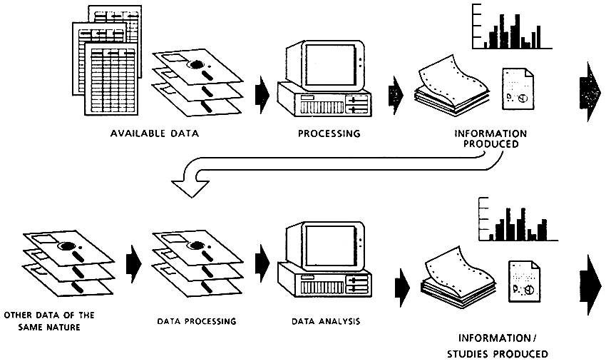
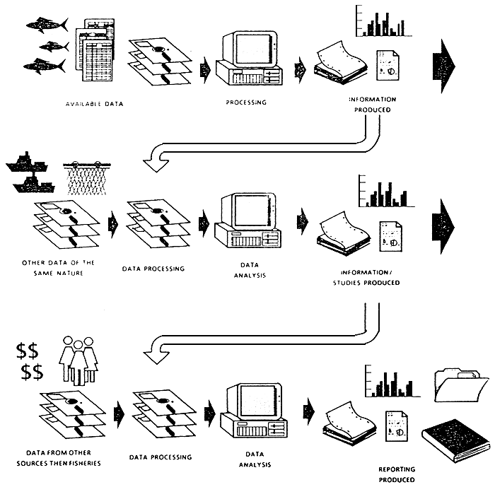
Figures 1 and 2 illustrate how the project operates as a regional body and its direct or sub-project relations with individual countries. The figures also indicate the information and input/output flows among the various components involved. Figure 3 summarizes the geographical distribution of the main project activities which are grouped into courses (regional or national), workshops, research and activities related to the Sistema de Referencia sobre la Investigation en Acuicultura (SIRIAC: «Reference System for Aquaculture Research»).
The programme implemented comprised sub-projects that corresponded to activities of the various national programme. AQUILA selected these sub-programme and provided them with technical and financial support on the basis of needs and achievements that were often common to numerous countries, which broadened the scope of assistance. In other words, the training, research and information activities promoted by the project as a catalyst, channelled the respective national resources and capacities for the benefit of the entire region.
Project intervention took the form of:
Fixed Staff and consultants. The project strategy was to employ a limited number of experts on a regular basis so as to make more funds available for the recruitment of local staff. The main advantage of this startegy was the flexibility it permitted; this approach considerably broadened the range of accessible disciplines and special fields. An additional benefit was the fact that the project was able to tap the technical institutional, social etc., Knowledge of each consultant. Concerning the large number of capable experts found in the region, the system adopted allowed this pool of expertise to be tapped on activated region-wide, including all the countries.
On the administrative level, consultant who were more closely and regularly involved in project operations were contracted through the «when actually employed» system. This enabled the project to employ consultants for a certain number of pre-establish days according to its needs. A small number of these consultants, located in areas and countries of major importance for aquaculture in the region, in practice served as project representatives, and as such, contributed effectively to operations.
Support mechanisms. The regional activities were designed in agreement with the national institutions responsible for their execution and management and with the help of the project staff. Agreement was reached on the objectives, procedure, execution time frame, expected results and resources earmarked. Letters of agreements were signed between the institutions (not necessarily governmental, but necessarily non-profit organizations), and the Project defining their respective obligations. FAO Headquarters delegated the necessary authority to the Project for this purpose. The resources committed to achieve the objectives comprised:
Resources provided by the host institutions (always and exclusively in kind in the form of facilities, equipment, local staff, organization, logistics, administration and management;
Resources provided by the Project in the form of direct support of the Project staff, consultants (almost exclusively form the region), technical information and findings generated during the course of implementation (manuals, research summaries, etc.);
Direct financial support from the Project to cover: the remuneration of auxiliary staff, wage increments for the national institution staff involved (incentives), travel expenses, a contribution towards the acquisition of consumer goods, research and training materials, fuel, a contribution towards equipment maintenance, fellowships, study trips, the preparation and distribution of training and information resources (leaflets, slides, audio-visual material).
As was noted by the Project Evaluation Mission in its two years of operation the Project introduced a network of activities (sub-project) involving numerous national institutions which were therefore able to make better use of (land at times, to reactivate) their resources and capabilities. This exercise was in fact TCDC-oriented in terms of its objectives, though not in terms of its means of operations. During its second phase, the Regional Project will support the gradual development of the present network of activities and its progressive institutionalization at regional level, by supporting the participating countries in:
enhancing the performance of the national structure responsible for aquaculture development and administration, though training, research and information addressed particularly toward sector planning and management;
helping the governments in the identification, formulation and evaluation of technical and economic regional cooperation projects;
introducing mechanisms that will enable the countries to gradually play a greater and more independent role in the management of regional support activities and the procurement of funds;
establishing regional communication and mediation mechanisms which provides countries with a permanent channel for expression of their concerns and needs;
transmitting the information and the experience gained during the execution of the first and second phase of the Project to a regional structure which may follow up the activities.
Figure I AQUILA Operational Diagram. Relations with each country.
Aquila-Pedini
Figure 2 AQUILA Operational Diagram. Relations AQUILA and the countries.
Figure 3 Geographical distribution of main activities.
by Mr. S. COPPOLA and presented by Mr. AMEDEO FREDDI
FAO ROME
SIPAM
(Système d'Information pour la Promotion de l'Aquaculture en Mediterrannée).
INTRODUCTION
This information system design originates from two very important facts, i.e., the strong demand for information from the many scientists involved in planning aquaculture activities at national/regional level and a pilot experience carried out at the formulation stage of a similar information system for Latin America (SIPAL : Sistema de information para la Planificacion de la Acuacultura en America Latina).
Before entering into the conceptual design, and to avoid too high expectations, it must be immediately stressed that the proposed system is not an expert system; in other words it is not a system that generate answers based on the user requirements and its own «accumulated experience».
It is an instrument, a tool, a allow a quick and as vast as possible retrieval of information derived and alimented from several sources. This tool will aggregate the retrieved information into a readable reporting format which has then to be analysed and interpreted.
The following page gives a diagram (Fig. 1) showing the flow of the data and utilisation of the information.
SYSTEM OF INFORMATION FOR THE PROMOTION OF AQUACULTURE IN THE MEDITERRANEAN
SIPAM
The Conceptual Design
The phase of the conceptual design is a very delicate one because precedes the very important one of system analysis where the objectives and justifications have to have already been defined.
The system analysis phase must, in practice, define the feasibility and at what cost, in terms of resources, risks, etc, the project can be implemented.
In this section the components of the proposed information system are presented in order to explain the most important elements related to them.
The information system SIPAM can be defined as being made up of the following components.
An objective
A set (assembly) of human resources
set of automatic and manual instruments for the collection, aggregation, retrieval and processing of data
A set of procedures and techniques to meet the objective.
A predefined data-information model.
1. The Objective
To provide the MEDRAP project, and through it the sub-regional centres and, therefore, the countries adhering to the project, with an instrument and a methodology for rapid and targeted access to data and information of different types and from different sources. This technology will allow all users to establish their own made-to-measure research procedures tailored each time to suit their requirements.
A by-product of this system will be the favouring of exchange of data and information between peripherals (countries) and the centre (the FAO project) putting in motion a process of feedback.
In order to permit each country access to the regional data, the project will design and implement a Regional Information module (see system Description Overview on page…) and put at the disposal of the countries all available information in a readily accessible manner.
2 Human Resources
As described in the following section, the system will be designed using an open architecture, i.e., a modular architecture.
This approach gives the dual advantages of being able to develop the system stepwise with the pre-established possibility of addition and expansion of the elementary modules and to enable more than one programmer to develop different parts of the system independently and simultaneously. In fact, in the development of the overall system the project will make use of regional and subregional analysis/programmers for the FAO and Regional Information Modules, and national analysts/programmers for the National Information Modules.
The basic role of the final user in the design and implementation of the system has to be emphasized. In fact, in its desing this system will not follow the normal logic of «data dissemination» but will be based on the concrete needs of the final users.
For the successful implementation of this work it is imperative that the project provides the services of a full-time system manager. This person, who must have either informatic or aquaculture qualifications, will ensure the correct and timely execution of all the phases of the programme for the development and implementation of this system; The terms of reference of this officer will be included in the final version of this paper.
In addition to the system manager, the project has to foresee the following personnel inputs :
- part-time professional computer programmer assistance, mainly in Tunis and/or in Rome. (for the development of the FAO and Regional Modules)
- national experts on aquaculture planning and computer programming.
- consultants to train regional, sub-regional and national experts in the use and maintenance of the system.
- consultants to prepare reports and technical material.
3. Set of Automatic and Manual Instruments
This system will be designed as an integrated information system. By «integrated system» is meant a homogenous system (harmonious) in which the end user does not perceive that it is built up of different basic elements. It is important to note that in designing this system the end user and his needs, and not the wish to produce one more instrument of data dissemination without a pre-established target, are the main consideration.
For reasons of compatibility with FAO standards, and for other technical and operative reasons, the networking hardware is configured around a platform based on the INTEL 80386 micro-processor family. The elements that need to be integrated to constitute the network through nonrigid connections are of a different nature and effort.
- At the system architecture level national, international and FAO environments used have to be made colloquiable.
- At the structure level different connecting protocols (interfaces) to manage products coming from different environments need to be developed both for the input/output procedure and for the format and structure of the data.
- At the function/service level data format interchange with applicative software (standard commercial software) and connection to different peripherals such as printers, scanners, modems, as well as electronic mail, must be foreseen.
At this level the different working languages to be used in the system have also to be taken into a account. Therefore, the system will be provided with a multi-language date dictionary to allow quick and standardized user interfacing.
The system will be developed, both in the centre and the periphery, on identical hardware in order to optimise the products and ensure the network performance. The configurations described in Appendix I do not necessarily need to be completed at the beginning of the project since they have been designed to be expanded as necessary although they all have to be completed and fully operative by the third phase of the working plan (see work plan and schedule of work).
The system architecture will be designed on a «STAR/STAR» pattern with non-rigid connection in which the centre of the STAR represents the manager/server and the points represent the user. The system will have two levels of STAR connection. For an easier understanding of the above pattern a chart in Figure 3 is shown on the next page. In this particular case the system is developed around a network in which the centre of the first level STAR is represented by the MEDRAP project headquarters where the system manager/sever pilots all the applications at regional level. At the edges of this Star are the four sub-regional centres which, in turn, are the manager/serves (the centre) of the second level STAR in which the edges represent the countries of the same group. The first level Star has one extra edge which represents the link with the FAO Fisheries Department project back-stopping team.
The hardware configurations of the workstation forming the project network are given in Appendix 1.
In Appendix 2 a proforma invoice of the estimated cost of the above configurations from one of the dealers in Rome is given.
This module will be fed with non-confidential restricted data and information of regional interest which each country has put at the disposal of the project.
Alongside the regional module, the project will develop an FAO Information module containing and managing some of the FAO officially-distributed databases.
Each country will develop (with some assistance from project to be defined) a National Information Module containing all the relevant available data/information deriving from the national aquaculture surveys and other sources. This module will have to take into account its possible use in the typical decision-making process that planners use to define objectives and activities.
The overall SIPAM system will work using data and information in a structured and standardized mode to allow exchange and aggregation for textual, analytic and graphic manipulation.
In the following figure (fig. 2), an outline of a typical decision-making process around which the system will br designed, is presented.
SYSTEM OF INFORMATION FOR THE PROMOTION OF AQUACULTURE IN THE MEDITERRANEAN
SIPAM
DECISION MAKING PROCESS
4. A Set of Procedures
The development of the software is strongly influenced by the structural design of this network (STAR/STAR) which has been conceived to allow the integrated system to be developed in a modular way independently from the two levels of implementation. To make full use of the above structure a slightly anomalous approach has been chosen in the development of the sytem. The first level network that links the project headquarters, FAO and the subregional centres applies a so-called 'TOP-DOWN» strategy is typical of vertical initiative in which, without taking too much account of the final characteristics of the user, the application is developed and imposed. For the application of this strategy the initial components (FAO databases with their known specifications and environments) of the system are known before-hand. The FAO information module will be developed and implemented using this strategy and will be distributed by the project headquarters to the sub-regional centres. The subregional centres will manage the flow the data from the single country and themselves and will be responsible for the distribution (installation, training, setting up, etc.) of the FAO module.
The sub-systems that will be developed in the subregional centres (regional information modules) will have the dual task of interacting with the project headquarters and with the country. For the regional module, since it is strongly dependent on the various national contexts, a «BOTTOM-UP» strategy is applied. For this strategy a methodology which permits the identification of many simple problems and their solution independently is applied. This module will therefore be developed by consolidating and expanding the system, both in dimension and application, as new blocks are added from the bottom upwards. This is a strategy where the analyst does not need to know initially all the situations he will be faced with (different national contexts).
One of the most interesting features of this programme of work at the cooperation level is the direct involvement of national personnel in the development and system enhancement of the National Information Modules. On the other hand, this approach (to use national staff for the national module) is considered a basic condition for the success of the programme of work during and after project implementation.
The software to be developed is limited to that for the managment of the FAO and regional information modules and the input/output protocols for uploading/downloading FAO and regional databases, maintenance systems and the interfaces with the various and different natinal systems. Towards the end of the project procedures for tele-maintenance and tele-updating via modem through a «carbon copy» approach, both from Rome and from the project head quarters in Tunis, should be in place. This approach will allow the system manager to temporarily control the remote workstation through the modem and special software.
The analytical function of the system, as well as the word processing, statistical analysis, graphics, project management, etc., will be carried out in one area of the system (sub-system) which will make use of commercial software possibly standard within the FAO family. This sub-system may also contain some programmes and procedures developed by the project to allow standardized and repetitive data processing, report generation, etc. The commercial software may be integrated with some built-in macro instructions to perform certain operations.
For the software development, dBase IV is the selected Data Base Management System not only because it is an internationally accepted de facto standard but also because so many FAO applications, as well as some national applications, have already been developed using dBase. For the supporting software the use of the following soft-ware classified as satandard for FAO is foreseen:
| - | Word processing | word Perfect 5.1 English/French Spanish/Arabic? |
| - | Spreadsheet | LOTUS 123 |
| - | Graphics | Harvard graphics |
| - | Statistical Package | STATGRAPHICS |
| - | Project management tool | MS/project |
| - | High-Level language (only external routines) | BASICA/PASCAL… |
The above packages are acceptable at the moment of writing and, in any case, are only indicative and may be changed and/or added to at any time.
In the following figure (Fig. 4) the functional process of the system is given which follows the same pattern as in Figure 2 Decision-making Process.
SYSTEM OF INFOMATION FOR THE PROMOTION OF AQUACULTURE IN THE MEDITERANEAN
SIPAM
OPERATIONAL PROCESSING CHART
5. Pre-established Data Information Model
The data information flow will be developed within a strategy defined by a working group, composed of national, sub-regional and project experts, which will indicate the information needed. The major concern on the above is the possible inadequacy of some national infrastructure to support the proposed strategy and the obligation to provide additional resources for this work. The data/information flow will grow in a selective manner without duplicating existing work already carried out by other organizations/institutions. The persons on the working group will be in contact with each other to identify and disseminate information of interest from various national, regional and international sources. At this point the project must make a great effort, both in the research of data/information and in reaching agreement with the various institutions to obtain authorization to receive and utilize the data/information that they need.
In fact, as far as the relationship with FAO is concerned, this subject is regulated by D-G Bulletin No. 90/22, and is object of discussion by a working group set up by the Director-General to give guidelines on this matter. The project MEDRAP will be responsible for obtaining the data/information Module (FAO sources).
Regarding the national data/information to be integrated in the sub-regional and regional systems (Regional Information Modules), the national coordinators will be responsible for obtaining such authorization. However, the project should prepare a standard draft letter of agreement between the project itself and the national institution concerned to be used as a basis.
It is of paramount important for the present and future life of this system that all data entering the SIPAM network be appropriately authorized.
The data/information model used in this system will be of a complex type. In this integrated information system the model is of third level where:
first level = basic model
second level = sectorial model
third level = complex model
In the basic model the data collected through a system is processed and published according to given methodology, standards and intervals (output). In an organizational structure it is the task of a basic data unit to accomplish this.
In the sectorial model, some of the information produced by the first model becomes data (input to be processed and analysed together with data and information coming from other sources within the same field. In an organizational structure it is the task of specialized units to accomplish this.
In the complex model, some of the information produced by the first and second models becomes data (input) to be processed and analysed together with data and information coming from sources of a different nature. In an organizational structure it is the task of the above two types of unit plus an information unit to accomplish this.
In the following figure (Fig. 5) the complex data information model is shown.
DATA INFORMATION MODEL
BASIC MODEL
DATA INFORMATION MODEL
SECTORIAL MODEL
DATA INFORMATION MODEL
COMPLEX MODEL
Work plan and Schedule of Work
The Project MEDRAP, through its Headquarters in Tunis and the four sub-regional centres and some selected countries within the Project area, will launch a programme of work with the aim of establishing an intergrated information system to assist national planners in the field of aquaculture. This target will be accomplished by:
- developing the methodology and providing a tool to collect and process in a systematic way information useful for aquaculture planning at the national level (National Information Module). In addition to their own data, the countries will have direct access (from the same workstation) to regional data.
- designing and implementing a Regional Module to put regional and international information at the disposal of the countries in a readable and comparable format. The Regional Information System will be alimented with non-reserved national data of regional interest which each country has put at the disposal of the Project.
- designing and implementing an FAO Information Module which will incorporate all the available FAO databases of interest to this programme of work.
- designing and implementing a network linking national, sub-regional centres through automatic data transmission.
- assisting the sub-regional centres and the selected countries in the use and maintenance of the system.
- extending whenever and if possible the network to other countries.
Schedule:
| Phase I | |
| April 91 | Discussion and approval of the above design ordering of the above design ordering of the equipment |
| Design and implementation of the pilot FAO Information Module | |
| Identification of some countries to be included in the pilot Regional Information System | |
| Identification of the planning process in the above countries | |
| Analysis of the planning process and the available national data in the selected countries | |
| Delivery and installation of the workstations | |
| Phase II | |
| Assistance from the Project to national coordinators of the selected countries to develop the National Information Module | |
| Development of interfacing protocols to integrate national systems into the regional information module. | |
| Design and implementation of the Regional Information Module | |
| Testing, evaluation and validation of the three Modules | |
| Integration of the three Modules into the system | |
| Delivery to and installation of the full configuration in the selected countries (training, etc. included) | |
| Phase III | |
| Evaluation and improvement of the delivered systems | |
| Expansion of the system to other countries | |
| Completing the network by setting up automatized data communications | |
| Analysis and evaluation of the whole programme of work | |
APPENDIX 1
HARDWARE CONFIGURATION FOR THE WORKSTATIONS
FORMING THE PROJECT'S NETWORK
A. Server/Manager Workstation, 1st level (Project HQ)
Personal Computer IBM or 100% compatible with the following characteristics:
- Desk top type
- CPU 80386 at 25 MHZ 2MB RAM expandable
- colour monitor 14» VGA card
- 1 M. disk drive unit 1.44 Mbytes 3.5»
- 1 F. disk unit 1.2 Mbytes 5.25»
- 1 H. disk drive 100 Mbytes - Acc. time <30 m.sec
- International advanced Keyboard 102 Keys
- 2 Parallel Ports
- 1 Serial port RS 232 C
- Bus mouse microsoft or microsoft compatible
- 1 back-up tape unit
- 1 Modem Haynes compatible 960/1200/2400 band rates
- 1 Advanced Arabic Keyboard
- 1 Advanced French Keyboard
- 1 Matrix dot printer wide carriage (136 chrs) with NLQ capability/24 pins/260 chrs/sec IBM/EPSON compatible parallel interface
- 1 Laser printer HP laserjet III compatible parallel interface
- 1 Scanner HP SCANJET compatible
It is strongly advisable to parallel the above microcomputer with another one similar in characteristics and lower in performance (because of cost) to be used for system development, as server back-up unit, and for other duties to be assigned.
Personal Computer IBM or 100% compatible with the following characteristic :
- Portable type
- CPU 80286 at 12 MHZ 640 Kbytes RAM Expandable
- 1 Back lit L.C : monitor VGA compatible
- 1 M. drive unit 1.44 Mbytes 3.5»
- 1 H. disk 20 Mbytes Acc.time<30 m.sec
- 1 Parallel port
- 1 serial port
- Travel accessories (bag/batteries, etc.)
- 1 Diconix or cannon portable printer with travel accessories
- 1 Modem
B. Server/Manager, 2nd level workstations (sub-regional centres)
Personal Computer IBM or 100% compatible with the following characteristics :
- Desk top type
- CPU 80386 SX at 16 MHZ 2 Mbytes RAM expandable
- Colour monitor 14» VGA card
- 1 M. disk drive unite 1.44 Mbytes 3.5»
- 1 H. disk drive 60 Mbytes - Acc.time <30m.sec
- 1 International advanced keyboard
- 1 Parallel port
- 1 Serial port RS 232C
- 1 Bus mouse microsoft or microsoft compatible
- 1 Modem Haynes compatible 960/1200/2400 band rates
- 1 Matrix dot printer wide carriage (136 chrs) with NLQ capability*24 pins*260 chrs/sec*IBM/EPSON compatible* parallel interface
C. FAO HQ Rome (for system design, backstopping and feedback)
Personal Computer IBM or 100% compatible with the following characteristics :
- Portable type
- CPU 80286 at 12MHZ 640 Kbyes RAM Expandable
- 1 Back lit L.C : monitor VGA compatible
- 1 M. disk drive unit 1.44 Mbytes 3.5»
- 1 H. disk drive 20 Mbytes Acc. time <30 m.sec
- 1 Parallel port
- 1 Serial port
- Travel accessories (bag/batteries, etc;)
- 1 Diconix or canon portable printer with travel accessories
- 1 Modem
One workstation in the backstopping Service to be shared for this work. This system is the property of FAO/FI Dept.
Note. All workstations will be provided with identical software covering :
- DOS Operative System
- Word Processing
- Spreadsheet
- Data Base Management System
- High level language
- Data communication software
- Tools
- Specific applications
![]()
![]()