![]()
![]()
![]()
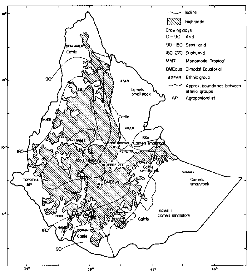
The lowlands of Ethiopia form a wide apron surrounding the highland massif. Part of the lowlands is the Great Rift Valley, which divides the west-central highlands from the north-eastern, eastern and southern lowlands. A map depicting highlands and lowlands and climate regimes is provided in Figure 1.1. The Great Rift Valley is demarcated in this map by territories of the southern Afar, Issa and Kereyou to the north-east and Bodi to the south-west. The climate regimes are defined in terms of interactions between temperature and precipitation that largely define plant growing periods and variation in human exploitation patterns. This review closely follows Westphal (1975: pp 18-27), Workineh Degefu (1987) and EMA (1988).
The main factor influencing air temperature in Ethiopia is elevation. As elevation increases air temperature falls. The lowlands below 1500-m elevation are thus the warmest parts of the country, with annual mean temperatures ranging from 20 to 25°C. Because the highland massif occupies such a large and central position in Ethiopia, gradients in altitude and air temperature can be visualised as a series of concentric belts radiating outwards from the geometric midpoint of the highlands. The warmest lowlands occur to the "outside" of the 25°C isotherm (EMA, 1988). In the north this isotherm travels in a south-easterly direction parallel to, and about 100 km inland from the Red Sea. It then descends into the Danakil Plain, cuts briefly north, and proceeds east parallel to the Gulf of Aden. Next it sweeps south, bisecting the Ogaden region, curls through the south-east portions of the Bale and Borana Administrative Regions, approximately coincident with 1000-m elevation. The 25°C isotherm occurs much closer to the highland escarpment in the west than in the east (EMA, 1988). In contrast, the 20°C isotherm is coincident with 1500-m elevation all along the perimeter of the highland escarpment.
Superimposed over this crude temperature pattern is a more diverse assortment of rainfall regimes. Westphal (1975: pp 22-23) lists six for the country overall. Detailed rainfall maps can be found in Workineh Degefu (1987) and EMA (1988). For the lowlands the basic dichotomy involves unimodal and bimodal systems. Four dominant systems are briefly described below.
In terms of extent of land affected, the most important unimodal system is to the extreme north and north-east (Afar territory in Figure 1.1), where the maximum (70 to 80%) of the annual precipitation of 200 to 600 mm occurs in December through February. This rainfall is partly cyclonic and partly orthographic in origin. Rainfall increases to the south towards the highland escarpment.
Another unimodal system, referred to as the "Sudan" type, has most of the annual delivery of 800 to 1200 mm occurring during June through August. This occurs in the lowlands along the border with Sudan (Nuer and Topotha territories in Figure 1.1). This system also varies in terms of a latitudinal rainfall gradient with heavier and more reliable rainfall in the south.
The most prominent bimodal system occurs in the Ogaden and Borana regions (Figure 1.1) and dominates much of the Horn of Africa. The total annual rainfall under this regime ranges from 250 (Ogaden) to 700 mm (northern Borana Plateau), with 50 to 60% occurring in March through May and 25 to 35% in September through November. The rainy periods coincide with equinoxes when low pressure over southern Sudan attracts moist winds from the Indian Ocean. A cool, foggy period, a result of the gradual warming of air as it passes inland, may occur from June through August. Rainfall is lowest in the central Ogaden and increases towards the west (Bale), south and south-east (Borana Plateau).
Another bimodal regime occurs in the extreme south-west (Hamer and Bodi territories in Figure 1.1). This has lower and more variable annual rainfall (300-600 mm) than the Borana Plateau. Most (55-65%) of the rainfall occurs from March to May and from December to February. This system is influenced by the climate of the Lake Turkana basin in Kenya.
The regional variation in temperature and rainfall in the lowlands provides a basis for understanding climatic variability. This, in turn, yields important differences in vegetation and primary production that influence human ecology and agricultural development potential. For example, very arid climates tend to occur under unimodal rainfall and warmer temperatures, while the semi-arid climates occur under bimodal rainfall and cooler temperatures closer to the highland massif. Westphal (1975: pp 25-27) describes in detail eight climate types for all of Ethiopia. Here a simpler categorisation (Pratt Gwynne, 1977; Jahnke, 1982) is used to partition the lowlands into three agro-ecological zones.
The arid zone has up to 90 growing days per year. It includes the lowest areas such as Dalol in Afar territory near Djibouti, which has the lowest elevation in the country at 100 m below sea level. The arid zone makes up nearly 64% of the lowlands, including territories of the Beni Amer, Afar and Issa to the north and north-east and the Somali in the eastern half of the Ogaden. The arid zone is composed of the warmest regions (including the 25°C isotherm) in combination with either lower annual rainfall (mostly unimodal, but some bimodal systems up to 400 mm/year) and often thin, weakly developed Xerosols and poorly differentiated sandy substrates or volcanics that contribute edaphic sources of moisture stress. Range plant communities have low production potential. Total dry-matter (DM) production is commonly <1 t DM/ha/year. On undegraded sites the carrying capacity can range from 4 to 16 TLU/km2, given the wide variability in annual rainfall (Pratt and Gwynne, 1977: p 112) (The validity of the carrying-capacity concept is discussed further in Chapter 8: Synthesis and conclusions). Vegetation types include dwarf shrub grassland, shrub grassland and dry thorn bushland. Plant species include herbaceous perennials and annuals (Aristida, Eragrostis, Cenchrus and Chrysopogon spp) and small to medium-sized woody plants (Indigofera, Sericocomopsis, Acacia and Commiphora spp). Livestock composition is diverse but tends to emphasise browsing species (camels and goats) that forage from woody vegetation. Human lifestyles are nomadic, involving frequent movements of households as well as animals. Social systems tend to be decentralised in terms of traditional leadership (Donaldson, 1982). Cultivation is very risky and often confined to early maturing drought-tolerant grain crops (e.g. sorghum or millet) planted in depressions or flood plains.
The semi-arid zone has from 90 to 180 growing days per year. This zone clings to the periphery of the highland massif below 1500 m elevation, except in the west where it occurs below 1000 m. It also includes higher elevations in the Rift Valley (near the Kereyou territory in Figure 1.1), the Nuer region to the north-west, the Gujji and Borana territories to the south and the western portion of the Ogaden. The semi-arid zone makes up about 21 % of the lowlands. Annual temperatures tend to be cooler than in the arid zone (more representative of the 20°C isotherm) and rainfall (400 to 700 mm/year) is bimodal except in the Nuer region, which is under a unimodal regime. Soils include Xerosols and volcanics. Range plant communities have much higher potential productivity than those of the arid zone, with total DM production of 1 to 3 t DM/ha/year (Cossins and Upton, 1988a). Carrying capacities are higher and less variable than in the arid zone. Means range from 14 to 28 TLU/km2, with variation ranging from 11 to 33 TLU/km2 overall (Pratt and Gwynne, 1977: p 112). Plant communities commonly consist of perennial savannahs and dry woodlands with grasses such as Themeda, Cenchrus, Chloris and Chrysopogon spp. Overstories are typically dominated by Acacia and Commiphora spp, with Brachystegia and Combretum spp when conditions are more moist. Under higher rainfall the tendency is for woody plants to increase at the expense of grasses, but this can often be slowed by regular use of fire. Management can thus have an important role in shifting vegetation composition between conditions of woody and herbaceous dominance. The greater stability and productivity of the grass layer relative to the arid zone promotes more grazing cattle and sheep, although browsing goats and camels can thrive in wooded or bushed areas. People here tend to be semi-nomadic, with households sedentary in most years and livestock being mobile if necessary. Compared with the arid zone, livestock diseases appear to be a more serious production problem in general (Sileshi Zewdie, SORDU veterinarian, personal communication). Agropastoralism may also emerge on favourable water-collecting land- scapes and maize is an important food staple.
The subhumid zone has from 180 to 270 growing days per year. This zone occurs near 1500-m elevation (particularly to the west) and has a longer growing season than the drier zones due to higher annual rainfall (800 to 1300 mm) and lower temperatures. Subhumid regions also extend into pockets of the highland massif and in total may comprise 15% of the lowlands. Native vegetation types commonly consist of moist perennial savannahs and woodlands. Taller grasses such as Hyparrhenia spp are more frequent than in drier zones, with an overstory dominated by Brachystegia, Terminalia and Combretum spp with some Acacia spp. Cultivation of cereals (especially maize) is important and tends to be limited more by soil fertility than by moisture (Jahnke, 1982). Sedentary, mixed crop-livestock operations are more the norm. Land availability is usually not a major limiting factor (Jahnke, 1982). Biomass yield of forage is on the order of 6 t DM/ha/year and livestock nutrition tends to be limited by forage quality rather than forage quantity. Carrying capacities average around 66 TLU/km2 with low annual variation because of the greater predictability of rainfall. Livestock, however, tend to be relatively less important in the rural economy than in the drier zones, largely because of diseases such as trypanosomiasis. Common livestock are cattle, sheep and goats. Camels are not typically kept where annual rainfall is over 900 mm (Wilson, 1984).
For in-depth reviews of climate, vegetation and land-use practices in the lowlands of Ethiopia and East Africa the reader is referred to Lind and Morrison (1974), Westphal (1975), Pratt and Gwynne (1977), Jahnke (1982), Workineh Degefu (1987) and EMA (1988).
![]()
![]()
![]()