![]()
![]()
![]()
This section highlights some of the technical methods used for collection of original data for soils, climate, plant ecology, forage chemical analysis and social surveys reported in this chapter. Methods used to collect secondary information reviewed here can be found in the cited literature.
Eight pits were dug on soils representative of dominant upland and lowland substrates largely in the eastern half of the study area. Pits were analysed to a 2-m depth in 1986 to 1987. Standard methods for the physical and chemical analyses of soils can be found in Kamara and Haque (1987: pp 12-14; 1988: pp 7, 14-15). These include use of Munsell charts for soil colour, analysis of soil pH using a 1:1 water to soil ratio, organic carbon by the Walkley-Black method, nitrogen by micro-kjeldahl, available phosphorus by the Bray II method, bulk density by the core method and soil moisture by pressure plate and pressure membrane techniques.
Air temperature and rainfall data were collected by SORDU staff on a daily basis from a network of seven and 10 monitoring stations, respectively, set up during 1979 as part of the national meteorological network with assistance from ILCA. Stations were set up in towns and field sites throughout the central plateau where data collectors could reside and equipment could be supervised. Because towns tend to be in wetter environments at higher elevations, the data are probably biased on the high side for rainfall and on the low side for temperature for the region as a whole. A map of the monitoring sites and a preliminary synthesis of data collected from 1980 to 1982 for SORDU (as well as JIRDU and NERDU) can be found in Billé (1983). The location of some of the major towns having key climate stations is shown in Figure 2.2. Linear regressions were used to relate annual mean rainfall or temperatures with elevation. Climate diagrams (Michel Corra, ILCA, unpublished data) were based on analytical assumptions of Walter et al (1975) in which plant growing periods were assumed to be those times when monthly rainfall (mm) was twice the ambient temperature (°C) - these being times when soil moisture storage was most likely. Lengths of growing periods (LGPs) based on climate data were estimated in Cossins and Upton (1988a: pp 118-119) using a water-balance model of FAO (1978). Monthly rainfall data for five sites were used to calculate LGPs based on the assumption that plant growth occurs only when monthly rainfall exceeds a threshold of half the potential evapotranspiration. Length of growing period was also assumed to be normally distributed with a coefficient of variation of 30%. Dry-matter (DM) production of forage was assumed to be directly related to LGP on the basis of 17 kg DM/ha/day of growth (Cossins and Upton, 1988a).
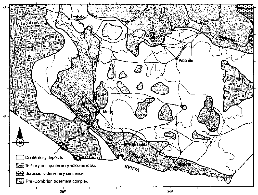
Figure 2.2. Primary geological features of the central Borana Plateau.
Source: EWWCA (1987).
How environmental variables influenced distributions of native plant species was analysed by Corra (1986) using 134 one-hectare sites throughout the study area. Field procedures followed Goudron et al (1968): Each site was characterised in terms of: (1) dominant plant species (presence/absence); (2) vegetative physiognomy (i.e. bushland, grassland, woodland etc) scored into one of five categories as in Pratt and Gwynne (1977); (3) colour of the top soil into one of four groups (Munsell Color, 1975); (4) soil reactivity (positive or negative) to 4.0-M hydrochloric acid to assess acidity; (5) slope scored into one of four categories; (6) elevation measured with an altimeter and scored into one of six classes; (7) per cent tree crown cover, shrub crown cover, herbaceous (grass and forb) cover, bare soil and exposed bedrock; and (6) presence or absence of gulley or sheet erosion. These data were analysed in two ways: (1) frequency distributions of plant species across all categories of each environmental variable for tabular display; and (2) an integrative method using detrended, canonical correspondence analysis (CANOCO), a form of ordination (ter Braak 1988). This was intended to quantify interactions among environmental variables in terms of their effects on plant species distribution. The ordination exercise was depicted as a graph which integrates all variables in explaining their effects on the occurrence of each plant species. Plant species occur as points on the graph and the environmental variables are shown as vector arrows or points, depending on whether the variables are continuous or discrete. Plant species nomenclature in this volume follows Pratt and Gwynne (1977) and AGROTEC/CRG/SEDES Associates (1974d).
Chemical analyses of forage materials followed standard methods for organic matter nitrogen, fibre and in vitro digestibility (Goering and Van Soest, 1970; AOAC, 1980; Van Soest and Robertson, 1980). Tannins in browse forage are reported from Woodward (1988) and her analytical methods followed Reed et al (1985) and Reed (1986).
Information on social aspects of resource management and water production from wells was obtained through survey and/or systematic observation (Cossins, 1983c; Donaldson, 1983; Cossins and Upton, 1987). Methodological details will be reported in the discussion as warranted.
![]()
![]()
![]()