![]()
![]()
![]()
3.2.1 Ecology and land-use map
3.2.2 Long-term vegetation change
3.2.3 Short-term vegetation change
3.2.4 Population ecology of woody species
3.2.5 Use of native vegetation
Surveys of twelve 20 × 20-km regional blocks (see below), Landsat imagery and other reconnaissance data collected during 1982 to 1985 were used to prepare an ecological map at a scale of 1:500000 for a 26600-km2 region (Assefa Eshete et al, 1986; for a review of the study area see Section 2.2: Study area selection and system delineation). This approach delineated six agro-ecological zones, with three to six ecological units/zone and an average of four subunits/ecological unit. Key issues relevant to resource use, range management and ecological sustainability were noted at unit and subunit levels, with trends over time identified using previous maps by AGROTEC/CRG/SEDES Associates (1974d, 1974i, 19741), aerial photographs and satellite imagery (Assefa Eshete et al, 1986: pp 3, 21). The new map was justified because previous maps of the region had insufficient detail for land-use planning (Assefa Eshete et al, 1986: p 1).
Research reported here was primarily conducted during 1982 to 1986 Billé nd; 1982,1985; Billé and Assefa Eshete, 1983a; 1983b; 1984; Billé et al, 1983; Billé and Corra, nd; 1986; Assefa Eshete et al, 1986). One objective of this work was to formulate hypotheses that linked livestock pressure to compositional dynamics in plant communities and conduct preliminary tests. In total this work focused on twelve 20 × 20-km blocks selected based on ecological and development criteria Billé 1982). Two blocks were located in the arid zone, eight in the lower semi-arid zone, and two in the upper semi-arid zone. The arid zone (19% of the study area) occurs at <1200 metres above sea level with an annual rainfall <450 mm, while the upper semiarid zone (22% of the study area) occurs between 1500 to 1700 with an annual rainfall of 600 to 700 mm. The lower semi-arid zone (40% of the study area) occurs between the arid and upper semi-arid zones and is intermediate in rainfall. Observations from other work on range trend in the subhumid zone will also be referred to in this chapter, but this work did not involve analysis of blocks (Assefa Eshete et al, 1986; Pratt, 1987 a,b). The subhumid zone (7% of the study area) typically occurs over 1600 m and has 700 to 1200 mm of annual rainfall. The arid and lower semi-arid zones occur on a diverse assortment of granitic and volcanic soils and their mixtures, and in many instances shallow soils significantly contribute to an edaphic source of aridity. Basement-complex soils tend to dominate higher elevations (see Section 2.4.1.1: Geology).
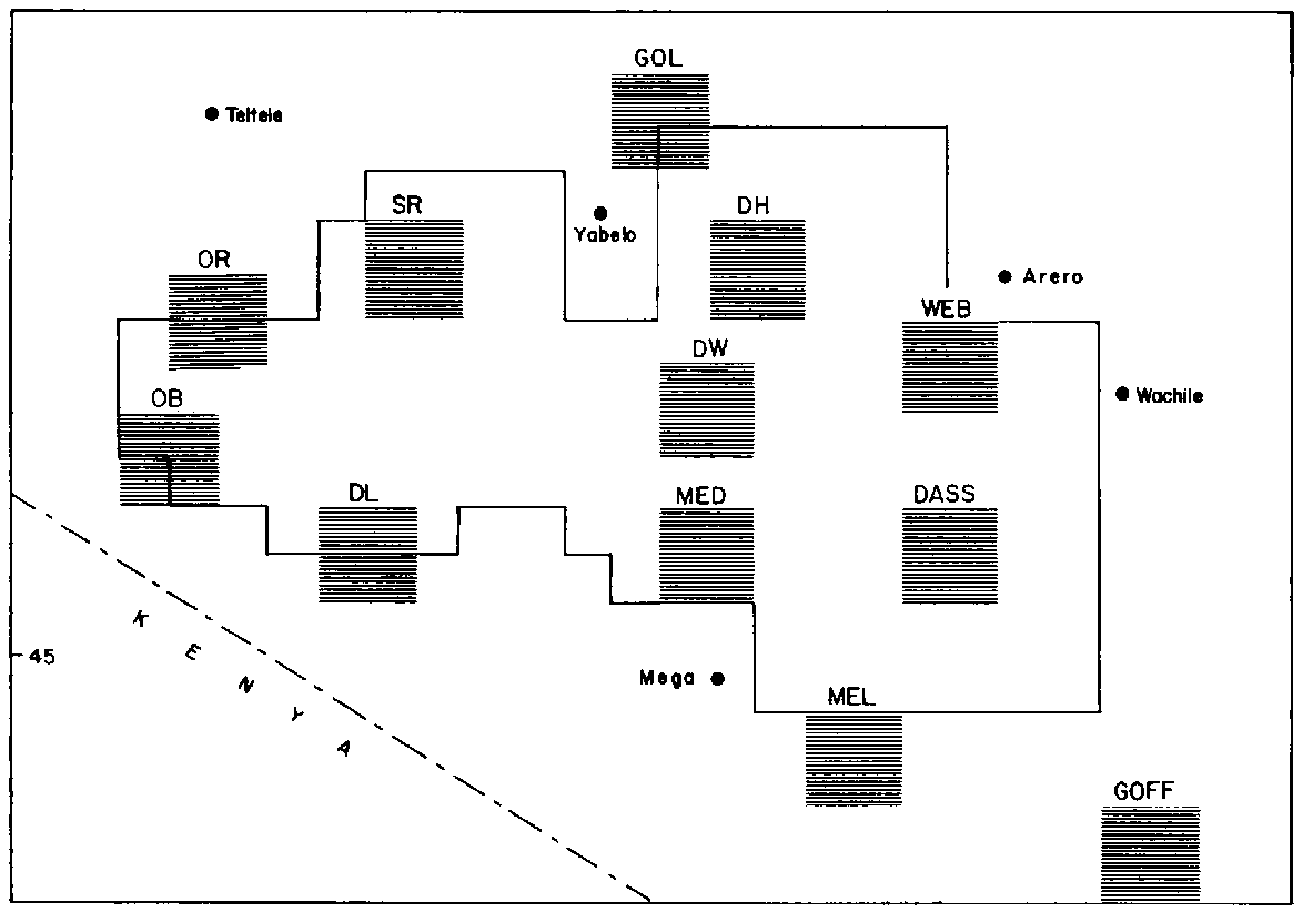
Analysis of the 20 × 20-km blocks was designed to compare environmental trends by contrasting frequency distributions of grazing intensity, degree of erosion, grass and woody cover and density and age structures of woody populations from extensive rapid sampling. Blocks were compared that varied in historical intensity of pastoral use and thus would serve as natural treatments (Figure 3.1). These analyses compared: (1) four blocks in the lower semi-arid zone (in the Dass, Goff, Melbana and Web madda) that represented various stages of pastoral impact in the deep-wells area Billé et al, 1983); (2) two blocks in the lower and upper semi-arid zones (at Medecho and Did Hara madda, respectively) that varied in recent duration of pastoral use due to immigration in response to water development at Did Hara or emigration from Medecho Billé and Assefa Eshete, 1983b); and (3) data from one block at Gololcha (1600 to 1900 m elevation) at the boundary between upper semi-arid and subhumid zones where development of a large, permanent pond recently allowed a high degree of pastoral sedentarisation Billé and Assefa Eshete, 1984) and a high density of resident livestock. A cattle density of 52 head/km2 was recorded in Gololcha in 1982, roughly twice the density for the rest of the study area overall (Milligan, 1983: p 37). The annual rainfall at Gololcha is about 700 mm (see Section 2.4.1.4: Climate, primary production and carrying capacity).
The four semi-arid blocks studied by Billé et al (1983) at Dass, Goff, Melbana and Web represented regions that had been used by pastoralists for centuries. All four regions were assessed to be generally similar in terms of density of well groups, soils, landscape, altitude and potential vegetative physiognomy. Aerial surveys during June 1982 indicated that the average stocking rate for the four regions was 24.6 head/km2 (Milligan, 1983: p 37). Recent grazing history varied as Goff, located to the east, was abandoned by pastoralists for a few years during the late 1970s due to security problems, but was reoccupied by 1980. In contrast, the other regions have been continuously occupied during the past few decades.
The second study, conducted at Medecho and Did Hara, involved regions regarded as generally similar in terms of cattle density (average of 24 head/km2; Milligan (1983: p 37), annual rainfall (550 to 650 mm), soil parent materials (mixtures of volcanics and granitic materials) and density of water points. They differed principally, however, in recent intensity of use. Over the previous six years (1976 to 1982) Did Hara had endured a doubling of human population in response to the construction of permanent ponds that opened the area to sedentary encampments (some of which began to resemble large permanent villages). Medecho, in contrast, had been occupied for centuries but was in a state of population decline by the early 1980s (some of its residents may have moved 60 km north to Did Hara). Evidence for the different population dynamics of the two regions was inferred (in part) from variation in the proportions of occupied vs unoccupied encampment sites. There will always be some unoccupied sites because encampments move every five to eight years (Cossins and Upton, 1987). However, of 139 sites in Did Hara, 39% were occupied in 1982-83, while at Medecho only 14% of 184 sites were occupied Billé and Assefa Eshete, 1983b: pp 30-31). Year-round access to permanent ponds in Did Hara probably also encouraged less mobile grazing strategies compared to Medecho. Cattle in Medecho radiate out in wet seasons to access forage near ephemeral ponds and return to graze closer to the central wells in dry seasons.
The 20 × 20-km blocks were initially mapped using aerial photographs from 1965 and 1967 at a scale of 1:50000 to delineate landscape facets with reference to previous surveys by AGROTEC/CRG/SEDES Associates (1974d; 1974i; 1974j). Ecological units of similar vegetation and soil features were identified using two-colour composite prints from Landsat (ERTS E 2368 070 20501 in bands 5 and 7 of 25 January 1976) and transcribed to a topographic map at a scale of 1:250000. Ecological units were mapped and described further from ground-truthing during 1982 to 1983. The number of ecological units/block ranged from four to eight. Detailed maps of each block may be found in Billé and Assefa Eshete (1983a; 1983b; 1984) and Billé et al (1983).
Quantification of environmental variables in each block was based on an ocular survey method developed by Billé (nd) which employed up to 50 sample points per block, located along a driving route at 1 km intervals. The route was designed to maximise observation of dominant ecological units in each block. At each sampling point a 1-ha site was described in terms of: (1) per cent of canopy cover for herbaceous and woody layers, estimated into one of five classes; (2) density of woody plants; and (3) scores of 1 to 5 for topographic class, slope, degree of erosion, and grazing pressure Billé 1982). Random sampling of woody plants was used to obtain age structures of populations. Age class was estimated by measuring circumference of single or central boles and placing them into one of seven categories from 1 to 70 cm in circumference. Plants with a bole circumference of 20 cm were considered to be at least 70 years old Billé and Assefa Eshete, 1983a: p 7).
Other extensive surveys which documented soil erosion, bush encroachment and incidence of cultivation throughout the study area were conducted using systematic aerial reconnaissance. These methods are described elsewhere (see Section 4.2.6: Grain cultivation).
3.2.3.1 Effects of excluding livestock
3.2.3.2 Interactions among woody and herbaceous plants
The Boran have recently started a system of kalo or dry-season grazing reserves for calves (Menwyelet Atsedu, 1990; see Section 7.3.1.2: Grazing management). Over 90% of surveyed encampments (N = 127) now have these reserves (Coppock and Mulugeta Mamo, 1985; Menwyelet Atsedu, 1990), averaging about seven years old and 12 ha in size and protected against open grazing by bush fencing and/or decree. They are typically used by women to collect grass for handfeeding young calves, although some grazing may occur in the dry season. Kalo usually occur on sites with deeper soils where grass production is higher and some green biomass persists into the dry season. The presence of similar but unprotected sites adjacent to these reserves gave an opportunity to measure effects of continuous versus restricted use on soil and vegetation characteristics, showing greater cover, diversity and productivity of vegetation and an improved soil nutrient status for Kalo compared to unprotected sites (Smoliak et al, 1972; Brand and Goetz, 1986).
Eight pairs of sites (six on red and two on grey soil) were analysed in terms of: (1) per cent cover composition and species diversity of herbaceous and woody plants; (2) net primary production (NPP) of herbaceous functional groups (i.e. grasses, fortes, legumes and total); and (3) nutrient characteristics of top soil. Percentage basal cover was determined for herbaceous plants on 1-ha sites using sixty 0.1-m2 quadrats (Daubenmire, 1959) placed in a stratified-random fashion. Four 15 × 150-m belt transects were used in parallel for cover of woody plants on 5-ha sites with total counts and crown-diameter measurements taken for intercepted plants. Species diversity was quantified using the Shannon-Wiener index (Shannon, 1948). Net primary production of herbaceous components (grasses, fortes, legumes and total) was estimated over the long wet season (April to May) of 1989 by subtracting the terminal standing crop of the previous dry season (March) from the peak standing crop near the end of the wet season. Biomass of each 1-ha site was estimated from clipping forty 0.25-m2 quadrats placed in a stratified-random fashion. Sites were protected from grazing in order to allow standing crop data to be used in this fashion. Soil texture and concentrations of organic matter, nitrogen, phosphorus, potassium and exchangeable cations were analysed using standard techniques (Kamara and Haque, 1987: pp 12-14), and compared among paired sites using four samples each. Each sample was a composite of eight cores, 30 cm in depth, collected on a transect that traversed several hectares/site. Statistical analyses for all variables employed a one-way analysis of variance (ANOVA) blocked by soil type. Details are available in Menwyelet Atsedu (1990).
Effects of woody plants on productivity and composition of herbaceous vegetation is significant for interpretating impacts due to bush encroachment. As part of the analysis of Sarite ranch (Figure 3.1), Solomon Kebede (1989) studied effects of Acacia horrida and A. seyal on the understorey during the long rainy season of 1987. He performed an experiment in which trees were paired and one was cut down with the stump being treated with arboricide to kill the root. Sites were bush fenced to prevent grazing so that herbaceous NPP could be measured in controlled and treated situations up to a radius of 4 m from tree trunks. Sixteen 0.25-m2 quadrats were clipped to ground level in a stratified design and biomass was separated into various components prior to drying. Production was estimated by subtracting standing crop at the end of the dry season from that at the end of the following long rainy season, sampled 120 days apart. Overall, the analysis was based on 144 trees/species distributed among four size classes and three sites. Data were analysed using a four-way ANOVA with species and site as main factors and size class and distance from trunk as sub-factors. Roots were excavated to assess tree-root morphology (Solomon Kebede, 1989: pp 119-131).
Billé and Corra (nd) investigated effects of five Acacia and Balanites species on understorey cover during the long rainy season of 1986 at the Dembel Wachu ranch (Figure 3.1). One large tree (with a trunk diameter of 15 to 35 cm) was randomly selected on a level site for each species. Herbaceous cover around each tree was measured using about 500 reflectance readings from a portable radiometer held 1 m above ground level. Each reading measured green reflectance from 4×4-m plots located within a series of concentric circles up to a maximum of 8 m from each tree. These readings, referred to as normalised difference vegetation index (or NDVI), were highly correlated with standing biomass (Billé and Corra, nd) showing that the trees had no effect on understorey cover (Boutton and Tieszen, 1983; Kennedy, 1989).
Research was directed towards the population ecology of Acacia brevispica and A. drepanolobium, which are increasing in the study area on upland soils and Vertisols, respectively (Tamene Yigezu, 1990). A laboratory study examined effects of various treatments on germination rates of seeds to determine germination strategy. Seeds with a hard coat have a conservative strategy because they can stay in the soil for years before germination, while those with a soft coat can germinate shortly after deposition (Harper, 1977: p 99). Treatments included a background of constant (28°C) or variable (15/30°C) air temperature, with or without scarification of seed coats using sand paper or by immersion of seeds in hot water (98°C for 7 min). The sandpaper treatment was meant to achieve maximum germination while the hot water was intended to reveal to what extent germination was controlled by a waxy layer. Seeds with waxy layers may be more able to germinate after heat treatment caused by natural phenomena such as fire (J. Hanson, ILCA, personal communication). Data were collected on per cent of seed germinated over a 21-day period for four replications/species/treatment with 100 seeds/replicate. Data were analysed using a factorial ANOVA to determine effects of species, temperature and scarification method. In addition, there was a one-month trial conducted under nursery conditions where effects of species, soil type (red and black), planting depth (0, 1 or 3 cm below the soil surface) and watering frequency (initially only or weekly) on germination rate were studied. There were eight replicates/treatment. One replicate consisted of 25 seeds in a plastic pot. Data were analysed using an ANOVA for a randomised-block design.
Phenology was characterised in the field at 11 monthly intervals for plants of both species along two replicated transects at three sites. Each replicate consisted of 35 plants distributed among several height classes. Data were analysed using an ANOVA with phenology scores as dependent variables and species, site, height class and month as independent variables. Seed production was estimated from data on numbers of dry dehiscent fruits and seeds/fruit for 35 individuals and 100 fruits/species. An ANOVA on fruit yield/tree utilised species, sites and height class as independent variables. Seed pools were quantified using fifty 30-cm soil cores/site at different seasons. Root morphologies were characterised using excavations. Seedling recruitment in the current year was gauged using random plots associated with line transects. Details are available in Tamene Yigezu (1990: pp 93, 108-114, 147-150, 198-200).
Maps of the extent of A. drepanolobium populations in the north-central region of the Borana Plateau were compiled by Tamene Yigezu (TLDP/ILCA postgraduate researcher, unpublished data) based on aerial surveys conducted in 1988.
3.2.5.1 Livestock food habits
3.2.5.2 Household use of plants and pastoral perceptions of range trend
Working in the Beke Pond region in the upper semi-arid zone near Gololcha, Woodward (1988) studied feeding ecology of livestock in relation to a local community of trees and shrubs. One objective of the work was to evaluate local browses in terms of development potential by assessing their nutritive value, phenology, abundance, relative use by livestock and population trend. Seasonal feeding habits of cattle, camels, sheep and goats were quantified from observations of eight adults of each species for five hours/animal/day in two wet and two dry seasons during 1985-86. This gave a total of 128 animals observed for 640 hours. Forage consumption was recorded as was the time an animal spent eating each species, bite rates per forage species and bite sizes per forage species. The relative availability of each woody species to different livestock species was estimated by measurements of density, phenology, leaf production and leaf accessibility as a function of height from the ground (Woodward, 1988: p 25). Dietary selectivity was expressed for each browse species as a ratio of intake to abundance. Forage samples were collected for nutritional analyses including kjeldahl nitrogen (AOAC, 1980), fibre (Van Soest and Robertson, 1980) and tannins (Reed et al, 1985; Reed, 1986).
Ruminants are known to select forages of above-average quality, and features of body size and gut anatomy dictate that smaller animals such as goats can be more selective than cattle (Kay et al, 1980). Smaller ruminants will select forages with higher concentrations of crude protein and lower content of fibre or tannins that can reduce palatability and digestive efficiency (Kay et al, 1980; Cooper and Owen-Smith, 1985). Thus, the seasonal influence of forage chemical composition on livestock diet selection was analysed by Woodward and Coppock (1989) by calculating dietary preference indices as in Johnson (1980) and using Kendall's TAU B nonparametric method (Kendall, 1970) to correlate ranked preference of forages in diets with those ranked according to content of available N. neutral-detergent fibre (NDF), in vitro dry-matter digestibility (IVDMD), or tannins (e.g. soluble phenolics and insoluble proanthocyanidins; Reed, 1986). Details for feeding ecology studies are available in Woodward (1988: pp 20-27) and Woodward and Coppock (1989).
Belete Dessalegn's (1985) work on the feeding habits of goats and camels in the Beke pond region during 1983 to 1985 used: (1) four camels observed an average of seven hours/day in each of four seasons; and (2) five goats observed for eight hours/day during two months in four seasons. Feeding habits were quantified by recording the forage species eaten by an animal at 5-min intervals (Belete Dessalegn, 1985: pp 9, 43).
Interviews of rural people can be useful in assessing the value of native vegetation. Such exercises with pastoralists can be enlightening since they often have an excellent knowledge of plant species. A survey of local names and uses of nearly 450 plant species was undertaken by Wilding (1984; 1985b) and subsequently refined and validated by Tesfaye Wogayehu (CARE-Ethiopia, unpublished data) using household interviews in 1988 to 1989. A survey of critical grasses for hand feeding calves in different seasons was conducted by Menwyelet Atsedu (1990). Responses were ranked and analysed using the Friedman's two-way ANOVA (Steel and Torrie, 1980). Opinions of pastoralists on range trends were gathered using: (1) group interviews in 60 encampments throughout the Did Hara, Web, Melbana and Medecho regions by Coppock and Mulugeta Mamo (1985); (2) individual interviews of leaders in four regions (i.e. Did Hara, Did Yabelo, Harwe-U and Gobso) by Solomon Dessalegn (TLDP/ILCA postgraduate researcher, unpublished data); and (3) interviews of 30 leaders of the Did Hara, Melbana, Areri, Dubluk, Medecho and Dilo madda by Coppock (ILCA, unpublished data; Coppock, 1992b). All interviews were conducted in an open-ended fashion with sufficient time to gather details from respondents. In all cases questions were asked regarding perceptions of long-term vegetation change and its causes and characteristics.
![]()
![]()
![]()