![]()
![]()
![]()
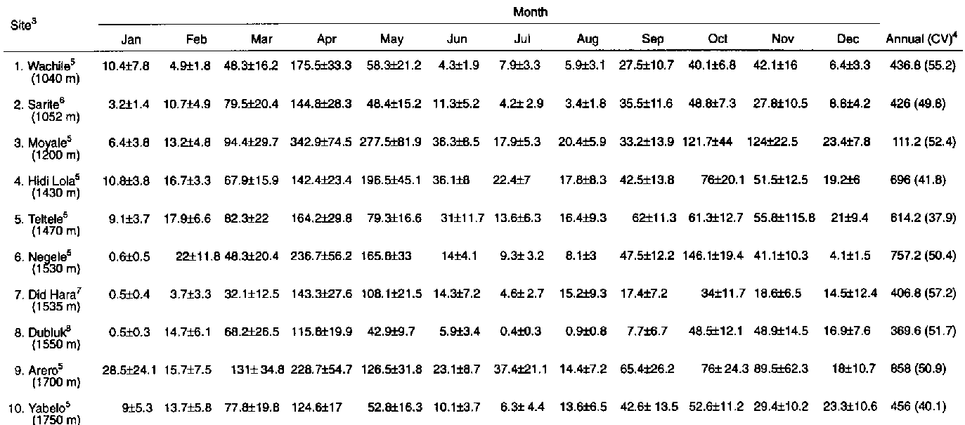
Table A1. Rainfall on a monthly end annual basis for 10 sites in the SORDU sub-project area for the period 1980-89.
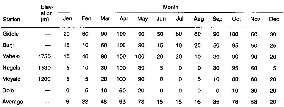
Table A2. Per cent probabilities of monthly rainfall exceeding 60 mm for six stations in southern Ethiopia as derived from data collected during 1957-1981.
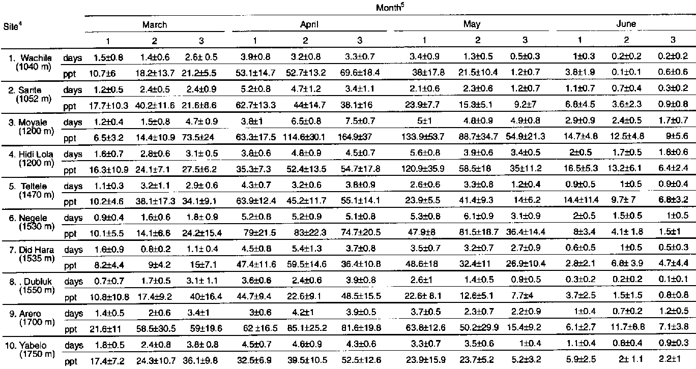
Table A3. Number of rainy days and total rainfall on a 10-day basis during the long rainy season for 10 sites in the SORDU sub-project area during 1980-89.
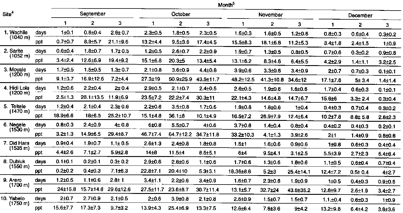
Table A4. Number of rainy days and total rainfall on a 10-day basis during the short rainy season for 10 sites in the SORDU sub-project area during 1980-89.
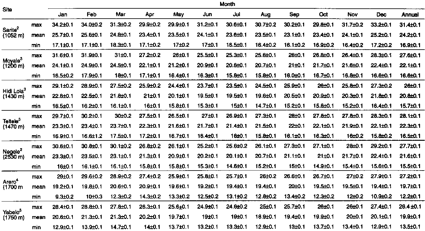
Table A5. Air temperature on a monthly and annual basis for seven sites in the SORDU sub-project area during 1980-89.
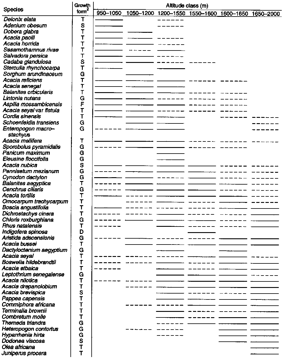
Table A6. Altitudinal distribution of 55 important plant species in the SORDU sub-project area.
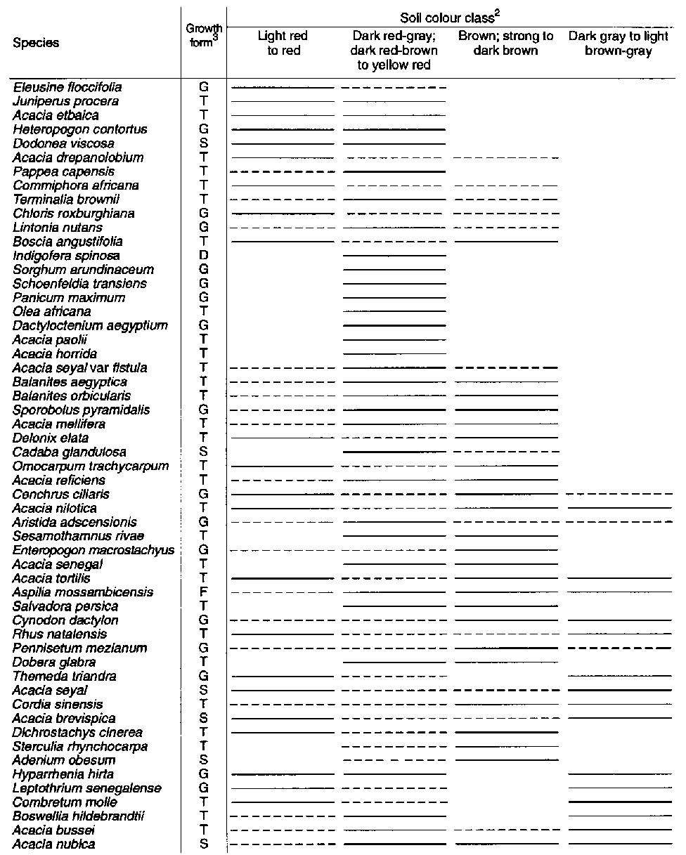
Table A7. Soil colour distribution for sites containing 55 important plant species in the SORDU sub-project area.
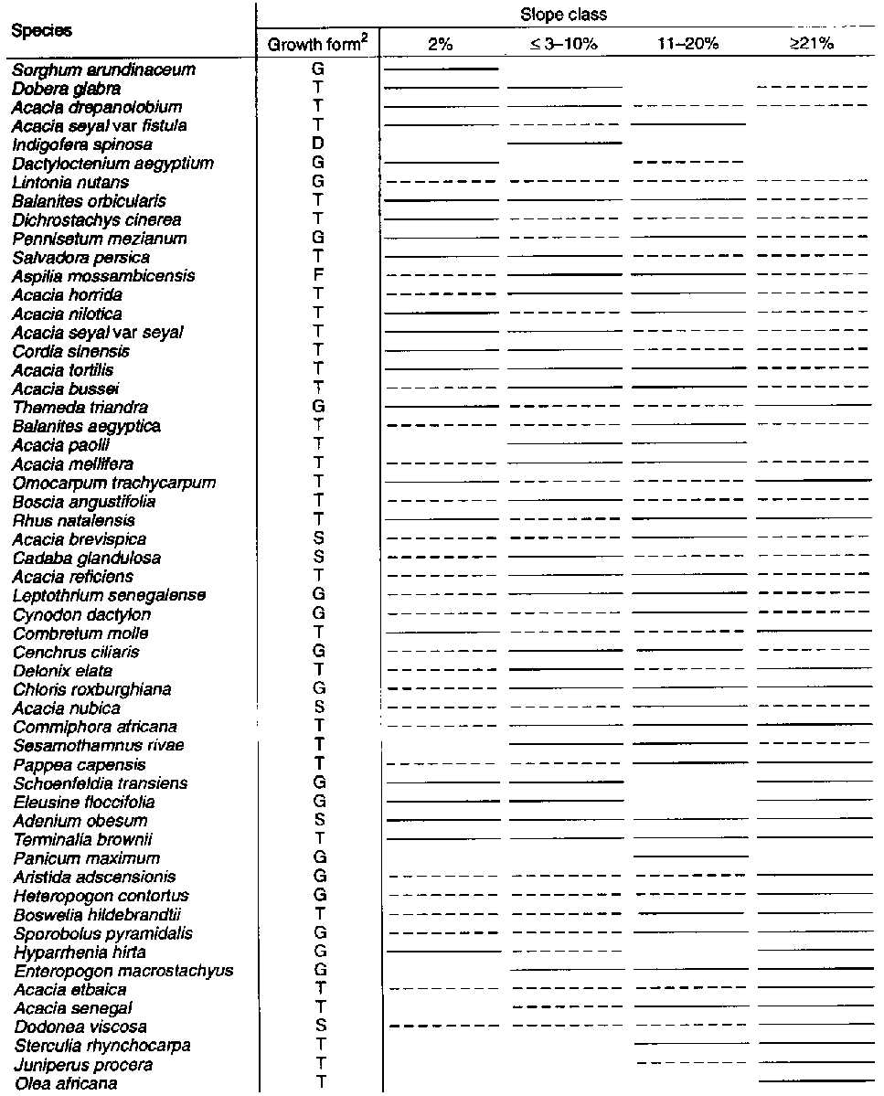
Table A8. Slope distribution of 55 important plans species in the SORDU sub-project area.
Table A9. Vegetation structure distribution for 55 important plant species in the SORDU sub-project area.
Table A10. Soil reactivity for sites containing 55 important plant species in the SORDU sub-project area.
1 Tabular entries (mm) represent the mean ± 1 standard error (SE).2 Averages are probably biased downwards because of the 1984-85 drought.
3 Sites are listed here from lowest to highest elevation (m.a.s.l.).
4 Coefficient of variaton = standard deviation expressed as a percentage of the mean. It is a measure of variability. 51980-89. 61981-89. 71980-87. 81980-84;1986-88.
Source: Raw data provided courtesy of the National Meteorological Service of Ethiopia.
1 Sixty millimeters per month is considered by Billé (1983) as the minimum required for herbaceous production in the southern rangelands. Gidole, Burji and Dolo are higher-elevation sites than Yabelo, Negele or Moyale. Exact elevations were not provided in Billé (1983).Source: Billé (1983).
1 Tabular entries (number in mm) represent means ± 1 standard error (SE).2 The data are organised by 10-day intervals per month (1, 2, 3 above).
3 The long rains (ganna mesa in the Borana/Oromigna vernacular) typically occur in late March, April and May.
4 Sites are listed here from the lowest to the highest elevation (m.a.s.l.); days = rainy days and ppt = rainfall.
5 Bordering months were also included to illustrate variability.
Source: Raw data of the National Meteorological Service of Ethiopia.
1 Tabular entries (number in mm) represent means ±1 standard error (SE).2 The data are organised by 10-day intervals per month (1,2,3 above).
3 The short rains (hagaya in the Borana/Oromigna vernacular) typically occur in September, October and November.
4 Sites are listed here from the lowest to the highest elevation (m.a.s.l.); days = rainy days and ppt = rainfall.
5 Bordering months were also included to illustrate variability.
Source: Raw data provided courtesy of the National Meteorological Service of Ethiopia.
1 Tabular entries are means ±1 SE.2 1981-89.
3 1980-89.
4 1980-86.
Source: Raw data courtesy of the National Meteorological Service of Ethiopia.
Table A6. Altitudinal distribution of 55 important plant species in the SORDU sub-project area.1
1 Based on a survey of 134 sites. Solid lines indicate greater probability of occurrence in respective altitude classes. Species are arranged from those occurring more at lower elevations (top of table) to those occurring more at higher elevations (bottom of table).2 Where T = tree, S = shnub, G = grass and D = dwarf shrub.
Source: Raw data from Corra (1986).
1 Based on a survey of 134 sites. Solid lines indicate greater probability of occurrence in respective soil-colour classes.2 Categories determined by Corra (1986).
3 Where T = tree, S = shrub, G = grass and D = dwarf shrub.
Source: Raw data from Corra (1986).
Table A8. Slope distribution of 55 important plans species in the SORDU sub-project area.1
1 Based on a survey of 134 sites. Solid lines indicate greater probability of occurrence in respective slope classes.2 Where T = tree, S = shrub, G = grass and D = dwarf shrub
Source: Raw data from Corra (1986).
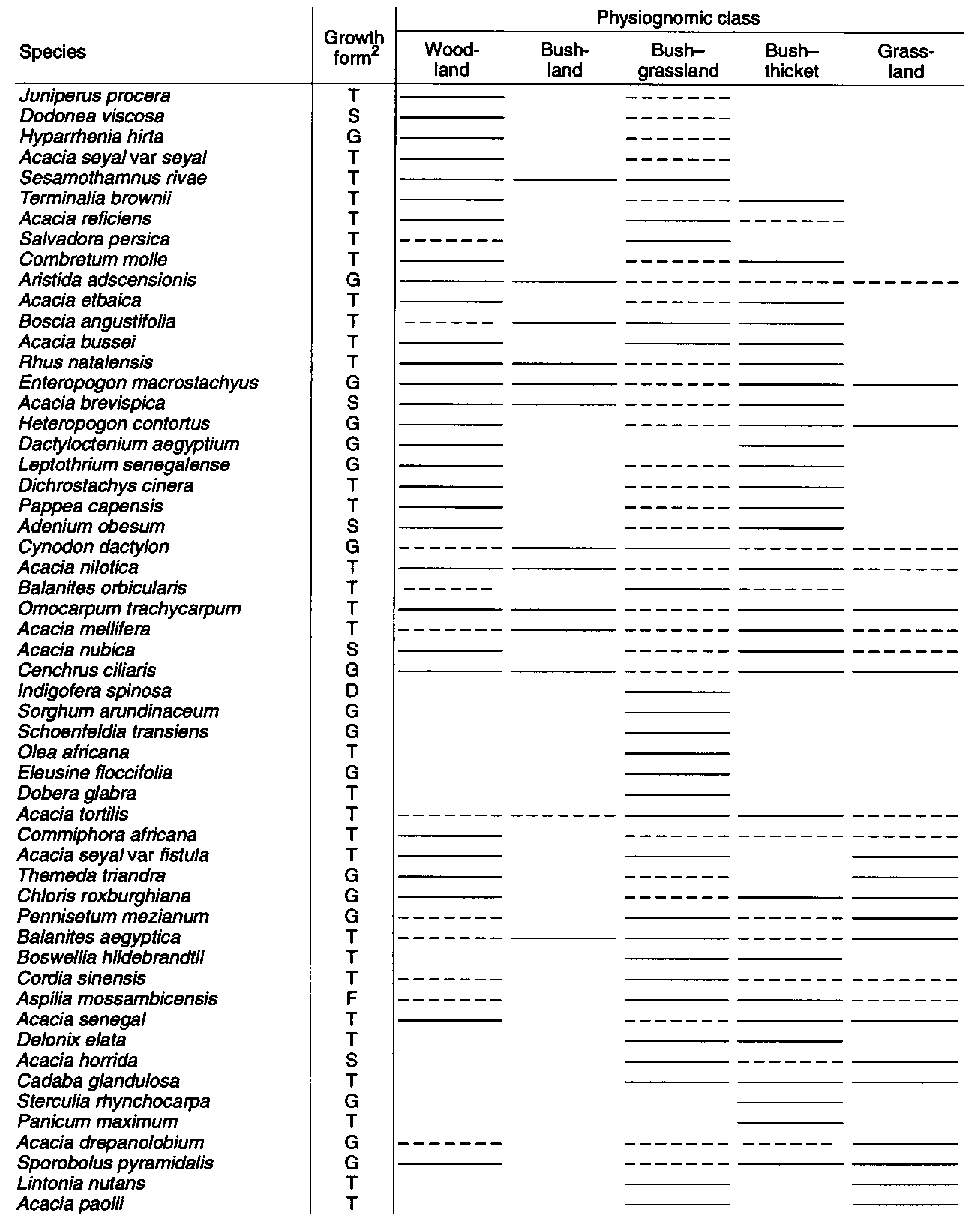
1 Based on a survey of 134 sites. Solid lines indicate greater probability of occurrence in respective physiognomic classes.2 Where T = tree, S = shrub, G = grass and D = dwarf shrub.
Source: Raw data from Corra (1986).
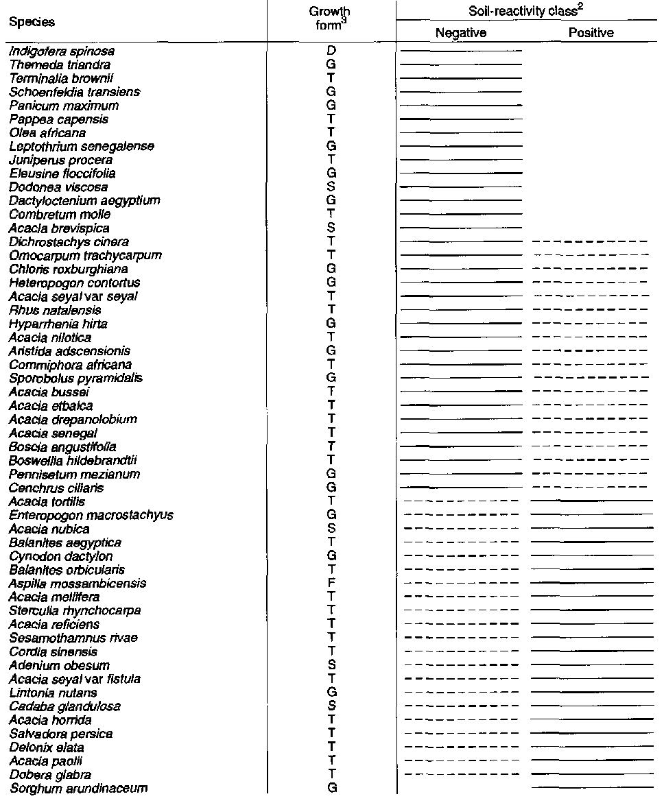
1 Based on a survey of 134 sites. Solid lines indicate greater probability of occurrence in respective soil reactivity classes.2 Reactivity of top soil to 4 M HCI. Negative values for soil reactivity occurred more at higher elevations dominated by basement-complex formations. Positive values for soil reactivity occurred more at lower elevations dominated by volcanics and mixed soils.
3 Where T = tree, S = shrub, G = grass and D = dwarf shrub.
Source: Raw data from Corra (1986).
![]()
![]()
![]()