![]()
![]()
![]()
H.D.C. Msiska
Lunyangwa Research Station
P.O, Box 59, Mzuzu, Malawi
J.T. Munthali
Chitedze Research Station
P.O. Box 158, Lilongwe, Malawi
and
B.H. Dzowela
ILCA, P.O. Box 46847, Nairobi, Kenya
Introduction
Influence of physiogeographic region
References
Appendix 1
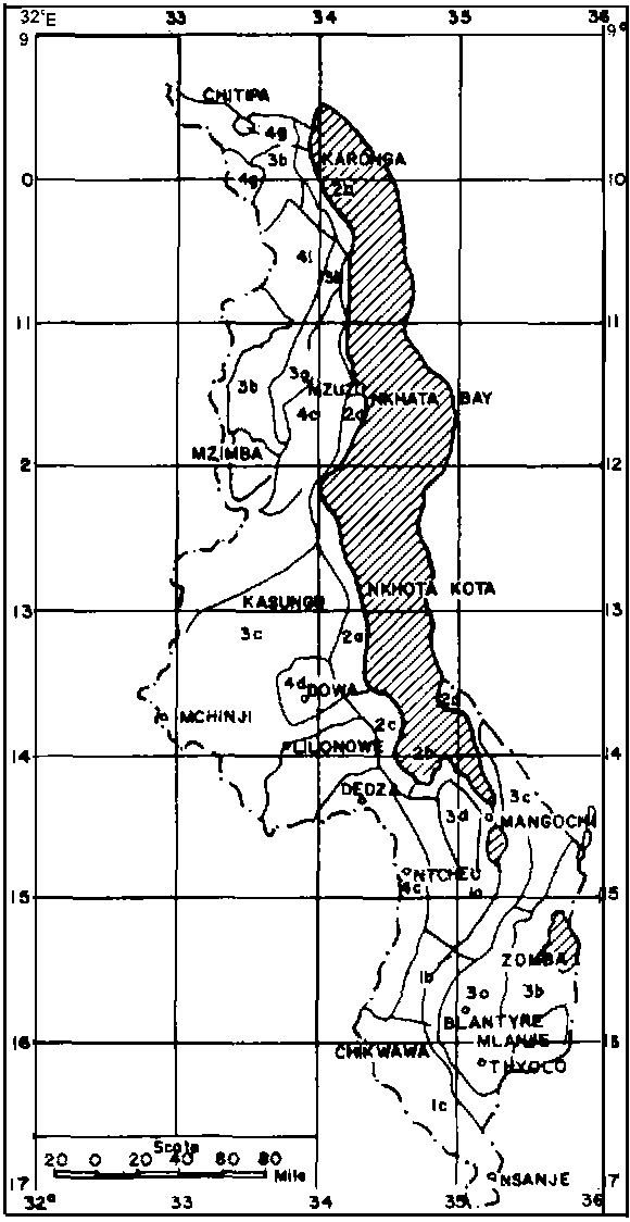
Legend of physiographic regions as shown in Figure 1.
Abstract
The occurrence of grass species of Panicum, Pennisetum, Chloris, Urochloa, Setaria and Brachiaria and legume species of Neonotonia, Macrotyloma, Dolichos, Sesbania and Aeschynomene in different physiographic regions is described. Emphasis has been put on the climatic variables which tend to influence species distribution and the physiological maturity among legume species.
Malawi, which is 94,396 sq. km, is dominated by the final section of the East African rift valley system which fractured the high south Central African plateau to form a deep trough occupied by Lake Malawi. The lake which is 570 km long and 16-80 km wide is drained by the Shire River following the line of rift into the Zambezi River (Agnew and Stobbs, 1972). The faulting and subsequent erosions created diversified topographies which have been modified by the influence of the lake, intertropical convergence zone and the southeast Trade Winds to give rise to tropical and sub-tropical environments. These environments contain a variety of grasses and legumes which could be utilised in our farming systems.
So far there has been no extensive plant collections in Malawi, and as a result detailed distribution of forage plants is rather sketchy. However, the few vegetation documents available, the 1981 collection strip made by the senior author to some parts of the central and northern regions and the knowledge of the authors has formed the bases of this paper. Consequently, some documents could have been overlooked out of ignorance.
The physiographic regions delineated by Pike and Rimmington (1965) (Appendices 1 and 2) have been used to describe the distribution of the forage plants. The climatic variables in these regions differ a lot and warrant a separate description to give a prospective collector all the necessary information.
Lower Shire Valley
This area is a narrow extension of the Mozambique Coastal Plain into Malawi with altitudes ranging from about 120 m in the north to 40 m in the south. The area lies in the rainshadows of the Thyolo escarpment in the north-west, the Nsanje Hills in the south and the watershed between the Zambezi and the Shire rivers. The average temperature and rainfall are 30°C and 630 mm respectively.
Urochloa mosambicensis, Panicum spp. Clitoria ternatea, Rhynchosia spp. and Sesbania spp. are found in this area. Urochloa mosambicensis is widespread in the valley especially on grassy areas occurring on sandy soil. This ecotype is superior to U. pullulans, a perennial found elsewhere in the country at altitude below 1500 m which tends to scorch whenever there is dry spell during the rainy season. Setaria and Panicum, Sesbania and Aeschynomene spp. grow along streams and dambos. Clitoria ternatea is found around Ngabu on gravelly soils.
Mulanje Mountains - Shire Highlands - Zomba Mountain
This region whose average altitude ranges from 610 m to 3000 m has an extended rainfall season as a result of the moisture carried by the south-east Trade Winds from the Indian Ocean. Average rainfall is about 3000 mm in Mulanje and Zomba and decreases to about 1000 mm in some parts of the Shire Highlands.
Panicum maximum occurs along roads, streams and on scattered hills of the Shire Highlands which contain Acacia woodii and Albizzia gummifera vegetation. The commonest perennial wood type has broad dark green leaves and is found growing in the heavily disturbed areas. The giant types are found mostly on the windward side whereas the medium types tend to occur on the leeward side of these highlands. Pennisetum, Setaria, Cynodon and Neonotonia spp. also occur in this area.
Central Region Lakeshore Plain
This area extends from Salima in the south to Nkhota-kota in the north. It is a relatively dry area due to the prevalence of the southeast Trade Winds which lose their moisture on the Mulanje, Shire-and Zomba Highlands. The altitude is about 500 m, and the average temperature and rainfall are 23°C and 1270 mm respectively. The area is characterised by seasonal swamps and Acacia-Adansonia-Cordyla-Sterculia vegetation - interspersed with alluvial fans along the Linthipe, Lingadzi, Bua, Kaombe, Dwangwa and Dwambazi rivers.
Panicum, Pennisetum, Cynodon, Brachiaria, Setaria, Neonotonia and Aeschynomene spp. occur in this area. Panicum maximum is found along river and swamp fringes. The P. maximum growing along the Dwangwa river could even be planted from setts. The distribution of P. maximum seems to indicate that seed originally came from higher areas of the Dowa-Ntchisi and Viphya highlands. This hypothesis is supported by the absence of P. maximum along rivers and dambos from the Chitala river going southwards, a section which does not have corresponding highlands further inland. The Cynodon spp. have head smut which limits their chance of being suitable for collections. Neonotonia wightii along the entire area shows a visual gradation from diploid to tetraploid types from south to north corresponding to the amount of rainfall received.
Dowa-Ntchisi Highlands
The area has some evergreen forests at altitudes of 1700 m due to the influence of orographic rains brought by the southeast Trade Winds. Panicum maximum, Setaria spp. Pennisetum purpureum and Neonotonia wightii are found in this area.
Past collections from this area yielded Panicum maximum cv Ntchisi. This giant guinea grass has broad bluish green leaves which makes it suitable for cut-and-carry, silage and grazing (Addy and Thomas, 1976). Ntchisi panic has found its way into Kenya (Bogdan, 1977) and Zambia (Anon., 1979). Ntchisi panic like most guinea grasses is mostly propagated by splits because seed harvesting is hampered by variability in seed maturation on the same panicle which quickly sheds or are eaten by birds.
Central Region Plateau
The central region plateau is the largest continuous surface in Malawi extending from the margin of the rift valley in the east to the Zambian border in the west. The altitude ranges from 970 to 1300 m with an average temperature and rainfall of 20°C and 800 mm respectively.
The vegetation consists of Acacia-Piliostigma-Combretum and Brachystegia-Julbernardia savannah woodlands on the Lilongwe and Kasungu plains respectively. Panicum maximum occurs along major rivers of Lilongwe, Lingadzi and Bua whereas Brachiaria spp. Setaria sphacelata, S. longiseta and S. splendida are found both on higher ground and dambos. Setaria palustris is found on dambos only. Most of these Setaria spp. are attacked by head smut (Tiletia echnosperma).
Macrotyloma spp. occurring on the Lilongwe plain consist of both annual grabrescent and pubescent types. The grabrescent type climbs onto the hyparrhenia and maize plants. This climbing attribute onto the latter could be utilised to improve the quality of maize stover for stall-feeding. Macrotyloma axillare occurs on the Kasungu plain but its small leaves would limit its usefulness as a forage legume. Neonotonia spp. which matures towards the end of the rainy season occurs throughout this region especially on termite mounds.
Viphya Lakeshore and Highlands
The altitude ranges from 500 m on the lakeshore to about 1300 m on the highlands. This region, apart from the Mulanje-Shire-Zomba highlands, receives the next highest annual rainfall of over 1500 mm. The southeast Trade Winds, after blowing over the lake for a long distance, get recharged with moisture which falls as orographic rain. As a result of this influence, this region has an extended rainy season which supports growth of low altitude evergreen forests on the lakeshore and on the highlands. The Luweya catchment area, the area between Chintheche and NkhataBay and extending westwards to Mzuzu, has the largest variety of Panicum and Brachiaria spp. compared to any other area in Malawi. In contrast, the northern Viphya Highlands contain relatively few of these grasses probably due to the rainshadows created by Choma and Chimaliro hills within the highlands. Setaria and Pennisetum spp. also occur in this area. Most of these species are found along streams and on the extensive Limphasa dambo. The heavily smutted Cynodon spp. are found on the lakeshore only.
Neonotonia, Dolichos and Macrotyloma spp. occur in this region. Among Neonotonia spp. are found both early and late maturing ecotypes. The latter flower as late as August at the onset of the dry hot season when wild fires are very common. The slender pubescent Macrotyloma sp. is found on the lakeshore along gullies whereas Macrotyloma axillare and the shrub type Macrotyloma sp. occur on the highlands. M. axillare distribution seems to indicate that it thrives well on well drained sandy loam soil.
The Henga - Lower Kasitu Valley
The region lies between the Viphya to the west and Nyika plateau and Njakwa Hills to the east. The altitude is over 1000 m with an average temperature and rainfall of 21°C and 760 mm respectively. The vegetation consists of the Brachystegia-Julbernardia and Combretum-Acacia woodlands. Chloris gayana, Cynodon spp., Panicum spp. and Neonotonia spp. occur in this area. Most Cynodon spp. have head smut. Neonotonia spp. mature early in May-June at the onset of the cool dry season.
The Mzimba Plain
Most of the area lies in the rainshadows of the Viphya highlands, the Nyika plateau and the Njakwa Hills. The vegetation consists of the Brachystegia-Julbernardia woodland. The altitude is about 1200 m and the average temperature and rainfall is 20°C and 760 mm respectively.
Chloris gayana, Panicum spp., Cynodon spp., Pennisetum spp., Neonotonia spp. and Clitoria ternatea occur in this area. No collections of Chloris gayana have been made despite its wide acceptance for grazing and hay making. However, Vwaza Game National Park will remain the major area for future collections whereas in settled areas termite mounds will be the best spots. Large patches of Cynodon spp. in the Nkhamanga and Hewe areas occur along rivers and low lying areas. Panicum maximum is mostly found along the Rumphi and Runyina rivers. Clitoria ternatea is found at Rumphi boma.
Nchenachena-Livingstonia Hills
The area lies on the eastern slopes of the Nyika at an average altitude of 1400 m and is characterised by cool weather and an extended rainy season due to the influence of the southeast Trade Winds. The average annual temperature and rainfall is 20°C and 1700 mm respectively.
Neonotonia and Dolichos spp. occurring in this area mature late in September-October at the onset of the short hot dry season. The largest concentrations of Neonotonia spp. occur between Junju and Kaziwiziwi where it is possible to find plants 20 m apart. Medium and giant Panicum maximum are concentrated along rivers and valley bottoms. Cynodon spp. occurs at Rumphi North bridge and around the Livingstonia plateau.
The Nyika Plateau
The plateau lies between 2,000-3,500 m and receives about 1270 mm rainfall. The average temperature is about 14°C. Setarias and Macrotyloma spp. are the only important forage species found on the plateau. The Setaria because of the altitude have very small leaves and may not be suitable for collections. Two types of Macrotyloma spp. occur in the plateau - the grabrescent type found in the open grasslands and the slender pubescent type is found among the dense thickets along valleys. Kikuyu grass (Pennisetum clandestinum) introduced from East Africa has almost been naturalised on the plateau.
The Karonga Lakeshore Plain
The lakeshore plain average altitude is about 550 m. The average temperature and rainfall are 25°C and 920 mm respectively. Setaria, Panicum and Brachiaria spp. occur along channels in the Hara, Wovwe and Lufilya rice schemes, the dambos through which some major rivers from the Nyika plateau pass. Cynodon spp. on this plain are severely attacked by head smut. Calopogonium sp., growing around the Lufilya rice scheme, is a recent introduction by the Chinese agricultural technicians for green manuring.
The Chitipa-Lufilya Plain
The plain lies at an altitude of 1500 m. The average temperature and rainfall are 20°C and 1000 mm respectively. Panicum, Cynodon and Neonotonia spp. occur in many areas especially along the drainage systems. Large concentrations of Panicum maximum are found at Chisenga, at the foothills of the Mafingi Hills, and a few plants are scattered along the Kaseye and Lufilya rivers. Neonotonia wightii is found along the Kaseye and Songwe rivers, and most of these mature in July. Cynodon spp. are widely distributed on the Chitipa plain especially on sandy soils where they form large patches of natural pastures. No head smut was observed on these Cynodon spp.
The Misuku Hills
The hills rise to an altitude of 2000 m. Due to the influence of the south-east Trade Winds, the area is covered by moist Brachystegia woodland, semi-evergreen forests and montane grassland forests. The average temperature and rainfall are 21°C and 100 mm respectively. Neonotonia wightii, with a lot of hairs, occurs in this area and matures late in September. A Calopogonium sp. introduced by earlier agriculturalists grows around Misuku Agriculture Station. There are few Panicum and Brachiaria spp. in this area probably due to extensive cultivation in this densely populated area. Cynodon spp. occurs in scattered areas.
Summary and Conclusions
Panicum species tend to occur more in wet and fertile areas with high frequencies than in dry areas especially on the leeward side of high grounds. Neonotonia wightii also tends to follow the same pattern except that occurrence is also high in wet fertile areas. Chloris gayana, Urochloa mosambicensis, Brachiaria spp. Dolichos spp. and Macrotyloma spp. have special habitats. Therefore, with the present knowledge it is possible to make trips to targeted areas to collect specific species.
Addy, B.L. and Thomas, D. 1976. The utilization of Ntchisi panic and Katherine pearl millet for summer stall feeding in Lilongwe district. Ministry of Agriculture and Natural Resources Bulletin No. 1/76, Lilongwe, Malawi.
Agnew, S. and Stobbs, M. 1972. Malawi in maps. Oxford University Press, London.
Bogdan, A.V. 1977. Tropical pasture and fodder plants. Longmans, London.
FAO. 1979. A Zambian handbook of pasture and fodder crops. Food and Agriculture Organization of the United Nations, Rome.
Pike, J.G. and Rimmington, G.T. 1965. Malawi, a geographical study. Oxford University Press, London.
Figure 1. Physiographic Regions of Malawi.
1a - The upper shire valley
1b - The middle shire valley
1c - The lower shire valley
2a - The South-eastern Lakeshore
2b - The Southern Lakeshore
2c - The South-west Lakeshore
2d - The Nkhota-kota Lakeshore
2e - The Viphya Lakeshore
2f - The Karonga Lakeshore
3a - The Shire Highlands
3b - The Lake Chilwa
3c - The Namwera Hills
3d - The Chitipa Plain
3e - The Central Region Plateau
3f - The Mzimba Plateau
3g - The Henga-Kasitu Valley
3h - The Nchenachena
3i - The Chitipa-Lufilya Plain
4a - Mulanje Mountains
4b - Zomba Mountain
4c - The Dedza-Kirk Range Highlands
4d - The Dowa Highlands
4e - The Viphya Highlands
4f - The Nyika Plateau
4g - The Mafingi Mountains
4h - The Misuku Highlands
![]()
![]()
![]()