![]()
![]()
![]()
1.1. Introduction
1.2. The highlands of sub-Saharan Africa and the Ethiopian highlands
1.3. The agricultural systems of the Ethiopian highlands
1.4 Previous agricultural research and development in Ethiopia
1.5 Land tenure system
This study summarizes the research of the ILCA Highlands Programme from its inception in 1976 to the end of 1980. In this chapter the background to the research is presented: the importance of the highland zone in sub-Saharan Africa is outlined in Section 1.2; Section 1.3 describes the Ethiopian highlands from an agricultural systems standpoint; previous experiences of research and development activities in the Ethiopian highlands are summarized in Section 1.4; and Section 1.5 provides an overview of the land tenure system in Ethiopia.
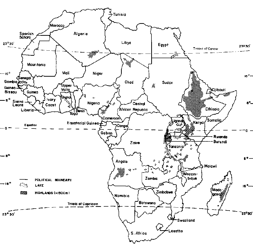
The highlands of sub-Saharan Africa, defined as areas above 1500 m elevation or with mean daily temperatures of less than 20°C during the growing period, include approximately 1 million km² or some 4% of the land area of sub-Saharan Africa. About 75% of the highlands are located in eastern Africa. In Ethiopia, Kenya and Tanzania they account for the great majority of the human and livestock populations. Rwanda, Burundi, Zaire, Chad, Somali, Cameroon, Angola, Malawi, Uganda, Zambia and Madagascar also have large highland areas. The distribution of highland areas in Africa is illustrated in Figure 1.1.
Although the highland zone is a small fraction of the land area of sub-Saharan Africa, it accounts for large human and livestock populations and has a considerable agricultural potential. Almost 20% of the rural human and ruminant livestock populations of sub-Saharan Africa are found in the highlands. The human population density of approximately 44 persons per km² is higher than in any other agroclimatic zone. The stocking density also is almost four times the average for sub-Saharan Africa as a whole. Table 1.1 summarizes the human and livestock population densities of the various zones in sub-Saharan Africa.
As indicated in the table, the highlands have a human population density more than double the average of sub-Saharan Africa as a whole. Several factors contribute to the concentration of people and their livestock in the highlands, including favourable climates and ecological conditions for smallholder mixed crop/livestock farming (good soils, moderate temperatures, ample radiation and rainfall), comparatively high levels of fodder production, and the absence of trypanosomiasis. While productivity levels of crops and livestock in the highlands are higher than at lower altitudes and in lower rainfall zones, the concentration of people and their crops and livestock over many centuries has resulted in substantial erosion problems and declining soil fertility in many areas.
Subsistence smallholder mixed farming prevails generally throughout the highlands, with crop and livestock husbandry typically practiced within the same management unit. Despite the zone's good agricultural potential, cropping is limited in large areas by harsh agroclimatic conditions, such as aridity or coldness (Jahnke, 1982). The highlands are a complex zone, characterized by wide diversities of climate, topography, development potential and land use. As a result, considerable differences in settlement and land-use density occur. For example, Rwanda and Burundi have extensive highland areas and national population densities of 160 to 185 persons per km². A detailed study on the agroclimatology of the highlands of eastern Africa is presented by Brown and Cochemé (1973).
Ethiopia has the largest highland area of the continent, covering 490 000 km², or around 40% of the country and almost half the total African highland area. It was therefore the initial focus of ILCA's highlands research, although the programme has a wider African perspective.
Figure 1.1. The highlands of sub-Saharan Africa.
Source: Adapted from Amare Getahun (1978a).
Ethiopia's highland topography is rugged and complex. The central part of the country is mostly high plateau, at least 1500 m above sea level with peaks rising to more than 4000 m, and is dissected by gorges and broad valleys. This plateau culminates in the east in a coastal plain spreading to the Red Sea, and in the west in the White Nile Valley plain on the Sudanese border. Most of these lowland plains are extensive rangelands inhabited by nomadic pastoralists.
Ethiopia's rugged terrain is a major constraint to economic development because of the inherent transport and communication problems. Half to three quarters of the population lives more than a day's round trip walk from an all-weather road.
The population of Ethiopia, estimated at 31 million in 1979, is growing at about 2.5% p.a. About 85% of the people live in the rural areas, and the highlands account for about 70% of national human and livestock populations. GNP in 1978 was estimated at US$ 3.5 billion, and overall per caput income is around US$ 110 p.a. Ethiopia is classified by the United Nations as one of the 25 least developed countries in the world. Almost one quarter of its children die before they are 4 years old. Only 6% of the population has access to safe water, the average daily calory supply is only 75% of requirements, and life expectancy at birth is 40 years (IBRD, 1981). In many rural areas, people are acutely vulnerable to drought and starvation. Furthermore, basic social services are seriously deficient. Until 1979 well over 90% of Ethiopia's population was illiterate, although many people have since benefitted from the national literacy campaign.
Table 1.1. Land area, human population and livestock densities by agroclimatic zone in sub-Saharan Africa.
|
Zone |
Area ('000 km²) |
% of sub-Saharan Africa |
Rural human population ('000) |
% of sub-Saharan Africa |
Rural population density (persons/km²) |
LUa ('000) |
% of sub-Saharan Africa |
Stocking density (LU/km²) |
|
Arid |
8 327 |
37.3 |
12 000 |
5.3 |
1.7 |
41 697 |
30.4 |
5.0 |
|
Semi-arid |
4 050 |
18.1 |
61 240 |
27.0 |
14.8 |
37 446 |
27.3 |
9.2 |
|
Humid |
4 137 |
18.5 |
63 700 |
28.0 |
15.0 |
8 149 |
5.9 |
1.9 |
|
Subhumid |
4 858 |
21.7 |
46 260 |
20.3 |
9.4 |
26 370 |
19.2 |
5.4 |
|
Highlands |
990 |
4.4 |
44 000 |
19.4 |
44.2 |
23 646 |
17.2 |
23.9 |
|
|
22 362 |
100.0 |
227 200 |
100.0 |
10.7 |
137 308 |
100.0 |
6.1 |
a One LU is equivalent to a ruminant animal of 250 kg liveweight.
Source: Adapted from Jahnke (1982).
The agricultural sector, since 1970 growing at only 0.4% p.a., contributes almost half of the country's GNP, and agricultural exports account for over 90% of total export earnings. Ethiopia has the largest livestock population in Africa, with approximately 26 million head of cattle, including around 6 million draught oxen, 24 million sheep, 18 million goats, 7 million equines, 1 million camels and 52 million poultry (de Montgolfier-Kouévi, 1976).
Livestock and livestock products contribute 35% of agricultural output and additionally supply the power to cultivate virtually all of Ethiopia's 6 million ha of land cropped annually. Livestock (mainly donkeys) also contribute substantially to rural transport needs. Exports of livestock products are presently limited to hides and skins, but a great potential exists for exports of beef, mutton and goat meat to the Middle East countries.
Less than 10% of the country is regularly used as cropland, 55% are grasslands or permanent pastures, 4% are swamps, 7% forests and the remaining 24% are barren, waste and other land.
The major crops grown are teff (Eragrostis tef), barley, horse beans, maize, sorghum, wheat and coffee. Since the mid-1970s, rural development has been organized within a socialist framework. However, collective farming through cooperatives and state farms accounts for less than 5% of the total area cultivated. Over 90% of agricultural output is still produced by individual subsistence smallholders who have "farming rights" over the land they till.
Agricultural conditions vary widely in the different ecological zones of Ethiopia, according to topography, climate, soils and natural vegetation. Climatologically, the country can be divided into six regions: the arid tropical, the dry equatorial, the semiarid equatorial, the humid equatorial, the highland equatorial and sub-equatorial regions. The last two regions constitute the target zone of the ILCA Highlands Programme.
1.3.1 The high-potential cereal/livestock zone
1.3.2 The low-potential cereal/livestock zone
1.3.3 The high-potential horticulture/livestock zone
Several authors (among others, Huffnagel, 1961; Westphal, 1975; Amare Getahun, 1978a and b) have described the traditional agricultural systems of the Ethiopian highlands. On a technical basis, Westphal identified four distinct systems: seed-farming, ensete (false banana) planting, shifting cultivation and pastoralism. However, from an economic viewpoint the development potential and the resource base of the various highland regions is more important. In this regard Amare Getahun (1978a) differentiated the high-potential cereal/livestock zone, the low-potential cereal/livestock zone and the high-potential horticulture/livestock zone. The principal characteristics of these major agro-ecological zones are summarized in Table 1.2.
The high-potential cereal/livestock zone is the most important in terms of human and livestock densities and the production of food crops. An adequate natural resource base exists for increased crop and livestock production, but social and economic infrastructures are poorly developed. The zone is also undergoing ecological degradation because of increasing human and livestock population pressures combined with the use of traditional agricultural technologies. Efforts to halt or reverse this trend are urgently needed. Throughout the zone a simple, ox-drawn ard, known locally as a maresha, is the main agricultural tool.
This zone comprises the central highlands, the Arsi - Bale massifs, the Harar highlands, the northeastern highland valleys and the Lake Tana basin. The productivity of agriculture, which is based on cereals, oilcrops, pulses, ensete and livestock, could be improved considerably throughout the zone, but it is the central highlands area, the most important agricultural area of Ethiopia, which has the greatest potential. Here gains are expected to be easier to achieve in the livestock than in the crop component. Water-logging problems, a lack of response to inorganic fertilizer, and severe erosion are major impediments to achieving productivity increases in crops. On the other hand, the mild climate of the central highlands favours the introduction of higher-yielding crossbred animals and is suitable for the cultivation of forage crops, allowing productivity increases to be achieved through livestock. This central highlands area has therefore been the focus of ILCA's research.
In the Arsi - Bale massifs, covering approximately 34 400 km², livestock husbandry has traditionally dominated agricultural activities, but with the recent influx of Amhara farmers from the north crop cultivation has become more important, such that mixed farming now prevails. The area has benefitted substantially from an intensive rural development programme, which is discussed in more detail in Section 1.4.
Agriculture in the Harar highlands is dominated by sorghum and beef cattle production. This part of the high-potential cereal/livestock highlands is relatively well served with transport and marketing services.
The northeastern highlands and the Lake Tana basin are comparatively small and uniform areas of 6600 km² and 10 000 km² respectively. Both have a considerable potential for increases in crop and livestock productivity, but flood control, erosion and deforestation are important problems in the northeastern highlands. In the Lake Tana basin the major obstacles to development are poor drainage, animal diseases and parasites. The incidence of malaria and bilharzia in the human population is high.
Table 1.2. Characteristics of the major agro-ecological zones in the Ethiopian highlands.
|
Characteristic |
Zone |
||
|
High-potential cereal/livestock |
Low-potential cereal/livestock |
High-potential horticulture/livestock |
|
|
Area (km²) |
140 300 |
162 920 |
186 300 |
|
Population density (persons per km²) |
34 |
32 |
33 |
|
Livestock density (head per km²) |
53 |
28 |
32 |
|
Climate |
Humid/subhumid |
Subhumid/semi-arid |
Humid |
|
Topography |
Rolling plateaux |
Mountains/escarpments/low plateaux |
Dissected plateaux |
|
Main crops |
Cereals/pulses/livestock |
Cereals/pulses/livestock |
Tree crops/livestock |
Source: Amare Getahun (1978a).
The low-potential cereal/livestock zone consists of two regions, the degraded high-altitude highlands which are climatically part of the high-potential cereal/livestock zone, and the plateaux and escarpments lying between the lowlands and the more temperate highlands. Human and livestock pressures are high relative to the ressource base, but some out-migration is taking place to other highland systems. Crop yields are low and there is an acute shortage of arable land and productive pastures. Steep and rugged sites are cultivated, aggravating erosion. In many areas the problems of soil conservation are acute and new settlements should be discouraged and minimized. The existing agricultural resource base is deteriorating rapidly. Again, the maresha is the main agricultural tool.
The high-potential horticulture/livestock zone has high annual rainfall, an extended wet season and a moderate, warm climate. Social and economic infrastructures are poorly developed. Perennial crops such as coffee and tea are important, while ensete, root crops and maize are the principal food crops. Horticulture and chat (Catha edulis) production are also important. This zone is attracting government attention for potential resettlement programmes and commercial agricultural development. Quite high numbers of cattle are kept, but the number of small ruminants is low. The hoe is the main agricultural tool.
The first efforts by the Ethiopian Government to establish agricultural research and experimental facilities date from 1952. However, agricultural research in Ethiopia was not institutionalized until 1966, when the Institute of Agricultural Research (JAR) was set up. The IAR was given official responsibility for the sponsorship and coordination of all agricultural research, and now has eight research stations in the country.
Although the Ethiopian Ministry of Agriculture was established at the beginning of this century, it was not until the early 1950s that attempts were made to transform traditional peasant agriculture. Most of these attempts have used the "package" approach, although the initial focus was on the development of commercial farming. The major components of the package programmes have included fertilizers, improved seeds, farm credits, marketing facilities, better tools and implements, and improved storage facilities.
The basic aim in the package approach was to accelerate agricultural development by concentrating inputs and activities in geographically delimited regions (Stahl, 1973). A partial list of these intensive regional agricultural development projects is given in Amare Getahun (1977).
The first comprehensive package project established in Ethiopia was the Chilalo Agricultural Development Unit (CADU). This project began in 1967 and was financed jointly by the Ethiopian and Swedish Governments. It included research, extension, marketing aspects and credit and input supply schemes for smallholders. Its main impact was to show that significant increases in cereal yields were feasible through the use of fertilizer. Farmer extension services were an integral part of CADU's activities. Other similar projects were started in later years, but it was realized that implementing them throughout the whole country would not be feasible because of the high manpower needs and costs involved. Then, as now, Ethiopia had insufficient highly qualified staff to service adequately the needs of millions of farmers. These package programmes also fostered regional economic inequalities.
As a result of these disadvantages, the Minimum Package Programmes (MPPs) were initiated. In 1971 the Extension and Project Implementation Department (EPID) was established in the Ministry of Agriculture, with the general aim of increasing the production of peasant farmers by implementing the MPPs. The programmes were funded by the World Bank through a credit from the IDA (International Development Association). Most of the target farmers for these programmes were, however, located close to all-weather roads. Furthermore, the MPPs have concentrated on crop improvement, and to date the livestock component on farms has received comparatively little attention from researchers or developers despite its importance to the Ethiopian economy. Some research has been done on specific topics such as nutrition and breeding at the JAR, but little attention has been given to improving the overall farming system by developing the livestock component as an integral part of the farm.
The pre-revolution land tenure system was very complex, differed regionally and was closely linked with the political power structures and social class organization existing at the time. Various authors, including Goericke (1979), have studied the pre-revolution system. Three main forms of land tenure could be identified: a form of communal tenure in the north of the country, individually owned land in the centre and south under a landlord/tenant system based mainly on sharecropping, and government- or church-owned land.
Since the political revolution in 1974, the Ethiopian Government has transformed the institutional and social basis of production in agriculture. The Land Reform Proclamation of 1975 dissolved all existing tenancy relationships and abolished private land ownership. All rural land became "the collective property of the Ethiopian people". The institutional vehicle to implement these reforms were the Peasant Associations (PAs) that were established by the same proclamation.
Each PA has 200 to 400 farm families with a total land area of around 800 ha. PAs are given wide administrative and judicial powers to redistribute the land, organize cooperatives and build rural institutions such as clinics and schools. By late 1980, over 25 000 PAs had been established with more than seven million members.
Government policy is to promote cooperative modes of production, but to date most land is still allocated individually. Farmers can therefore still be considered as individual smallholders, although most PAs also set aside a portion of their land as a cooperative farm. Individual farm units, comprising several plots, range from 1 to 5 ha depending on family size, local population density and the policies of the local PA. Distribution of land takes into account the different fertility levels of the soils within the land area of the PA. This policy, although fair in principle, has in practice contributed to the fragmentation of each farmer's cropping area.
![]()
![]()
![]()