![]()
![]()
![]()
Location
Climate
Vegetation
Central Mali, defined as the area of the country between latitudes 12° and 16° N. was the area of study covered by this report. Most of the detailed work was carried out using Niono (14°15' N. 6°0' W) as the centre of operations. Niono is the location of the Station d'Elevage et de Recherches Zootechniques du Sahel, one of the research stations operated by the Livestock Division of the Malian National Institute for Research in Livestock Production, Forestry and Hydrobiology. This station was used as a base by the ILCA research team, and ILCA scientists collaborated with the government staff throughout the period of the study. Most of ILCA's field work was carried out off-station among traditional livestock producers. Most herds studied were within a 40-km radius from Niono except for three situated at Ségou, some 120 km to the south. Additional specific studies were undertaken for varying periods of time throughout central Mali.
Central Mali has a Sahelian-type climate characterised by highly seasonal, unimodal rainfall falling mainly in the period from June to September. Precipitation is highest in late July or early August. The long-term (1930-1976) average annual rainfall at Niono is about 550 mm, but since the start of the notorious Sahel drought of 1968 to 1973, the rainfall has been considerably less. During the 1978-1983 study period the annual average rainfall was less than 400 mm; details (averaged for five stations within 40 km of Niono) are given in Table 1. Occasional minor falls of rain in months other than those shown in the table are ignored, as this rain does not contribute to primary production.
Mean temperatures in the area vary from a high of 31°C in May and June to a low of 23°C in January. Humidity is highest in June and throughout the rainy period of July to September; it is lowest in February and early March. A climatic diagram for Niono, which can be considered typical of much of the central Mali area, is given in Figure 10. Fuller details of the rainfall regime of the area can be found in Wilson et al (1983).
In the south of the study area, where annual rainfall is generally in excess of 800 mm, the vegetation is a typical north-Sudanian deciduous woodland with many Combretaceae (Terminalia acroptera, T. avicennioides, Combretum ghazalense) and Leguminosae in the tree layer. Tree density is of the order of 150-3000 per hectare with a canopy cover of 20 to 50%. A feature of this zone is the large number of economically useful species retained within the agro-sylvo-pastoral system, such as Parkia biglobosa (the locust bean tree), Butyrospermum parkii (the shea-butter nut or karité tree) and Adansonia digitata (the baobab tree). The last is an introduction in this zone and is valued for its bark (for string-making), for its leaves (dried and used as a vegetable) and for a variety of other uses. The herbaceous layer is composed of medium to tall perennial and long-cycle annual grasses, including Sporobolus pyramidalis, Andropogon gayanus, A. pseudapricus, Diheteropogon hagerupii and Loudetia togoensis. Primary production of the herbaceous layer is of the order of 3.5 t DM/ha.
In the central zone of 300 to 600 mm annual rainfall, some Combretaceae remain in the tree layer but there is, as one moves north, a greater dominance of thorny Leguminosae, including Pterocarpus lucens, Acacia seyal, A. laeta and Dichrostachys cinerea. Sclerocarya birraca and Anogeissus leiocarpus are important in the southern part of this central zone. On sandy terraces, Acacia albida is a conspicuous component of the woody flora and is much valued as a provider of dry-season forage of high protein content. The number of trees per hectare varies from 500 to 2000, with a canopy cover of 5 to 15% in the north. Grasses are mainly annuals, including Elionurus elegans, Schoenefeldia gracilis and Chloris prieurii, with a maximum standing crop biomass (SCB) of 2500 kg DM/ha in the south and 1200 kg DM/ha in the north.
Table 1. Rainfall for Niono, 1977-1983.
|
Month
|
Rainfall (mm) |
Mean
|
||||||
|
1977 |
1978 |
1979 |
1980 |
1981 |
1982 |
1983 |
||
|
May |
21.8 |
3.6 |
28.7 |
7.3 |
31.0 |
9.8 |
0.0 |
14.6 |
|
June |
40.3 |
32.4 |
68.7 |
40.4 |
40.8 |
41.4 |
2.3 |
38.0 |
|
July |
77.5 |
162.6 |
78.9 |
96.1 |
107.6 |
60.6 |
45.7 |
89.9 |
|
August |
177.3 |
149.2 |
141.4 |
122.2 |
171.9 |
179.7 |
102.2 |
149.1 |
|
September |
67.2 |
90.1 |
85.3 |
66.5 |
13.0 |
46.0 |
15.1 |
54.7 |
|
October |
0.0 |
10.8 |
7.9 |
9.7 |
0.0 |
0.0 |
0.0 |
4.1 |
|
Total |
384.1 |
448.7 |
410.9 |
342.2 |
364.3 |
337.5 |
165.3 |
351.9 |
In the north-Sahelian zone where annual rainfall is below 300 mm, taller trees are replaced by shrubby growth, including many thorny species and some Euphorbiaceae. Typical species are Grewia bicolor, Boscia senegalensis, Maerua crassifolia and Acacia tortilis. The maximum number of trees per hectare is 500, with a canopy cover not exceeding 10%. The field layer is dominated by short-cycle annual grasses including Eragrostis tremula, Cenchrus biflorus, Aristida mutabilis and Tragus bertheronianus. One of the few perennials on dune sands is Panicum turgidum. The SCB of the field layer does not exceed 800 kg DM/ha.
In central Mali, the vegetation pattern is complicated by the complex geomorphology of the so-called 'dead' delta and the present inundation zone of the Niger river, also known as the 'live' delta. Fuller details of vegetative composition and primary productivity can be found in Wilson et al (1983).
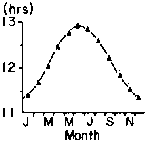
Climatic normals for the Niono area, 1930-1976.
Figure 10a. Rainfall
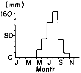
Figure 10b. Maximum and minimum temperature
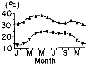
Figure 10c. Maximum and minimum RH
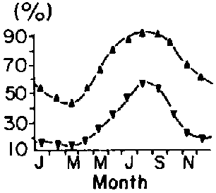
Figure 10d. Day length
![]()
![]()
![]()