![]()
![]()
![]()
3.4.1 The north coast
3.4.2 The east coast
3.4.3 The Joint Fishing Zone
3.4.4 Review of survey results for Trinidad and including the Joint Fishing Zone
Introduction
The shelf off the “four coasts” of Trinidad, south, east, north and west coasts are affected by different ecological regimes: the Colombus Channel in the south can be considered an extention of the Orinoco Delta and is dominated by the seasonal discharges of this great river. Under an agreement with Venezuela this part is defined as a “Joint Fishing Zone south of Trinidad and north of Venezuela”. The Orinoco regime extends up along the inner parts of the east coast shelf, but its more offshore parts are covered by the Guiana Current. The north coast shelf is located at the start of the Caribbean Current with its inshore upwelling system and relatively high productivity. Finally there is the Gulf of Paria off the west coast with its special shallow water system.
The objectives pursued in Trinidad & Tobago waters varied between the surveys. The north coast shelf was surveyed twice, in May and November. The east coast shelf was covered in all four surveys, but with different objectives and varying survey effort. The Joint Fishing Zone was surveyed in May, August and November. The number of fishing experiments by surveys and areas were:
|
|
North Coast |
East Coast |
Joint Fishing Zone |
|
February |
3 |
16 |
|
|
May |
8 |
17 |
22 |
|
August |
|
15 |
27 |
|
November |
15 |
16 |
25 |
Pelagic fish
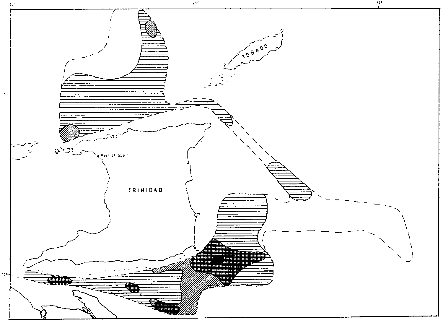
The distribution based on the data from the acoustic system is shown in Figure 3.4.2. In survey 1 during the passage along the north coast some fish concentration were located inshore off Trinidad identified as anchovies and sardines with some carangids and barracudas and off the northwest coast of Tobago where anchovies were caught together with some Spanish mackerels and barracudas. The wide offshore parts of the shelf was better covered in survey 2, but only very scattered recordings were made at that time both inshore and offshore. The repeated coverage in survey 4 again showed only very low levels of fish densities over the offshore parts of the shelf, but some aggregations were located within about 20 nm off the Trinidad coast and inshore northwest of Tobago. These were mostly small schools of clupeids and carangids with some barracudas. That the small pelagic fish in this area has a distribution mainly restricted to the nearshore shelf is probably a consistent phenomenon related to the up-welling system which causes enhanced primary production in the coastal belt. Here, as off the coast of Venezuela further west, a relationship can be shown between fish distribution and surface temperature where observations demonstrate declining values towards the shore.
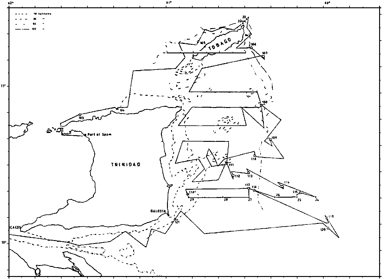
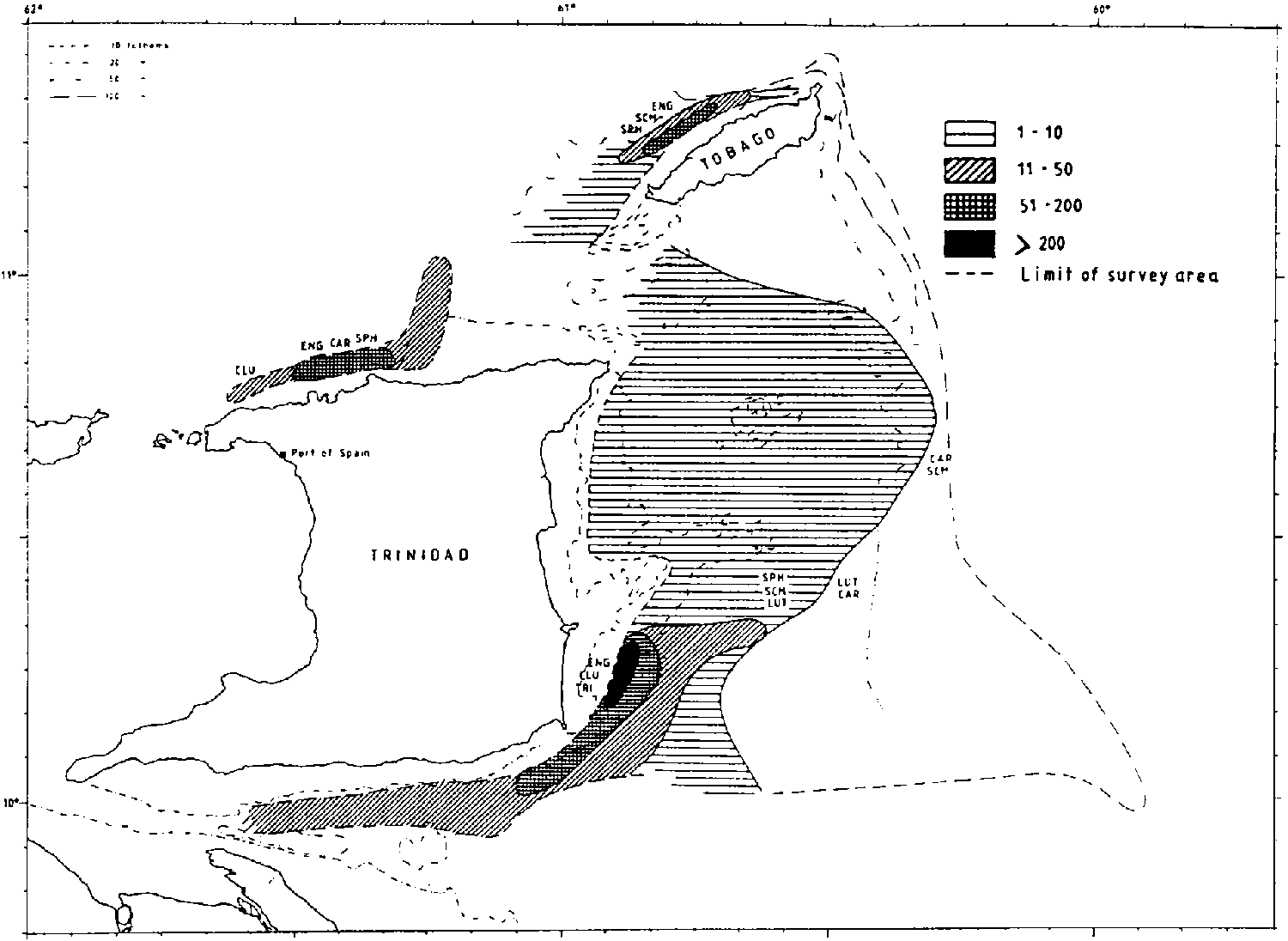
Figure 3.4.1. Trinidad and Common Fishing Zone. Course tracks and fishing stations, by surveys.
Figure 3.4.2a. Trinidad and Common Fishing Zone. Fish distribution as registered by the acoustic system, by surveys
Catch compositions
Table 3.4.1 shows a summary of catch data for the fishing experiments in this area. Because of differences in catchability as discussed in chapter 2, the catch rates do not necessarily show the true proportions between the different types and sizes of fish. Carangids are the most common group in the catches, together with clupeids. In May, also sharks contributed significantly to the catch.
Table 3.4.1 Trinidad, north coast. Pelagic fish. Catch rates in kg/hour by main groups by surveys. Mean rate, three highest rates and rate of occurrence.
|
|
Mean rate |
Highest rates |
Rate of occurrence |
|||
|
|
ENGRAULIDS |
|
|
|
|
|
|
4 November |
9 |
82, |
23, |
12 |
4/15 |
|
|
|
CLUPEIDS |
|
|
|
|
|
|
2 May |
116 |
575, |
3, |
2 |
3/5 |
|
|
4 November |
56 |
361, |
228, |
48 |
12/15 |
|
|
|
CARANGIDS |
|
|
|
|
|
|
2 May |
305 |
798, |
450, |
269 |
4/5 |
|
|
4 November |
108 |
559, |
237, |
163 |
15/15 |
|
|
|
BARRACUDAS |
|
|
|
|
|
|
2 May |
24 |
97, |
8, |
8 |
5/5 |
|
|
4 November |
14 |
66, |
62, |
32 |
10/15 |
|
|
|
HAIRTAILS |
|
|
|
|
|
|
2 May |
35 |
144, |
21, |
14 |
4/5 |
|
|
4 November |
34 |
195, |
136, |
61 |
13/15 |
|
|
|
SHARKS |
|
|
|
|
|
|
2 May |
117 |
217, |
207, |
134 |
4/5 |
|
|
4 November |
12 |
37, |
27, |
17 |
13/15 |
|
Table 3.4.2 Trinidad, north coast. Species distribution by families of small pelagic fish. Catch by weight of species by surveys as per cent of total catch of family.
|
Survey: |
2 |
4 |
Mean |
|
|
|
CLUPEIDS |
|
|
|
|
Mean catch, kg/hour |
116 |
56 |
|
|
|
Opisthonema oglinum |
1 |
11 |
6 |
|
|
Sardinella aurita |
1 |
1 |
1 |
|
|
Pellona harroweri |
|
30 |
15 |
|
|
Chirocentrodon bleekerianus |
99 |
41 |
70 |
|
|
Harengula jaguana |
|
14 |
7 |
|
|
|
||||
|
|
CARANGIDS |
|
|
|
|
Mean catch, kg/hour |
305 |
108 |
|
|
|
Chloroscombrus chrysurus |
|
11 |
6 |
|
|
Selene spp. |
77 |
71 |
74 |
|
|
Trachurus lathami |
9 |
10 |
10 |
|
|
Selar crumenophthalmus |
12 |
1 |
7 |
|
|
Trachinotus spp. |
3 |
4 |
3 |
|
Of the barracudas 2/3 of the total catch consisted of the guachanche species, the rest the southern sennet.
Of the sharks 82% of the catch were smooth-hounds with the smooth dogfish dominating, while 16% were sharpnose sharks mostly the Caribbean species.
Biomass estimates
The acoustic observations offish densities results in the following estimates of biomass:
|
Survey 1 |
16 000 |
tonnes |
|
Survey 2 |
11 000 |
tonnes |
|
Survey 4 |
18 000 |
tonnes |
Demersal fish
On the northern shelf the trawlable areas are restricted to the nearshore waters, extending 20-25 nm offshore. The survey input in this area has been limited to the second and fourth survey with respectively 5 and 15 random trawl stations. In the analysis below all the trawl stations are pooled, as the data is too limited to allow for analysis of seasonality. The biomass estimates are likewise restricted to the trawlable coastal zone.
The few mostly unsuccessful hauls attempted in the outer part of the shelf have not been included.
Fish distribution
The area is characterized by catches of croakers and snappers, a composition similar to that found off Orinoco and the south and east coasts of Trinidad.
The main species caught in the 0-50 m bottom depth zone were the whitemouth croaker Micropogonias furnieri, Jamaica weakfish Cynoscion jamaicensis, American harvest-fish Peprilus paru and southern red snapper Lutjanus purpureus. The 9 hauls in the 50-100 m bottom depth range were dominated by Jamaica weakfish, barbel drum Ctenosciaena gracilcirrhus, Atlantic bigeye Priacanthus arenatus and cardinal snapper Pristipomoides macrophthalmus.
Catch composition
Table 3.4.3 shows the mean catch rates in kg/hour and the catch distribution by size classes for the main commercial demersal species in the coastal zone off the Trinidad north coast. In Table 3.4.4 the mean catch rates have been summed by main groups. The croakers constitute the main groups both in the shallow and deeper parts, with 70 and 360 kg/hour respectively. This is followed by snappers with a respective catch of 13 and 38 kg/hour. The main commercial demersal Species sums up to about 80 and 400 kg/hour for two depth ranges, while the corresponding figures for other mostly non-commercial fish are 60 and 40 kg/hour. One should be aware of the possibility that both the catch rates and their difference by depth zone might reflect a seasonal feature and not yearly average conditions, as most of the survey input in this area was made in the fourth quarter.
Table 3.4.3 Trinidad north. Mean catch rates and catch distribution by size classes for all swept-area hauls carried out on the shelf.
|
Species |
Mean rate |
Number of hauls in catch groups *. |
Rate ofoccurrence* |
||||||
|
kg/hour |
1-30 kg |
30-100 kg |
0.1-03 t |
0.3-1 t |
1-3 t |
>3 t |
|||
|
0-50 m |
|
|
|
|
|
|
|
|
|
|
|
Whitemouth croaker |
30 |
6 |
4 |
1 |
|
|
|
11/23 |
|
Jamaica weakfish |
18 |
9 |
3 |
4 |
|
1 |
|
17/23 |
|
|
Americ. harvestfish |
18 |
11 |
2 |
1 |
|
|
|
14/23 |
|
|
Southern red snapper |
7 |
14 |
1 |
|
|
|
|
15/23 |
|
|
50-100 m |
|
|
|
|
|
|
|
|
|
|
|
Jamaica weakfish |
195 |
|
|
|
|
|
|
|
|
Barbel drum |
135 |
5 |
1 |
2 |
2 |
|
|
10/23 |
|
|
Atlantic bigeye |
9 |
6 |
1 |
1 |
|
|
|
8/23 |
|
|
Cardinal snapper |
15 |
9 |
3 |
1 |
|
|
|
13/23 |
|
* Calculated on basis all hauls total shelf.Table 3.4.4 Trinidad north. Mean catch rates (kg/hour) in all hauls by main commercial groups.
|
Family |
0-50 m |
50-100 m |
|
Snappers |
13 |
38 |
|
Groupers |
0 |
2 |
|
Croakers |
70 |
360 |
|
Grunts |
1 |
0 |
|
Other fish |
60 |
40 |
The area off the north coast suitable for trawling is about 450 nm2, with about equal shares in the 0-50 and beyond 50 m bottom depth zones. Annex 7 in the DATA FILES gives estimates of fish density by depth strata. By multiplying these densities with the given area of the shelf, estimates of standing biomass are obtained. These estimates are presented in Table 3.4.5.
The 0-50 m zone was estimated to hold 1 300 tonnes of fish, of which 750 (58%) was croakers, 100 tonnes (8%) snappers and 450 (34%) other, mostly noncommercial fish. The deeper area was estimated to hold 3 400 tonnes of which 2800 (82%) was croakers, 300 (9%) was snappers and 300 (9%) other fish. Two of the catches beyond 50 m were exceptionally large, and might indicate an overestimate in mean expected catch rates and biomass estimates if these high catches are not representative. The estimates of standing biomass might also reflect a seasonal situation as most of the sampling was done in the fourth quarter.
Table 3.4.5 Trinidad north. Estimates of biomass of demersal fish on trawlable area of the shelf by main groups.
|
Group |
0 - 50 m |
50 - 100 m |
Total |
|
Snappers |
100 |
300 |
400 |
|
Croakers |
750 |
2 800 |
3 550 |
|
Other demersal |
450 |
300 |
750 |
|
|
|
|
|
|
Total |
1 300 |
3 400 |
4 700 |
This shelf was covered in all surveys, but with varying objectives. An overall objective was to cover the offshore parts of the shelf both with acoustics and trials with trawl and other fishing gear. The fishing experiments in this part of the bank could, however, not be made in an adequate manner because the bottom conditions to the north of the Manzanilla Bank are generally unsuitable for trawling and long lining as tried in survey 1 is not an entirely suitable survey gear for our vessel. A series of successful tests for shrimp in the deep slope were, however, made. The eastern shelf south of the Manzanilla Bank has more favourable bottom conditions and this part was covered although not very intensively in all of the surveys.
Small pelagic fish
Fish distribution
Figure 3.4.2 shows the area covered and the fish distribution for each of the surveys. Wherever the offshore banks were covered either a total absence of fish recordings or very low densities were observed. The August survey with a fairly good coverage of the east coast shelf showed very low levels of recordings. Areas with aggregations of pelagic fish in schools and other formations were found in the inshore part of the shelf south of the Manzanilla Bank in February and May. The fish was identified as anchovies and sardines with some predators. One should note that inshore off the east coast there is a fairly wide shallow part of the bank which could not be covered by the survey and the areas of fish aggregations could have extended into these grounds.
This picture of absence of recordings or low densities offshore and fish aggregations restricted to an inshore zone is similar to that observed off Venezuela-Orinoco. In this region: Orinoco Delta-Columbus Channel-east coast of Trinidad there seems to be a correspondence between the areas of the shelf in which aggregations of pelagic fish were located and the parts affected by the discharges of the Orinoco identified by the low surface salinities. The region is likely to hold a unit system of fish assemblages.
Catch compositions
Table 3.4.6 shows the catch data for all fishing stations combined. The mean rates were low, with carangids dominating the contribution to total catch. The species distribution is shown in Table 3.4.7. Anchoas dominate the engraulids, thread herring and pellona the clupeids, and bumper and lookdown the carangids.
Table 3.4.6 Trinidad, east coast. Pelagic fish. Catch rates in kg/hour by main groups by surveys. Mean rate, three highest rates and rate of occurrence.
|
Main group |
Mean rate |
Highest rates |
Rate of occurrence |
||
|
ENGRAULIDS |
31 |
767, |
292, |
104 |
5/38 |
|
CLUPEIDS |
19 |
104, |
98, |
94 |
22/38 |
|
CARANGIDS |
23 |
262, |
152, |
99 |
30/38 |
|
SCOMBRIDS |
4 |
38, |
17, |
15 |
12/38 |
|
SHARKS |
11 |
136, |
53, |
48 |
24/38 |
|
|
% |
Incidence |
|
|
|
ENGRAULIDS |
|
|
|
Anchoa spp. |
67 |
3/38 |
|
|
Anchoviella spp. |
25 |
3/38 |
|
|
Engraulis spp. |
8 |
3/38 |
|
|
|
CLUPEIDS |
|
|
|
Opisthonema oglinum |
38 |
11/38 |
|
|
Pellona harroweri |
20 |
8/38 |
|
|
Chirocentrodon bleekerianus |
17 |
9/38 |
|
|
Harengula jaguana |
11 |
3/38 |
|
|
Sardinella aurita |
14 |
3/38 |
|
|
|
CARANGIDS |
|
|
|
Chloroscombrus chrysurus |
53 |
17/38 |
|
|
Selene spp. |
18 |
12/38 |
|
|
Trachurus lathami |
17 |
3/38 |
|
|
Decapterus spp. |
6 |
3/38 |
|
|
Trachinotus spp. |
3 |
1/38 |
|
If the very low estimates from survey 3 are discarded as a low seasonal availability the totals for surveys 1, 2 and 4 ranging from 22 000 tonnes to 45 000 tonnes with a mean of 30 000 tonnes and group estimates of 16 000 tonnes anchovies and sardines and 14 000 tonnes carangids and pelagic predators.
Demersal fish
Major parts of the east coast shelf is not suitable for trawling. There are some trawlable areas in the shallow waters between Galeota Point and Manzanilla Bank, and in the more offshore waters south of the same bank. In the analysis below catch rates of main species are given from the successful hauls made.
As the trawlable areas and the estimated densities from these are not representative for the whole shelf, absolute biomass figures for the whole shelf will not be made. 3, 5, 6 and 11 random bottom trawl stations were carried out in the respective four surveys. The few stations in each survey do not allow for analysis by season, and all data are pooled.
Catch distribution
The main species caught, with the mean catch rate and catch distribution by size groups are given in Table 3.4.8. The dominating species by weight were in the 0-50 m bottom depth zone: smalleye stardrum Stellifer microps 44 kg/h, white corvina Bairdiella crysura 40 kg/h, whitemouth croaker Micropogonias furnieri 40 kg/h, grey stardrum Stellifer griseus 25 kg/h, lane snapper Lutjanus synagris 25 kg/h, catfish Arius spp. 23 kg/h, Jamaica weakfish Cynoscion jamaicensis 14 kg/h and mutton snapper L. analis 10 kg/h. In the deeper waters, 50-100 m, catches were lower and the main species was Jamaica weakfish, 11 kg/h with some mutton snapper, 6 kg/h and barbel drum, 5 kg/h.
Table 3.4.8 Trinidad east. Mean catch rates and catch distribution by size classes for all swept-area hauls carried out on the shelf.
|
Species
|
Mean rate |
Number of hauls in catch groups *. |
Rate of occurrence* |
||||||
|
kg/hour |
1-30 kg |
30-100 kg |
0.1-03 t |
0.3-1 t |
1-3 t |
>3 t |
|||
|
0-50 m |
|
|
|
|
|
|
|
|
|
|
|
Smalleye stardrum |
44 |
2 |
1 |
2 |
1 |
|
|
6/34 |
|
White corvina |
40 |
|
|
|
2 |
|
|
2/34 |
|
|
Whitemouth croaker |
40 |
1 |
3 |
4 |
|
|
|
8/34 |
|
|
Grey stardrum |
25 |
|
1 |
2 |
|
|
|
3/34 |
|
|
Lane snapper |
25 |
15 |
2 |
1 |
|
|
|
18/34 |
|
|
Catfish |
23 |
4 |
|
2 |
|
|
|
6/34 |
|
|
Jamaica weakfish |
14 |
6 |
4 |
1 |
|
|
|
11/34 |
|
|
Mutton snapper |
10 |
3 |
1 |
1 |
|
|
|
5/34 |
|
|
50-100 m |
|
|
|
|
|
|
|
|
|
|
|
Jamaica weakfish |
11 |
|
|
|
|
|
|
|
|
Mutton snapper |
6 |
|
|
|
|
|
|
|
|
* calculated on basis all hauls total shelf.Table 3.4.9 shows the mean catch rates grouped by main fish groups. A total mean catch of demersal fish of 290 kg/h consisted of 66% croakers, 14% snappers, 3% grunts and 17% other fish, mainly non-commercial. In the few hauls on the outer shelf the mean catch was only 84 kg/h, with 20% each of snappers and croakers and the remaining 60% of other fish.
Table 3.4.9 Trinidad east. Mean catch rates (kg/hour) in all hauls by main commercial groups.
|
Family |
0-50 m |
50-100 m |
|
Snappers |
41 |
17 |
|
Groupers |
0 |
0 |
|
Croakers |
190 |
17 |
|
Grunts |
9 |
0 |
|
Other fish |
50 |
50 |
As representative areas for the fish distribution are not available, absolute estimates will not be given. We will, however, provide estimates on densities, which will facilitate comparisons with other regions. Annex 7 of the DATA FILES gives estimates of densities by species and species groups. In the 0-50 m the estimated mean density of demersal fish was 9.9 t/nm2, of which 6.4 was croakers, 1.4 snappers, 0.3 grunts and 1.8 other fish. In the deeper waters the total density was 3.1 t/nm2, of which snappers and croakers had 0.6 each, grunts only 0.1 and remaining 1.8 was other fish, mainly noncommercial.
Deep water shrimp
In all surveys some test hauls with bottom trawl were made for deep sea shrimp on the slope which in the southern part extends 30-40 nm outside the edge of the shelf before 700-800 m is reached. The results of these fishing experiments are summarized in Table 3.4.10 showing total catch rates and by species for the forms judged to be of commercial interest. There were some minor bycatches of non-commercial species mostly Nematocarcinus and Glyphocrangon species. The most important species are scarlet shrimp Plesiopenaeus edwardsianus and royal red shrimp Pleoticus robustus, the latter caught together with other commercial sized species of Solenoceridae.
The mean catch rates are low, but there are a few higher individual catch rates which may indicate patchiness or seasonal aggregations. One should note the variation of depth ranges for some of these species.
Table 3.4.10 Trinidad, east coast. Tests for deep water shrimp, 20 hauls 190-800 m. Catch rates in kg/hour and main depth
|
|
Mean catch |
Highest |
Incidence |
Depth |
||
|
All commercial shrimp |
9 |
39, |
16, |
12 |
20/20 |
|
|
Plesiopenaeus edwards. |
2 |
6, |
5, |
5 |
11/20 |
600-700 |
|
Pleoticus robustus a.o |
3 |
27, |
8, |
7 |
11/20 |
300-500 |
|
Penaeopsis serrata |
3 |
13, |
12, |
8 |
11/20 |
300-500 |
|
Acanthephyra sp. |
.6 |
5, |
3, |
3 |
5/20 |
700-800 |
As shown by the cruise tracks and fishing stations in Figure 3.4.1 the Joint Fishing Zone was covered in surveys 2, 3 and 4 with highest effort in the last two surveys. This is the area which must be expected to be most directly affected by the Orinoco discharges. Thus during the November survey the whole of the Colombus Channel was covered by a surface layer of low salinity water for which the depth limit at about 10 m was discernable as a discontinuity layer in the echo-diagrammes.
Small pelagic fish
Distribution
Figure 3.4.2 indicate that displacements of larger school areas may take place during the year within the Colombus Channel-east coast shelf. In the Joint Fishing Zone the highest densities were found in the November survey when fish aggregations in schools and layers were found over wide areas. Some of these seemed to extend into shallow inshore parts which could not be covered by the vessel. Trawl sampling and the characteristics of the echo traces showed that this was mostly small sized, partly juvenile stages of clupeids and anchovies mixed with small amounts of predators.
Catch composition
Table 3.4.11 shows the catch data by surveys. For nearly all groups the rates are lowest in August, as already found in the Guianas. Clupeids and hairtails were the most common forms, but carangids and scombrids gave occasional relatively high catches. As shown in Table 3.4.12. Anchovies dominated among the engraulids, dogtooth herring and pellona the sardines and bumper and lookdown the carangids.
Table 3.4.11 Joint Fishing Zone. Pelagic fish. Catch rates in kg/hour by main groups by surveys. Mean rate, three highest rates and rate of occurrence.
|
Survey |
Mean rate |
Highest rates |
Rate of occurrence |
|||
|
|
ENGRAULIDS |
|
|
|
|
|
|
2 May |
39 |
402, |
113, |
14 |
9/17 |
|
|
3 August |
3 |
28, |
23, |
5 |
5/24 |
|
|
4 November |
38 |
211, |
140, |
128 |
21/25 |
|
|
|
CLUPEIDS |
|
|
|
|
|
|
2 May |
99 |
1354, |
87, |
60 |
12/17 |
|
|
3 August |
26 |
105, |
102, |
87 |
18/24 |
|
|
4 November |
62 |
324, |
180, |
118 |
23/25 |
|
|
|
CARANGIDS |
|
|
|
|
|
|
2 May |
38 |
377, |
205, |
30 |
9/17 |
|
|
3 August |
5 |
29, |
24, |
16 |
11/24 |
|
|
4 November |
6 |
30, |
28, |
20 |
17/25 |
|
|
|
SCOMBRIDS |
|
|
|
|
|
|
2 May |
35 |
465, |
97, |
20 |
5/17 |
|
|
3 August |
1 |
91, |
8, |
7 |
3/24 |
|
|
4 November |
5 |
94, |
16, |
12 |
8/25 |
|
|
|
HAIRTAILS |
|
|
|
|
|
|
2 May |
89 |
754, |
262, |
197 |
15/17 |
|
|
3 August |
30 |
102, |
93, |
75 |
20/24 |
|
|
4 November |
33 |
119, |
103, |
102 |
25/25 |
|
|
|
SHARKS |
|
|
|
|
|
|
2 May |
17 |
100, |
92, |
41 |
10/17 |
|
|
3 August |
10 |
30, |
30, |
28 |
14/24 |
|
|
4 November |
4 |
33, |
15, |
13 |
17/26 |
|
|
|
SHRIMP |
|
|
|
|
|
|
2 May |
4 |
36, |
7, |
6 |
9/17 |
|
|
3 August |
7 |
20, |
16, |
16 |
18/24 |
|
|
4 November |
23 |
67, |
40, |
31 |
19/25 |
|
|
Survey: |
1 |
2 |
3 |
4 |
Mean |
|
|
|
ENGRAULIDS |
|
|
|
|
|
|
Mean catch, kg/hour |
|
39 |
3 |
38 |
|
|
|
Anchoa spp. |
|
93 |
100 |
29 |
74 |
|
|
Anchoviella spp. |
|
5 |
|
66 |
24 |
|
|
Engraulis spp. |
|
|
|
1 |
|
|
|
Lycengraulis spp. |
|
|
|
2 |
|
|
|
|
||||||
|
|
CLUPEIDS |
|
|
|
|
|
|
Mean catch, kg/hour |
|
99 |
26 |
62 |
|
|
|
Opisthonema oglinum |
|
5 |
|
11 |
5 |
|
|
Sardinella aurita |
|
5 |
|
3 |
3 |
|
|
Pellona harroweri |
|
17 |
16 |
27 |
20 |
|
|
Chirocentrodon bleekerianus |
|
71 |
80 |
48 |
66 |
|
|
Harengula jaguana |
|
1 |
4 |
11 |
5 |
|
|
|
||||||
|
|
CARANGIDS |
|
|
|
|
|
|
Mean catch, kg/hour |
|
38 |
5 |
6 |
|
|
|
Chloroscombrus chrysurus |
|
68 |
|
2 |
24 |
|
|
Selene spp. |
|
25 |
19 |
44 |
29 |
|
|
Hemicaranx amblyrhyncus |
|
1 |
13 |
|
5 |
|
|
Trachinotus spp. |
|
4 |
44 |
5 |
18 |
|
|
Oligoplites spp. |
|
2 |
11 |
33 |
15 |
|
|
Caranx hippos |
|
|
|
14 |
4 |
|
Table 3.4.13 Joint Fishing Zone. Sharks. Proportion by weight in catch, range of sizes and percentage occurrence in all catches.
|
|
|
Catch |
Range of size, kg. |
Incidence |
|
Requiem sharks, |
Carcharhinus spp. |
4 |
1 - 2 |
1 - 3 |
|
Sharpnose sh., |
Rhizoprionodon spp. |
21 |
0.6 - 1.3 |
15 - 22 |
|
Hammerheads, |
Sphyrna spp. |
18 |
1 - 10 |
6 |
|
Smooth-hounds, |
Mustelus spp. |
57 |
0.4 - 0.8 |
39 |
The acoustic observations offish densities provide the following biomass estimates:
|
|
Anchov. & sardines |
Carangids etc. |
|
Survey 2 |
12 000 tonnes |
18 000 tonnes |
|
Survey 3 |
10 000 tonnes |
|
|
Survey 4 |
35 000 tonnes |
5 000 tonnes |
Demersal fish
A special trawl survey of this area was an objective of the second survey, and the programme was repeated during the two succeeding surveys. At several locations parallel day and night hauls were made for comparison. In this analysis only the day hauls have been included as is normal for trawl surveys. 16, 18 and 15 successful day hauls were made during the three surveys respectively.
Catch distribution
The main demersal species with their yearly mean catch and with their catch distribution by size classes are shown in Table 3.4.14. The species were Jamaica weakfish Cynoscion jamaicensis, 49% of commercial demersal catch, whitemouth croaker Micropogonias furnieri, 19%, barbel drum Ctenosciaena gracilcirrus, 12%, king weak-fish Macrodon ancylodon, 12% and lane snapper L. synagris, 8%. The mean catch by main species groups are presented in Table 3.4.15. The croakers are the dominating group with about 135 kg/hour mean catch, followed by snappers with about 10 kg/hour. The grunts amount to only 2 kg/hour, while other demersal fish, mainly non-commercial, represent 45 kg/hour.
Table 3.4.14 Joint Fishing Zone. Mean catch rates and catch distribution by size classes for all day-time swept-area hauls carried out.
|
Species |
Mean rate |
Number of hauls in catch groups. |
Rate of occurrence |
|||||
|
kg/hour |
1-30 kg |
30-100 kg |
0.1-03 t |
0.3-1 t |
1-3 t |
>3 t |
||
|
Jamaica weakfish |
64 |
14 |
3 |
9 |
2 |
|
|
28/49 |
|
Whitemouth croaker |
25 |
26 |
10 |
2 |
|
|
|
38/49 |
|
Barbel drum |
16 |
17 |
7 |
2 |
1 |
|
|
27/49 |
|
King weakfish |
16 |
11 |
4 |
|
1 |
|
|
16/49 |
|
Lane snapper |
10 |
24 |
4 |
|
|
|
|
28/49 |
|
Family |
|
|
Snappers |
11 |
|
Groupers |
5 |
|
Croakers |
135 |
|
Grunts |
2 |
|
Other demersal |
45 |
The complete tables for analysis of biomass densities by species or species groups are available in Annex 7 of the DATA FILES. These densities are multiplied with the area of the shelf to obtain estimates of standing biomass. For the Joint Fishing Zone the area is calculated to 1210 nm. A considerable part of this is shallow inshore water where no sampling could be made.
The resulting biomass estimates by main species groups and surveys are presented in Table 3.4.16. Some variation in the estimates occurs between the surveys. This could well be sampling variance and not necessarily the effects of seasonal variation. The pooled estimate from all surveys represents an annual average, which is less influenced by the sampling variance. The croakers are estimated to 5 500 tonnes, snappers 450 tonnes, groupers 200 tonnes and grunts only 100 tonnes. Other demersal species, mostly of lesser economic importance represent a biomass of 2 000 tonnes. The total standing stock of demersal species is thus 8 200 tonnes with a mean density of 6.75 tonnes/nm.
Table 3.4.16 Joint Fishing Zone. Estimates of biomass of demersal fish by main groups and surveys.
|
|
Survey 2 |
Survey 3 |
Survey 4 |
Three surveys pooled |
|
Snappers |
800 |
250 |
300 |
450 |
|
Croakers |
6 000 |
4 700 |
5 000 |
5 500 |
|
Groupers |
0 |
500 |
0 |
200 |
|
Grunts |
250 |
0 |
0 |
100 |
|
Other demersal |
2 400 |
1 300 |
2 000 |
2 000 |
|
Total |
10 150 |
6 750 |
7 300 |
8 200 |
The survey data on shallow water shrimp from the three coverages of the Joint Fishing Zone are somewhat more comprehensive than those obtained further east in the Guianas. For the reasons discussed under Suriname above it was still found appropriate to base the analysis on the hauls only, in which the shrimp species appeared. Table 3.4.17 shows these catch data.
Table 3.4.17 Joint Fishing Zone. Shallow water shrimps. Mean catch rates in hauls where present and highest rates by surveys, mean rates for all surveys and by day/night, kg/hour. Total catch adjusted to a standard survey effort for all surveys.
|
|
Brown |
Red spotted |
White |
Pink |
|||
|
2 May |
7 |
(26) |
3 |
(25) |
1 |
2 |
(5) |
|
3 August |
6 |
(14) |
3 |
(8) |
1 |
3 |
(8) |
|
4 November |
14 |
(58) |
3 |
(9) |
5 |
7 |
(40) |
|
All surveys |
7 |
|
3 |
|
2 |
4 |
|
|
All surveys day |
8.9 |
|
2.2 |
|
3.2 |
5.8 |
|
|
All surveys night |
4.6 |
|
3.6 |
|
1.2 |
2.6 |
|
|
Adjusted catch |
287 kg |
|
219 kg |
|
|
226 kg |
|
Day and night test fishing
Some hauls were made with bottom trawl in the same locations during day and night to compare catch rates for the various groups. The station numbers and the positions of these hauls are shown in Figure 3.4.1 and Table 3.4.18 shows the results. A comparison limited to the mean rates shows that with the exception of some tests for shrimp all groups showed higher catch rates during daylight hauls than at night. The difference was highest for pelagic fish where it was of an order of 5-10 rimes. For demersal fish as a group the difference ranged from 1.1 to 1.7. A more detailed analysis should be made of the results from the comparative test fishing.
The resource description for this part will be somewhat inadequate due to an uneven coverage of the various parts of the shelf. The best sampling is from the Joint Fishing Zone, but even here the data are incomplete because of the relatively large very shallow areas which could not be covered by the survey. Still the main features of the distribution of the resources are probably reflected in the data and the estimates of standing stocks can be used for comparison with other sources of information. The aggregation of small pelagic fish to the inshore parts of the shelf and the low densities offshore is probably a true picture of the distribution of these resources. Rough bottom prevented an adequate coverage of the outer shelf by the trawl survey for demersal fish, but the few hauls made are indicative of low densities in these areas also for this resource category. It would also seem reasonable to expect that the highest densities of demersal fish should in general be related to those of the small pelagics on which they must depend as an important prey.
Table 3.4.18. Joint Fishing Zone. Standardized catch rates by main groups for day- and night hauls in the same positions, surveys 2, 3 and 4. Kgs/hour.
|
DAY |
SURVEY 2 |
|
ST.NO. |
DEP. |
Pelagic |
Demersal |
Shark |
Shrimp |
Squid |
Other |
|
433 |
50 |
82.0 |
171.6 |
1.8 |
6.0 |
|
5.6 |
|
434 |
44 |
2454.4 |
184.8 |
41.0 |
|
|
46.4 |
|
435 |
30 |
1242.0 |
698.0 |
50.4 |
|
|
353.6 |
|
438 |
22 |
337.4 |
29.9 |
2.0 |
0.7 |
|
22.2 |
|
439 |
20 |
267.2 |
172.8 |
|
0.6 |
|
73.8 |
|
MEAN |
|
876.6 |
251.4 |
19.0 |
1.5 |
|
100.3 |
|
NIGHT |
|
ST.NO. |
DEP. |
Pelagic |
Demersal |
Shark |
Shrimp |
Squid |
Other |
|
441 |
22 |
81.6 |
119.8 |
|
25.0 |
|
92.7 |
|
442 |
27 |
48.7 |
79.1 |
4.0 |
0.6 |
|
55.8 |
|
443 |
36 |
70.4 |
259.2 |
|
0.8 |
|
145.6 |
|
444 |
45 |
105.6 |
308.0 |
32.0 |
1.6 |
|
65.6 |
|
445 |
52 |
17.5 |
238.0 |
7.5 |
4.2 |
|
51.0 |
|
MEAN |
|
64.8 |
200.8 |
8.7 |
6.4 |
|
82.1 |
|
DAY |
SURVEY 3 |
|
ST.NO. |
DEP. |
Pelagic |
Demersal |
Shark |
Shrimp |
Squid |
Other |
|
705 |
37 |
133.0 |
204.8 |
20.0 |
5.0 |
4.2 |
53.2 |
|
707 |
27 |
210.4 |
255.2 |
|
3.2 |
3.2 |
80.0 |
|
708 |
24 |
146.8 |
336.0 |
|
|
4.0 |
113.6 |
|
716 |
40 |
85. 9 |
32.5 |
6.0 |
|
4.4 |
30.0 |
|
719 |
46 |
48.0 |
226.0 |
7.0 |
2.2 |
5.0 |
5.0 |
|
720 |
46 |
79.6 |
197.6 |
27.8 |
0.8 |
|
2.6 |
|
MEAN |
|
117.3 |
208.7 |
10.1 |
1.9 |
3.5 |
47.4 |
|
NIGHT |
|
ST.NO. |
DEP. |
Pelagic |
Demersal |
Shark |
Shrimp |
Squid |
Other |
|
722 |
31 |
5.6 |
205.0 |
12.4 |
6.6 |
|
27.8 |
|
723 |
32 |
10.8 |
76.8 |
|
7.2 |
|
23.6 |
|
724 |
33 |
5.8 |
74.0 |
|
7.0 |
|
43.6 |
|
727 |
44 |
|
7.0 |
|
|
|
1.4 |
|
728 |
45 |
8.4 |
146.4 |
5.2 |
4.0 |
|
19.2 |
|
729 |
36 |
60.0 |
248.6 |
|
20.0 |
|
84.0 |
|
MEAN |
|
15.1 |
126.3 |
2.9 |
7.5 |
|
33.3 |
|
DAY |
SURVEY 4 |
|
ST.NO. |
DEP. |
Pelagic |
Demersal |
Shark |
Shrimp |
Squid |
Other |
|
1054 |
17 |
431.0 |
50.0 |
5.2 |
6.3 |
|
23.6 |
|
1055 |
43 |
110.9 |
74.6 |
4.8 |
0.2 |
|
41.0 |
|
1058 |
17 |
273.7 |
63.1 |
12.3 |
|
|
83.1 |
|
1059 |
32 |
238.6 |
54.4 |
14.8 |
|
|
73.2 |
|
1060 |
31 |
69.8 |
58.2 |
2.5 |
29.8 |
12.0 |
42.7 |
|
1067 |
37 |
128.4 |
47.5 |
13.0 |
|
0.1 |
40.7 |
|
1068 |
53 |
91.3 |
88.2 |
1.2 |
4.8 |
1.2 |
39.8 |
|
1069 |
40 |
105.6 |
187.5 |
1.1 |
67.2 |
1.2 |
18.3 |
|
MEAN |
|
181.1 |
77.9 |
6.8 |
13.5 |
1.8 |
45.3 |
|
NIGHT |
|
ST.NO. |
DEP. |
Pelagic |
Demersal |
Shark |
Shrimp |
Squid |
Other |
|
1052 |
36 |
6.4 |
77.7 |
1.4 |
15.7 |
|
108.4 |
|
1053 |
49 |
21.9 |
102.5 |
11.0 |
4.5 |
|
8.4 |
|
1062 |
19 |
201.4 |
56.3 |
|
14.4 |
|
84.3 |
|
1064 |
45 |
9.8 |
62.4 |
6.3 |
1.2 |
|
12.0 |
|
1065 |
19 |
33.7 |
52.3 |
1.8 |
21.4 |
|
33.1 |
|
1070 |
33 |
29.5 |
95.6 |
|
15.6 |
|
10.6 |
|
1071 |
29 |
32.0 |
47.9 |
|
9.7 |
|
84.7 |
|
MEAN |
|
47.8 |
70.7 |
2.9 |
11.8 |
|
48.8 |
Table 3.4.19 Trinidad and including Joint Fishing Zone. Overview of estimates of biomasses by main groups. Tonnes.
|
|
N. coast |
E. coast |
J.F.Z. |
Total |
|
|
Pelagic fish |
|
|
|
|
|
|
|
Anch. & sard. |
6 000 |
16 000 |
24 000 |
46 000 |
|
Carang. etc. |
12 000 |
14 000 |
12 000 |
38 000 |
|
|
Total |
|
|
|
84 000 |
|
|
Demersal fish |
|
|
|
|
|
|
|
Croakers |
3 600 |
* |
5 500 |
9 100 |
|
Snappers |
400 |
* |
450 |
850 |
|
|
Groupers |
|
* |
200 |
200 |
|
|
Grunts |
|
* |
100 |
100 |
|
|
Others |
750 |
* |
2 000 |
2 750 |
|
|
Total |
|
|
|
13 000 |
|
|
Sharks |
600 |
* |
500 |
1 100 |
|
|
Total |
|
|
|
98 000 |
|
* No estimate available.The official landing statistics with a total reported catch of about 3 000 tonnes indicate a low or moderate level of fishing for most of the resource groups covered by the survey, perhaps with the exception of Spanish mackerels where the annual catch of about 1 200 tonnes may represent a significant level of exploitation. These stocks have, however, probably a wide distribution and the Trinidad fishery may draw on stocks offshore and in neighbouring areas. Assuming a long term yield of 20% of the biomass of long lived moderately exploited stocks would give 2 000 tonnes of demersal fish, mainly croakers. There would be 1 000-2 000 tonnes of hairtails and barracudas and a similar amount of larger carangids. In addition one can at least in theory calculate a potential yield from the small anchovies, sardines and carangids of perhaps 20 000 tonnes. *
![]()
![]()
![]()