AQUASTAT - 粮农组织全球水与农业信息系统
papers
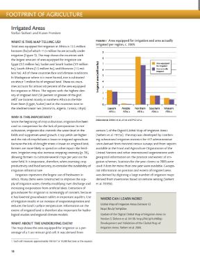
Irrigated areas - Atlas of African agriculture research & development
e-Atlas and Book (published by IFPRI) 2014
This chapter on "Irrigated areas" of the Atlas of African agriculture research & development describes irrigation areas in Africa, shows them on a map and explains the underlying data. The atlas is part of a wide-ranging eAtlas initiative that showcases, through print and online resources, a variety of spatial data and tools generated and maintained by a community of research scientists, development analysts, and practitioners working in and for Africa.
Groundwater use for irrigation - a global inventory
Paper (published by Hydrology and Earth System Sciences (HESS) Journal) 2010
While the extent of irrigation and related water uses are reported in statistical databases or estimated by model simulations, information on the source of irrigation water is scarce and very scattered. This new global inventory presents the extent of areas irrigated with groundwater, surface water or non-conventional sources of water, as well as the related consumptive water uses. The inventory provides data for 15 038 national and sub-national administrative units. Irrigated area was provided by census-based statistics from international and national organizations. A global model was then applied to simulate consumptive water uses for irrigation by source of water.
The resource outlook to 2050: By how much do land, water and crop yields need to increase by 2050?
Expert Paper for FAO World Summit on Food Security 2009
This paper discusses the natural resource implications of the latest FAO food and agriculture baseline projections to 2050 “World agriculture: towards 2030/2050“. These projections offer a comprehensive (food and feed demand, including all foreseeable diet changes, trade and production) and consistent picture of the food and agricultural situation in 2030 and 2050. The main purpose of this paper is to provide an indication of the additional demands on natural resources derived from the crop production levels in 2030 and 2050 as foreseen in the FAO 2006 projections.
Trends in water and agricultural development. Chapter 2 of the book: Water for food, water for life
Paper (published by Earthscan, London, and IWMI, Colombo) 2007
This assessment describes key water-food-environment trends that influence our lives today and uses scenarios to explore the consequences of a range of potential investments. It aims to inform investors and policy-makers about water and food choices in light of such crucial influences as poverty, ecosystems, governance, and productivity. It covers rainfed agriculture, irrigation, groundwater, marginal-quality water, fisheries, livestock, rice, land, and river basins.
Dams and agriculture in Africa
This paper gives an overview of dams in Africa, their main purpose, and future prospects. The inventory includes almost 1 300 large and medium-size dams, 40 percent of which are located in South Africa. The majority of dams has been constructed to facilitate irrigation (52 percent) and to supply water to municipalities (20 percent). Almost 20 percent of dams have multiple purposes, of which irrigation is almost always one of the purposes. Although only 6 percent of dams were built primarily for electricity generation, hydroelectric power accounts for more than 80 percent of total power generation in 18 African countries and for more than 50 percent in 25 countries.
Key water resources statistics in AQUASTAT
This article describes the methodology used by AQUASTAT to assess natural and actual freshwater resources for the world by country. It deals with renewable water resources and concentrates mainly on the physical assessment of internal and external resources. It presents a picture of the state of the world’s water resources that is not only the natural state but also the current situation, taking into account existing uses of water and their implications for countries sharing river basins. Much remains to be done in order to obtain sound statistics on water resources, and particularly standardized data sets, at global level. This article presents some reflections in this sense.
Development and validation of the global map of irrigation areas
Paper (published by Hydrology and Earth System Sciences (HESS) Journal) 2005
A new version of a digital global map of irrigation areas was developed by combining irrigation statistics for 10 825 sub-national statistical units and geo-spatial information on the location and extent of irrigation schemes. The map shows the percentage of each 5 arc minute by 5 arc minute cell that was equipped for irrigation around the year 2000. This paper describes the data set and the mapping methodology and gives, for the first time, an estimate of the map quality at the scale of countries, world regions and the globe. Two indicators of map quality were developed for this purpose, and the map was compared to irrigated areas as derived from two remote sensing based global land cover inventories.
AQUASTAT - Getting to grips with water information for agriculture
This document was prepared for the Sixth Water Information Summit, Delft (WIS6), The Netherlands, 9-12 September 2003. It describes the AQUASTAT information system, which consists mainly of: a) systematic descriptions of the state of agricultural water management by country; b) up-to-date online data by country; c) digital geographical data on water resources and irrigation; d) specific thematic studies. Its experience indicates the importance of systematic data and information collection and evaluation, harmonized definitions and classifications, associated metadata, support for evaluation in the database management system, website properties to guarantee quick and good access for all users, and collaboration with other institutes.
The FAO irrigated area forecast for 2030
Agriculture accounts for about 70 percent of the freshwater withdrawals in the world and is usually seen as the main factor behind the increasing global scarcity of freshwater. In the framework of “World Agriculture: Towards 2015/2030”, FAO reviewed the current status and role of irrigation in 93 developing countries, and assessed the likely situation of irrigation in 2015 and 2030. The method used in this assessment and the main results of the study, in terms of agricultural production, land under irrigation and agricultural water use are presented in this paper.
Hydro-agricultural development in Africa - Current situation and prospects
Unpublished paper 1999 (french)
In order to better understand the challenges Africa is facing related to irrigation, an overview of the water management situation in the continent is presented in this article. First a description of the present situation of irrigation in Africa is given. Then the irrigation is placed in the broader context of agricultural production and food security, with a special emphasis on Western Africa. Finally prospects for water management in Africa during the next decades are given.
Assessment of irrigation potential in Africa
This article is based on the study “Irrigation potential of Africa: a basin approach”. To integrate information on land and water at the river basin level, knowledge of irrigation water requirements per unit of land area is necessary. Arc-Info was used to define the geographical computation units, which are homogeneous regarding average rainfall, potential evapotranspiration, cropping pattern (calendar, intensity) and irrigation efficiency. Combining information on gross irrigation water requirements, area of soils suitable for irrigation and available water resources by basin eventually results in an estimation of the physical irrigation potential for Africa.


