2. SITE SELECTION AND GENERAL PLANNING
2.0 The importance of a good site1. The whole future success of your enterprise depends on the selection of a good site for your fish farm. The layout and the management of your farm will largely be influenced by the kind of site you select. The site therefore will strongly affect the cost of construction, the ease with which the ponds can be managed, the amount of fish produced and, in general, the economics of your enterprise. |
 |
2.1 Preliminary decisions
1. Before starting to look for a site, you should have a clear idea of the type of fish farm you wish to build. Some of the questions you should ask yourself are the following.
(a) Which level of production do I plan to reach, subsistence or commercial?
Which scale, if commercial?
(b) Which culture system shall I adopt?
- extensive or intensive;
- one or several species;
- seasonal or year-round.
(c) Shall I use fertilizers or fish feeds or both?
(d) Which species of fish shall I produce and at which size shall I sell
them?
(e) Shall I have to buy juveniles or produce them all myself?
(f) Shall I try to integrate my fish farming activities with other agricultural
productions I already have? Shall I also start raising animals on my farm?
(g) Which area of the farm do I wish to develop immediately? Will I develop
other areas later, as a second phase?
2. If you cannot answer these questions by yourself, you should look for assistance, for example from the local extension agent specialized in fish farming. You can also check with other farmers to find out what choices they made and why.
HOW TO SELECT A SITE FOR FRESHWATER
FISH CULTURE
|
The decision-making cycle |

2.2 Major considerations
1. The major factors to be considered when selecting a site for the construction of a freshwater fish farm are water supply, soil quality and local topography. However, other factors also have some importance (see Section 2.3).
2. When you consider all the factors for selecting a site for a particular purpose, you may find that there are no suitable sites in your area. This can often happen; you then have to find out whether you can change your plans or ideas to meet the characteristics of the sites that are available. You may also be able to get assistance with this.
3. It is also important to remember that there is no point in carrying out a detailed survey or assessment of a site unless you are reasonably sure it meets the basic needs of the farming you plan to do.
Water supply and site selection
4. It is essential that you have the required supply of good quality water at the time needed to operate your fish farm. Preferably, it should be available all year round.
5. You have learned in a previous manual in this series
- how to estimate the quantity of water you will need to operate your fish farm (2 to 5 I/s/ha) (Water, 4, chapter 2);
- how to provide for such a water supply, if necessary from a small reservoir to be built on your farm (Water, 4, chapter 4).
Note: you should always give preference to a site where you will be able to obtain your water supply by gravity*. If you do have to pump, try to minimize the distance, particularly the height (head) at which you need to pump (see also Section 3.9).
|
Water supply
 |
 |
 |
 |
6. It is important that your water supply is of good quality. Try to get a supply which is reasonably clear of leaves, branches, plastic bags and other rubbish, as they can easily block your feeder canals or pond inlets. You should be particularly vigilant of the presence of chemical pollution. It may originate not only from certain industries but also from agricultural land where crops such as cotton, citrus and tomatoes are intensively produced. Pesticides can also be regularly applied to rice fields and to irrigation canals to control insects, snails and weeds.
|
Estimate quantity of water needed
|
Estimate water losses |
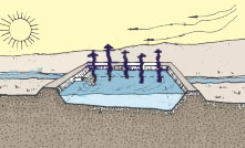
Evaporation losses |

7. Find out also, if you can, whether there are any developments being planned, such as setting up a new factory, a new crop or crop technology, ploughing, quarry or construction works, which could affect the water quality.
|
|

Soil quality and site selection
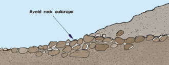
8. You have learned in a previous manual in this series (Soil, 6) all you should know about soil to be used for fish farming. Remember to:
- avoid sites with rock outcrops, gravel beds, sandstone and limestone;
- beware of sandy soils and termite mounds;
- give preference to soils such as sandy clay, silty clay loam and clayey loam.
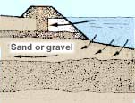
9. Remember that even a small layer of a troublesome material such as gravel, sand or acidic clay can cause problems. If there are such layers, make sure that the earthworks on the site do not enter into them.
 |
 |
|
Water losses
 |
No water losses
 |
Acidic clay may contaminate
the water  |
Local topography and site selection
10. Local topography largely determines which type of pond you will build (see Section 1.6). The choice is based on the study of the longitudinal profile and cross-sectional profiles of the valley. You have learned in a previous manual in this series (Sections 9.5 and 9.6, Topography) how to do these studies either from existing maps or from your own measurements.
11. Look for sites:
- where water drainage will be possible by gravity*;
- where the earthwork will be minimum;
- where it will be easy to balance the volume of earth to be excavated and that to be filled in.
12. You will find such sites on gently sloping ground, where the slope is 0.5 to 3 percent. Avoid slopes greater than 5 percent. If you have to use horizontal land, it will be more costly to build drainable ponds.
|
Selecting a site
 |
 |
13. You will also have to ensure that the size of the selected site is large enough for your immediate purpose and, if necessary, for future expansion. A regular shape will make it easier to plan.
14. If you select a low-lying site, at the bottom of a valley for example, you should ascertain that the pond area will be free f
om deep flooding. Carefully observe the marks left by flood waters on bushes, trees, bridges, rocks or other permanent structures. Ask local people and specialized authorities, if necessary, to inform you about the expected depths of floods, in particular exceptional floods.
 |
2.3 Other important characteristics of the site
1. There are other site characteristics which are also important to consider during selection.
(a) Vegetation cover: if there are big trees
or a dense population of smaller trees, clearing
the land will be difficult and costly (see Section 5.2). Open woodland,
grassland, old paddy fields or land covered with low shrubs permit easier
and cheaper construction.
(b) Accessibility: the use of artificial feeds
on a commercial farm, pond management and marketing will require good
access by road to the site. On the other hand, for subsistence ponds or
small-scale operations, access on foot or by bicycle or motorbike might
be sufficient.
(c) Proximity to your home: it is
always best to live close to your ponds. It will be easier to manage
them and to protect them against poaching. For larger farms, a place must
often be built for people who are looking after the ponds (see for example
Section 1.8).
(d) Multiple uses of the ponds: it is sometimes advantageous
to be able to use your ponds for purposes other than fish farming such
as livestock watering, gardening or domestic use. Such
integrated fish farming should be well planned (see Section 1.7, paragraphs
9 and 10).
(e) Proximity and size of market: once harvested, your fish
should preferably be sold fresh, as soon as possible and with the least
costs. You should know in advance how many fish you will be able to sell
in one day and plan your pond sizes and harvests accordingly.
(f) Availability of inputs: if your fish farm requires regular
inputs such as feed ingredients and juvenile fish, they should be available
locally. You might also want to hire casual labour to help you from time
to time. Spare parts and supplies might also be necessary.
Note: remember to ensure that there are no legal restrictions on the utilization of the site and the usage of water.
 |
2.4 How to locate and study potential sites quickly
1. Unless you know the region well, it will be difficult for you to locate quickly those sites whose features are likely to be favourable.
|
2. Your field surveys will be easier if you can make preliminary studies from existing topographical maps, at the 1:50 000 scale for example (see Section 11.1, Topography). From the types of valley in the region and their longitudinal profiles, you can already decide on the possible types of pond to be built (see Section 1.6). 3. If you decide on a barrage pond, you can estimate its drainage area and the water available through runoff*. 4. The availability of access roads can be determined. If roads exist but are too far away, the potential of the site might be limited by the cost of building an access road. 5. If available, other kinds of maps, such as soil maps and hydrological maps, can also be very useful. |
TOPOGRAPHICAL MAP
 |
Note: an example of a topographical map at the scale 1:50 000 is shown above. Below, this map is greatly enlarged to help Illustrate how to use it. Note that various kinds of terrain are labelled as well as the location of a number of possible pond sites (see site A, B, C, D, E and F).
 |
2.5 How to evaluate a potential site
1. Each potential site should be evaluated in the field through a series of quick reconnaissance surveys to ensure that the major requisites are met:
- availability of water supply (see Water, 4);
- quality of water supply (see Chapter 2, Management);
- adequacy of soil quality (see Section 2.4, Soil, 6);
- suitability of topography (see Topography, 16).
2. How thorough you need to be with each of these surveys will depend on the size of the fish farm you plan to build.
| 3. For a small fish farm with an area less than 3 000 m2 , a small series of rough measurements will be sufficient. |
Check water supply |
|
| 4. For a larger fish farm where layout and gradients are critical, you will need more accurate measurements. |
 |
|
|
Check soil quality
 |
 |

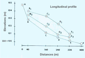
5. The purpose of the reconnaissance topographical survey
is to check if ponds can be built both from the technical and economic
points of view.
(a) A longitudinal profile of the stream will give you the difference
in elevation between various points. It will tell you if ponds can be
built (see Section 1.8).
(b) A longitudinal profile of the site will confirm whether the site is
also suitable (i.e. generally sloping) and would match well with the stream
elevations.
|
Potential site
 |
Longitudinal profiles
 |
(c) Cross-section profiles of the site, perpendicular to the longitudinal profile, at 20- to 50-m intervals or less for small ponds and in irregular terrain, will give you the shape and size of the site.
|
Potential site
 |
Cross-section profile GBH
 |
6. From these measurements and other observations (see Sections 2.1 to 2.3), you should be able to make a first evaluation of the site. This evaluation should lead you either to reject or retain it as a potential site. In the latter case, you will need to study the site in more detail (see Section 2.6).
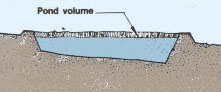
7. If you plan to use the site for a barrage pond, you could proceed immediately with the feasibility study of the site by estimating:
8. Then compare these last two values. If the volume of the pond is greater than ten to 15 times the volume of the dam, and if the longitudinal slope of the farm site is less than 2 to 3 percent, the topography of the site can be considered acceptable.
 |
|
9. However, when selecting a site for a barrage pond, remember that you should try to:
|
Wide valley with narrow end
 |
|
|
||
 |
 |
|
2.6 How to begin planning your fish farm construction
1. Now that you have selected the site of your fish farm, you should initiate the planning of the fish farm, which has two main related components:
- the organizational planning, in which you decide where, how and in which order you will build the farm (see Chapter 12);
- the physical planning, in which you decide on layouts, detailed design and earthwork.
2. Below is a general layout of a small fish farm chosen on the basis of soil and topographical surveys of the selected site.
3. The physical planning, which should be done in several steps, is discussed below from paragraph 7.
4. You will learn how to develop detailed plans and drawings for such a fish farm in Section 12.4).
|
Detail of the area of the selected site chosen
for a small fish farm (see section 2.3)
|


Detailed topographical survey of the site
5. Such a survey should enable you to prepare an accurate topographical plan of the site (see Chapter 9, Topography) and should include:
- scale from 1: 1 000 (small farm) to 1: 2 000 (larger farm);
- contours at a vertical interval of 0.20 - 0.50 m;
- existing structures (buildings, reservoir, power lines, etc.);
- access roads and tracks;
- water supply (springs, stream, canal);
- property boundaries, if close enough to site;
- particular features (rocks, pits, ant hills, trees);
- location of bench-marks and soil sampling stations.
Detailed soil survey of the site
6. Make a detailed soil survey of the site (see Section 2.5, Soil, 6) and show the results on the topographical plan.
Layout of the fish farm
7. On the basis of all the information now available to you, decide upon the type of pond (or ponds) it is best to build (see Section 1.6), and which layout to adopt (see Sections 1.7 and 1.8). To do this, it may be helpful to make one or more simple versions of the site plan, with the main features identified, on which you can sketch out in pencil alternative layouts.
8. When you have worked out a layout which suits your needs, you can use a copy of the topographical plan of the site to prepare a more detailed topographical plan of the fish farm showing the number of ponds, their size and orientation, the dikes, the water supply system, the drainage system and other structures as necessary. You will learn more about all these in the following chapters.
9. You will have to check your layout carefully to see that:
- you dig out about the same quantity of earth as you need to build up (see Chapter 6);
- water levels are correct in the site to allow the ponds to fill and drain.
10. If these two points do not work out properly, you may have to amend the layout and then recheck earth and water levels.
11. Once you are satisfied that earthwork volumes and water levels are reasonably good and that the layout is suitable, you can proceed with the more detailed planning.
12. Begin by learning more about materials, equipment, various structures commonly used on fish farms, their function and how to build them. These will be described in the following sections of this manual.
13. You will then be able to plan the construction of your fish farm properly in more detail and according to your own requirements. This will be described in the second part of this manual.