![]()
![]()
![]()
| THE NIGER-BENUE SYSTEM (Map 15) | SYSTEME NIGER-BENOUE (Carte 15) |
| Rivers | Fleuves |
| NIGER | NIGER |
| Source: Fouta Djallon, Guinea | Source: Fouta Djallon, Guinée |
| Altitude: 3 270 ft | Altitude: 1 000 m |
| Total length: 2 620 mi | Longueur totale: 4 183 km |
| Drainage area: 435 000 mi2 including the Benue | Bassin hydrographique: 1 125 000 km2 y compris la Benoué |
| Area of water: | Bankfull | Flooded | Superficie en eau: | Au niveau de débordement | Après inondation | |
| acres | acres | ha | ha | |||
| Dahomey | 7 900 | 60 000 | Dahomey | 3 200 | 24 300 | |
| Mali (central delta) | - | 4 200 000 | Mali (delta central) | - | 1 700 000 | |
| Niger | 66 500 | 156 000 | Niger | 27 000 | 63 000 | |
| Nigeria | 445 000 | 1 180 000 | Nigeria | 180 000 | 480 000 |
Countries traversed: Dahomey, Guinea, Ivory Coast, Mali, Niger, Nigeria, Upper Volta | Pays traversés: Dahomey, Guinée, Côte-d'Ivoire, Mali, Niger, Nigeria, Haute-Volta |
Major tributaries: Bani (Mali), Alibori, Mekrou, Sota (Dahomey), Benni (Upper Volta), Bagoue (Ivory Coast), Sokoto, Benue (Niger) | Principaux affluents: Bani (Mali), Alibori, Mekrou, Sota (Dahomey), Benni (Haute-Volta), Bagoue (Côte-d'Ivoire), Sokoto, Benoué (Niger) |
Discharges to: Atlantic Ocean | Se jette dans: l'Océan Atlantique |
| Volume of discharge at mouth: 21 500 ft3/sec. | Débit à l'embouchure: 6 100 m3/sec. |
| Suspended silt load: 5 050 000 t/year | Charge de vase en suspension: 5 050 000 t/an |
Flood regime: At Nigerian border there are two floods one with a peak in January-February originating from Guinea, the other in August-October originating locally. | Régime des crues: A la frontière nigérianne il y a deux crues, l'une atteignant un maximum en janvier-février et provenant de la Guinée, l'autre en août-octobre et d'origine locale. |
| Special features: Internal delta and lakes (Mali), Kainji dam and reservoir (Nigeria). Delta at mouth. | Caractéristiques particulières: Delta intérieur et lacs (Mali), barrage et lac artificiel de Kainji (Nigeria). Delta à l'embouchure. |
| Physical and chemical data: | Données physiques et chimiques: | |||
| Conductivity | Upper course | K20 31 μ mhos (DAGET, 1957) | Cours supérieur | Conductivité |
| Temperature | Upper course | 19–30°C (DAGET, 1957) | Cours supérieur | Température |
| pH | Upper course | 7.2 (DAGET, 1957) | Cours supérieur | pH |
| Middle course | 6.7–6.8 (FAO/UN, 1962) | Cours moyen | ||
| At level of central delta (DAGET, 1957) | Au delta central (DAGET, 1957) | |
Alkalinity N × 104 | 4 | Alcalinité N × 104 |
Na | 3 mg/l | Na |
Ca | 4 mg/l | Ca |
K | 1.9 mg/l | K |
Mg | - | Mg |
Cl | 1 mg/l | Cl |
SO4 | - | SO4 |
At level of Kainji dam (WHITE, 1965) | Au barrage de Kainji (WHITE, 1965) | |
Ca | 0.086–0.130 m M/l | Ca |
Mg | 0.049–0.112 m M/l | Mg |
Na | 0.098–0.252 m M/l | Na |
HCO3 | 0.404–0.634 m M/l | HCO3 |
SO4 | 0–0.018 m M/l | SO4 |
Cl | trace-0.036 m M/l | Cl |
NO3 | 1.43–6.29 μ M/l | NO3 |
PO4 | 0.161–1.034 μ M/l | PO4 |
| Total annual catch: | Captures annuelles totales: | ||||
| Dahomey | 1 000 | t (FAO/UN, 1971) | Dahomey | 1 000 | tonnes (FAO/NU, 1971) |
| Mali | 90 000 | t | Mali | 90 000 | tonnes |
| Niger | 9 696 | t (FAO/UN, 1971) | Niger | 9 696 | tonnes (FAO/NU, 1971) |
| Nigeria | 13 450 | t (FAO/UN, 1970) | Nigeria | 13 450 | tonnes (FAO/NU, 1970) |
| total | 114 146 | t | totales | 114 146 | tonnes |
| Number of fish species: 135 (DAGET, 1954) | Nombre d'espèces de poissons: 135 (DAGET, 1954) | ||||
| BENUE | BENOUE | ||||
| Source: Adamowa Mountains, Cameroon | Source: Massif de l'Adamoua, Cameroun | ||||
| Total length: 875 mi | Longueur totale: 1 400 km | ||||
| Area of water: | in Nigeria at | Superficie en eau: au Nigeria au | |||
| bankfull | 316 000 acres | niveau de dêbordement | 129 000 ha | ||
| flooded | 755 000 acres | après inondation | 310 000 ha | ||
| Countries traversed: Cameroon, Nigeria | Pays traversés: Cameroun, Nigeria | ||||
Major tributaries: Mayo-Kebbi (Cameroon) | Principaux affluents:
Mayo-Kebbi (Cameroun) | ||||
| Total annual catch: | Captures annuelles totales: | ||||
| Cameroon | 3 000 | t | Cameroun | 3 000 | tonnes |
| Nigeria | 9 570 | t (FAO/UN, 1970) | Nigeria | 9 570 | tonnes (FAO/NU, 1970) |
| total | 12 570 | t | totales | 12 570 | tonnes |
Number of fish species: 113 Mayo Kebbi (BLACHE, 1964); 128 Benue (STAUCH, 1966) | Nombre d'espèces de poissons: 113 Mayo Kebbi (BLACHE, 1964); 128 Benoué (STAUCH, 1966) | ||||
| SOKOTO | SOKOTO |
| Source: N. Nigeria near the town of Funtua | Source: Nord du Nigeria près de la ville de Funtua |
| Countries traversed: Niger (Rima River), Nigeria | Pays traversés: Niger (fleuve Rima), Nigeria |
| Major tributary: Rima | Principal affluent: Rima |
| Discharges to: Niger | Se jette dans: le Niger |
Flood regime: Floods extend from July to November. | Régime des crues: Les crues durent de juillet à novembre. |
| Special features: A floodplain 5 mi wide | Caractéristiques particulières: Plaine d'inondation de 8 km de large |
Physical and chemical data: after HOLDEN and GREEN, 1960 | Données physiques et chimiques: d'après HOLDEN et GREEN, 1960 |
| Temperature | 18–30°C | Température |
| pH | 6.9–8.1 | pH |
| Hardness CaCO3 | 27.5–103.0 | Dureté CaCO3 |
| Alkalinity CaCO3 | 42.5–127.5 | Alcalinité CaCO3 |
| NH4 | 0.04–0.12 ppm | NH4 |
| Mg | 2.0–10.0 ppm | Mg |
| Ca | 10.0–42.0 ppm | Ca |
| Fe total | 0.2–1.4 ppm | Fe total |
| Mn | < 0.025–0.075 ppm | Mn |
| Na | 3.1–11.0 ppm | Na |
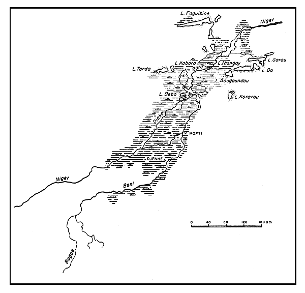
Map 16 Central delta of the Niger river
Carte 16 Delta central du fleuve Niger
| K | 2.8–13.2 ppm | K |
| F | 0.1–0.7 ppm | F |
| Cl | 1.0–15.0 ppm | Cl |
| NO2 | < 0.003–0.07 ppm | NO2 |
| NO3 | 0.11–0.44 ppm | NO3 |
| PO4 | 0.1–0.1 ppm | PO4 |
| HCO3 | 25.9–77.8 ppm | HCO3 |
| SiO2 | 10.0–20.0 ppm | SiO2 |
| Lakes | Lacs |
| LAKES OF THE CENTRAL DELTA (Map 16) | LACS DU DELTA CENTRAL (Carte 16) |
| A group of lakes situated on the floodplain of the central delta region in Mali at an altitude of about 855 ft. The level of the lakes rises and falls with the seasonal flooding of the Niger River. | Un groupe de lacs se trouve dans la plaine d'inondation de la région du delta central au Mali, à une altitude d'environ 262 m. Le niveau des lacs s'élève et s'abaisse selon les crues saisonnières du fleuve Niger. |
| Aougoundou | Aougoundou |
| Area: 31–50 mi2 | Superficie: 80–130 km2 |
| Do | Do |
| Area: 46.5 mi2 | Superficie: 120 km2 |
| Maximum length: 11 mi | Longueur maximum: 18 km |
| Maximum width: 11 mi | Largeur maximum: 18 km |
| Depth: 31 ft (max) | Profondeur: 9,5 m (max) |
| Faguibine | Faguibine |
| Area: 309 mi2 | Superficie: 800 km2 |
| Maximum length: 44 mi | Longueur maximum: 70 km |
| Maximum width: 62.5 mi | Largeur maximum: 100 km |
| Maximum depth: 32.7 ft | Profondeur maximum: 10 m |
| Gakore | Gakore |
| Area: 13.2 mi2 | Superficie: 34 km2 |
| Maximum depth: 14.4 ft | Profondeur maximum: 4,4 m |
| Volume: 5 300 × 106 ft3 | Volume: 150 × 106 m3 |
| Garou | Garou |
| Area: 23–46 mi2 | Superficie: 60–120 km2 |
| Maximum length: 19 mi | Longueur maximum: 30 km |
| Maximum width: 2.5 mi | Largeur maximum: 4 km |
| Maximum depth: 29 ft | Profondeur maximum: 9 m |
| Haribonga | Haribonga |
| Area: 9.6 mi2 | Superficie: 25 km2 |
| Maximum length: 16 mi | Longueur maximum: 25 km |
| Maximum width: 2.5 mi | Largeur maximum: 4 km |
| Maximum depth: 37.5 ft | Profondeur maximum: 11,5 m |
| Volume: 10 500 × 106 ft3 | Volume: 290 × 106 m3 |
| Horo | Horo |
| Maximum length: 8 mi | Longueur maximum: 13 km |
| Maximum width: 6 mi | Largeur maximum: 10 km |
| Kobongo | Kobongo |
| Area: 3 mi2 | Superficie: 8 km2 |
| Maximum depth: 30 ft | Profondeur maximum: 9,2 m |
| Volume: 2 650 × 106 ft3 | Volume: 75 × 106 m3 |
| Korarou | Kararou |
| Area: 50–106 mi2 | Superficie: 80–170 km2 |
| Maximum length: 19 mi | Longueur maximum: 30 km |
| Niangaye | Niangaye |
| Area: 155 mi2 | Superficie: 400 km2 |
| Maximum length: 25 mi | Longueur maximum: 40 km |
| Maximum width: 8 mi | Largeur maximum: 13 km |
| Maximum depth: 21 ft | Profondeur maximum: 6,5 m |
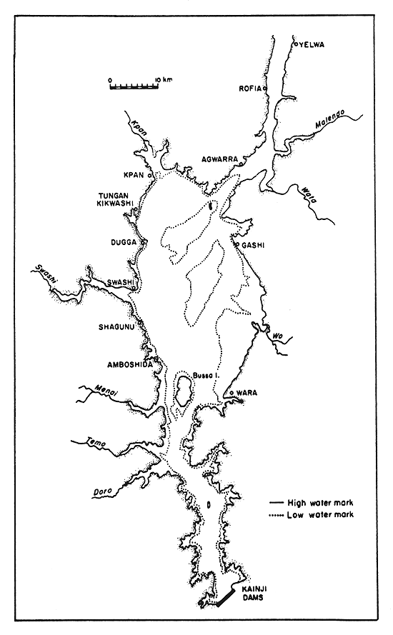
Map 17 Lake Kainji
Carte 17 Lac Kainji
| Tele | Télé |
| Area: 73 mi2 | Superficie: 190 km2 |
| Maximum length: 19 mi | Longueur maximum: 30 km |
| Maximum depth: 16 ft | Profondeur maximum: 5 m |
| Volume: 12 350 × 106 ft3 | Volume: 350 × 106 m3 |
| KAINJI (Reservoir) (Map 17) | KAINJI (lac artificiel) (Carte 17) |
Location: Nigeria | Emplacement: Nigeria |
| Altitude: 460 ft (when full) | Altitude: 142 m (quand il est plein) |
| Surface area: 485 mi2 | Superficie: 1 270 km2 |
| Depth: 195 ft (max); 36 ft (mean) | Profondeur: 60 m (max); 11 m (en moyenne) |
| Volume: 493 × 109 ft3 | Volume: 13,97 × 10⁹ m3 |
| Maximum length: 85 mi | Longueur maximum: 136,8 km |
| Maximum width: 15 mi | Largeur maximum: 24,1 km |
| Shoreline length: 447 mi | Longueur des berges: 716 km |
| Annual fluctuation in level: 32.7–36.0 ft | Fluctuation annuelle du niveau: 10–11 m |
| Inflowing river: Niger | Tributaire: Niger |
| Outflowing river: Niger | Emissaire: Niger |
| Catchment area: 0.62 × 10⁶ mi2 | Bassin versant: 1.6 × 10⁶ km2 |
| Conductivity: K20 46.6–99.6 μ mhos | Conductivité: K20 46,6–99,6 μ mhos |
| Surface temperature: 23–31°C | Température à la surface: 23–31°C |
| Dissolved solids: 50 mg/l | Solides dissous: 50 mg/l |
| pH: 6.0–7.6 | pH: 6,0–7,6 |
| Number of fishermen: 6 320 | Nombre de pêcheurs: 6 320 |
| Number of boats: 3 415 canoes | Nombre de bateaux: 3 415 pirogues |
| Total annual catch: 7 200 t | Captures annuelles totales: 7 200 tonnes |
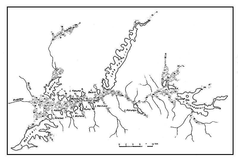
| LAKES OF THE TOUBOURI DEPRESSION | LACS DE LA DEPRESSION DE TOUBOURI |
| A group of four lakes, Fianga (11 mi2), Léré, Tikem (5.4 mi2) and Tréné (4.6 mi2) situated on the Mayo Kebbi River of which the largest is Lake Léré with the following characteristics. | Quatre lacs se trouvent le long du fleuve Mayo Kebbi: Fianga (28 km2), Léré, Tikem (14 km2) et Tréné (12 km2). Le plus grand d'entre eux est le lac Léré qui présente les caractéristiques suivantes. |
| Lere (Map 3) | Léré (Carte 3) |
Location: Cameroon, Chad | Emplacement: Cameroun, Tchad |
| Altitude: 756 ft | Altitude: 231 m |
| Surface area: 15.6 mi2 | Superficie: 40,5 km2 |
| Depth: 26 ft (max); 15 ft (mean) | Profondeur: 8 m (max); 4,5 m (en moyenne) |
| Volume: 5 600 × 106 ft3 | Volume: 160 × 106 m3 |
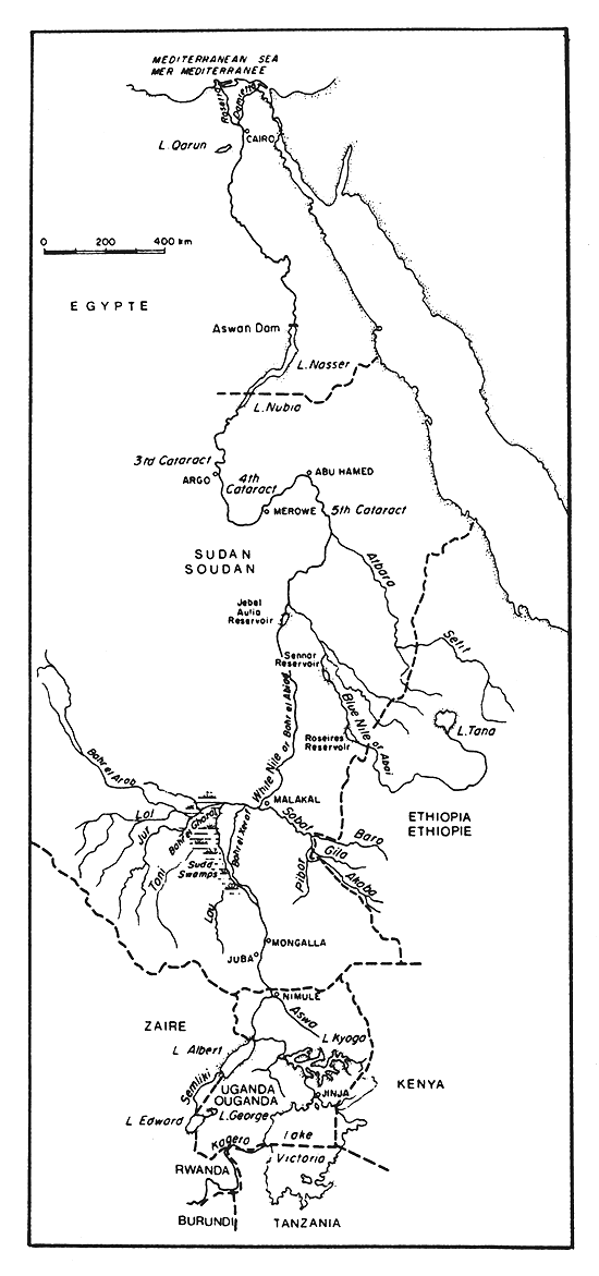
Map 18 Rivers and lakes of the Nile System
Carte 18 Fleuves et lacs du système du Nil
| Maximum length: 8.1 mi | Longueur maximum: 13 km |
| Maximum width: 3 mi | Largeur maximum: 4,8 km |
| Major inflowing river: Mayo Kebbi | Principal tributaire: Mayo Kebbi |
| Outflowing river: Mayo Kebbi | Emissaire: Mayo Kebbi |
| Physical and chemical data: after LEVEQUE, 1971 | Données physiques et chimiques: d'après LEVEQUE, 1971 |
Conductivity | K25 89 μ mhos | Conductivité |
Surface temperature | 20.5–25.2°C | Température à la surface |
pH | 8 | pH |
Ca | 0.5 meq/l | Ca |
Mg | 0.22 meq/l | Mg |
Na | 0.100 meq/l | Na |
K | 0.046 meq/l | K |
HCO3 | 0.90 meq/l | HCO3 |
Sio2 | 32 meq/l | Sio2 |
| THE NILE SYSTEM (Map 18) | SYSTEME DU NIL (Carte 18) |
| Rivers | Fleuves |
| Nile | Nil |
| The Nile takes its source at the confluence of the Blue Nile and White Nile at Khartoum 2 380 mi from the mouth. The longest continuous stream which measures 4 160 mi is the Nile River, White Nile River, Lake Victoria, Kagera River and Akanyaru River. | Le Nil prend sa source au confluent du Nil Bleu et du Nil Blanc à Khartoum, à 3 800 km de son embouchure. La voie d'eau ininterrompue la plus longue qui mesure 6 669 km est constitué par le Nil, le Nil Blanc, le lac Victoria, le fleuve Kagera et le fleuve Akanyaru. |
| Drainage area: 1 160 000 mi2 | Bassin hydrographique: 3 000 000 km2 |
Countries traversed: The Nile basin includes part of Burundi, Egypt, Ethiopia, Kenya, Rwanda, Sudan, Tanzania and Uganda. | Pays traversés: Le bassin du Nil occupe une partie du Burundi, de l'Egypte, de l'Ethiopie, du Kenya, du Rwanda, du Soudan, de la Tanzanie et de l'Ouganda. |
| Major tributaries: Atbara, Blue Nile, White Nile | Principaux affluents: Atbara, Nil Bleu, Nil Blanc |
Discharges to: Mediterranean sea through a delta consisting of the Damietta and Rosetta arms. | Se jette dans: La mer Méditerranée par un delta formé par les bras qui portent les noms de Damiette et de Rosette. |
| Volume of discharge at mouth: 100 000 ft3/sec. | Débit à l'embouchure: 2 832 m3/sec. |
| Suspended silt load: 103 200 t/year | Charge de vase en suspension: 103 200 t/an |
Special features: The cataracts, Lake Nasser/Nubia, Aswan Dam | Caractéristiques particulières: Chutes, lac Nasser/Nubie, Barrage d'Assouan |
| Total annual catch: ± 88 000 t excluding | Captures annuelles totales: ± 88 000 tonnes non |
| catch from lakes | compris les captures des lacs |
| Number of fish species: 81 (BOULENGER, 1907) | Nombre d'espèces de poissons: 81 (BOULENGER, 1907) |
| WHITE NILE (Map 18) | NIL BLANC (Carte 18) |
| The White Nile changes its name several times in its course. From Lake Victoria to Lake Albert it is known as the Victoria Nile. From Lake Albert to the Uganda border it is known as the Albert Nile and from the Sudan to its confluence with the Blue Nile it is called the White Nile or Bahr el Abiad. | Le Nil Blanc change de nom plusieurs fois sur son cours. Du lac Victoria au lac Albert il est connu sous le nom de Nil Victoria. Du lac Albert à la frontière de l'Ouganda il est connu sous le nom de Nil Albert et du Soudan à son confluent avec le Nil Bleu il s'appelle Nil Blanc ou Bahr el Abiad. |
| Source: Owen Falls dam, Uganda | Source: Barrage sur les Owen Falls, Ouganda |
| Altitude: 3 700 ft | Altitude: 1 136 m |
| Total length: 1 300 mi | Longueur totale: 2 084 km |
| Countries traversed: Sudan, Uganda | Pays traversés: Soudan, Ouganda |
Major tributaries: Aswa, Bahr el Ghazal, Sobat, Semliki (via Lake Albert), Kagera (via Lake Victoria) | Principaux affluents: Aswa, Bhar el Ghazal, Sobat, Semliki (par le lac Albert), Kagera (par le lac Victoria). |
| Discharges to: Nile at Khartoum | Se jette dans: Le Nil à Khartoum |
| Volume of discharge: mean 2 500 × 106 ft3/day | Débit: en moyenne 71 × 106 m3/jour |
| The White Nile contributes 10 percent of the total flow during the summer floods and 83 percent at low water. | Le Nil Blanc apporte 10 pour cent des eaux totales pendant les crues d'été et 83 pour cent quand les eaux sont basses. |
Special features: Lake Kyoga, Murchison falls, Lake Albert (Uganda), Sudd, Jebel Aulia reservoir (Sudan) | Caractéristiques particulières: Lac Kyoga, Murchison Falls, lac Albert (Ouganda), Sudd, lac artificiel de Jebel Aulia (Soudan) |
| Physical and chemical data: after TALLING, 1957 | Données physiques et chimiques: d'après TALLING, 1957 |
| Distance from source | 800 km | 1 200 km | 2 000 km | Distance depuis la source |
| (Lake Victoria) | 500 mi | 750 mi | 1 250 mi | (Lac Victoria) |
Conductivity | K20 180–230 μ mhos | K20 190–240 μ mhos | K20 150–180 μ mhos | Conductivité |
pH | 7.9 | 7.1–7.3 | 7.2–7.8 | pH |
Temperature | 28.0–29.0°C | 27.0–28.0°C | 24.0–28.5°C | Température |
Si2 | 2.5–5 mg/l | 4–5.5 mg/l | 7.5–11.5 mg/l | Si2 |
PO4.P | 0.04–0.06 mg/l | 0.02–0.09 mg/l | 0.04–0.09 mg/l | PO4.P |
NH3.N | 0.02–0.04 mg/l | 0.04–0.08 mg/l | 0.04–0.07 mg/l | NH3.N |
NO3.N | 0.02–0.06 mg/l | 0.01–0.06 mg/l | 0.01–0.10 mg/l | NO3.N |
SO4 | 5 mg/l | 1 mg/l | 1 mg/l | SO4 |
Fe | 0.1–0.3 mg/l | 0.4–1.4 mg/l | 0.2–0.7 mg/l | Fe |
Cl | 7–10 mg/l | 6–11 mg/l | 2–6 mg/l | Cl |
Ca | 7 mg/l | 7–9 mg/l | 8–10 mg/l | Ca |
| BAHR EL GHAZAL (Map 18) | BAHR EL GHAZAL (Carte 18) |
| Source: Sudan, Congo-Zaire, Nile watershed | Source: Soudan, Congo-Zaïre, bassin du Nil |
| Discharges to: The Sudd | Se jette dans: Le Sudd |
| Volume of discharge at mouth: 63.5 × 106 ft3/day | Débit à l'embouchure: 1,8 × 10⁶ m3/jour |
| Physical and chemical data: after TALLING, 1957 | Données physiques et chimiques: d'après TALLING, 1957 |
| Conductivity | 550 μ mhos | Conductivité |
| pH | 7.8 | pH |
| NH3.N | 0.1 mg/l | NH3.N |
| PO4.P | 0.02 mg/l | PO4.P |
| Si | 18 mg/l | Si |
| Cl | < 2 mg/l | Cl |
| SOBAT (Map 18) | SOBAT (Carte 18) |
| Volume of discharge at mouth: 1 310 × 106 ft3/day | Débit à l'embouchure: 37 × 106 m3/jour |
| Physical and chemical data: after TALLING, 1957 | Données physiques et chimiques: d'après TALLING, 1957 |
| Conductivity | K20 112 μ mhos | Conductivité |
| pH | 6.8 | pH |
| NO3.N | 0.015 mg/l | NO3.N |
| NH3.N | 0.02 mg/l | NH3.N |
| PO4.P | 0.045 mg/l | PO4.P |
| Si | 12 mg/l | Si |
| Cl | 2 mg/l | Cl |
| Ca | 8.7 mg/l | Ca |
| SO4 | 1.5 mg/l | SO4 |
| BLUE NILE (Map 18) | NIL BLUE (Carte 18) |
| Source: Lake Tana, Ethiopia | Source: Lac Tana, Ethiopie |
| Altitude: 5 960 ft | Altitude: 1 829 m |
| Total length: 912 mi of which 625 are in Ethiopia | Longueur totale: 1 460 km dont 1 000 km se trouvent en Ethiopie |
| Drainage area: 126 000 mi2 | Bassin hydrographique: 325 000 km2 |
| Countries traversed: Ethiopia, Sudan | Pays traversés: Ethiopie, Soudan |
| Major tributaries: Dinder, Rahad | Principaux affluents: Dinder, Rahad |
| Discharges to: Nile at Khartoum | Se jette dans: Le Nil à Khartoum |
Volume of discharge at mouth: 58 000 ft3/sec. | Débit à l'embouchure: 1 640 m3/sec. |
| Contributes 68 percent of summer flood (July to October) to Nile (HURST and PHILLIPS, 1938) | Fournit 68 pour cent des eaux pendant les crues d'été (juillet à octobre) au Nil (HURST et PHILLIPS, 1938) |
Special features: Tissisat Falls (Ethiopia), Roseires reservoir, Sennar reservoir (Sudan) | Caractéristiques particulières: Tissisat Falls (Ethiopie), lac artificiel de Roseires, lac artificiel de Sennar (Soudan) |
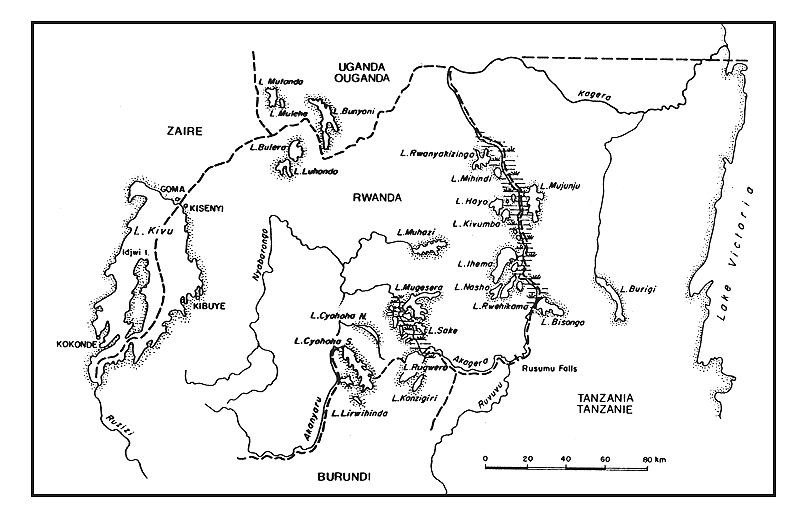
| KAGERA (Map 23) | KAGERA (Carte 23) |
| Source: Burundi/Rwanda | Source: Burundi/Rwanda |
| Total length: 490 mi | Longueur totale: 785 km |
| Countries traversed: Burundi, Rwanda, Tanzania, Uganda | Pays traversés: Burundi, Rwanda, Tanzanie, Ouganda |
| Major tributary: Akanyaru | Principal affluent: Akanyaru |
| Discharges to: Lake Victoria | Se jette dans: Le lac Victoria |
Special features: Lakes Rugwero and Cyohoha (Burundi/Rwanda). Other lakes (Rwanda/Tanzania), Rusumo Falls (Rwanda). | Caractéristiques particulières: Lacs Rugwero et Cyohoha (Burundi/Rwanda). Autres lacs (Rwanda/Tanzanie), Rusumo Falls (Rwanda). |
| Physical and chemical data: after TALLING and | Données physiques et chimiques: d'après TALLING et |
| TALLING, 1965 | TALLING, 1965 |
| Conductivity | K20 99 μ mhos | Conductivité |
| Ca | 5.4 mg/l | Ca |
| Mg | 4.1 mg/l | Mg |
| HCO3 + CO3 | 0.86 meq/l | HCO3 + CO3 |
| SiO2 | 17 mg/l | SiO2 |
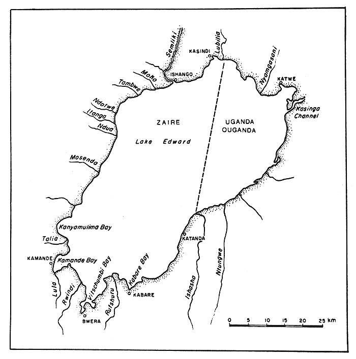
| SEMLIKI (Map 18) | SEMLIKI (Carte 18) |
| Source: Zaire, Lake Edward | Source: Zaïre, lac Edouard |
| Altitude: 2 015 ft | Altitude: 619 m |
| Countries traversed: Uganda, Zaire | Pays traversés: Ouganda, Zaïre |
| Discharges to: Lake Albert | Se jette dans: Le lac Albert |
| Physical and chemical data: | Données physiques et chimiques: |
Conductivity |
K20 400–910 u mhos (BEAUCHAMP, 1956) | Conductivité | |
| EAFRO, 1952b | VAN DER BEN, 1959 | ||
| Ca | 15 mg/l | Ca | |
| HCO3 + CO3 | 7.16 meq/l | 7.3 meq/l | HCO3 + CO3 |
| Cl | 30.7 mg/l | Cl | |
| SO4 | 36.4 mg/l | SO4 | |
| SiO2 | 24 mg/l | 3.8 mg/l | SiO2 |
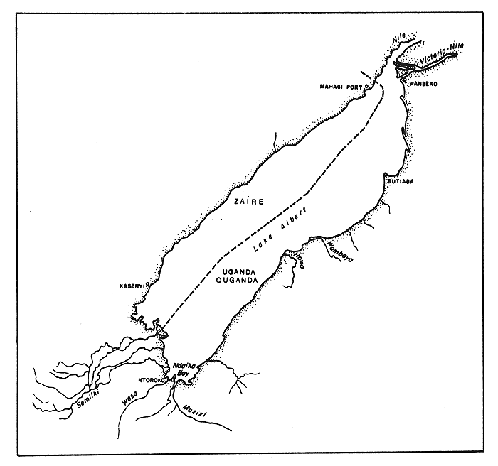
Map 19 Lake Albert
Carte 19 Lac Albert
| Lakes | Lacs | ||||||
| Albert (Map 19) | Albert (Carte 19) | ||||||
Location: Uganda, Zaire | Emplacement: Ouganda, Zaïre | ||||||
| Altitude: 2 190 ft | Altitude: 619 m | ||||||
| Surface area: | Uganda | 1 230 | mi2 (57%) | Superficie: | Ouganda | 3 180 | km2 (57%) |
| Zaire | 955 | mi2 (43%) | Zaïre | 2 420 | km2 (43%) | ||
| total | 2 185 | mi2 | totale | 5 600 | km2 | ||
| Depth: 190 ft (max); 81 ft (mean) | Profondeur: 58 m (max); 25 m (en moyenne) | ||||||
| Volume: 4 930 × 109 ft3 | Volume: 140 × 109 m3 | ||||||
| Maximum length: 113 mi | Longueur maximum: 180 km | ||||||
| Maximum width: 25 mi | Largeur maximum: 40 km | ||||||
| Major inflowing rivers: Semliki, Victoria Nile | Principaux tributaires: Semliki, Nil Victoria | ||||||
| Outflowing river: Albert Nile | Emissaire: Nil Albert | ||||||
| Physical and chemical data: | Données physiques et chimiques: | ||||||
| Conductivity | K20675 (TALLING, 1957)-730 (TALLING, 1963) μ mhos | Conductivité |
| Surface temperature | 26–29°C | Température à la surface |
| Dissolved solids | 565 mg/l | Solides dissous |
| pH | 8.4–9.5 | pH |
| VAN DER BEN 1955 | TALLING AND TALLING 1965 | ||
Na | 97 mg/l | 91 mg/l | Na |
K | 66 mg/l | 65 mg/l | K |
Ca | 9.3 mg/l | 9.8 mg/l | Ca |
Mg | 31.5 mg/l | 32.1 mg/l | Mg |
HCO3 + CO3 | 7.8 meq/l | 7.3 meq/l | HCO3 + CO3 |
Cl | 31 mg/l | 31 mg/l | Cl |
SO4 | 25 mg/l | 32 mg/l | SO4 |
SiO2 | 3.4 mg/l | 0.09–0.9 mg/l | SiO2 |
NO3.N | 9 μg/l | - | NO3.N |
PO4.P | 130 μg/l | - | PO4.P |
total P | - | 200 μg/l | P total |
| Total annual catch: | Captures annuelles totales: | ||||
| Uganda | 17 530 t (1969) | Ouganda | 17 530 tonnes (1969) | ||
| Zaire | 10 700 t (1970) | Zaïre | 10 700 tonnes (1970) | ||
| total | 28 230 t | totales | 28 230 tonnes | ||
| Estimated maximum sustained yield: | Taux estimé des captures maximales équilibrées: | ||||
| Uganda | 20 000 t | Ouganda | 20 000 tonnes | ||
| Zaire | 12 000 t | Zaïre | 12 000 tonnes | ||
| total | 32 000 t | total | 32 000 tonnes | ||
| Number of fish species: 46 (GREENWOOD, 1964) | Nombre d'espèces de poissons: 46 (GREENWOOD, 1964) | ||||
Map 20 The Ankoke and Koki Lakes of Uganda
Carte 20 Lacs Ankole et Koki d'Ouganda
| ANKOLE AND KOKI LAKES (Map 20) | LACS ANKOLE ET KOKI (Carte 20) | ||||
| A complex of three large lakes, Kachira, Kijanebolola and Nakivali, and several smaller ones in the region between Lake Victoria and Lake Edward. | Ensemble de trois grands lacs (Kachira, Kijanebolola et Nakivali) et plusieurs plus petits lacs situés dans la région qui s'étend entre le lac Victoria et le lac Edouard. | ||||
| Dimensions: | Lake Kachira | 12.5 × 2.2 mi | Dimensions: | Lac Kachira | 20.0 × 3,5 km |
| Lake Kijanebolola | 7.2 × 3.1 mi | Lac Kijanebolola | 11.5 × 5,0 km | ||
| Lake Nakivali | 8.2 × 3.7 mi | Lac Nakivali | 14.0 × 6 km | ||
| Outflowing river: Kibale River discharging to Lake Victoria | Emissaire: Rivière Kibale qui se jette dans le lac Victoria | ||||
| EDWARD (Map 21) | EDOUARD (Carte 21) | ||||||
Location: Uganda, Zaire | Emplacement: Ouganda, Zaïre | ||||||
| Altitude: 3 000 ft | Altitude: 914 m | ||||||
| Surface area: | Uganda | 259 | mi2 (29%) | Superficie: | Ouganda | 670 | km2 (29%) |
| Zaire | 629 | mi2 (71%) | Zaïre | 1 630 | km2 (71%) | ||
| total | 888 | mi2 | totale | 2 300 | km2 | ||
| Depth: 383 ft (max); 111 ft (mean) | Profondeur: 117 m (max); 34 m (en moyenne) | ||||||
| Volume: 2 760 × 109 ft3 | Volume: 78,2 × 10⁹ m3 | ||||||
| Maximum length: 56 mi | Longueur maximum: 90 km | ||||||
| Maximum width: 25 mi | Largeur maximum: 40 km | ||||||
Major inflowing rivers: Rutshuru, also connected to Lake George by the Kasinga Channel. | Principaux tributaires: Rutshuru, rejoint aussi au lac George par le canal de Kasinga. | ||||||
| Outflowing river: Semliki | Emissaire: Semliki | ||||||
| Physical and chemical data: | Données physiques et chimiques: | ||||||
| Conductivity | K20 900 (EAFRO, 1954)-925 (TALLING & TALLING, 1965) μ mhos | Conductivité |
| Surface temperature | ± 26°C | Température à la surface |
| Dissolved solids | 521 mg/l | Solides dissous |
| pH | 8.5–9.3 | pH |
TALLING & TALLING, 1965 | ||
Na | 110 mg/l | Na |
K | 9.0 mg/l | K |
Ca | 12.4 mg/l | Ca |
Mg | 47.8 mg/l | Mg |
| HCO3 + CO3 | 9.85 meq/l | HCO3 + CO3 |
Cl | 36 mg/l | Cl |
SO4 | 31 mg/l | SO4 |
SiO2 | 6.5 mg/l | SiO2 |
NO3N | 24 μg/l | NO3N |
PO4.P | 18 μg/l | PO4.P |
Total P | 127 μg/l | P total |
Map 21 Lake Edward
Carte 21 Lac Edouard
Map 22 Lake George and the surrounding crater lakes
Carte 22 Lac George et lacs de cratères avoisinants
| Total annual catch: | Captures annuelles totales: | ||
Uganda | 5 731 t (1970) | Ouganda | 5 731 tonnes (1970) |
Zaire | 10 351 t (1969) | Zaïre | 10 351 tonnes (1969) |
total | 16 031 t | totales | 16 031tonnes |
| Estimated maximum sustained yield: 22 000 t | Taux estimé des captures maximales équilibrées: 22 000 tonnes | ||
Number of fish species: 53 of which 28 are cichlids (GREENWOOD, 1964) | Nombre d'espèces de poissons: 53 dont 28 sont des cichlidés (GREENWOOD, 1964) | ||
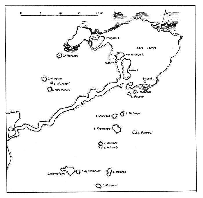
| GEORGE (Map 22) | GEORGE (Carte 22) |
Location: Uganda | Emplacement: Ouganda |
| Altitude: 3 000 ft | Altitude: 914 m |
| Surface area: 104 mi2 | Superficie: 270 km2 |
| Depth: 23.6 ft (max); 8 ft (mean) | Profondeur: 7 m (max); 2,5 m (en moyenne) |
| Volume: 17.7 × 109 ft3 | Volume: 0,5 × 10⁹ m3 |
| Maximum length: 14.4 mi | Longueur maximum: 23 km |
| Maximum width: 11.3 mi | Largeur maximum: 18 km |
| Outflowing river: Semliki channel to Lake Edward | Emissaire: Semliki qui va rejoindre le lac Edouard |
| Catchment area: 3 470 mi2 | Bassin versant: 9 000 km2 |
| Physical and chemical data: | Données physiques et chimiques: |
| Conductivity | K20 165 (EAFFRO, 1953)-207 (BEADLE, 1932) μ mhos | Conductivité |
| Surface temperature | 25–35°C | Température à la surface |
| Dissolved solids | 264 mg/l (HURST, 1925) | Solides dissous |
| pH | 8.5–9.5(DUNN et al., 1969) | pH |
DUNN et al., 1969 | ||
| HCO3 | 1.5–2.0 meq/l | HCO3 |
| Ca | 1.0 meq/l | Ca |
| Mg | 0.6 meq/l | Mg |
| Na | 0.8 meq/l | Na |
| P.PO4 | ca 250 μg/l | P.PO4 |
| N | ca 2 000 μg/l | N |
| Fe | 500 μg/l | Fe |
| SiO2 | 20 mg/l | SiO2 |
| Total annual catch: | 2 438 t (1967) | Captures annuelles totales: | 2 438 tonnes (1967) |
| 3 950 t (1969) | 3 950 tonnes (1969) | ||
| 4 242 t (1970) | 4 242 tonnes (1970) |
Map 23 Lake Kivu and the Kagera river lakes
Carte 23 Lac Kivu et lacs du fleuve Kagera
| JEBEL AULIA (Reservoir) (Map 18) | JEBEL AULIA (lac artificiel (Carte 18) |
Location: Sudan | Emplacement: Soudan |
| Altitude: 1 210 ft | Altitude: 377 m |
| Surface area: 232 mi2 (max) | Superficie: 600 km2 (max) |
| Depth: 39 ft (max); 19 ft (mean) | Profondeur: 12 m (max); 6 m (en moyenne) |
| Volume: 124 × 109 ft3 | Volume: 3,5 × 10⁹ m3 |
| Major inflowing river: White Nile | Principal tributaire: Nil Blanc |
| Physical and chemical data: | Données physiques et chimiques: |
| Surface temperature | 21.0–29.5°C | Température à la surface | ||
| Dissolved solids | dam end | 180 mg/l | sortie du barrage | Solides dissous |
| (BROOK AND RZOSKA, 1954) | river end | 120 mg/l | arrivée de la rivière | (BROOK ET RZOSKA, 1954) |
| pH | dam end | 9.2 | sortie du barrage | pH |
| (BROOK AND RZOSKA, 1954) | river end | 7.5 | arrivée de la rivière | (BROOK ET RZOSKA, 1954) |
| (TALLING, 1957) | centre | 8.0–8.3 | au centre du lac | (TALLING, 1957) |
| TALLING, 1957 | ||||
| CaCO3 | 65–70 mg/l | CaCO3 |
| Si | 6.11 mg/l | Si |
| PO4.P | 0.04–0.10 mg/l | PO4.P |
| NH3.N | 0.04–0.06 mg/l | NH3.N |
| NO3.N | 0.02–0.06 mg/l | NO3.N |
| SO4 | 1 mg/l | SO4 |
| Fe | 0.1–0.5 mg/l | Fe |
| Cl | 3–7 mg/l | Cl |
| Ca | 8–11 mg/l | Ca |
| KAGERA RIVER LAKES (Map 23) | LACS SUR LES COURS DE LA KAGERA (Carte 23) |
| This group of lakes, situated in Burundi, Rwanda and Tanzania, is drained by the Kagera River or by its tributaries the Akanyaru and Nyabarongo River. The lakes are generally divided into two groups, the Bugesera lakes, which are situated above the Rusumo Falls and the Rusumo-Migongo lakes situated below the falls. The Rusumo Falls themselves have prevented colonization of the Bugesera lakes by many species of fish, and there are considerable faunal differences between the two groups. | Ce groupe de lacs, situés au Burundi, au Rwanda et en Tanzanie, sont alimentés par la Kagera ou par ses affluents l'Akanyaru et le Nyabarongo. Les lacs sont généralement divisés en deux groupes, les lacs Bugesera, situés au-dessus des chutes de Rusumo, et les lacs Rusumo-Migongo situés en-dissous des chutes. Ce sont précisément les chutes de Rusumo qui interdisent l'introduction de diverses espèces de poissons dans les lacs de Bugesera, et on constate des différences considérables entre les faunes des deux groupes. |
Map 24 Lakes of the Kyoga System
Carte 24 Lacs du système du Kyoga
| Upper Kagera Lakes | Lacs du cours supérieur de la Kagera |
| Altitude: about 4 600 ft | Altitude: environ 1 400 m |
| Rwanda: Birira (2 mi2), Cyohoha N. (2.3 mi2), | Rwanda: Birira (5,4 km2), Cyohoha du nord (6,0 km2), |
| Gaharwa (0.9 mi2), Gashanga, Kirimbi (0.9 mi2), | Gaharwa (2,3 km2), Gashanga, Kirimbi (2,3 km2) |
| Mirayi (0.9 mi2), Mugesera (15.2 mi2), | Mirayi (2,3 km2), Mugesera (39,2 km2), |
| Muhazi (13.2 mi2), Rumira (0.9 mi2), | Muhazi (34,1 km2), Rumira (2,2 km2), |
| Sake (5.5 mi2). | Sake (14,3 km2). |
| Burundi: Kakamurindi, Kanzigiri, Lirwihindi | Burundi: Kakamurindi, Kanzigiri, Lirwihindi |
Burundi/Rwanda: Cyohoha S.; Rwanda (2.4 mi2 total about 9.3 mi2). Rugwero, Rwanda (7.7 mi2 total about 38.6 mi2). | Burundi/Rwanda: Cyohoha du sud; Rwanda (6,3 km2 total environ 24 km2). Rugwero, Rwanda (20 km2 total environ 100 km2). |
| The physical and chemical data on these lakes are not abundant, pH varies between 7–8 and in Lake Rugwero the conductivity is K20 135 μ mhos and dissolved solids are 130 mg/l (DAMAS, 1954). Temperatures generally range between 21–25°C. | Les données physiques et chimiques concernant ces lacs sont peu abondantes, le pH varie entre 7 et 8 dans le lac Rugwero la conductivité est de K20 135 μ mhos et la concentration de solides dissous de 130 mg/l (DAMAS, 1954). Les températures sont généralement comprises entre 21 et 25 °C. |
| Lower Kagera Lakes | Lacs du cours inférieur de la Kagera |
| Altitude: about 4 250 ft | Altitude: environ 1 300 m |
Rwanda: Hago, Ihema (± 396 mi2), Iwapibali (1 mi2), Kivumba, Mihindi, Nasho, Rwehikama (8.3 mi2), Rwampanga (3.7 mi2), Rwanyakizinga | Rwanda: Hago, Ihema (± 100 km2), Iwapibali (3,6 km), Kivumba, Mihindi, Nasho, Rwehikama (21,6 km2), Rwampanga (9,5 km2), Rwanyakizinga |
| Tanzania: Bisongo, Mujunju | Tanzanie: Bisongo, Mujunju |
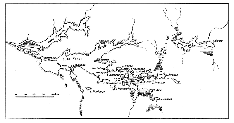
| KYOGA SYSTEM (Map 24) | SYSTEME DE LA KYOGA (Carte 24) |
| The Kyoga system consists of a group of lakes and swamps centred around Lake Kyoga, Lake Bisinia and Lake Kwania. | Le système de la Kyoga se compose d'un groupe de lacs et de marais situés autour du lac Kyoga, du lac Bisinia et du lac Kwania. |
| Lake Kyoga | Lac Kyoga |
Location: Uganda | Emplacement: Ouganda |
| Altitude: 3 600 ft | Altitude: 1 100 m |
| Surface area: 1 040 mi2 | Superficie: 2 700 km2 |
| Depth: 26 ft (max); 19 ft (mean) | Profondeur: 8 m (max); 6 m (en moyenne) |
| Physical and chemical data: |
Données physiques et chimiques: | |
| Conductivity | K20 245–365 μ mhos (BEAUCHAMP, 1956) | Conductivité |
| Surface temperature | ± 28.0°C | Température à la surface |
| pH | 7.6–9.0 | pH |
| EAFRO, 1954 | ||
Na | 10.8 mg/l | Na |
K | 9.6 mg/l | K |
Ca | 21.7 mg/l | Ca |
Mg | 13.8 mg/l | Mg |
HCO3 + CO3 | 2.18 meq/l | HCO3 + CO3 |
Cl | 12.0 mg/l | Cl |
SO4 | 31 mg/l | SO4 |
SiO2 | 34 mg/l | SiO2 |
NO2.N | 22 μg/l | NO2.N |
PO4.P | 220 μg/l | PO4.P |
Total P | 272 μg/l | P total |
| Total annual catch: 48 900 t (1969) | Captures annuelles totales: 48 900 tonnes (1969) | ||||||
| NASSER/NUBIA (Map 18) | NASSER/NUBIE (Carte 18) | ||||||
| Lake Nasser/Nubia is typically an intermediate water reservoir with characteristics of both the lowest section of a river and of a lake. Floods occur in August-September causing fundamental changes in limnological conditions and equal oxygenation of all water layers. In May-July the lowering of the water level causes stagnation of the water masses. | Le lac Nasser/Nubie est un lac artificiel intermédiaire présentant les caractéristiques à la fois de la partie inférieure d'un fleuve et d'un lac. Les crues ont lieu en août-septembre et provoquent des modifications profondes des conditions limnologiques et une oxygénation égale de toutes les couches d'eau. De mai à juillet, l'abaissement du niveau d'eau est tel que les eaux stagnent. | ||||||
Location: Egypt (Lake Nasser), Sudan (Lake
Nubia). | Emplacement: Egypte (lac Nasser), Soudan
(lac Nubie). | ||||||
| Altitude: 604 ft | Altitude: 185 m | ||||||
| Surface area: | Lake Nasser | 965 | mi2 | Superficie: | lac Nasser | 2 500 | km2 |
| Lake Nubia | 320 | mi2 | lac Nubie | 830 | km2 | ||
| total | 1 285 | mi2 (1972) | totale | 3 330 | km2 (1972) | ||
| approximately half full | approximativement à moitié plein | ||||||
| final area about 1 930 mi2 | superficie finale d'environ 5 000 km2 | ||||||
| Depth: 317 ft (max); 82 ft (mean) when full | Profondeur: 97 m (max); 25 m (en moyenne) quand ils sont pleins | ||||||
| Volume: 4 590 × 109 ft3 when full | Volume: 130 × 109 m3 quand ils sont pleins | ||||||
| Maximum length: 305 mi | Longueur maximum: 490 km | ||||||
| Maximum width: 12.5 mi | Largeur maximum: 20 km | ||||||
Annual fluctuation in level: 32.7–53.3 ft (1970); 22.9–32.7 ft (when full) | Fluctuation annuelle du niveau: 10–16 m (1970); 7–10 m (quand ils sont pleins) | ||||||
| Major inflowing river: Nile | Principal tributaire: Nil | ||||||
| Outflowing river: Nile | Emissaire: Nil | ||||||
| Conductivity: K20 210–250 μ mhos | Conductivité: K20 210–250 μ mhos |
| Dissolved solids: 260 mg/l | Solides dissous: 260 mg/l |
| Surface temperature: summer 17–32°C at winter overturn 18°C | Température à la surface: été 17–32°C au renouvellement d'hiver 18°C |
| pH: 7.6 (mean) | pH: 7,6 (en moyenne) |
| Number of fishermen: 3 500 | Nombre de pêcheurs: 3 500 |
| Number of boats: 1 100 | Nombre de bateaux: 1 100 |
| Total annual catch: 7 000 t (1971) Lake Nasser | Captures annuelles totales: 7 000 tonnes (1971) lac Nasser |
| Estimated maximum sustained yield: 15 000 t | Taux estimé des captures maximales équilibrées: 15 000 tonnes |
| QARUN (Map 18) | KAROUN (Carte 18) |
Location: Egypt | Emplacement: Egypte |
| Altitude: - 147 ft | Altitude: - 45 m |
| Surface area: 85 mi2 | Superficie: 220 km2 |
| Depth: 26 ft (max); 11.5 ft (mean) | Profondeur: 8 m (max); 3,5 m (en moyenne) |
| Total annual catch: 10 000 t | Captures annuelles totales: 10 000 tonnes |
| Lake Qarun was originally a fresh water body, but since 1920 the salinity has risen to a level of 10–20 percent. The freshwater fauna has virtually disappeared and the lake has since been stocked with a variety of brackishwater species. | Le lac de Karoun était à l'origine un lac d'eau douce mais depuis 1920 sa salinité s'est élevée pour atteindre 10 à 20 pour cent. La faune d'eau douce a pratiquement disparue et une variété d'espèce de poisson d'eau saumâtre y a été introduite. |
| ROSEIRES (Reservoir) (Map 18) | ROSEIRES (lac artificiel) (Carte 18) |
Location: Sudan | Emplacement: Soudan |
| Surface area: 112 mi2 | Superficie: 290 km2 |
| Depth: 222 ft (max); 32.7 ft (mean) | Profondeur: 68 m (max); 10 m (en moyenne) |
| Volume: 106 × 109 ft3 | Volume: 3 × 10⁹ m3 |
| Maximum length: 47 mi | Longueur maximum: 75 m |
| Inflowing river: Blue Nile | Tributaire: Nil Bleu |
| Outflowing river: Blue Nile | Emissaire: Nil Bleu |
| SENNAR (Map 18) | SENNAR (Carte 18) |
Location: Sudan | Emplacement: Soudan |
| Altitude: 1 380 ft | Altitude: 422 m |
| Surface area: 54 mi2 | Superficie: 140 km2 |
| Depth: 85 ft (max) | Profondeur: 26 m (max) |
| Annual fluctuation in level: 55 ft | Fluctuation annuelle du niveau: 17 m |
Map 25 Lake Victoria
Carte 25 Lac Victoria
| Major inflowing river: Blue Nile | Principal tributaire: Nil Bleu |
| Outflowing river: Blue Nile | Emissaire: Nil Bleu |
| TANA (Map 18) | TANA (Carte 18) |
Location: Ethiopia | Emplacement: Ethiopie |
| Altitude: 5 960 ft | Altitude: 1 829 m |
| Surface area: 1 350 mi2 | Superficie: 3 500 km2 |
| Depth: 45.7 ft (max); 26 ft (mean) | Profondeur: 14 m (max); 8 m (en moyenne) |
| Volume: 1 000 × 109 ft3 | Volume: 28 × 109 m3 |
| Maximum length: 50 mi | Longueur maximum: 80 km |
| Maximum width: 40 mi | Largeur maximum: 64 km |
Major inflowing rivers: 60 affluents of which the largest are the Little Abbai, the Reb and the Gumura Rivers. | Principaux tributaires: 60 affluents dont les plus grands sont le Petit Abbai, le Reb et le Gumura. |
| Outflowing river: Blue Nile | Emissaire: Nil Bleu |
| Physical and chemical data: | Données physiques et chimiques: |
| Dissolved solids | 151 (BINI, 1940) - 174 (GRABHAM AND BLACK, 1925) mg/l | Solides dissous |
| pH | 7.5–8.2 (BINI, 1940) | pH |
| GRABHAM AND BLACK 1925 | BINI 1940 | ||
Ca | 27.1 mg/l | 18.7 mg/l | Ca |
Mg | 10.0 mg/l | 9.3 mg/l | Mg |
Cl | 8.0 mg/l | 8.0 mg/l | Cl |
SiO3 | 22.0 mg/l | SiO3 | |
HCO3 + CO3 | 1.7 meq/l | HCO3 + CO3 | |
| Total annual catch: 500 t | Captures annuelles totales: 500 tonnes |
| Number of fish species: 20 (BOULENGER, 1907) | Nombre d'espèces de poissons: 20 (BOULENGER, 1907) |
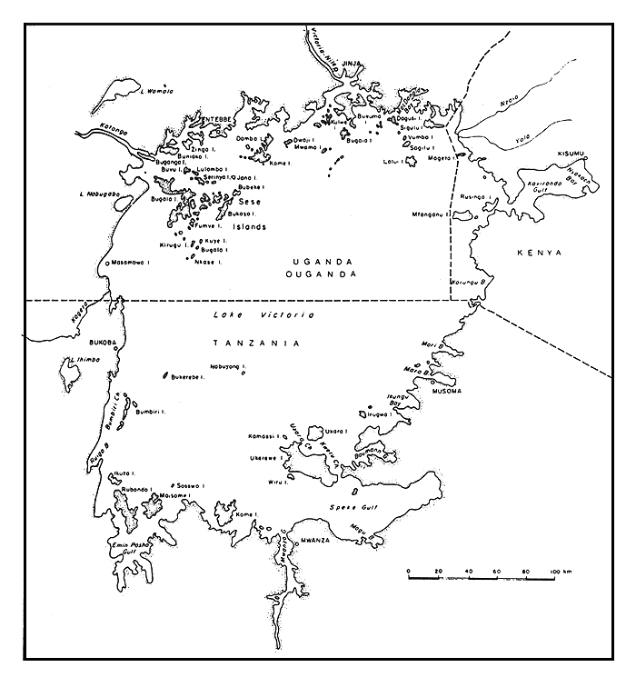
| VICTORIA (Map 25) | VICTORIA (Carte 25) | ||||||
Location: Kenya, Tanzania, Uganda | Emplacement: Kenya,
Tanzanie, Ouganda | ||||||
| Altitude: 3 720 ft | Altitude: 1 136 m | ||||||
| Surface area: | Kenya | 1 600 | mi2 (6%) | Superficie: | Kenya | 4 100 | km2 (6%) |
| Tanzania | 13 000 | mi2 (49%) | Tanzanie | 33 700 | km2 (49%) | ||
| Uganda | 12 000 | mi2 (45%) | Ouganda | 31 000 | km2 (45%) | ||
| total | 26 600 | mi2 | totale | 68 800 | km2 | ||
| Depth: 279 ft (max); 132 ft (mean) | Profondeur: 84 m (max); 40 m (en moyenne) | ||||||
| Maximum length: 250 mi | Longueur maximum: 400 km | ||||||
| Maximum width: 150 mi | Largeur maximum: 240 km | ||||||
| Shoreline length: 2 150 mi | Longueur des berges: 3 440 km | ||||||
| Major inflowing rivers: Kagera, Nzoia, Yala | Principaux tributaires: Kagera, Nzoia, Yala |
| Outflowing river: Victoria Nile | Emissaire: Nil Victoria |
| Catchment area: 99 500 mi2 | Bassin versant: 263 000 km2 |
| Physical and chemical data: | Données physiques et chimiques: |
| Conductivity | K20 91 (EAFFRO, 1952) - 98 (EAFFRO, 1953) μ mhos | Conductivité |
| Surface temperature | 23–28°C | Température à la surface |
| Dissolved solids | 97 mg/l | Solides dissous |
| pH Kavirondo Gulf | 8.2 TALLING AND TALLING, 1965 - 9.0 GRAHAM, 1929 | Golfe de Kavirondo pH |
| Open lake | 8.0 TALLING AND TALLING, 1965 - 8.5 GRAHAM, 1929 | Dans le lac |
| EAFRO, 1952a | TALLING AND TALLING, 1965 | ||
Na | 12.5–13.5 mg/l | 10.4 mg/l | Na |
K | 3.7–4.2 mg/l | 3.8 mg/l | K |
Ca | 5.0–7.0 mg/l | 5.6 mg/l | Ca |
Mg | 2.3–3.5 mg/l | 2.6 mg/l | Mg |
HCO3 + CO3 | 1.0–1.1 meq/l | 0.9 meq/1 | HCO3 + CO3 |
Cl | 3.9 mg/l | Cl | |
SO4 | 0.8 mg/l | SO4 | |
SiO2 | 3–9 mg/l | 4.2 mg/l | SiO2 |
NO2.N | 11 μg/l | NO2.N | |
PO4.P | 13 μg/l | PO4.P | |
Total P | 47 μg/l | P total | |
| Number of fishermen: | 15 000 | Nombre de pêcheurs: | 15 000 | ||||
| Number of boats: | 6 000 | Nombre de bateaux: | 6 000 | ||||
| Total annual catch: | Captures annuelles totales: | ||||||
1969–70 | Kenya | 18 000 | t (18%) | 1969–70 | Kenya | 18 000 | tonnes (18%) |
| Tanzania | 48 292 | t (48%) | Tanzanie | 48 292 | tonnes (48%) | ||
| Uganda | 34 790 | t (34%) | Ouganda | 34 790 | tonnes (34%) | ||
| total | 101 082 | t | totales | 101 082 | tonnes | ||
| Estimated maximum sustained yield: | Taux estimé des captures maximales équilibrées | ||||||
Kenya | 25 000 | t | Kenya | 25 000 | tonnes | ||
Tanzania | 21 500 | t | Tanzania | 21 500 | tonnes | ||
Uganda | 180 000 | t | Ouganda | 180 000 | tonnes | ||
total | 420 000 | t | total | 420 000 | tonnes | ||
Number of fish species: 177 of which 127 are cichlids (GREENWOOD, 1964) | Nombre d'espèces de poissons: 177 dont 127 sont des cichlidés (GREENWOOD, 1964) | ||||||
| THE RIFT VALLEY LAKES | LACS DE LA VALLEE DU RIFT |
| A group of lakes in the rift valley many of which are endorheic and highly saline. | Groupe de lacs situés dans la vallée du rift, nombre d'entre eux étant endoréiques et très salés. |
| ABAYA (Margherita) (Map 4) | ABAYA (Margherita) (Carte 4) |
Location: Ethiopia | Emplacement: Ethiopie |
| Altitude: 4 200 ft | Altitude: 1 285 m |
| Surface area: 450 mi2 | Superficie: 1 161 km2 |
| Depth: 43 ft (max); 23 ft (mean) | Profondeur: 13 m (max); 7 m (en moyenne) |
| Volume: 280 × 109 ft3 | Volume: 8.2 × 10⁹ m3 |
| Maximum width: 44 mi | Largeur maximum: 70 km |
| Maximum length: 17.5 mi | Longueur maximum: 28 km |
| Shoreline length: 140 mi | Longueur des berges: 225 km |
| Major inflowing river: Bilate | Principal tributaire: Bilate |
| Catchment area: 6 700 mi2 | Bassin versant: 17 300 km2 |
| Physical and chemical data: | Données physiques et chimiques: |
| Conductivity | K20 670–766 μ mhos (LOFFREDO AND MALDURA, 1941) | Conductivité |
| Surface temperature | 22–28°C | Température à la surface |
| Dissolved solids | 516.5 mg/l (LOFFREDO AND MALDURA, 1941) | Solides dissous |
| LOFFREDO AND MALDURA, 1941 | TALLING AND TALLING, 1965 | ||
Na | 206 mg/l | Na | |
K | 14.1 mg/l | 16 mg/l | K |
Ca | 15.9 mg/l | 12.1 mg/l | Ca |
Mg | 6.3 mg/l | 5.7 mg/l | Mg |
HCO3 + CO3 | 8.5 meq/l | HCO3 + CO3 | |
Cl | 52 mg/l | 53 mg/l | Cl |
SO4 | 24.6 mg/l | 28 mg/l | SO4 |
SiO4 | 35.5 mg/l | 45 mg/l | SiO4 |
Total P | 290 μg/l | P total | |
| Estimated maximum sustained yield: 7 000 t | Taux estimé des captures maximales équilibrées: 7 000 tonnes |
| ABIYATA (Abiata) (Map 4) | ABIYATA (Abiata) (Carte 4) |
Location: Ethiopia | Emplacement: Ethiopie |
| Altitude: 5 140 ft | Altitude: 1 573 m |
| Surface area: 79 mi2 | Superficie: 205 km2 |
| Depth: 46.5 ft (max); 25 ft (mean) | Profondeur: 14,2 m (max); 7,6 m (en moyenne) |
| Volume: 56.5 × 109 ft3 | Volume: 1,6 × 10⁹ m3 |
| Maximum length: 13 mi | Longueur maximum: 20,9 km |
| Maximum width: 7.7 mi | Largeur maximum: 12,4 km |
| Shoreline length: 38.8 mi | Longueur des berges: 61,9 km |
| Catchment area: 630 mi2 | Bassin versant: 1 630 km2 |
| Physical and chemical data: | Données physiques et chimiques: | |||
| Conductivity | K20 | 10 700 (LOFFREDO AND MALDURA, 1941) - 30 000 (TALLING AND TALLING, 1965) | μ mhos | Conductivité |
| Surface temperature | 23–26°C | Température à la surface | ||
| Dissolved solids | 8 358 mg/l (LOFFREDO AND MALDURA, 1941) | Solides dissous | ||
| LOFFREDO AND MALDURA, 1941 | TALLING AND TALLING, 1965 | ||
Na | 3 000 mg/l | 6 375 mg/l | Na |
K | 75.3 mg/l | 331 mg/l | K |
Ca | 8.5 mg/l | < 3 mg/l | Ca |
Mg | 6.0 mg/l | < 7.5 mg/l | Mg |
HCO3 + CO3 | 210 meq/1 | HCO3 + CO3 | |
Cl | 1 500 mg/l | 3 240 mg/l | Cl |
SO4 | 67.4 mg/l | 210 mg/l | SO4 |
Total P | 890 μg/l | P total | |
The lake forms a water bird reserve. | Le lac est une réserve d'oiseaux aquatiques. |
| AWASA (Map 4) | AWASA (Carte 4) |
Location: Ethiopia | Emplacement: Ethiopie |
| Altitude: 5 560 ft | Altitude: 1 708 m |
Surface area: 50 mi2. The lake forms a swamp of about 28 mi2 to the east. | Superficie: 130 km2. Le lac forme un marais d'environ 72 km2 vers l'est. |
| Depth: 70.5 ft (max); 35 ft (mean) | Profondeur: 21,6 m (max); 10,7 m (en moyenne) |
| Volume: 45.9 × 109 ft3 | Volume: 1,3 × 10⁹ m3 |
| Maximum length: 10.6 mi | Longueur maximum: 17 km |
| Maximum width: 6,9 mi | Largeur maximum: 11 km |
| Shoreline length: 32.5 mi | Longueur des berges: 52 km |
| Catchment area: 483 mi2 | Bassin versant: 1 250 km2 |
| Physical and chemical data: | Données physiques et chimiques: |
| Conductivity | K20 790–860 μ mhos (LOFFREDO AND MALDURA, 1941) | Conductivité |
| K20 1 050 μ mhos (TALLING AND TALLING, 1965) | ||
| Surface temperature | 23–26°C | Température à la surface |
| Dissolved solids | 650.4 mg/l | Solides dissous |
| TALLING AND TALLING, 1965 | ||
Na | 235 mg/l | Na |
K | 45 mg/l | K |
Ca | 4.4 mg/l | Ca |
Mg | 4.7 mg/l | Mg |
HCO3 + CO3 | 10.5 meq/l | HCO3 + CO3 |
Cl | 34 mg/l | Cl |
SO4 | < 2 | SO4 |
SiO2 | 72 mg/l | SiO2 |
Total P | 98 μg/l | P total |
| Number of fishermen: 30 | Nombre de pêcheurs: 30 |
| There is at present little fishery development, although the estimated maximum sustainable yield is 1 000 t. | La pêche est peu développée actuellement bien que le taux estimé de captures maximales équilibrées soit de 1 000 tonnes. |
| BARINGO (Map 4) | BARINGO (Carte 4) |
Location: Kenya | Emplacement: Kenya |
| Altitude: 3 150 ft | Altitude: 965 m |
| Surface area: 50 mi2 | Superficie: 130 km2 |
| Depth: 18.3 ft (mean) | Profondeur: 5,6 m (en moyenne) |
| Volume: 24.6 × 109 ft3 | Volume: 0,7 × 10⁹ m3 |
| Maximum length: 13 mi | Longueur maximum: 21 km |
| Maximum width: 7 mi | Largeur maximum: 11 km |
| Major inflowing rivers: Molo, Tangulbei | Principaux tributaires: Molo, Tangulbei |
| Physical and chemical data: | Données physiques et chimiques: |
| Conductivity | K20 416 μ mhos (TALLING AND TALLING, 1965) | Conductivité |
| pH | 8.7–8.9 | pH |
| BEADLE, 1932 | TALLING ET TALLING, 1965 | ||
Na | 126.0 mg/l | 95 mg/l | Na |
K | 15.0 mg/l | 13 mg/l | K |
Ca | 22.0 mg/l | 11.5 mg/l | Ca |
Mg | 2.0 mg/l | 3.15 mg/l | Mg |
HCO3 + CO3 | 5.6 meq/1 | 5.7 meq/l | HCO3 + CO3 |
SO4 | 40.0 mg/l | 19.0 mg/l | SO4 |
SiO2 | 23.5 mg/l | SiO2 | |
PO4.P | 545 μg/l | PO4.P | |
| Total annual catch: 600 t (1965) FAO/UN, 1966 | Captures annuelles totales: 600 tonnes (1965) FAO/NU, 1966 |
| EYASI (Map 4) | EYASI (Carte 4) |
Location: Tanzania | Emplacement: Tanzanie |
| Altitude: 3 650 ft | Altitude: 1 117 m |
| Maximum length: 47 mi | Longueur maximum: 75 km |
| Maximum width: 9 mi | Largeur maximum: 15 km |
| Physical and chemical data: A soda lake of high salinity. | Données physiques et chimiques: Lac sodé et à forte teneur en sel. |
| KITANGIRI (Map 4) | KITANGIRI (Carte 4) |
Location: Tanzania | Emplacement: Tanzanie |
| Altitude: 2 620 ft | Altitude: 800 m |
| Surface area: 461 mi2 | Superficie: 1 200 km2 |
| Depth: 16.3 ft | Profondeur: 5 m |
| Maximum length: 25 mi | Longueur maximum: 40 km |
| Maximum width: 7.5 mi | Largeur maximum: 12 km |
| Major inflowing rivers: Wembere, Manonga | Principaux tributaires: Wembere, Manonga |
| Outflowing river: Sibiti to Lake Eyasi | Emissaire: Sibiti qui se dirige ensuite vers le lac Eyasi |
| Physical and chemical data: | Données physiques et chimiques: |
| Conductivity | K20 785 μ mhos TALLING AND TALLING, 1965 | Conductivité |
| Dissolved solids | 404–432 mg/l | Solides dissous |
| pH | 8.0–8.9 | pH |
| TALLING AND TALLING, 1965 | ||
Na | 155 mg/l | Na |
K | 4.8 mg/l | K |
Ca | 24.1 mg/l | Ca |
Mg | 6.7 mg/l | Mg |
HCO3 + CO3 | 6.65 meq/l | HCO3 + CO3 |
Cl | 64 mg/l | Cl |
SO4 | < 5 mg/l | SO4 |
SiO2 | 34.5 mg/l | SiO2 |
Total P | 1 020 μg/l | P total |
| Number of fishermen: 317 | Nombre de pêcheurs: 317 |
| Number of boats: 235 | Nombre de bateaux: 235 |
| Gear used: 2 072 gill nets, 863 long lines | Engins utilisés: 2 072 filets maillants, 863 palangres |
| Total annual catch: 4 113 t | Captures annuelles totales: 4 113 tonnes |
| Number of fish species: 20 (MANN, 1965) | Nombre d'espèces de poissons: 20 (MANN, 1965) |
| KOKA (Reservoir) | KOKA (lac artificiel) |
| Location: Ethiopia | Emplacement: Ethiopie |
| Surface area: 96.5 mi2 | Superficie: 250 km2 |
| Depth: 29.5 ft | Profondeur: 9 m |
| Maximum length: 12.5 mi | Longueur maximum: 20 km |
| Maximum width: 9.4 mi | Largeur maximum: 15 km |
| Number of fishermen: 50 | Nombre de pêcheurs: 50 |
| LANGANO (Langana) (Map 4) | LANGANO (Langana) (Carte 4) |
Location: Ethiopia | Emplacement: Ethiopie |
| Altitude: 5 180 ft | Altitude: 1 585 m |
| Surface area: 89 mi | Superficie: 230 km2 |
| Depth: 151 ft (max); 55.5 (mean) | Profondeur: 46,2 m (max); 17 m (en moyenne) |
| Volume: 134 × 109 ft3 | Volume: 3,8 × 10⁹ m3 |
| Maximum length: 14.5 mi | Longueur maximum: 23,2 km |
| Maximum width: 10 mi | Largeur maximum: 16,0 km |
| Shoreline length: 48.4 mi | Longueur des berges: 77,5 km |
| Catchment area: 620 mi2 | Bassin versant: 1 600 km2 |
| Physical and chemical data: | Données physiques et chimiques: |
| Conductivity | K20 | 1 900 (TALLING AND TALLING, 1965) - 2 200 (LOFFREDO AND MALDURA, 1941) | μ mhos | Conductivité |
| Surface temperature | 22–26°C | Température à la surface | ||
| Dissolved solids | 1 644 mg/l LOFFREDO AND MALDURA, 1941 | Solides dissous |
| LOFFREDO AND MALDURA, 1941 | ||
Na | 500 mg/l | Na |
K | 27.5 mg/l | K |
Ca | 2.5 mg/l | Ca |
Mg | 2.7 mg/l | Mg |
HCO3 + CO3 | 15.0 meq/l | HCO3 + CO3 |
Cl | 216 mg/l | Cl |
SO4 | 28 mg/l | SO4 |
SiO2 | 54 mg/l | SiO2 |
Total P | 165 μg/l | P total |
| MAGADI (Map 4) | MAGADI (Carte 4) |
Location: Kenya | Emplacement: Kenya |
Altitude: The lake area is divided in two by a ridge to give a large southern element (Amagad) which lies at 2 220 ft and a smaller element (Little Magadi), which lies at 2 300 ft. | Altitude: Le lac est divisé en deux par une chaîne de montagnes pour former un vaste plan d'eau au sud (Amagad) à une altitude de 660 m et un plus petit plan d'eau (Petit Magadi) à une altitude de 683 m. |
| Surface area: 41.7 mi2 | Superficie: 108 km2 |
| Physical and chemical data: | Données physiques et chimiques: | |
| Conductivity | K20 160 000 u mhos (TALLING AND TALLING, 1965) | Conductivité |
| Surface temperature | 28–43°C | Température à la surface |
| pH | < 10.5 COE, 1966 | pH |
| TALLING AND TALLING, 1965 | ||
Na | 38 000 mg/l | Na |
K | 537 mg/l | K |
Ca | < 10 mg/l | Ca |
Mg | < 30 mg/l | Mg |
HCO3 + CO3 | 1 180 meq/l | HCO3 + CO3 |
Cl | 22 600 mg/l | Cl |
CO4 | 900 mg/l | SO4 |
SiO2 | 250 mg/l | SiO2 |
Total P | 11 000 μg/l | P total |
| MANYARA (Map 4) | MANYARA (Carte 4) |
Location: Tanzania | Emplacement: Tanzania |
| Altitude: 3 420 ft | Altitude: 1 045 m |
| Surface area: about 182 mi2 | Superficie: environ 470 km2 |
| Maximum length: 25 mi | Longueur maximum: 40 km |
| Maximum width: 9.4 mi | Largeur maximum: 15 km |
Physical and chemical data: After TALLING AND TALLING, 1965 | Données physiques et chimiques: d'après TALLING ET TALLING, 1965 |
| Conductivity | K20 94 000 u mhos | Conductivité | |
Na | 21 500 | mg/l | Na |
K | 94 | mg/l | K |
Ca | 10 | mg/l | Ca |
Mg | 30 | mg/l | Mg |
HCO3 + CO3 | 806 | meq/l | HCO3 + CO3 |
Cl | 8 670 | mg/l | Cl |
SO4 | 1 056 | mg/l | SO4 |
SiO2 | 19 | mg/l | SiO2 |
Total P | 65 000 | μg/l | P total |
![]()
![]()
![]()