活动
在此可了解粮农组织即将举办或即将积极参加的地理空间领域活动、研讨会、会议的相关信息。
From 12 February 2018 to 16 February 2018
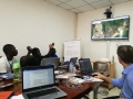
The workshop on “Land cover mapping to support natural resources assessment and conflict mitigation strategies in South Sudan” have the multiple objectives to: provide a training to national experts on land cover mapping methodologies; discuss on land cover classification system...
From 29 January 2018 to 30 January 2018
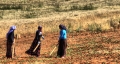
Under the outputs 1 and 2 of the project GCP/TUR/063/EC, co-financed by the European Union and the Republic of Turkey, a workshop has been organized at Ankara with the objective to present, discuss and validate the drought projection...
From 25 January 2018 to 25 January 2018

From 16 December 2017 to 22 December 2017
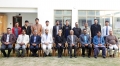
Under the "Building disaster resilience in Pakistan (BDRP)" Programme FAO’s Geospatial Unit has been supporting the implementation of Pakistan’s National Disaster Risk Reduction Policy Project (OSRO/Pak/601/UK)in the Sindh and Punjab provinces. The aim...
From 11 October 2017 to 12 October 2017
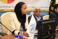
FAO and Government of Iran today launched a project that stablishes a prototype agriculture monitoring system, in three provinces in the country to improve the quality of agriculture information and reporting, based on geospatial technology. With the financial...