资源
本节包含以下列表:
- 地理数据门户和出版物,以传播粮农组织项目成果。
- 粮农组织利用的工具和地理空间方法以及相关电子学习课程。
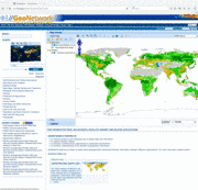
FAO Agro-Informatic Data Catalog
FAO Agro-Informatic Data Catalog is a free and open-source web-catalogue application to manage spatially referenced datasets designed to harmonize and improve access to FAO's spatial databases to support decision makers and to promote multidisciplinary approaches to sustainable development.
Read More...
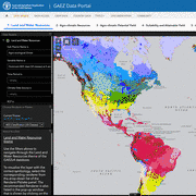
Global Agro-Ecological Zoning version 4 (GAEZ v4)
Global Agro-Ecological Zones (GAEZ) version 4 is the forth global assessment of land suitability, potential attainable yields and potential production of crops for specified management assumptions and input levels, both for rain-fed and irrigated conditions.
It provides users with thousands of global datasets and tabular outputs that are aggregated for current major land use/cover patterns and by administrative units, and land protection status for baseline periods and future projected scenarios.
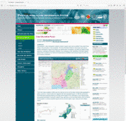
Information Portals
FAO develops web-based integrated portals for data dissemination.
An example is the Crop Information Portal of Pakistan, as part of the Pakistan Agriculture Information System. Core application is the data analysis and dissemination tool for statistics on crop production and conditions, agrometeorology, water resources, fertilizers use and market prices aggregated at district/province scale, integrated with satellite based information into a GIS environment.
Land Cover Land Registry
FAO land cover legend registry is the first international online catalogue for land cover legends. The legends are available at global, regional, national and sub-national level.