الأخبار
يقدّم هذا القسم مقالات وأخبارا عن الأنشطة التي تجريها المنظمة بالاستعانة بالتكنولوجيا والمنهجيات الجغرافية المكانية.
12 February 2018
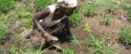
A workshop on “Land cover mapping to support natural resources assessment and conflict mitigation strategies in South Sudan” took place at Juba from 12 to 16 February.
The training is part of a project, funded by the European Commission,...
29 January 2018

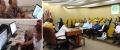
Under the outputs 1 and 2 of the project GCP/TUR/063/EC, co-financed by the European Union and the Republic of Turkey, a meeting and a workshop were organized at Ankara on 29 and 30 January.
The purpose of the visit was...
25 January 2018


11 October 2017 Teheran - FAO and Government of Iran today launched a project that stablishes a prototype agriculture monitoring system, in three provinces in the country to improve the quality of agriculture information and reporting, based on...
The training course on land cover mapping and accuracy assessment was organized by the Geospatial Unit of FAO from 19-21 September under the Regional Food Security Analysis Network (RFSAN), within the project Strengthening of an inclusive food...