Новости
В настоящем разделе публикуются статьи и новости о деятельности ФАО, связанной с применением геопространственных технологий и методик.
28 March 2018

This month FAO welcomed the new Head of the Geospatial Unit, Douglas Muchoney and launched this new website: ‘Geospatial information for sustainable food systems’. Both come at an opportune moment as FAO expands its work to...

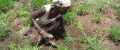
Under the ‘Building disaster resilience in Pakistan (BDRP)’ Programme, FAO’s Geospatial Unit has been supporting the implementation of Pakistan’s National Disaster Risk Reduction Policy Project in the Sindh and Punjab provinces.
This month, following a similar...
12 February 2018
A workshop on “Land cover mapping to support natural resources assessment and conflict mitigation strategies in South Sudan” took place at Juba from 12 to 16 February.
The training is part of a project, funded by the European Commission,...
29 January 2018

Under the outputs 1 and 2 of the project GCP/TUR/063/EC, co-financed by the European Union and the Republic of Turkey, a meeting and a workshop were organized at Ankara on 29 and 30 January.
The purpose of the visit was...
25 January 2018