![]()
![]()
![]()
2.1 The shelf area
2.2 Hydrography
Gabon has a coastline of 380 nm. The total shelf area is about 11911 nm and the mean width is thus about 30 nm. The extension of the shelf by depth ranges is shown in Table 2.
|
Table 2. The shelf off Gabon by bottom depth strata
(nm2) |
||
|
|
North of C. Lopez |
South of C. Lopez |
|
0-50 m |
2340 nm2 |
4182 nm2 |
|
50-100 m |
442 nm2 |
2893 nm2 |
|
100-200 m |
576 nm2 |
1478 nm2 |
During the surveys the sea temperature at 4 m of depth was observed on a continuous basis along the course tracks and hydrographic profiles were worked over the shelf and off the slope offshore to 500 m of depth in the positions shown in the maps in Annex I. In order to obtain a meaningful picture of the hydrographic regime and the seasonal changes in this region, observations from the Congo and northern Angola have been included in the following analysis. In this we will briefly describe the characteristics of the water masses as observed in February-March, May-June, September and December 1985 and conclude by outlining the dynamics of the regimes.
The region is situated in the southern meteorological hemisphere and characterized by southerly trade winds regulated by the South Atlantic Pressure Cell and the high pressure field over the northern region of the African Continent. The winds are therefore stable in direction and weak in speed during most of the year.
The hydrographical parameters especially in the surface layers are modified by the intensive solar radiation, the rainfalls and the river discharges notably that from the Congo, the second largest river in the world.
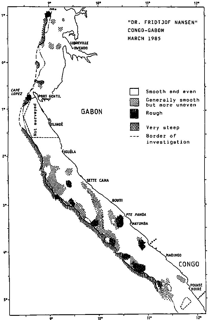
Figure 1. The bottom conditions as registrated by the acoustic system.
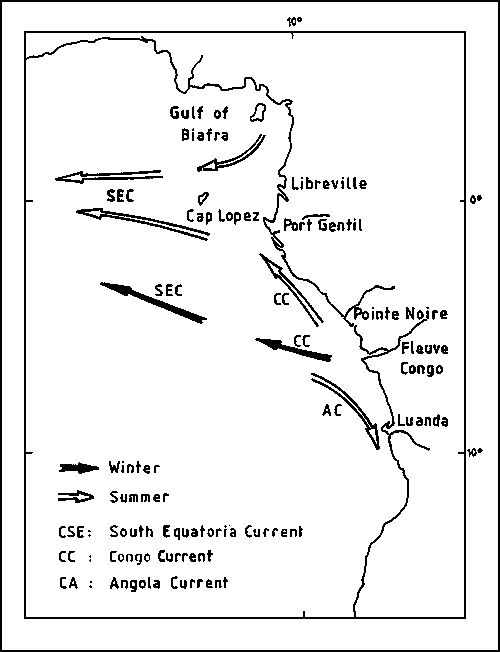
The circulation pattern is dominated by the South Equatorial Current which flows to the west seawards from the northern Gabon coast. The northern inshore branch of this current transports low-saline warm water from the Gulf of Biafra southwest along the north Gabon coast. Of importance is also the Congo Current which in summer flows northwards transporting low saline water originating from the Congo River along the coast as far as Cape Lopez. In austral winter the Congo Current flows offshore towards the west.
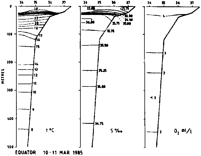
March 1985
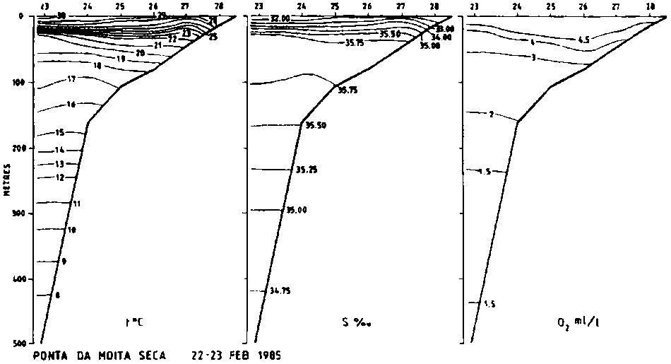
Figure 2 shows the hydrographical sections worked. The surface temperatures are high and show only slight variations within the range 28-30°C as a result of intensive solar radiation which is a characteristic of this time of the year, austral summer. There is a well developed shallow thermocline in all sections. The effects of the Congo discharges are particularly noteable in this season of heavy rainfalls, and low salinity surface waters are found both to the south and to the north of the river indicating the directions at this time of the Angola - respectively Congo currents. The intermediate layer of high salinity at 50-100 m of depth probably has its origin in the Equatorial Counter Current.
May - June 1985
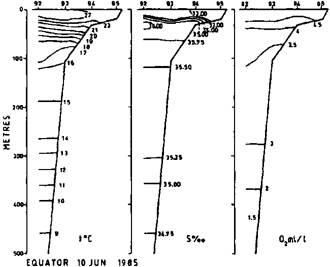
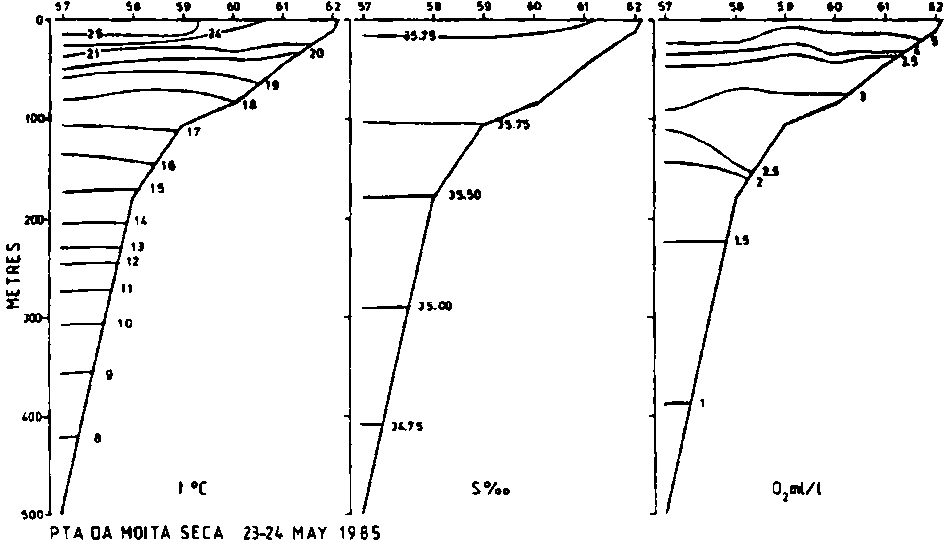
The hydrographical profiles worked are shown in Figure 3. In the southern region the surface temperature are now with 21-22°C well below the values found in March and the profiles indicate that some slight process of upwelling may occur here, while further north the surface temperatures inshore are still high. The low salinity surface water in the Equator profile derives from the Gulf of Biafra. No low-salinity water is found in the profiles north and south of the Congo indicating the offshore westward direction of the current in this season.
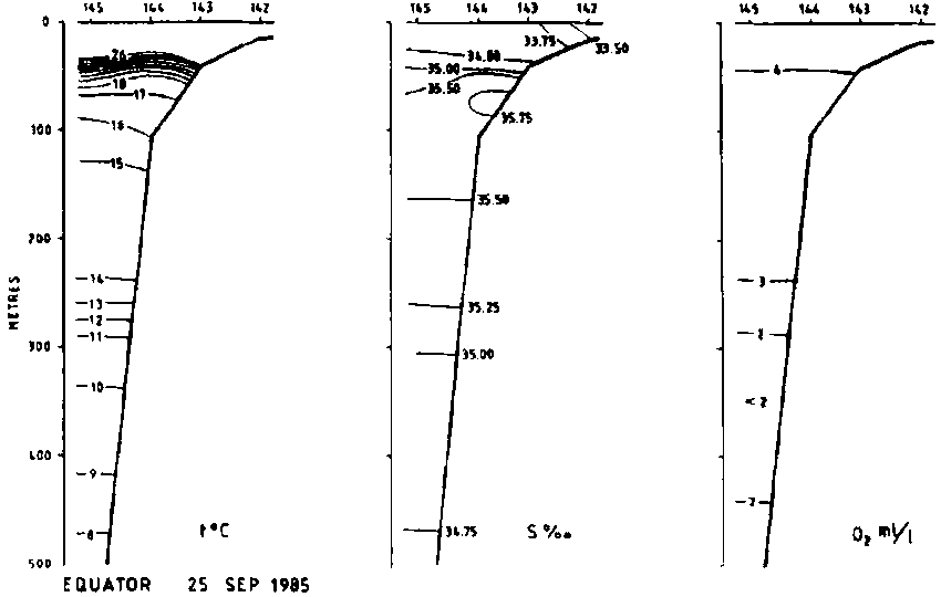
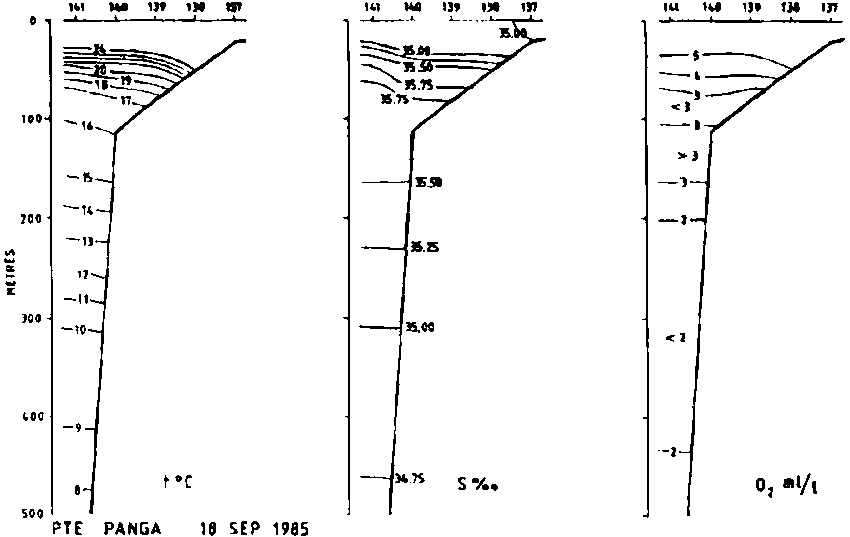
September 1985
The distribution of surface temperature shows pockets of cool water, 22-23°C outside Pointe Noire, perhaps indicating local upwelling, but the profiles, Figure 4 show well stratified water further north. The low-salinity surface water on the Equator profile indicates transport from the north.
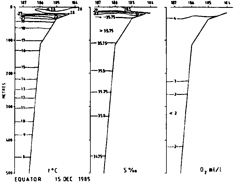
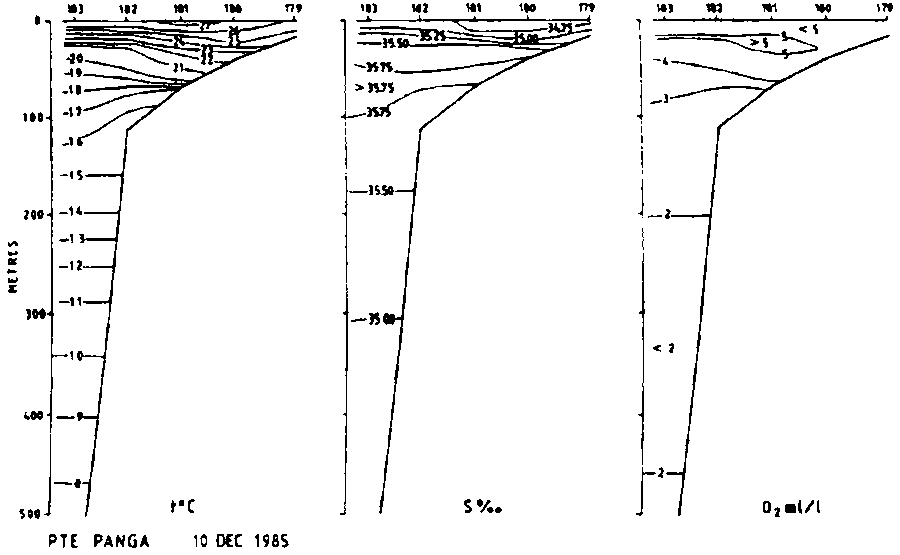
December 1985
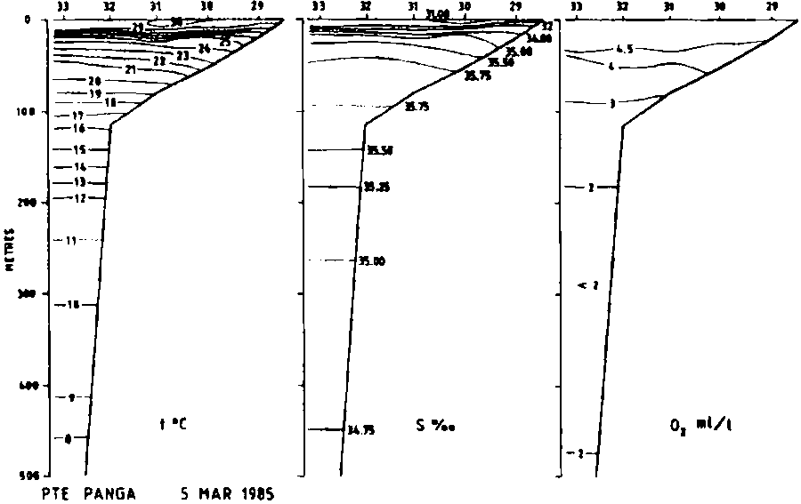
Again pockets of cool water off the Congo may indicate local upwelling processes, but there is little evidence of this in the profiles further north, Figure 5. A northward flow of surface water along the coast is indicated by the relatively low surface salinity in the Pte. Panga profile.
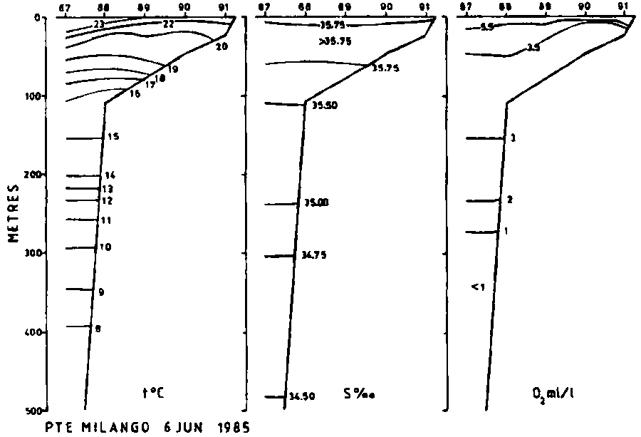
In all profiles oxygen inside the shelf edge is about 3 ml/l or more, i.e. values which are not likely to affect fish distribution. Oxygen contents of less than 1 ml/l are only observed off the shelf at depths of 300 m or more.
Discussion
Two main hydrographical seasons may be distinguished, relating to the austral summer, about December to March, and to the austral winter about June to September. With the intensive solar radiation in summer surface temperatures are high, 28-30°C and a strong thermocline is usually found at 20-30 m of depth. Being the period of maximum rainfall there is a high input of fresh water through the discharges of the Congo River and from the Gulf of Biafra.
Figure 2. Hydrographic sections from the February-March survey.
PONTA DA MOITA SECA - 22-23 FEB 1985
Figure 3. Hydrographic sections from the May-June survey.
PTA DA MOITA SECA - 23-24 MAY 1985
Figure 4. Hydrographic sections from the September survey.
Figure 5. Hydrographic sections from the December survey.
The fresh water outflows reduces the salinity of the surface layers and the currents along the coast may be revealed by tracing the low-salinity water. It is thus evident that in summer the Congo Current flows northwards along the coast up to and perhaps somewhat beyond Cape Lopez. In winter there is some decrease of surface temperature over the shelf, with the lowest values in the inshore southern parts where some upwelling seem to take place. This upwelling may be related to the changed direction in winter of the Congo Current now flowing westwards off the shelf and merging seawards with the South Equatorial Current. The Gabon coast north of Cape Lopez is apparently affected by the shoreward branch of the South Equatorial Current throughout the year carrying warm low salinity surface water from the Gulf of Biafra. The circulation pattern of the surface waters as described here is illustrated in Figure 6.
The thermocline is strongest during summer, being situated at 20-30 m of depth, and moves slightly higher during winter weakening somewhat. An intermediate layer of maximum salinity occurs at about 50-100 m presumably originating from the Equatorial Counter Current.
Figure 6. General circulation pattern of surface layers in austral summer and winter.
![]()
![]()
![]()