Publications
The development and adoption of land cover data standards are critical for supporting global efforts to address the challenges related to climate change, sustainable development, and disaster risk reduction. By providing consistent and interoperable land...
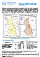
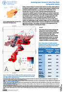
Baseline land degradation status in the watersheds of White Nile state, Sudan SDG Indicator 15.3.1
28 July 2023
28 July 2023
An assessment of land degradation was carried out following the UNCCD’s Good Practice Guidance (GPG) version 2 for the SDG Indicator 15.3.1 (Proportion of land that is degraded over total land area) for White Nile...
The Food and Agriculture Organization of the United Nations (FAO) provides technical support to countries and stakeholders to plan, implement and monitor land, water and crop resources. The Arab Organization for Agricultural Development (AOAD) provides...
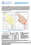
Baseline land degradation status in the watersheds of Al Qadarif state, Sudan SDG Indicator 15.3.1
24 July 2023
24 July 2023
An assessment of land degradation was carried out following the UNCCD’s Good Practice Guidance (GPG) version 2 for the SDG Indicator 15.3.1 (Proportion of land that is degraded over total land area) for Al Qadarif...
Better understanding of cropland water demand provides useful guidance for efficient irrigation practices. Cropland water demand is defined as the potential evapotranspiration, i.e., the amount of water that can be transferred to the air from...