Publications
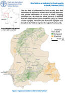
The rice field is fundamental to food security. Rice field information is required to monitor food security indicators and provide information on access to water, cropping intensities, and more. Rice field for Sindh province is...

Population data is required to monitor food security indicators and provide information on per capita land availability, production, and more. The population data is obtained from Worldpop (2020) and categorised into the urban population following...

Protected areas in Sindh, Pakistan (2017)
16 February 2023
16 February 2023
Protected areas were mapped to achieve the conservation-specific objectives as defined under Article 2 of the Convention on Biological Diversity (CBD). The datasets are obtained from the World Database on Protected Areas (UNEP-WCMC). The extent...

Land degradation assessment of Alto Hama, Angola
16 February 2023
16 February 2023
A land degradation assessment has been conducted for Alto Hama commune in Huambo province, Angola. A land cover legend was prepared using LCML/LCCS v3 based on key degradation processes identified in the area. Land cover...

Land degradation assessment of Chipipa, Angola for 2001-2015, 2015-2018 and 2018-2021
16 February 2023
16 February 2023
A land degradation assessment has been conducted for Chipipa commune in Huambo province, Angola. A land cover legend was prepared using LCML/LCCS v3 based on key degradation processes identified in the area. Land cover maps...