Actualités
Cette section présente des articles et des informations sur les activités réalisées par la FAO à l’aide de technologies et de méthodes géospatiales.
24 November 2020

Unprecedented damages have been recorded after Category 5 hurricane Iota passed over Providencia Island, Columbia between the 15th and 16th of November 2020. Communication to the island was lost for at least 20 hours. In order to rapidly...
15 November 2020
Record rainfall in this rainy season in 2020 has had an impact on West African countries. As of October 10, 2020, floods affected an estimated 2.1 million people in many regions of West and Central Africa. The impact...

Innovative land cover monitoring and change detection applications are being used by the Ministry of Housing, Territorial Planning and Environment of Uruguay (MVOTMA) with technical support from FAO for improved land and water management, sustainable agriculture and ecosystem services. Technical...

The super-cyclone Amphan slammed into the coast of eastern India and Bangladesh on Wednesday 20 May 2020, generating severe winds and heavy rainfalls, bringing heavy gales and the threat of deadly storm surges. An estimated 10 million people in 19...
01 April 2020
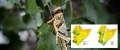
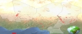
The locust upsurge affecting East Africa is a graphic and shocking reminder of this region's vulnerability. The upsurge comes as an exacerbating factor to food insecurity. Indeed, the East and Horn of Africa region is already home to some of...