Actualités
Cette section présente des articles et des informations sur les activités réalisées par la FAO à l’aide de technologies et de méthodes géospatiales.
10 September 2018
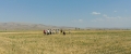
FAO’s Subregional Office for Central Asia led workshops and field trips to the Turkish provinces of Ankara, Konya, Erzurum in July and September 2018 under the project ’Agricultural implications for ecosystem-based adaptation to climate change in Steppe ecosystems’....
29 May 2018
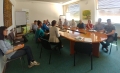
The Republic of Turkey’s Ministry of Food, Agriculture and Livestock (MFAL) is working on a detailed action plan to implement and monitor Ecosystem-Based Adaptation (EBA) in the Anatolian Steppe following April’s ‘study tour’ workshop at FAO Headquarters.
The...
02 April 2018

Last month’s workshop on Regional Land Cover Monitoring in Bangkok saw a strong coordinated effort among participating countries from the Hindu Kush-Himalayan region, to use the same land cover classification systems and produce regionally standardized land cover maps....
28 March 2018

This month FAO welcomed the new Head of the Geospatial Unit, Douglas Muchoney and launched this new website: ‘Geospatial information for sustainable food systems’. Both come at an opportune moment as FAO expands its work to...

Under the ‘Building disaster resilience in Pakistan (BDRP)’ Programme, FAO’s Geospatial Unit has been supporting the implementation of Pakistan’s National Disaster Risk Reduction Policy Project in the Sindh and Punjab provinces.
This month, following a similar...