Actualités
Cette section présente des articles et des informations sur les activités réalisées par la FAO à l’aide de technologies et de méthodes géospatiales.

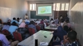
In the Central African Republic, the Ministry of Agriculture, in collaboration with the World Bank, successfully concluded the first computerized spatial data management course for the "Emergency Response Project to the Food Crisis" (PRUCAC). The training, held at FAO headquarters...

The Geospatial Unit of the Food and Agriculture Organization of the United Nations (FAO) and the Arab Organization for Agricultural Development (AOAD) organized a virtual technical workshop from 14 to 16 March 2023 on the use of remote sensing and...
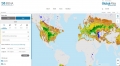
The Food and Agriculture Organization of the United Nations (FAO) and the International Renewable Energy Agency (IRENA) have collaborated to make available priority geospatial layers of agro-ecological zoning from the Global Agro-Ecological Zoning version 4 (GAEZ v4) on the...
10 February 2023
Innovative technologies, machine learning and big data have the potential to accelerate progress in improving access to land resource information. The Gums for Adaptation and Mitigation in Sudan (GAMS) project aims to strengthen the adaptive capacity of local communities and...
21 November 2022

An international consultation on the development of the new land characterization system software (LCHS) has been organized on 21 November 2022 by Food and Agriculture Organization of the United Nations (FAO) in collaboration with National Research Council - CNR, Italy....